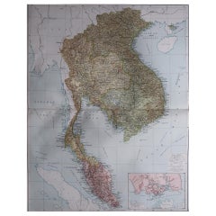
Items Similar to An Old Illustrated Tallis Map of Central America with Volcanic Vignettes, 1851


Want more images or videos?
Request additional images or videos from the seller
1 of 7
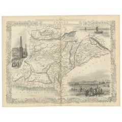
An Old Illustrated Tallis Map of Central America with Volcanic Vignettes, 1851
About the Item
This map of Central America, part of John Tallis & Company's series from "The British Colonies" by Robert Montgomery Martin, is a fine example of mid-19th century cartography and would be around the time when the region was of increasing interest to British and global trade, particularly due to the considerations for creating a canal across the isthmus to enhance trade routes.
**The Maker - John Tallis & Company:**
John Tallis is renowned for his detailed maps with characteristic decorative vignettes. Tallis maps are known for not only their cartographic accuracy but also for their artistic embellishments. They often included elaborately drawn borders and detailed scenes relevant to the area depicted on the map.
**The Map - Central America:**
The map in question likely details the geographical features of Central America, including countries such as Guatemala, Belize, Honduras, El Salvador, Nicaragua, Costa Rica, and Panama. During the mid-1800s, many of these regions would have been newly independent from Spain or undergoing political changes, and some were still under British influence, such as the British Honduras, now known as Belize.
**The Countries:**
Central American countries have diverse landscapes that include coastlines on both the Atlantic and Pacific Oceans, mountain ranges, volcanoes, and rainforests. The region has a rich history, from the ancient Mayan civilization to the colonial period, and eventually the national independence movements in the 19th century.
**The Images on the Map:**
The illustrations on Tallis maps usually include important cities, landmarks, local flora, fauna, and scenes depicting the life of the inhabitants. For Central America, images might include representations of indigenous people, colonial architecture, landscapes with volcanoes, and scenes from ports or other hubs of economic activity.
**The Tallis Series:**
The series "The British Colonies" aimed to provide a comprehensive overview of the British Empire's reach and influence. It was common during that era for such works to be a source of national pride and educational material for those in the metropole. The inclusion of artistic renditions of local scenes and landscapes served to make these maps more engaging and provided a narrative of exotic lands and colonial life.
Collectors and enthusiasts of historical maps prize Tallis maps for their beauty and detail, making them valuable items for collections that focus on cartographic history, Victorian art, and the history of exploration and colonialism.
More details of the insets:
The insets on the Tallis map of Central America pictures of are detailed illustrations that showcase significant landmarks and scenes from the region. Here's a description of each:
1. **The Title "Central America"**: Adorned with a decorative motif, the title sits prominently at the top of the map, framed by ornate scrollwork that is typical of Tallis' style.
2. **Volcano of Isalco**: This inset illustrates the Volcano of Isalco in El Salvador, one of the most active volcanoes in Central America. It is shown emitting smoke, with a church and other buildings in the foreground, indicating human settlement and activity near the volcano.
3. **Great Square of Antigua, Guatemala**: This vignette depicts the central square of Antigua, the former capital of Guatemala. The image shows several individuals in the foreground, possibly locals or travelers, with the grand colonial architecture of the city and the imposing volcanoes in the background, reflecting the blend of natural and urban landscapes of the region.
4. **Costa Rica**: Although not an inset of a specific scene, this portion of the map details the geographical features of Costa Rica, including its borders, main towns, and topography.
5. **Belise [Belize]**: The vignette represents Belize, known at the time as British Honduras. It shows a coastal town with several boats, including one with a large sail, navigating choppy waters. This scene highlights the maritime culture and tropical climate of Belize.
6. **Mosquito Coast**: The map details the region known as the Mosquito Coast, which extended along the eastern coast of Central America, from Belize down through Nicaragua. It was named after the Miskito Kingdom and was an area of interest due to its strategic location and natural resources.
These insets and illustrations provide a visual narrative that complements the geographic information on the map. They not only serve an aesthetic purpose but also help to contextualize the cultural and natural environment of the region during the era. Such features would have been particularly appealing to 19th-century audiences, who were eager to learn about and visualize distant lands. For modern collectors, these vignettes add historical value and depth to the map, making it a more attractive and informative piece.
- Dimensions:Height: 10.71 in (27.2 cm)Width: 14.26 in (36.2 cm)Depth: 0 in (0.02 mm)
- Materials and Techniques:
- Period:
- Date of Manufacture:1851
- Condition:Good given age. Original fold in middle as published. General age-related toning, please study scan carefully.
- Seller Location:Langweer, NL
- Reference Number:
About the Seller
5.0
Platinum Seller
These expertly vetted sellers are 1stDibs' most experienced sellers and are rated highest by our customers.
Established in 2009
1stDibs seller since 2017
1,928 sales on 1stDibs
Typical response time: <1 hour
- ShippingRetrieving quote...Ships From: Langweer, Netherlands
- Return PolicyA return for this item may be initiated within 14 days of delivery.
More From This SellerView All
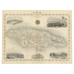
- An Ornate and Historical Tallis Map of Jamaica with Decorative Vignettes, 1851Located in Langweer, NLThis original antique map of Jamaica is part of the renowned series created by the Tallis Company, known for their detailed and decorative maps of the 19th century. The company was f...Category
Antique 1850s Maps
MaterialsPaper
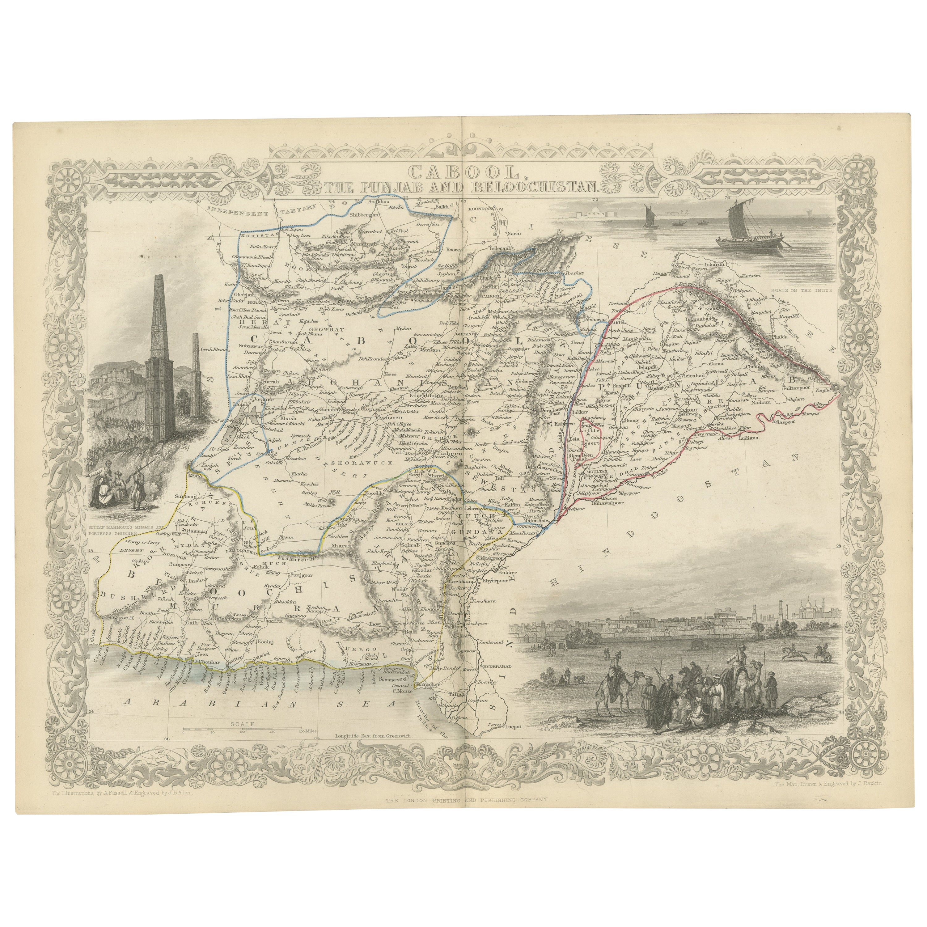
- An Illustrated Map of Kabul, Punjab, and Baluchistan by Tallis, 1851Located in Langweer, NLThis map, attributed to John Tallis and featuring the work of Robert Montgomery Martin, is part of a series created for the publication "The British Colonies." John Tallis & Company ...Category
Antique 1850s Maps
MaterialsPaper
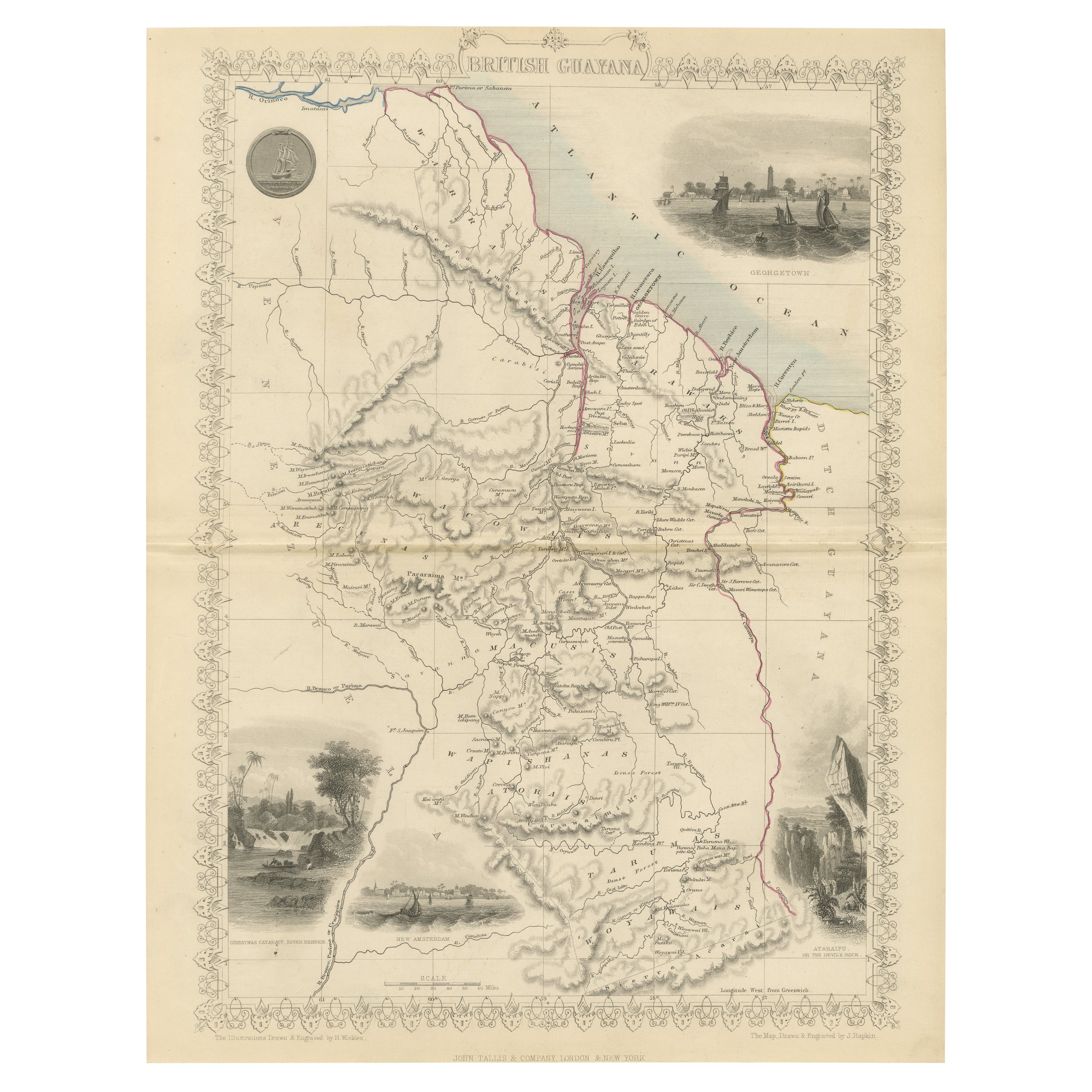
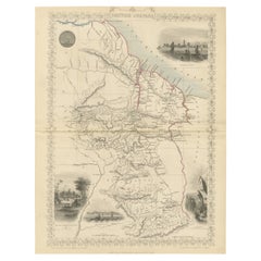
- A Tallis Map of British Guiana with Colonial Vignettes and Other Landmarks, 1851Located in Langweer, NLThis Tallis map of British Guiana (now known as Guyana) is a richly decorated document, much like other maps from the esteemed cartographic publisher John Tallis & Company. The firm,...Category
Antique 1850s Maps
MaterialsPaper
- Old Engraved Map of Hungary with Decorative Vignettes, 1851Located in Langweer, NLAntique map titled Hungary. Includes decorative vignettes titled Hungarian Peasants, Pesth and the Fortress of Buda, on the Danube and Hungarian Nobles. Originates from 'The Illustrated Atlas, And Modern History Of The World Geographical, Political, Commercial & Statistical, Edited By R. Montgomery Martin'. Published; John Tallis London, New York, Edinburgh & Dublin. 1851. Drawn and Engraved by J. Rapkin. Artists and Engravers: John Tallis (1817-1876) was a British map publisher. Born in the Midlands, Tallis came to London in the 1840s. Tallis began his London career with a series of remarkable London street views. He began a partnership with a Frederick Tallis, possibly his brother, but their collaboration ended in 1849. For the Great Exhibition of 1851, Tallis published the Illustrated World Atlas, one of the last series of decorative world maps ever produced. The maps were engraved by John Rapkin, a skilled artisan. The maps were later reissued by the London Printing & Publishing Company, who left the Tallis imprint intact, thus ensuring his enduring fame. In 1858, he began publication of the popular Illustrated News of the World...Category
Antique 19th Century Maps
MaterialsPaper
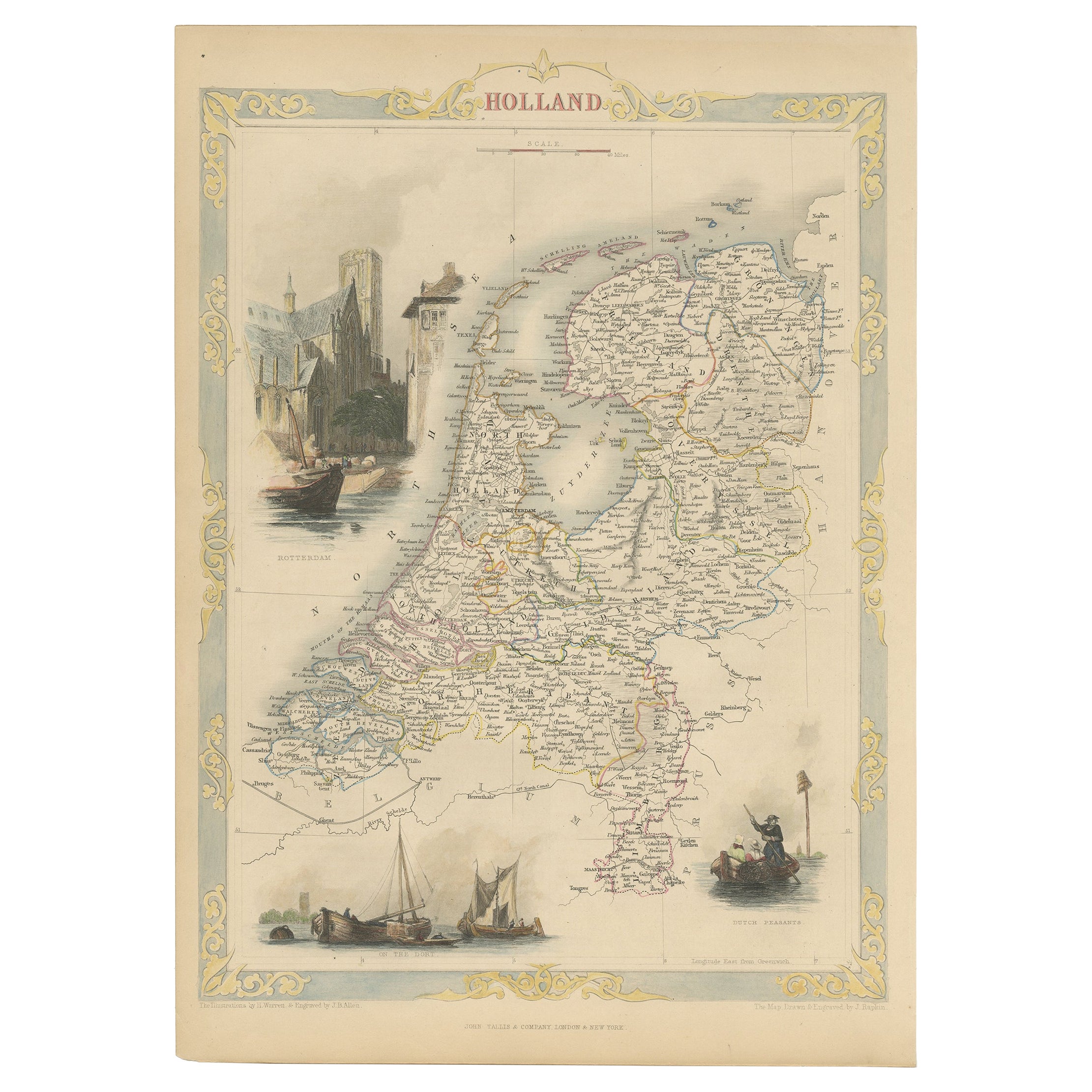
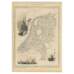
- Antique Map of Holland with Colorful Vignettes, 1851Located in Langweer, NLAntique map titled 'Holland'. Decorative map of Holland. Includes vignettes of Rotterdam, Dutch Peasants and a boating scene on the Dort, the Netherlands. Originates from 'Th...Category
Antique 19th Century Maps
MaterialsPaper
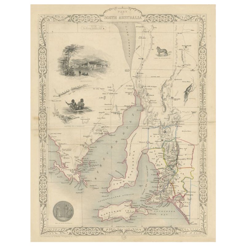
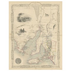
- Antique Map of South Australia by Tallis, 1851By Thomas KitchinLocated in Langweer, NLAntique map Australia titled 'Part of South Australia'. Decorative map of part of South Australia, surrounded by illustrations of Adelaide, natives on a catamaran, an Australian dog and a nymphicus bird illustrated. Originates from 'The Illustrated Atlas, And Modern History Of The World Geographical, Political, Commercial & Statistical, Edited By R. Montgomery Martin'. Published; John Tallis London, New York, Edinburgh & Dublin. 1851. Drawn and Engraved by J. Rapkin. Artists and Engravers: John Tallis (1817-1876) was a British map...Category
Antique 19th Century Maps
MaterialsPaper

You May Also Like
- Antique Map of American Cities, Vignette of New York City, circa 1920Located in St Annes, LancashireGreat maps of American Cities Unframed Original color By John Bartholomew and Co. Edinburgh Geographical Institute Published, circa 1920Category
Vintage 1920s British Maps
MaterialsPaper
- Original Antique Map of Central America / Florida, Arrowsmith, 1820Located in St Annes, LancashireGreat map of Central America. Drawn under the direction of Arrowsmith. Copper-plate engraving. Published by Longman, Hurst, Rees, Orme and Brown, 1820 Unframed.Category
Antique 1820s English Maps
MaterialsPaper
- Illustrated Map of London from ExhibtionLocated in Alton, GBDetailed illustrated map of London from the great exhibition of industry of all nations 1851.Category
Antique 19th Century Maps
MaterialsPaper
- Large Original Vintage Map of S.E Asia, with a Vignette of SingaporeLocated in St Annes, LancashireGreat map of South East Asia Original color. Good condition Published by Alexander Gross Unframed.Category
Vintage 1920s English Maps
MaterialsPaper
- Original Antique Map of Belgium by Tallis, Circa 1850Located in St Annes, LancashireGreat map of Belgium Steel engraving Many lovely vignettes Published by London Printing & Publishing Co. ( Formerly Tallis ), C.1850 Origin...Category
Antique 1850s English Maps
MaterialsPaper
- 1851 Map of "Independent Tartary", Ric. R018Located in Norton, MA1851 Map of Independent Tartary "Russia" Ric.r018 A highly decorative 1851 map of Independent Tartary by John Tallis and John Rapkin. Covers the regions between the Caspian Sea and Lake Bakquash and between Russia and Afghanistan. These include the ancient Silk Route kingdoms of Khiva, Tartaria, Kokand, and Bokhara. Today this region roughly includes Kazakhstan, Uzbekistan, Turkmenistan, Kyrgyzstan, and Tajikistan. This wonderful map offers a wealth of detail for anyone with an interest in the Central Asian portion of the ancient Silk Road. Identifies various caravan routes, deserts, wells, and stopping points, including the cities of Bokhara and Samarkand. Three vignettes by W. Bragg decorate the map, these including an image of Tartars on a Journey, a horseback Bride Chase, and a tartar camp site. Surrounded by a vine motif border. Engraved by J. Rapkin for John Tallis's 1851 Illustrated Atlas . Tartary Antique Map...Category
Antique 19th Century Unknown Maps
MaterialsPaper