Items Similar to 1616 Petrus Kaerius Map of Southern India and Ceylon – Narsinga et Ceylon


Want more images or videos?
Request additional images or videos from the seller
1 of 10
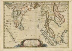
1616 Petrus Kaerius Map of Southern India and Ceylon – Narsinga et Ceylon
$580.77
£432.37
€490
CA$800.21
A$891.03
CHF 471.20
MX$10,843.28
NOK 5,939.54
SEK 5,595.92
DKK 3,730.14
About the Item
Title: 1616 Petrus Kaerius Map of Southern India and Ceylon – Narsinga et Ceylon
This rare early 17th-century copper engraved map titled 'Narsinga et Ceylon' was created by Petrus Kaerius (Pieter van den Keere) and published in 1616. It depicts the southern part of the Indian subcontinent, including the Coromandel and Malabar coasts, and the island of Ceylon (modern Sri Lanka), with remarkable detail for its size. The map comes from 'Caert-Thresoor', a pocket atlas first issued in 1598 and reprinted with updated plates through the early 17th century.
Key features include coastal towns such as Goa, Cochin, and Colombo, mountain ranges shown pictorially, and decorative cartouches framing the title and scale. It shows Portuguese place names such as Capelo and Dodolfsio, reflecting the Portuguese maritime dominance in the Indian Ocean during this period. The seas are labelled 'Mare Indicum' (Indian Ocean) and 'Sinus Gangeticus' (Bay of Bengal). The engraving is signed Petrus Kaerius caelavit in the scale cartouche, attesting to Kaerius’ role as both engraver and mapmaker.
Pieter van den Keere (Kaerius) was a prominent Dutch engraver and cartographer active in Amsterdam in the late 16th and early 17th centuries. His 'Caert-Thresoor' pocket maps were among the earliest affordable atlas maps available to merchants and scholars, preceding Blaeu’s and Mercator’s popular works. Maps from this series remain prized for their compact yet detailed style and historical value.
Condition report:
The map is in good condition for its age with strong engraving impressions. There is light age toning and minor foxing, with a few small edge nicks not affecting the image. The verso shows Latin text.
Framing tips:
This map will display elegantly in a slim black or dark wood frame with a gold inner edge to reflect its early 17th-century aesthetic. Pair it with a cream or warm ivory mat to highlight the paper’s natural tone, making it ideal for libraries, studies, or map collections focused on early colonial and maritime Asia.
- Dimensions:Height: 4.69 in (11.9 cm)Width: 7.33 in (18.6 cm)Depth: 0.01 in (0.2 mm)
- Materials and Techniques:Paper,Engraved
- Place of Origin:
- Period:Early 17th Century
- Date of Manufacture:1616
- Condition:The map is in good condition for its age with strong engraving impressions. There is light age toning and minor foxing, with a few small edge nicks not affecting the image. The verso shows Latin text.
- Seller Location:Langweer, NL
- Reference Number:Seller: BG-14072-11stDibs: LU3054345633872
About the Seller
5.0
Recognized Seller
These prestigious sellers are industry leaders and represent the highest echelon for item quality and design.
Platinum Seller
Premium sellers with a 4.7+ rating and 24-hour response times
Established in 2009
1stDibs seller since 2017
2,567 sales on 1stDibs
Typical response time: <1 hour
- ShippingRetrieving quote...Shipping from: Langweer, Netherlands
- Return Policy
Authenticity Guarantee
In the unlikely event there’s an issue with an item’s authenticity, contact us within 1 year for a full refund. DetailsMoney-Back Guarantee
If your item is not as described, is damaged in transit, or does not arrive, contact us within 7 days for a full refund. Details24-Hour Cancellation
You have a 24-hour grace period in which to reconsider your purchase, with no questions asked.Vetted Professional Sellers
Our world-class sellers must adhere to strict standards for service and quality, maintaining the integrity of our listings.Price-Match Guarantee
If you find that a seller listed the same item for a lower price elsewhere, we’ll match it.Trusted Global Delivery
Our best-in-class carrier network provides specialized shipping options worldwide, including custom delivery.More From This Seller
View All1654 Nicolas Sanson Map of Southern India and Southeast Asia
Located in Langweer, NL
1654 Nicolas Sanson Map of Southern India and Southeast Asia - Partie Meridionale de L'Inde
This 1654 map by Nicolas Sanson, titled "Partie Meridionale de L'Inde en deux Presqu'Is...
Category
Antique 1650s Maps
Materials
Paper
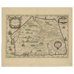
1638 Plancius Detailed Map of Sri Lanka or Ceylon with Decorative Cartouches
Located in Langweer, NL
"1638 Plancius Detailed Map of Sri Lanka with Decorative Cartouches"
This beautifully detailed map of Sri Lanka, titled "Ins. Ceilan," was engraved by P. Plancius from a design by C...
Category
Antique 1630s Maps
Materials
Paper
$1,365 Sale Price
20% Off
Colorful and Decorative Miniature Map of India, Ceylon by Bertius 1616
Located in Langweer, NL
Old 17th century miniature antique map of India - Ceylon from the 1616 edition of Jadocus Hondius Atlas by Petrus Bertius. Original copperplate engraving with hand coloring.
Carto...
Category
Antique 17th Century Maps
Materials
Paper

$369 Sale Price
20% Off
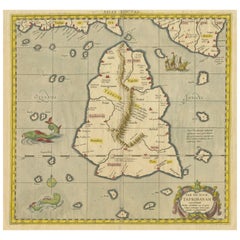
Antique Ptolemaic Map of Ceylon or nowadays Sri Lanka
Located in Langweer, NL
Antique map titled 'Tab XII. Asiae Taprobanam'. Ptolemaic map of Sri Lanka. Ptolemy drew on the accounts of travelers and sailors and though the information was secondhand and often ...
Category
Antique Mid-18th Century Maps
Materials
Paper
$654 Sale Price
20% Off
Rare and Very Old Antique Map of South East Asia, Published circa 1574
Located in Langweer, NL
A very fine impression of this map of the Malay Peninsula, Sumatra, Java, with Singapore denoted as 'Cinca Pula'.
Highly distorted and inaccurate map by Girolamo Ruscelli after J...
Category
Antique 16th Century Maps
Materials
Paper

$1,137 Sale Price
20% Off
Free Shipping
1705 Sanson Map of Southern India and Malabar with an Inset Map
Located in Langweer, NL
Title: 1705 Sanson Map of Southern India and Malabar with an Inset Map
Description: This finely engraved and beautifully hand-colored antique map, published in 1705, depicts south...
Category
Antique Early 1700s Maps
Materials
Paper

$730 Sale Price
20% Off
You May Also Like
1627 Hendrik Hondius Map Entitled "Vltoniae Orientalis Pars, " Ric.a009
Located in Norton, MA
1627 Hendrik Hondius map entitled
"Vltoniae orientalis pars,"
Ric.a009
Title:
Vltoniae orientalis : pars
Title (alt.) :
Ultoniae orientalis pars
Creator:
Mercator, Gerh...
Category
Antique 17th Century Dutch Maps
Materials
Paper

Ancient Map - Zeilan - Etching by Johannes Janssonius - 1650s
By Johannes Janssonius
Located in Roma, IT
Ancient Map - Zeilan is an ancient map realized in 1650 by Johannes Janssonius (1588-1664).
The Map is Hand-colored etching, with coeval watercoloring.
...
Category
1650s Modern Figurative Prints
Materials
Etching

Rugen Island, Germany: An Early 17th Century Map by Mercator and Hondius
By Gerard Mercator
Located in Alamo, CA
This is an early 17th century map entitled "Nova Famigerabilis Insulae Ac Ducatus Rugiae Desciptio" (Map of Rugen Island, Germany) by Gerard Mercator and Henricus and Joducus Hondiu...
Category
Early 17th Century Old Masters Landscape Prints
Materials
Engraving

West Africa: A 17th Century Hand-Colored Map by Mercator/Hondius
By Gerard Mercator
Located in Alamo, CA
A 17th century hand-colored map entitled "Guineae Nova Descriptio" by Gerard Mercator and Jodocus Hondius, published in their 'Atlas Minor' in Amsterdam in 1635. It is focused on the...
Category
1630s Landscape Prints
Materials
Engraving

Antique Map - Mare Pacificum - Etching by Johannes Janssonius - 1650s
By Johannes Janssonius
Located in Roma, IT
Mare Pacificum is an antique map realized in 1650 by Johannes Janssonius (1588-1664).
The Map is Hand-colored etching, with coeval watercolorang.
Good conditions with slight foxing...
Category
1650s Modern Figurative Prints
Materials
Etching

Antique French Map of Asia Including China Indoneseia India, 1783
Located in Amsterdam, Noord Holland
Very nice map of Asia. 1783 Dedie au Roy.
Additional information:
Country of Manufacturing: Europe
Period: 18th century Qing (1661 - 1912)
Condition: Overall Condition B (Good Used)...
Category
Antique 18th Century European Maps
Materials
Paper

$648 Sale Price
20% Off
More Ways To Browse
India Engraving
17th Century Copper
Southern Colonial
Antique Ivory Collectables
Ceylon Furniture
Copper Engraving Germany
17th Century German Engravings
Antique Gold Compact
17th Century Dutch Wood Frames
Portuguese Colonial Furniture
German Colonial
Colonial Sri Lankan
Goa Portuguese
Dutch Colonial Ceylon
Styles Of Antique Desks
Black And White Coffee Table
Curved Velvet Couch
Velvet Curved Sofa