Items Similar to 1640 Map of North Africa Nova Barbariae Descriptio or The Barbarian Coast


Want more images or videos?
Request additional images or videos from the seller
1 of 8
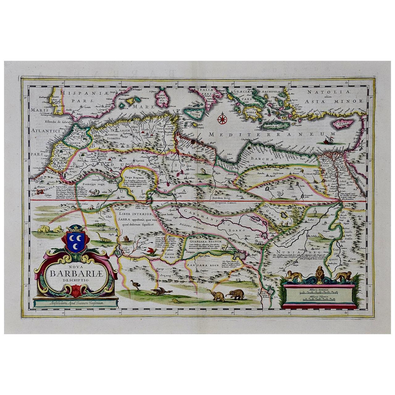
1640 Map of North Africa Nova Barbariae Descriptio or The Barbarian Coast
$459.93
$574.9220% Off
£340.83
£426.0420% Off
€384
€48020% Off
CA$627.89
CA$784.8720% Off
A$698.51
A$873.1320% Off
CHF 366.17
CHF 457.7120% Off
MX$8,535.59
MX$10,669.4820% Off
NOK 4,662.67
NOK 5,828.3420% Off
SEK 4,389.26
SEK 5,486.5720% Off
DKK 2,923.74
DKK 3,654.6820% Off
Shipping
Retrieving quote...The 1stDibs Promise:
Authenticity Guarantee,
Money-Back Guarantee,
24-Hour Cancellation
About the Item
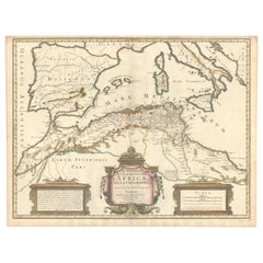
1640 Antique Map of North Africa 'Nova Barbariae Descriptio' by Johannes Janssonius
This antique map titled Nova Barbariae Descriptio*, published by Johannes Janssonius around 1640, offers a detailed view of North Africa and parts of the Mediterranean. The map covers the Barbary Coast, including modern-day Morocco, Algeria, Tunisia, and Libya, as well as parts of Spain, Italy, and Greece across the Mediterranean Sea. The decorative elements include a cartouche with crescent moons symbolizing the Islamic influence in North Africa. It also features animals like lions and rhinoceroses, representing the exotic fauna of Africa as perceived by European mapmakers of the time.
About the Mapmaker:
Johannes Janssonius (1588–1664) was a prominent Dutch cartographer during the Golden Age of Dutch cartography, producing beautifully illustrated and meticulously detailed maps. He was a rival of the Blaeu family, another notable mapmaking family in Amsterdam, and was known for his high-quality atlases, including *Atlas Novus*. Janssonius’s maps were popular for their geographical accuracy and decorative appeal, often included in grand atlases prized by European aristocrats and scholars.
Map’s Regions and Places:
-*Barbariae (Barbary Coast) – Extending along the coast of North Africa, encompassing the territories of present-day Morocco, Algeria, Tunisia, and Libya.
- Hispania Pars – Represents a portion of Spain across the Mediterranean, showcasing the proximity between Europe and North Africa.
- Mediterranean Sea – Centered between Europe and Africa, labeled *Mare Mediterraneum* with various islands marked, including Crete (*Candia*).
- Libya Interior – Refers to the interior desert regions south of the Barbary Coast, indicating limited knowledge of the area's geography.
- Tunis, Tripoli, Algiers – Major North African cities are marked as key coastal trading and cultural hubs.
- Nubia Regn. (Nubia) – Southeast region, hinting at the historic kingdoms along the Nile.
- Zanfara Regn. (Zamfara) and Guangara Regn. – Referencing ancient kingdoms within the Sahel region.
- Atlas Mountains – The mountain range across Morocco and Algeria is illustrated in a schematic style.
Condition Report:
The map is well-preserved with minimal signs of aging. Slight browning and minor foxing are present and overal toning. Original centerfold is intact, with mild wear along the crease. Colors are vibrant, and cartouche details remain clear.
- Dimensions:Height: 20.08 in (51 cm)Width: 23.43 in (59.5 cm)Depth: 0 in (0.02 mm)
- Materials and Techniques:Paper,Engraved
- Period:1640-1649
- Date of Manufacture:1640
- Condition:The map is well-preserved with minimal signs of aging. Slight browning and minor foxing are present and overal toning. Original centerfold is intact, with mild wear along the crease. Colors are vibrant, and cartouche details remain clear.
- Seller Location:Langweer, NL
- Reference Number:Seller: BG-13647-21stDibs: LU3054342044102
About the Seller
5.0
Recognized Seller
These prestigious sellers are industry leaders and represent the highest echelon for item quality and design.
Platinum Seller
Premium sellers with a 4.7+ rating and 24-hour response times
Established in 2009
1stDibs seller since 2017
2,494 sales on 1stDibs
Typical response time: 1 hour
- ShippingRetrieving quote...Shipping from: Langweer, Netherlands
- Return Policy
Authenticity Guarantee
In the unlikely event there’s an issue with an item’s authenticity, contact us within 1 year for a full refund. DetailsMoney-Back Guarantee
If your item is not as described, is damaged in transit, or does not arrive, contact us within 7 days for a full refund. Details24-Hour Cancellation
You have a 24-hour grace period in which to reconsider your purchase, with no questions asked.Vetted Professional Sellers
Our world-class sellers must adhere to strict standards for service and quality, maintaining the integrity of our listings.Price-Match Guarantee
If you find that a seller listed the same item for a lower price elsewhere, we’ll match it.Trusted Global Delivery
Our best-in-class carrier network provides specialized shipping options worldwide, including custom delivery.More From This Seller
View AllRare Antique Map of 'Barbarie' or Northern Africa, 1655
Located in Langweer, NL
Antique map titled 'Partie de la Coste de Barbarie en Africque ou sont les Royaumes de Tunis et Tripoli et Pays Circomvoisins'. This map depicts North Africa with Malta and originate...
Category
Antique 17th Century Maps
Materials
Paper

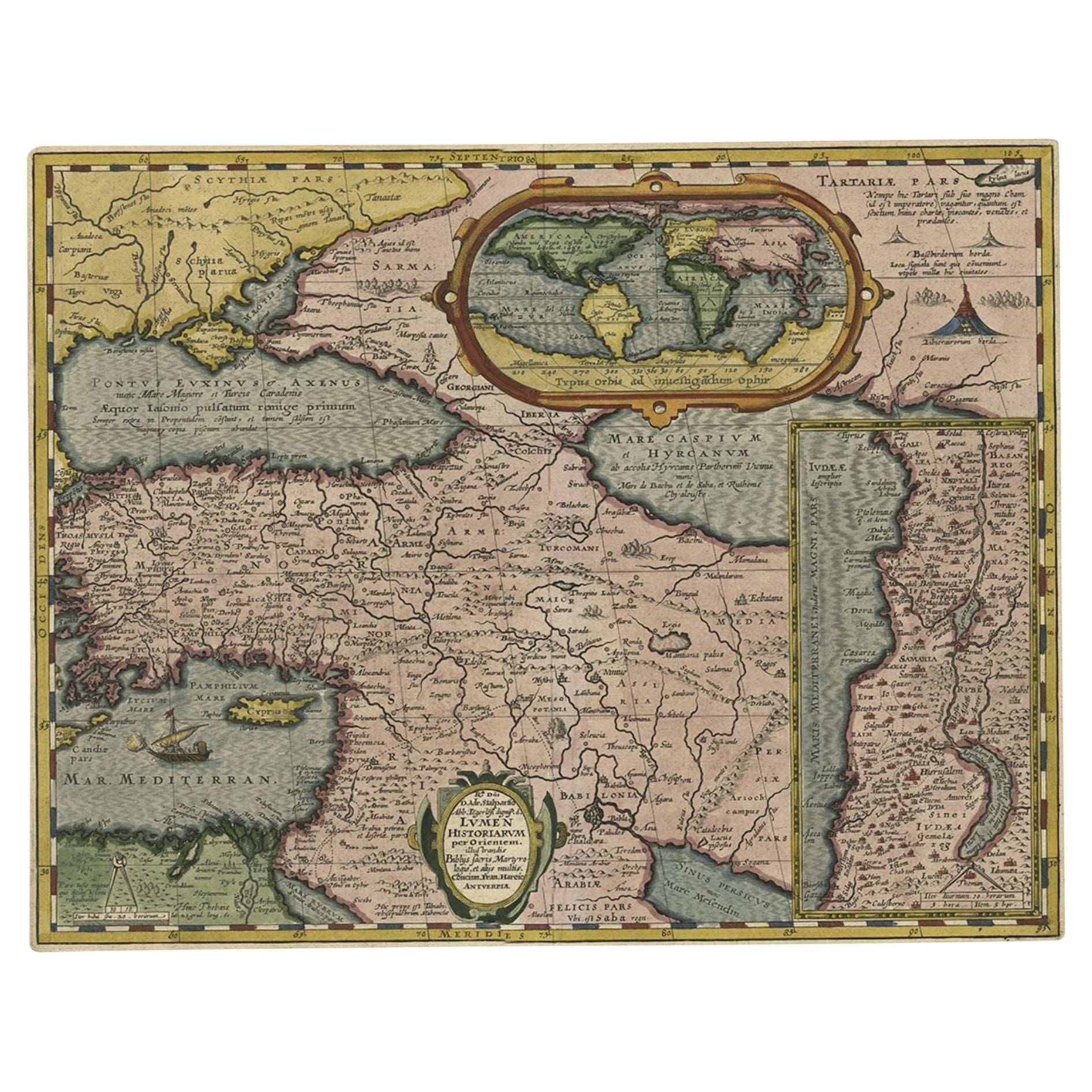
Scarce Antique Map of the Middle East, Surrounded by Latin Text, 1624
Located in Langweer, NL
Antique map titled 'Lumen Historium per Orientem (..).'
Scarce map of the Middle East, surrounded by Latin text. The two insets show Israel and an oval world map. This map (from the last edition of Ortelius Theatri Orbis Terrarum Parergon, 1624) was engraved by Franciscus Hareio. Later, this map was copied by Hornius for his World Atlas (1653).
Artists and Engravers: Franciscus Haraeus (Latinised form of Franciscus Verhaer; also known as Frans Verhaer), (Utrecht 1555? - Leuven, 11 January 1631), was a Dutch theologian, historian, and cartographer. He is best known for his history (from a Catholic point of view) of the Dutch Revolt...
Category
Antique 1620s Maps
Materials
Paper

$910 Sale Price
20% Off
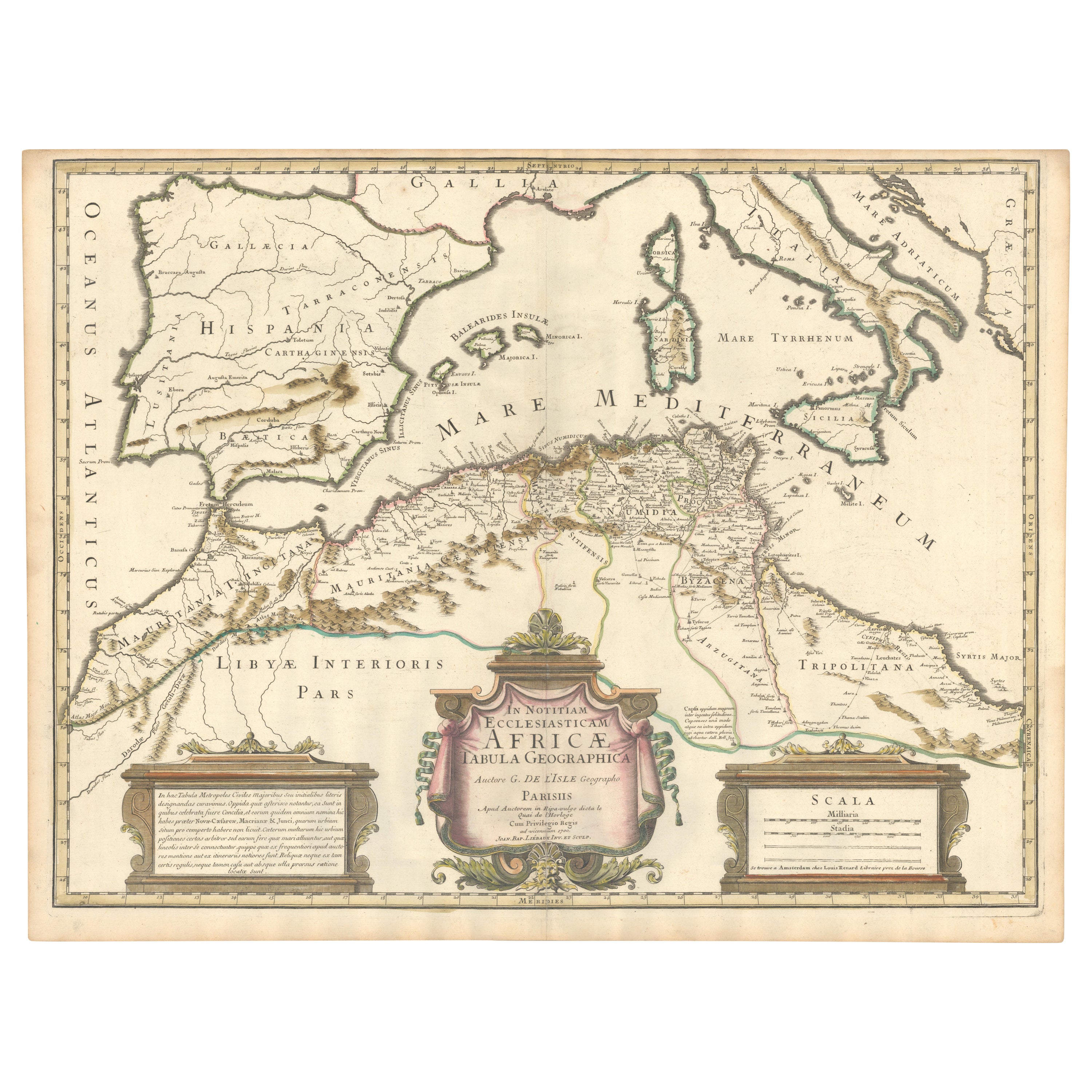
1700 Guillaume Delisle Map: Western Mediterranean & Moorish North Africa
Located in Langweer, NL
1700 Guillaume Delisle Map: Western Mediterranean & Moorish North Africa
This hand-colored map from 1700 by Guillaume Delisle, titled "In Notitiam Ecclesiasticam Africae Tabula Geographica," offers a detailed look at the regions under Moorish control during the later medieval period.
It encompasses the northern African coast from Morocco to Libya, the Iberian Peninsula, and the western Mediterranean, including notable islands such as Sardinia, Corsica, Malta, the Balearics, and Sicily, where a smoking Mount Etna is depicted.
The map is embellished with three decorative cartouches, adding artistic flair to the detailed geographical renderings.
Engraved by Jean Baptiste Liebaux, the map measures 25.2 inches wide by 19.1 inches high.
It features a sharp impression with contemporary outline color, later enhanced cartouches, and is printed on a bright sheet with a Society of Jesus watermark.
The condition is very good, with an archivally repaired centerfold separation at the bottom and light toning along the edges.
Keywords:
- Guillaume Delisle map
- Western Mediterranean historical map
- Northern Africa map...
Category
Antique Early 1700s Maps
Materials
Paper
$871 Sale Price
20% Off
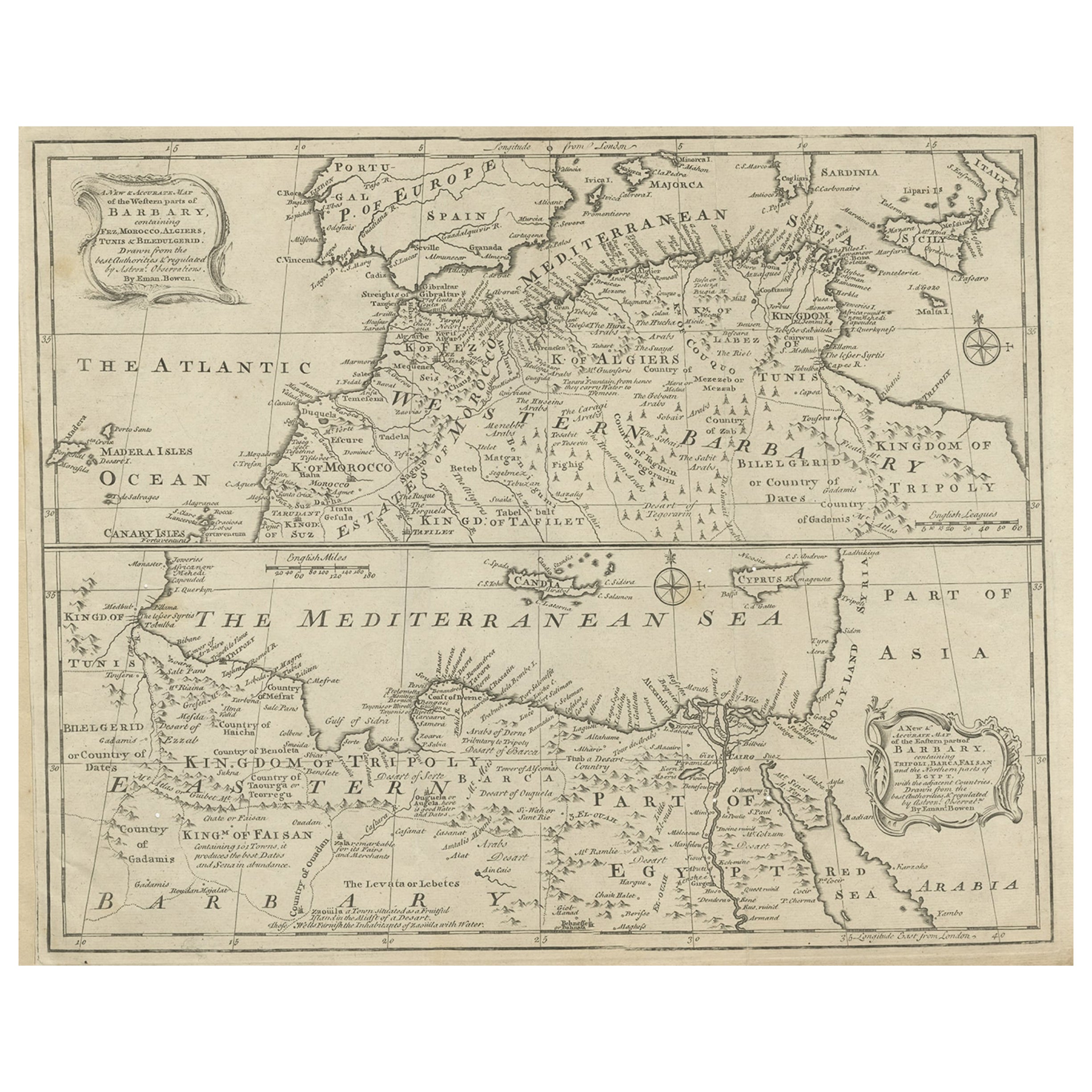
Antique Map of Western and Eastern Barbary in Africa, c.1744
Located in Langweer, NL
Antique map titled 'A New & Accurate Map of the Western Parts of Barbary' and 'A New & Accurate Map of the Eastern Parts of Barbary'. Decorative maps of North Africa and the Southern...
Category
Antique 18th Century Maps
Materials
Paper
Antique Map of the Northern Coast of Africa and Southern Europe, circa 1745
By Covens & Mortier
Located in Langweer, NL
Antique map titled 'In Notitiam Ecclesiasticam Africae Tabula Geographica'. Very decorative hand-colored map of the northern coast of Africa, Spain, Italy and the Mediterranean with the islands of Sardinia, Corsica, Majorca, Minorca etc. Sicily features a smoking Mount Aetna. Embellished with three architectural cartouches...
Category
Antique Mid-18th Century Maps
Materials
Paper

$306 Sale Price
67% Off
Attractive Antique Map of Western Africa with Lots of Details on the Coast, 1655
Located in Langweer, NL
Title: "L'Afrique, ou Lybie ulterieure ou sont le Saara, ou Desert, le pays des negres, la Guinee, et les Pays circonv. Tirée en partie de Sanut, et de l'Arabe de Nubie; en partie de diverses Cartes veües jusques a present".
Handsome map of Western Africa filled with information, much of it spurious, in the Sahara Desert, the Niger River and the coast of Guinea. Of particular interest are several incomplete rivers in the desert regions that appear and then disappear. The map is beautifully engraved with a title cartouche fashioned in the form of an oriental carpet.
The map shows a fantastic level of detail near the coastlines, which extends into legend and Ptolemaic myth in the interior of the continent. Detail is particularly extensive in Guinea and the Gold and Ivory Coasts. The Niger River is traced to its Malian lakes. The Mediterranean is barely visible in the northern part of the map. This map incorporates the discoveries made by Samuel Blommaert, who was director of the Dutch West Indies Company, in addition to traveling extensively to Africa and settling the oldest land deed...
Category
Antique 1650s Maps
Materials
Paper
$622 Sale Price
20% Off
You May Also Like
"Nova Barbariae Descriptio", a 17th Century Hand-Colored Map of North Africa
By Johannes Janssonius
Located in Alamo, CA
This original attractive 17th century hand-colored map of North Africa entitled "Nova Barbariae Descriptio" by Johannes Janssonius was published in Paris in 1635. It includes the Med...
Category
Antique Mid-17th Century Dutch Maps
Materials
Paper

1592 Abraham Ortelius Map "Lorraine: Lotharingiae Nova Descripti, Ric.A005
Located in Norton, MA
1592 Abraham Ortelius map entitled
"Lorraine: Lotharingiae Nova Descripti
Ric.a005
Description: Ortelius is best known for producing the atlas from which this map comes from, "...
Category
Antique 16th Century Dutch Maps
Materials
Paper

1633 Map Entitled "Beauvaisis Comitatus Belova Cium, Ric.0002
Located in Norton, MA
1633 map entitled
"Beauvaisis Comitatus Belova Cium,"
Hand Colored
Ric.0002
Description: Cartographer : - Hondius, Henricus 1587-1638
Artists and Engravers:Jodocus Hondius, one of the most notable engravers of his time. He is known for his work in association with many of the cartographers and publishers prominent at the end of the sixteenth and the beginning of the seventeenth century. A native of Flanders, he grew up in Ghent, apprenticed as an instrument and globe maker and map engraver. In 1584, to escape the religious troubles sweeping the Low Countries at that time, he fled to London where he spent some years before finally settling in Amsterdam about 1593. In the London period he came into contact with the leading scientists and geographers of the day and engraved maps in The Mariner\\\\\\\\\\\\\\\'s Mirrour, the English edition of Waghenaer\\\\\\\\\\\\\\\'s Sea Atlas, as well as others with Pieter van den Keere, his brother-in-law. No doubt his temporary exile in London stood him in good stead, earning him an international reputation, for it could have been no accident that Speed chose Hondius to engrave the plates for the maps in The Theatre of the Empire of Great Britaine in the years between 1605 and 1610. In 1604 Hondius bought the plates of Mercator\\\\\\\\\\\\\\\'s Atlas which, in spite of its excellence, had not competed successfully with the continuing demand for the Ortelius Theatrum Orbis Terrarum. To meet this competition Hondius added about 40 maps to Mercator\\\\\\\\\\\\\\\'s original number and from 1606 published enlarged editions in many languages, still under Mercator\\\\\\\\\\\\\\\'s name but with his own name as publisher. These atlases have become known as the Mercator/Hondius series. The following year the maps were reengraved in miniature form and issued as a pocket Atlas Minor. After the death of Jodocus Hondius the Elder in 1612, work on the two atlases, folio and miniature, was carried on by his widow and sons, Jodocus II and Henricus, and eventually in conjunction with Jan Jansson in Amsterdam.
In all, from 1606 onwards, nearly 50 editions with increasing numbers of maps with texts in the main European languages were printed. Summaries of these issues are given under the entry for Gerard Mercator. Jodocus Hondius the Elder * 1588 Maps in The Mariner\\\\\\\\\\\\\\\'s Mirrour (Waghenaer/Ashley) * 1590 World Map...
Category
Antique 17th Century Dutch Maps
Materials
Paper

Africa: A Large 17th Century Hand-Colored Map by Sanson and Jaillot
By Nicolas Sanson
Located in Alamo, CA
This large original hand-colored copperplate engraved map of Africa entitled "L'Afrique divisee suivant l'estendue de ses principales parties ou sont distingues les uns des autres, L...
Category
Antique 1690s French Maps
Materials
Paper

1633 Map "La Souverainete De Sedan Et De Raucourt, Et La Prevoste Ric0011
Located in Norton, MA
1653 map entitled
"La Souverainete de Sedan et de Raucourt, et la Prevoste de Doncheri,"
Ric0011
Description:
Lovely map centered on Sedan and Doncheri and the Meuze River fr...
Category
Antique 17th Century Dutch Maps
Materials
Paper

1627 Hendrik Hondius Map Entitled "Vltoniae Orientalis Pars, " Ric.a009
Located in Norton, MA
1627 Hendrik Hondius map entitled
"Vltoniae orientalis pars,"
Ric.a009
Title:
Vltoniae orientalis : pars
Title (alt.) :
Ultoniae orientalis pars
Creator:
Mercator, Gerh...
Category
Antique 17th Century Dutch Maps
Materials
Paper

More Ways To Browse
South African Antique
Antique Furniture South Africa
Antique Crete
Antique Rhinoceros
Barbary Lion
Tripoli Libya
Coffee Tables Europe
Marble Top Dining Tables
Nordiska Argentina
Pink And Black Rug
Black Wooden Chair
Orrefors Embassy
Black Ebonized
Elios Chair
Panache Designs
Plata Lappas
Red Retro Dining Set
Antique Bouquet