Items Similar to 1718 Holy Land Map - Twelve Tribes, Six Provinces, Hand-Colored, Antique Map

Want more images or videos?
Request additional images or videos from the seller
1 of 7
1718 Holy Land Map - Twelve Tribes, Six Provinces, Hand-Colored, Antique Map
$850.68
£633.16
€710
CA$1,165.22
A$1,295.98
CHF 676.72
MX$15,770.71
NOK 8,642.76
SEK 8,105.38
DKK 5,404.98
Shipping
Retrieving quote...The 1stDibs Promise:
Authenticity Guarantee,
Money-Back Guarantee,
24-Hour Cancellation
About the Item
Title: Terra Sancta in XII olim Tribus nunc VI Provincias Dispertita
Cartographer: Christoph Weigel the Elder (1654–1725)
Publisher: Johann Ernst Adelbulner
Publication Location and Year: Nuremberg, 1718
Dimensions:
- Plate Size: 32.3 x 40.0 cm (12.7 x 15.7 inches)
- Sheet Size: 37.4 x 45.7 cm (14.7 x 18.0 inches)
---
This finely engraved, hand-colored map of the Holy Land, produced in 1718, was created by Christoph Weigel the Elder and published in Nuremberg by Johann Ernst Adelbulner. The map represents the biblical Holy Land divided into the Twelve Tribes of Israel, later restructured into six provinces. It is a masterful blend of biblical and historical geography, showcasing territories that correspond to present-day Israel and its neighboring regions.
The map features remarkable detail, including topographical elements, biblical place names, and regional borders marked by distinctive coloring. The surrounding seas, including the Mediterranean (Mare Magnum) and the Dead Sea (Mare Rubrum), are labeled in Latin. To the southeast lies the Desertum Idumaeum, referencing the ancient Edomite territory.
The title is presented in a decorative cartouche in the upper left corner, adorned with religious symbols such as a sacrificial altar, a sword, and a bowl, underscoring the map's biblical and historical significance.
An inset in the bottom-right corner provides additional context, offering a smaller map of regions around the Holy Land, including the Sinai Peninsula. The Latin inscriptions and detailed craftsmanship highlight Weigel’s dedication to both artistic and cartographic excellence.
This map was included in Weigel's renowned travel atlas, Bequemer Schul- und Reisen-Atlas (also known as Atlas scholasticus et itinerarius), which he created in collaboration with Johann David Köhler, a noted historian and professor.
---
Background Information:
Christoph Weigel the Elder:
Weigel was a celebrated engraver and publisher active in early 18th-century Nuremberg, a city known for its rich cartographic tradition. He produced over 70 books and engravings during his career, many of which gained widespread acclaim. His geographical works often reflect a close collaboration with Johann Baptist Homann, one of the most prominent cartographers of the era.
Weigel's maps were renowned for their combination of artistic flair and precise detail. His works are highly collectible and sought after by map enthusiasts and scholars for their historical, geographical, and aesthetic value.
Historical and Religious Context:
This map offers an insightful representation of the Holy Land as understood in the early 18th century, blending classical and biblical scholarship. The division into the Twelve Tribes of Israel reflects its biblical significance, while the reorganization into six provinces mirrors the geopolitical understanding of the time. The map serves as both a religious artifact and a geographical record, offering a snapshot of how the region was perceived and studied during the Enlightenment.
Significance of Weigel's Atlases:
The Atlas scholasticus et itinerarius, where this map originates, was intended for educational and travel purposes. It combined historical and modern geographical knowledge, making it a valuable resource for scholars, students, and travelers of the era.
---
Condition: The map is in very good condition, with original hand-coloring that remains vivid. Minor age-toning and edge wear are typical for a map of this age but do not detract from its overall appeal. The engraving is sharp, and the cartouche details are crisp and clear.
---
Keywords:
- Christoph Weigel map
- Holy Land map
- Antique biblical map
- 18th-century cartography
- Terra Sancta
- Map of Twelve Tribes
- Historical geography
- Bequemer Schul- und Reisen-Atlas
- Atlas scholasticus et itinerarius
- Nuremberg map publisher
- Decorative cartouche
- Dimensions:Height: 13.98 in (35.5 cm)Width: 17.33 in (44 cm)Depth: 0.01 in (0.2 mm)
- Materials and Techniques:Paper,Engraved
- Period:1710-1719
- Date of Manufacture:1718
- Condition:The map is in very good condition, with original hand-coloring that remains vivid. Minor age-toning and edge wear are typical for a map of this age but do not detract from its overall appeal. The engraving is sharp, the cartouche details are crisp.
- Seller Location:Langweer, NL
- Reference Number:Seller: BG-14040-31stDibs: LU3054343431902
About the Seller
5.0
Recognized Seller
These prestigious sellers are industry leaders and represent the highest echelon for item quality and design.
Platinum Seller
Premium sellers with a 4.7+ rating and 24-hour response times
Established in 2009
1stDibs seller since 2017
2,502 sales on 1stDibs
Typical response time: <1 hour
- ShippingRetrieving quote...Shipping from: Langweer, Netherlands
- Return Policy
Authenticity Guarantee
In the unlikely event there’s an issue with an item’s authenticity, contact us within 1 year for a full refund. DetailsMoney-Back Guarantee
If your item is not as described, is damaged in transit, or does not arrive, contact us within 7 days for a full refund. Details24-Hour Cancellation
You have a 24-hour grace period in which to reconsider your purchase, with no questions asked.Vetted Professional Sellers
Our world-class sellers must adhere to strict standards for service and quality, maintaining the integrity of our listings.Price-Match Guarantee
If you find that a seller listed the same item for a lower price elsewhere, we’ll match it.Trusted Global Delivery
Our best-in-class carrier network provides specialized shipping options worldwide, including custom delivery.More From This Seller
View All1709 Map of the Holy Land - Twelve Tribes of Israel, Hand-Colored, Antique Map
Located in Langweer, NL
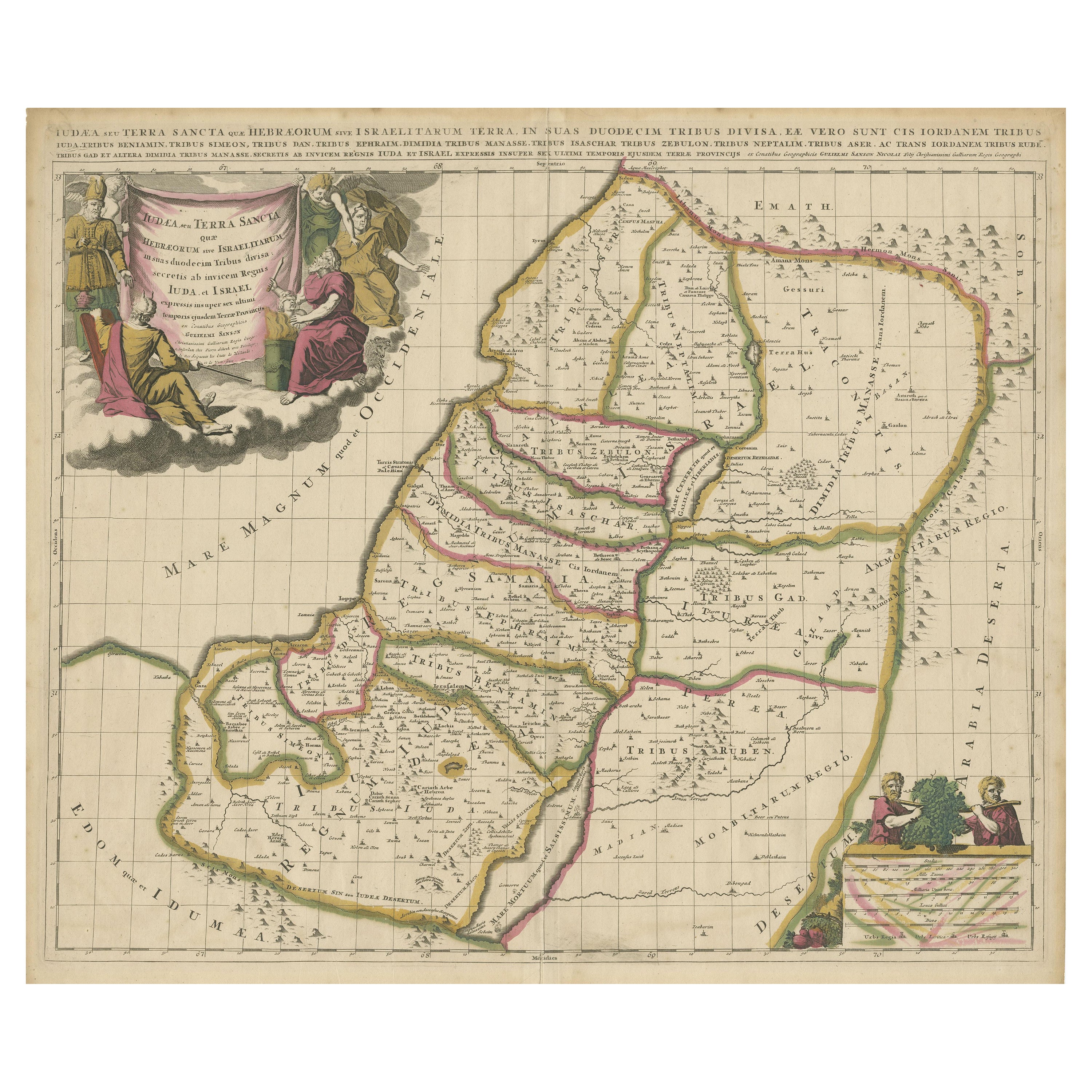
This is a beautiful 1709 map of the Holy Land, titled "Iudaea seu Terra Sancta quae Hebraeorum sive Israelitarum in suas duodecim Tribus divisa," by Guillaume Sanson and Alexis Huber...
Category
Antique Early 1700s Maps
Materials
Paper
Highly Detailed Antique Map of the Holy Land Showing 12 Tribes of Israel, c.1720
Located in Langweer, NL
Antique map titled 'Heylige Land verdeeld in de Twaalf Stammen Israels (..).'
Highly detailed map of the Holy Land divided into 12 tribes of Israel...
Category
Antique 1720s Maps
Materials
Paper

$460 Sale Price
20% Off
Free Shipping
1732 Henri Chatelain Map of the Holy Land Divided Among the Tribes of Israel
Located in Langweer, NL
Title: 1732 Henri Chatelain Map of the Holy Land Divided Among the Tribes of Israel
This exquisite 18th-century map by Henri Chatelain, published in 1732, offers a detailed depict...
Category
Antique 1710s Maps
Materials
Paper

Map of the Holy Land Divided into 12 Tribes, the Travels of Jesus Christ, 1700
Located in Langweer, NL
Antique map titled 'Het Heylige Land verdeeld in de Twaalf Stammen Israels (..)'.
Decorative and detailed map of the Holy Land divided into 12 Tribes, sh...
Category
Antique Early 1700s Maps
Materials
Paper
$469 Sale Price
20% Off
1750 Map of the Holy Land: The Land of Canaan and the Twelve Tribes
Located in Langweer, NL
Carte de la Terre de Canaan ou Terre Promise
Cartographer: Le St. Robert
Date of Publication: 1750
This exquisite 18th-century map, 'Carte de la Terre de Canaan ou Terre Promise', w...
Category
Antique 1750s Maps
Materials
Paper

Antique Map of the Holy Land, Showing the Location of the Various Tribes
Located in Langweer, NL
Antique map titled 'Judaea seu Terra Sancta quae Hebraeorum sive Israelitarum (..)'. Map of The Holy Land, showing the location of the various tribes, in two kingdoms, Judah and Isra...
Category
Antique Early 18th Century Maps
Materials
Paper
$1,150 Sale Price
20% Off
Free Shipping
You May Also Like
Map Holy Land La Terre Sainte Engraved van Loon Published N de Fer 1703 French
Located in BUNGAY, SUFFOLK
La Terre Sainte, The Holy Land, Tiree Des Memoires De M.De.La Rue. Par N. de Fer. Geographe de Sa Majeste Catoliq et de Monseigneur le Dauphin. Avec Privil du Roi 1703
Detailed map of the Holy Land from Nicholas de Fer's L'Atlas Curieux ou le Monde. East is oriented at the top.
MAKER Nicolas de Fer 1646-1720
The French cartographer and engraver, Nicolas de Fer, was a master at creating maps that were works of art. The maps that he published were printed during the Baroque period when the decorative arts were characterized by ornate detail. De Fer’s detailed maps and atlases were valued more for their decorative content than their geographical accuracy.
Nicolas de Fer was born in 1646. His father, Antoine de Fer, owned a mapmaking firm. At the age of twelve, Nicolas was apprenticed to a Parisian engraver named Louis Spirinx. The family business was starting to decline when his father died in 1673. Nicolas de Fer’s mother, Genevieve, took over the business after the death of her husband. In 1687 the business was passed on to Nicolas and the profits increased after he took over the firm. Nicolas de Fer was a prolific cartographer who produced atlases and hundreds of single maps. He eventually became the official geographer to King Louis XIV of France and King Philip V...
Category
Antique Early 1700s French Louis XIV Maps
Materials
Paper

"Nova Barbariae Descriptio", a 17th Century Hand-Colored Map of North Africa
By Johannes Janssonius
Located in Alamo, CA
This original attractive 17th century hand-colored map of North Africa entitled "Nova Barbariae Descriptio" by Johannes Janssonius was published in Paris in 1635. It includes the Med...
Category
Antique Mid-17th Century Dutch Maps
Materials
Paper

Portugal: A Large 17th Century Hand-colored Map by Sanson and Jaillot
By Nicolas Sanson
Located in Alamo, CA
This large hand-colored map entitled "Le Royaume de Portugal et des Algarves Divisee en see Archeveches, Eveches et Territoires Par le Sr Sanson" was originally created by Nicholas S...
Category
Antique 1690s French Maps
Materials
Paper

Southern Greece: A Large 17th C. Hand-colored Map by Sanson and Jaillot
By Nicolas Sanson
Located in Alamo, CA
This large original hand-colored copperplate engraved map of southern Greece and the Pelopponese Peninsula entitled "La Moree Et Les Isles De Zante, Cefalonie, Ste. Marie, Cerigo & C...
Category
Antique 1690s French Maps
Materials
Paper

18th Century Hand-Colored Homann Map of Germany, Including Frankfurt and Berlin
By Johann Baptist Homann
Located in Alamo, CA
An 18th century hand-colored map entitled "Tabula Marchionatus Brandenburgici et Ducatus Pomeraniae quae sunt Pars Septentrionalis Circuli Saxoniae Superioris" by Johann Baptist Homa...
Category
Antique Early 18th Century German Maps
Materials
Paper

1640 Willem Blaeu Map Entitled "Contado di molise et principato vltra, " Ric.a003
By Willem Blaeu
Located in Norton, MA
1640 Willem Blaeu map entitled
"Contado di molise et principato vltra,"
Colored
Ric. a003
Measures: 38 x 49.6 cm and wide margins
DBLAEU.
Cou...
Category
Antique 17th Century Dutch Maps
Materials
Paper

More Ways To Browse
Kohler Antique
Travel Altar
Israel Sword
Carlo Scarpa 1934 Chairs
Christofle Marly
1900 Antique Chairs
Glass Table Italian Round
Alvar Aalto Poster
Geometric Metal Table
Post Modern High Chairs
Vintage Vine Rug
Cancel An Order
Antique Framing Square
Silver Metal Chair
Swedish Kilim
Vintage Scandanavian Chairs
Vintage Tropical Furniture
19th Century Red Glass