Items Similar to 1720 Johann Baptist Homann Map of the Austrian Circle and Surrounding Regions


Want more images or videos?
Request additional images or videos from the seller
1 of 8
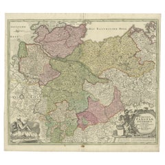
1720 Johann Baptist Homann Map of the Austrian Circle and Surrounding Regions
$736.52
$920.6520% Off
£544.64
£680.8020% Off
€616
€77020% Off
CA$1,019.23
CA$1,274.0420% Off
A$1,134.85
A$1,418.5620% Off
CHF 590.55
CHF 738.1920% Off
MX$13,697.40
MX$17,121.7520% Off
NOK 7,406.08
NOK 9,257.6020% Off
SEK 6,995.51
SEK 8,744.3820% Off
DKK 4,690.87
DKK 5,863.5920% Off
About the Item
"1720 Johann Baptist Homann Map of the Austrian Circle and Surrounding Regions"
Description of the Map:
This map, crafted by the renowned cartographer Johann Baptist Homann around 1720, is titled "Germania Austriaca Complectens S.R.I. Circulum Austriacum ut et Reliquas in Germania." It provides a comprehensive depiction of the Austrian Circle of the Holy Roman Empire and its adjacent regions.
The coverage extends from Heidelberg and the Upper Rhine in the northwest, through large parts of Switzerland, down to Milan in the southwest, encompassing Croatia to the southeast, and stretching to Vienna, Pressburg (modern-day Bratislava), and Prague in the northeast.
- Geographical Scope: The map details a vast area central to the political and cultural landscape of early 18th-century Europe, marking major cities, rivers, and lakes meticulously.
- Artistic Elements: A striking feature of the map is its elaborate title cartouche located in the upper left corner, which includes the coats of arms of the provinces such as Moravia, Silesia, Bohemia, Austria, Tyrolis, Carniola, Stiria, and Carinthia, symbolizing their significance within the Empire.
- Coloration: The map is old colored, meaning that it retains the original hues used during its initial publication, which adds to its historical authenticity and aesthetic value.
Cartographer:
Johann Baptist Homann, born in 1664, was a pivotal figure in German cartography, originally establishing his business in Nuremberg in 1702. After decades of Dutch dominance in mapmaking, Homann's works marked a significant German contribution to European cartography. He was recognized by the Academy of Science in Berlin and continued to influence mapmaking through his publishing house well beyond his death in 1724.
Historical Significance:
This map not only serves as a detailed geographical record but also as a cultural artifact, reflecting the geopolitical dynamics of the region during the early 1700s. It was created during a period when maps were integral to the understanding and administration of territories within the vast and complex structure of the Holy Roman Empire.
Collector's Value:
For collectors, this map is a prized possession due to its detailed cartography, the reputation of its creator, and its excellent preservation of the period's cartographic aesthetics. It is especially valuable for those interested in the history of Central Europe, the art of cartography, and the legacy of the Holy Roman Empire's administrative divisions.
- Dimensions:Height: 21.26 in (54 cm)Width: 24.41 in (62 cm)Depth: 0 in (0.02 mm)
- Materials and Techniques:Paper,Engraved
- Period:1720-1729
- Date of Manufacture:circa 1720
- Condition:Condition: Good, given age. General age-related toning and/or occasional minor defects from handling, mainly around the borders. Vertical fold as issued. Please study scan carefully.
- Seller Location:Langweer, NL
- Reference Number:Seller: BG-13664-61stDibs: LU3054341305972
About the Seller
5.0
Recognized Seller
These prestigious sellers are industry leaders and represent the highest echelon for item quality and design.
Platinum Seller
Premium sellers with a 4.7+ rating and 24-hour response times
Established in 2009
1stDibs seller since 2017
2,587 sales on 1stDibs
Typical response time: <1 hour
- ShippingRetrieving quote...Shipping from: Langweer, Netherlands
- Return Policy
Authenticity Guarantee
In the unlikely event there’s an issue with an item’s authenticity, contact us within 1 year for a full refund. DetailsMoney-Back Guarantee
If your item is not as described, is damaged in transit, or does not arrive, contact us within 7 days for a full refund. Details24-Hour Cancellation
You have a 24-hour grace period in which to reconsider your purchase, with no questions asked.Vetted Professional Sellers
Our world-class sellers must adhere to strict standards for service and quality, maintaining the integrity of our listings.Price-Match Guarantee
If you find that a seller listed the same item for a lower price elsewhere, we’ll match it.Trusted Global Delivery
Our best-in-class carrier network provides specialized shipping options worldwide, including custom delivery.More From This Seller
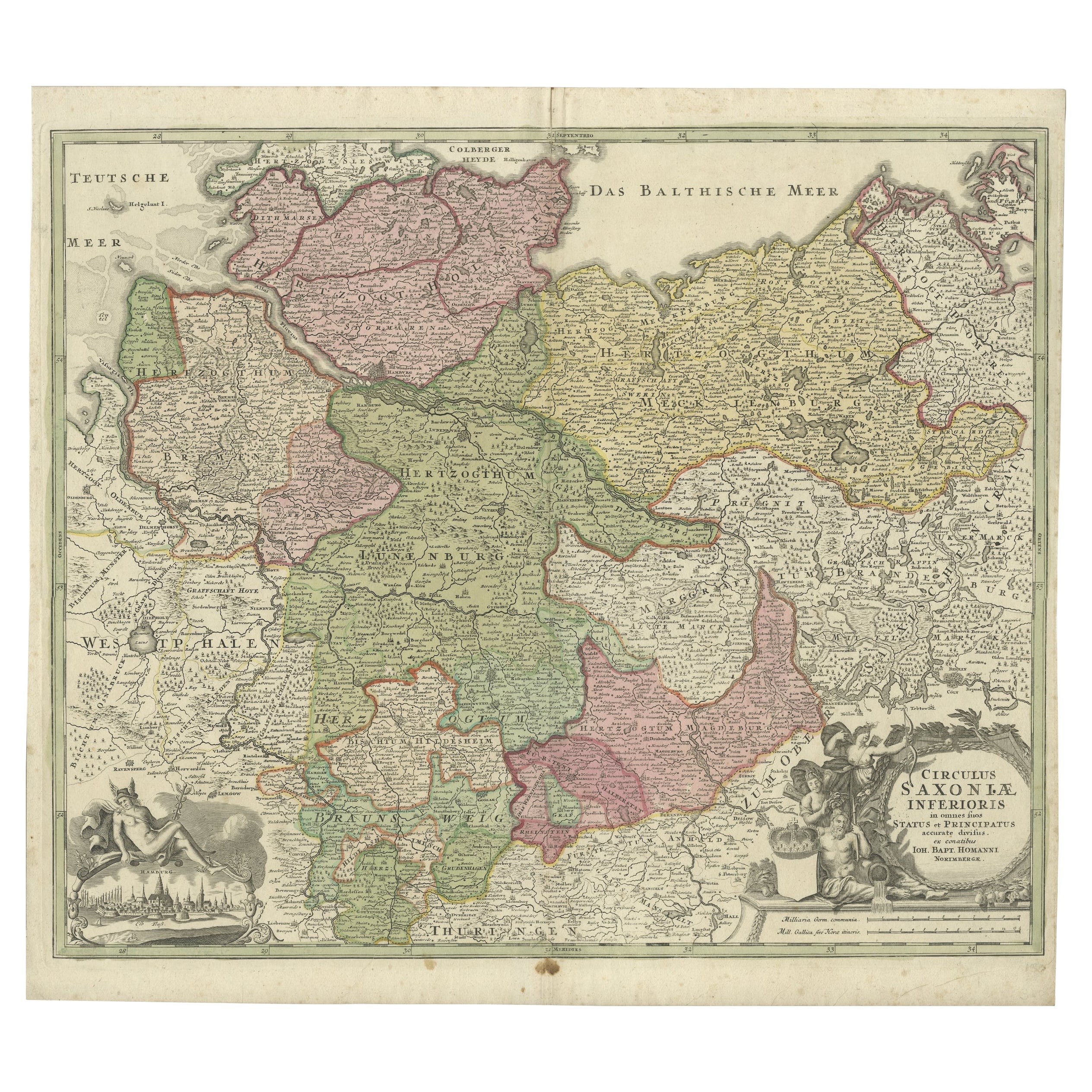
View AllAntique Engraved Map of Saxonia in Northern Germany, ca.1721-1750
Located in Langweer, NL
Duitsland, Sassonia; Johannes Baptist Homann - Circulus Saxoniae Inferioris in omnes suos Status et Principatus accurate divisus ex conatibus -
A large map of Lower Saxony, exten...
Category
Antique Mid-18th Century Maps
Materials
Paper
$813 Sale Price
20% Off
Decorative Antique Map of Austria – Frederick de Wit, Amsterdam c.1690
Located in Langweer, NL
Antique Map of Austria – “Circuli Austriaci pars Septentrionalis” by F. de Wit, c.1670
This finely engraved map, titled “Circuli Austriaci pars Septent...
Category
Antique Late 17th Century Dutch Maps
Materials
Paper

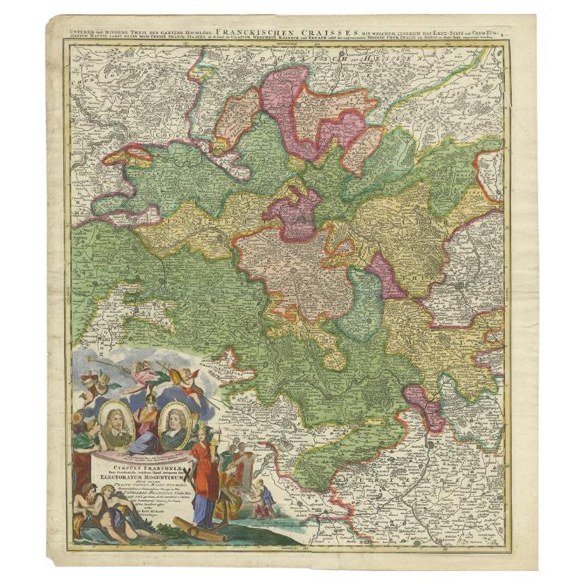
Antique Map of the Circle of Franconia by Homann, c.1703
Located in Langweer, NL
Antique map titled 'Circuli Franconiae pars Occidentalis, exhibes simul integrum fere Electoratum Moguntinum (..)'. Antique map centered on Nuremberg and Bamberg. Extends from the Do...
Category
Antique 18th Century Maps
Materials
Paper

$341 Sale Price
20% Off
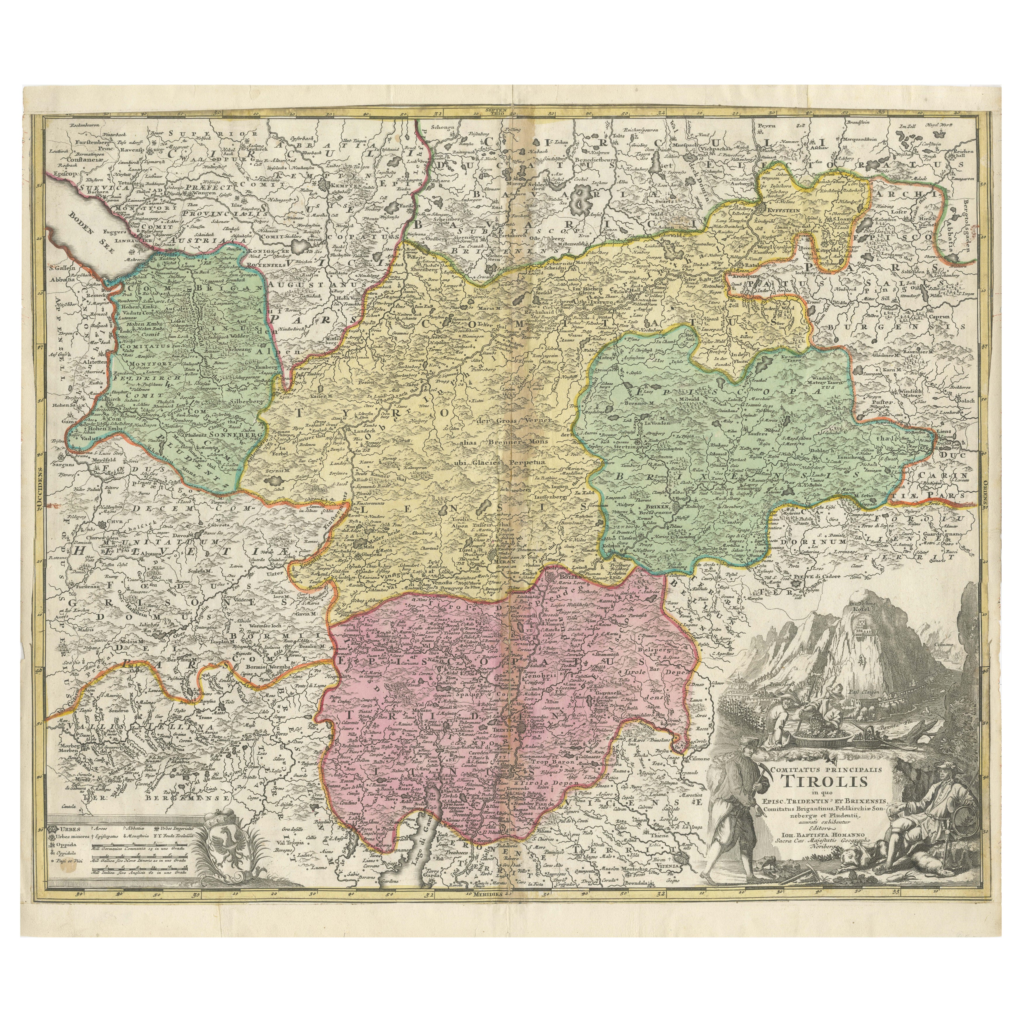
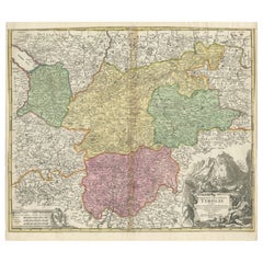
18th-Century Map of Tyrol and Surrounding Regions by Johann Baptist Homann
Located in Langweer, NL
18th-Century Map of Tyrol and Surrounding Regions by Johann Baptist Homann
Description: This striking 18th-century map by Johann Baptist Homann depicts the County of Tyrol (Tirol)...
Category
Antique 1720s Maps
Materials
Paper
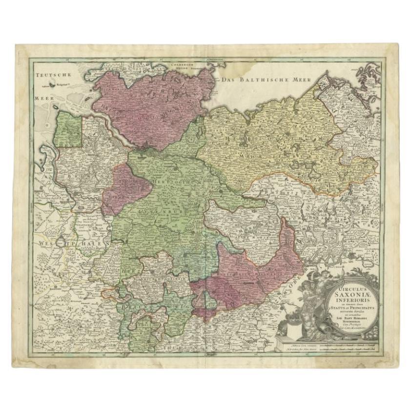
Antique Map of the Lower Saxony Region by Homann, c.1730
By Johann Baptist Homann
Located in Langweer, NL
Antique map titled 'Circulus Saxoniae Inferioris (..)'. Map of the Circle of Lower Saxony. The map covers most of present-day northern Germany, as far south as Göttingen, including m...
Category
Antique 18th Century Maps
Materials
Paper

$180 Sale Price
20% Off
18th-Century Map of Holstein and Surrounding Duchies by Homann Heirs
Located in Langweer, NL
18th-Century Map of Holstein and Surrounding Duchies by Homann Heirs
Description: This finely detailed 18th-century map by the Homann Heirs (Homannische Erben) illustrates the Duc...
Category
Antique 1750s Maps
Materials
Paper

You May Also Like
17th Century Nicolas Visscher Map of Southeastern Europe
Located in Hamilton, Ontario
A beautiful, highly detailed map of southeastern Europe by Nicolas Visscher. Includes regions of Northern Italy (showing the cities Bologna, Padua, and Venice), Bohemia, Austria (sho...
Category
Antique 17th Century Dutch Maps
Materials
Paper

$1,350 Sale Price
38% Off
1752 Vaugoundy Map of Flanders : Belgium, France, and the Netherlands, Ric.a002
Located in Norton, MA
Large Vaugoundy Map of Flanders:
Belgium, France, and the Netherlands
Colored -1752
Ric.a002
Description: This is a 1752 Didier Robert de Vaugondy map of Flanders. The map de...
Category
Antique 17th Century Unknown Maps
Materials
Paper

Antique Colored Belgium Map Flandria Gallica Flanders Henricus Hondius
Located in Dayton, OH
Antique hand colored map of Flanders, Belgium, engraved by Henricus Hondius.
Sans frame - 21.25” x 18”.
Category
Antique 19th Century Renaissance Maps
Materials
Paper

$262 Sale Price
25% Off
1643 Willem&Joan Blaeu Map NW Flanders "Flandriae Teutonicae Pars Prientalior
Located in Norton, MA
1643 Willem and Joan Blaeu map of northwest Flanders, entitled
"Flandriae Teutonicae Pars Prientalior,"
Ric0012
" Authentic" - Map of the northwest Fl...
Category
Antique 17th Century Dutch Maps
Materials
Paper

1790 Thomas Stackhouse Map, Entitled "Russia in Europe, " , Ric.a004
Located in Norton, MA
1790 Thomas Stackhouse map, entitled
"Russia in Europe"
Ric.a004
Stackhouse, Thomas
Russia in Europe [map]
London: T. Stackhouse, 1783. Map. Matted hand-colored copper engraving. Image size: 14.5 x 15.25 inches. Mat size: 22.75 x 23.75 inches. A beautiful example of this map of Eastern Europe...
Category
Antique 17th Century Unknown Maps
Materials
Paper

1853 Map of "Russia in Europe Including Poland" Ric.r016
Located in Norton, MA
Description
Russia in Europe incl. Poland by J Wyld c.1853
Hand coloured steel engraving
Dimension: Paper: 25 cm W x 33 cm H ; Sight: 22 cm W x 28 cm H
Condition: Good ...
Category
Antique 19th Century Unknown Maps
Materials
Paper

More Ways To Browse
Empire Vienna
Tables With Inlaid Wood
World War Table
Antonio Jacobsen
Ariston Chairs
Coffee Tables Europe
Marble Top Dining Tables
Nordiska Argentina
Pink And Black Rug
Black Wooden Chair
Orrefors Embassy
Black Ebonized
Elios Chair
Panache Designs
Plata Lappas
Red Retro Dining Set
Antique Bouquet
Antique Silver Glasses Case