Items Similar to 17th Century Map of Southern Portugal by Sanson – Hand-Colored, 1679

Want more images or videos?
Request additional images or videos from the seller
1 of 10
17th Century Map of Southern Portugal by Sanson – Hand-Colored, 1679
$496.21
£371.94
€420
CA$681.71
A$761.06
CHF 398.79
MX$9,316.16
NOK 5,064.58
SEK 4,775.26
DKK 3,197.19
Shipping
Retrieving quote...The 1stDibs Promise:
Authenticity Guarantee,
Money-Back Guarantee,
24-Hour Cancellation
About the Item
17th Century Map of Southern Portugal by Sanson – Hand-Colored, 1679
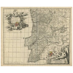
This stunning 1679 map of Portugal offers a captivating glimpse into the past, showcasing the country's geography as it was understood over three centuries ago. Spanning the entire western coast of the Iberian Peninsula, the map meticulously details regions such as Entre Douro e Minho, Beira, Estremadura, Alentejo, and the Algarve, each delineated with vibrant yellow and green borders. The Atlantic Ocean, labeled as "Oceano de Portugal" and "Tugal," frames the western edge, while the Gulf of Cadiz graces the southern boundary, adding a nautical allure to the composition. Intricate place names like Lisbon, Setubal, and Evora are scattered across the landscape, accompanied by a network of rivers, mountains, and towns, all rendered in delicate hand-colored lines and shading.
What makes this print particularly intriguing is its historical context and artistic execution. Created in an era when cartography was both a science and an art form, the map reflects the knowledge and exploration of the time, with some regions depicted with a charmingly approximate accuracy. The ornate cartouche in the upper right corner, adorned with a decorative drape and title "Parte Meridional do Reyno de Portugal," serves as a focal point, hinting at the map's royal patronage and its purpose as both a functional tool and a decorative piece. Red dots marking key locations add a touch of visual interest, drawing the eye across the terrain.
The map depicts the southern portion of Portugal, including:
Lisbon (Lisbonne) and the surrounding regions like Setúbal, Alentejo (ALEN), and the Ribatejo.
The Algarve region at the bottom, labeled "Reino do Algarve".
Border regions of Spain such as Andalusia and Extremadura.
Major rivers like the Tejo (Tagus) and Guadiana are prominently shown.
Cities such as Évora, Beja, Faro, Tavira, and Portalegre are labeled.
Coastal features like Cabo de São Vicente and Golfo de Cádiz are identified.
For a potential buyer, this map is a treasure trove of historical insight and aesthetic appeal. It offers a window into 18th-century Portugal, a period of maritime prowess and cultural richness, making it an ideal addition to a collection of antique maps or a study of European history. The aged parchment texture, combined with the hand-colored details, lends an authentic antique charm that modern reproductions struggle to replicate. Whether displayed in a study, library, or gallery, this map promises to spark conversations and admiration, blending educational value with timeless elegance.
Condition Summary
The print is in fair condition for its age, with some expected wear. There are no significant visible tears or losses, but a weaker area has been supported with archival tape on the reverse. The hand-colored elements remain vivid, and the text is legible, preserving the map's historical integrity.
Framing Tips
To preserve and showcase this print effectively, use acid-free matting and backing to protect the paper from further deterioration. A simple, elegant wooden frame in a neutral tone like walnut or oak will complement the map's antique style without overpowering it. Ensure the frame size allows for a generous border around the map to highlight its detailed edges and cartouche. Hang the print in a location away from direct sunlight and humidity to maintain its condition over time.
- Dimensions:Height: 16.74 in (42.5 cm)Width: 22.45 in (57 cm)Depth: 0.01 in (0.2 mm)
- Materials and Techniques:Paper,Engraved
- Place of Origin:
- Period:Late 17th Century
- Date of Manufacture:1679
- Condition:The print is in fair condition for its age, with some expected wear. There are no significant visible tears or losses, but a weaker area has been supported with archival tape on the reverse. The hand-colored elements remain vivid.
- Seller Location:Langweer, NL
- Reference Number:Seller: BG-14068-21stDibs: LU3054345401102
About the Seller
5.0
Recognized Seller
These prestigious sellers are industry leaders and represent the highest echelon for item quality and design.
Platinum Seller
Premium sellers with a 4.7+ rating and 24-hour response times
Established in 2009
1stDibs seller since 2017
2,511 sales on 1stDibs
Typical response time: <1 hour
- ShippingRetrieving quote...Shipping from: Langweer, Netherlands
- Return Policy
Authenticity Guarantee
In the unlikely event there’s an issue with an item’s authenticity, contact us within 1 year for a full refund. DetailsMoney-Back Guarantee
If your item is not as described, is damaged in transit, or does not arrive, contact us within 7 days for a full refund. Details24-Hour Cancellation
You have a 24-hour grace period in which to reconsider your purchase, with no questions asked.Vetted Professional Sellers
Our world-class sellers must adhere to strict standards for service and quality, maintaining the integrity of our listings.Price-Match Guarantee
If you find that a seller listed the same item for a lower price elsewhere, we’ll match it.Trusted Global Delivery
Our best-in-class carrier network provides specialized shipping options worldwide, including custom delivery.More From This Seller
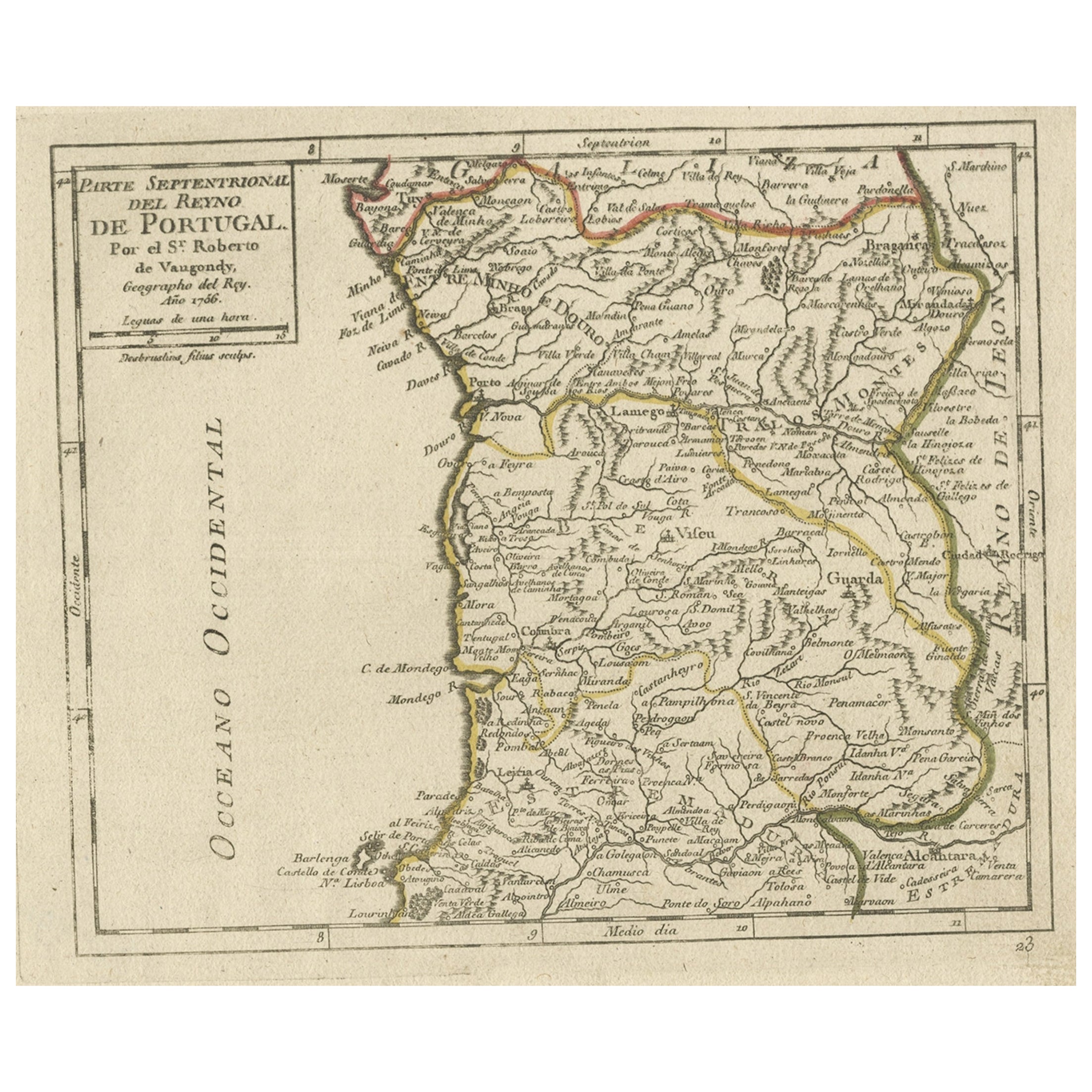
View AllAntique Hand-Colored Map of Northern Portugal, 1756
Located in Langweer, NL
Antique map Portugal titled 'Parte Sepentrional del Reyno de Portugal'.
Antique map of Northern Portugal. This map originates from 'Atlas Port...
Category
Antique 1750s Maps
Materials
Paper
$170 Sale Price
20% Off
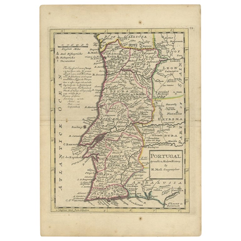
Antique Map of Portugal by Moll, 1727
Located in Langweer, NL
Antique map Portugal titled 'Portugal Agreeable to Modern History'. Detailed map of Portugal showing major routes, waterways, arch bishoprics, bis...
Category
Antique 18th Century Maps
Materials
Paper
$187 Sale Price
20% Off
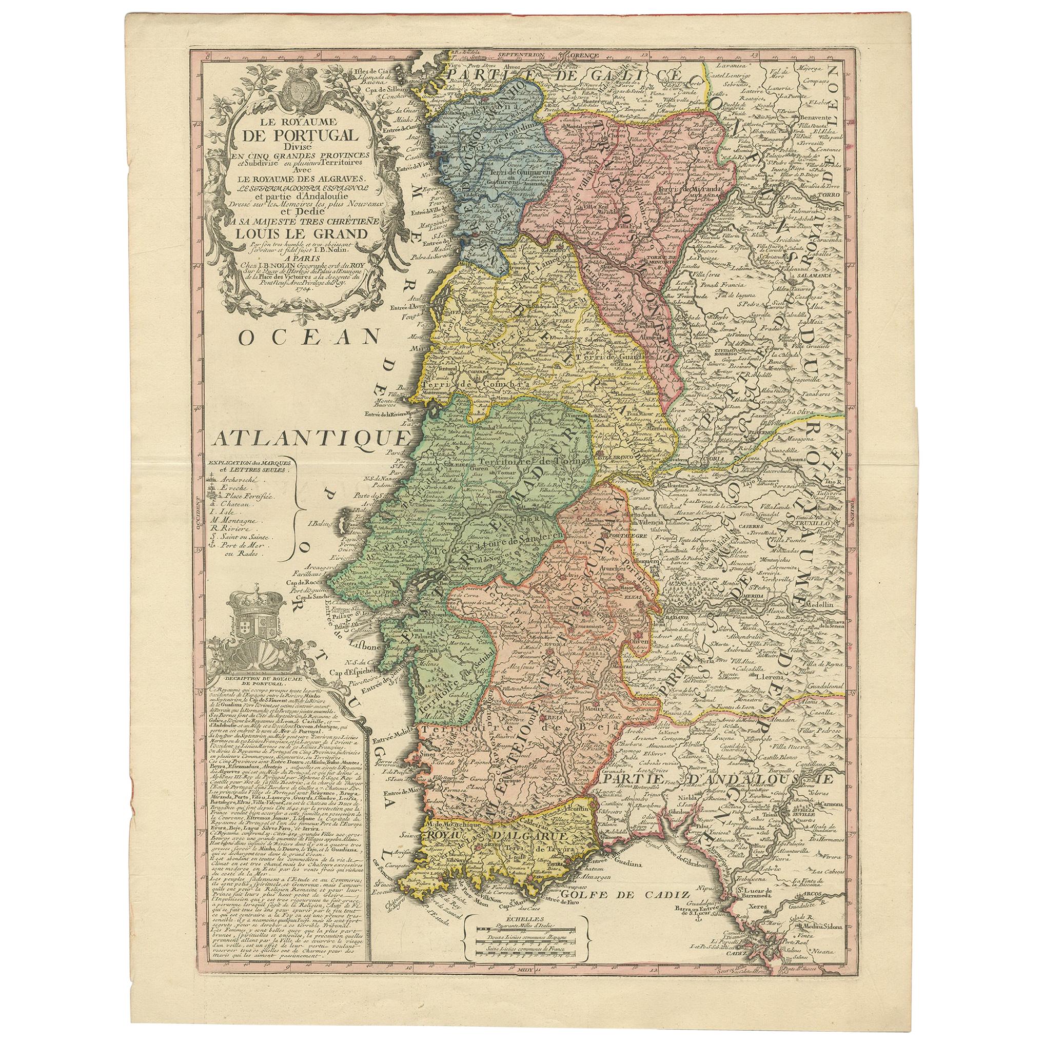
Antique Map of Portugal by Nolin '1704'
Located in Langweer, NL
Antique map titled 'Le Royaume de Porutgal divisé en cinq grandes Provinces (..)'. Rare and very decorative map of Portugal. It shows the territory of ...
Category
Antique Early 18th Century Maps
Materials
Paper

$803 Sale Price
20% Off
Antique Map of Portugal by P. Schenk, circa 1700
Located in Langweer, NL
Antique map titled 'Portugalliae et Algarbia'. Striking example of Schenk's rare map of Portugal, with the coats of arms of Portugal, Algarbia and a Spanish sailing vessell in the ca...
Category
Antique Early 18th Century Maps
Materials
Paper

$817 Sale Price
20% Off
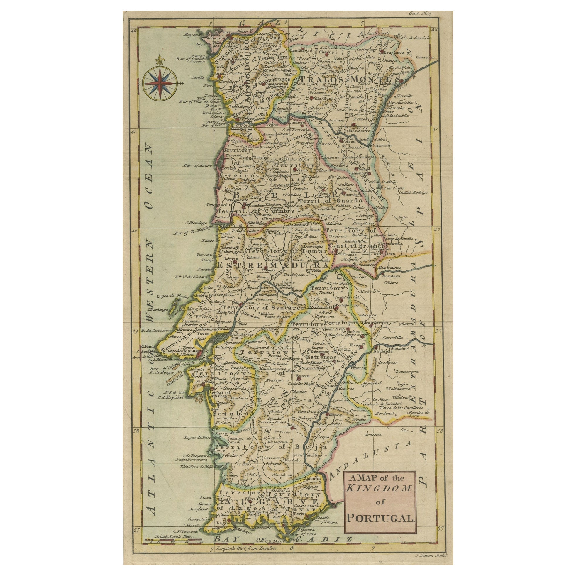
Detailed Antique Map of Portugal, Published for the 'Gentleman's Magazine', 1758
Located in Langweer, NL
Antique map Portugal titled 'A Map of the Kingdom of Portugal'.
Detailed map of Portugal, published for the 'Gentleman's Magazine'.
Artist...
Category
Antique 1750s Maps
Materials
Paper
$453 Sale Price
20% Off
Antique Map of Portugal by J. De Ram, circa 1680
Located in Langweer, NL
A detailed map of Portugal. Embellished with beautiful cartouche, sailing vessels and many putti. Very rare edition by J. de Ram, circa 1680.
Category
Antique Late 17th Century Maps
Materials
Paper
$765 Sale Price
20% Off
You May Also Like
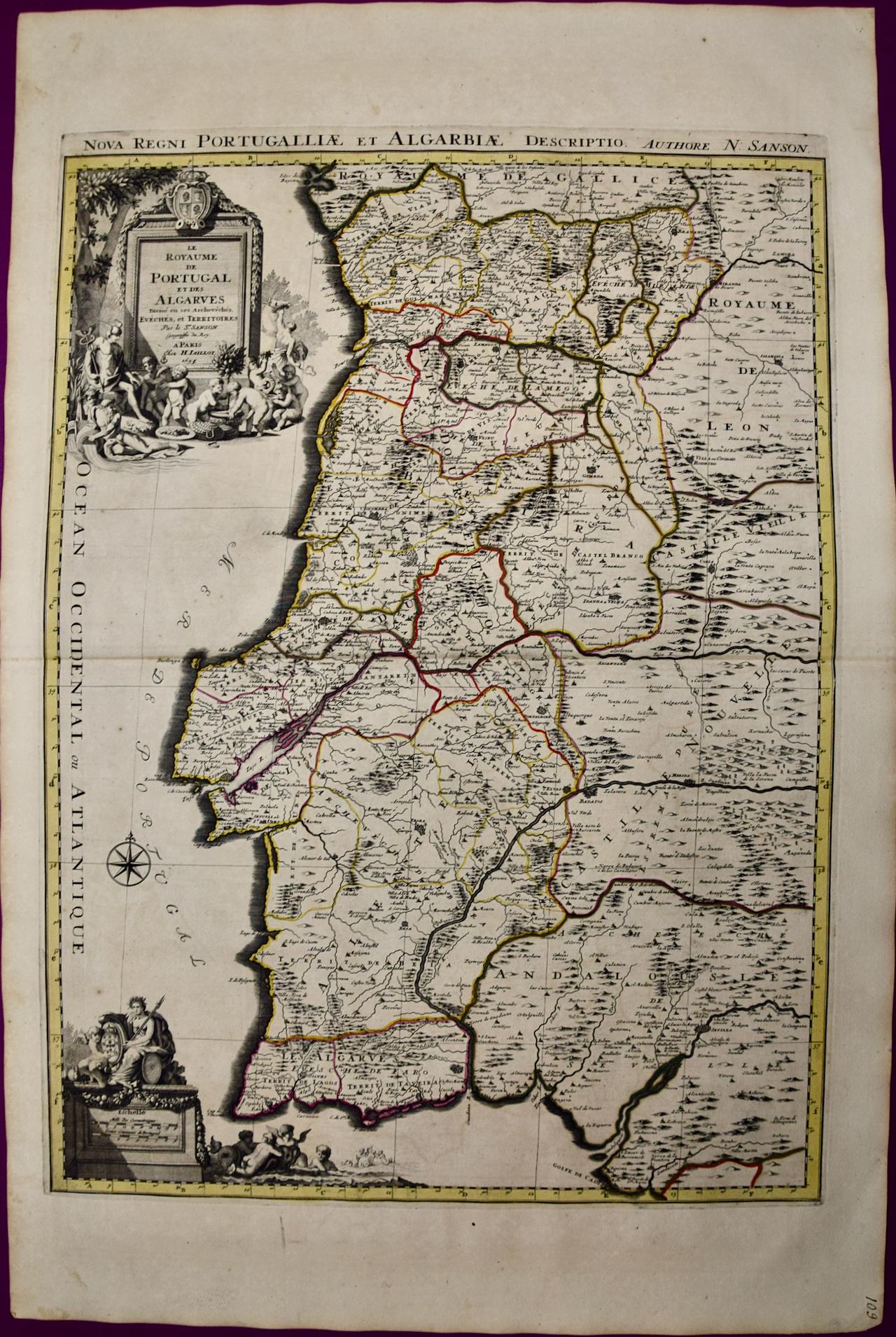
Portugal: A Large 17th Century Hand-colored Map by Sanson and Jaillot
By Nicholas Sanson d'Abbeville
Located in Alamo, CA
This large hand-colored map entitled "Le Royaume de Portugal et des Algarves Divisee en see Archeveches, Eveches et Territoires Par le Sr Sanson" was originally created by Nicholas S...
Category
1690s Landscape Prints
Materials
Engraving

18th Century Hand Colored Map of Spain and Portugal by Visscher
By Nicolaes Visscher II
Located in Alamo, CA
This is an early 18th century map of Spain and Portugal, with attractive original hand-coloring, entitled "Hispaniae et Portugalliae Regna per Nicolaum Visscher cum Privilegio Ordinu...
Category
Antique Early 18th Century Dutch Maps
Materials
Paper

Portugal: A Large 17th Century Hand-colored Map by Sanson and Jaillot
By Nicolas Sanson
Located in Alamo, CA
This large hand-colored map entitled "Le Royaume de Portugal et des Algarves Divisee en see Archeveches, Eveches et Territoires Par le Sr Sanson" was originally created by Nicholas S...
Category
Antique 1690s French Maps
Materials
Paper

Spain and Portugal: A Hand-colored 17th/18th Century Map by Visscher
By Nicolaus Visscher
Located in Alamo, CA
This is an early 18th century map of Spain and Portugal, with attractive original hand-coloring, entitled "Hispaniae et Portugalliae Regna per Nicolaum Visscher cum Privilegio Ordinum Hollandiae et Westfrisiae" first published by Nicolaes Visscher II (1649-1702) in 1688, and later re-published from Visscher's original copper plate by Peter Schenk, Junior in Amsterdam in 1725. The cartouche in the right lower corner depicts a coat of arms representing one combined kingdom of Spain and Portugal before their break-up. Putti hold up the coat-of-arms of Phillip II on the right and a queen reaches for it on the left. There is a scale cartouche in the lower left corner surmounted by two putti and a wheel. This is an outstanding depiction of the Iberian peninsula, showing Spain and Portugal and Balearic Islands. The map includes portions of North Africa and the Strait of Gibralter.
This copperplate engraved map is presented in a cream-colored mat. It is printed on fine chain-linked, laid paper. The mat measures 26.5" high by 30" wide and the sheet measures 21.75" high by 26.375" wide. There is a central fold, as issued. The lower portion of the fold is reinforced on the verso. There is a small paper defect at the lower edge of the fold and another at the edge of the right corner, as well as a few small tears along the lower edge; none affecting the map and all covered by the mat. There are a few small faint spots in the upper margin and on the left. The map is otherwise in very good condition.
The Visscher family were one of the great art and cartographic printing families of the 17th century. Begun by Claes Jansz Visscher...
Category
Late 17th Century Other Art Style Landscape Prints
Materials
Engraving

Original Antique Map of Spain and Portugal, circa 1790
Located in St Annes, Lancashire
Super map of Spain and Portugal
Copper plate engraving by A. Bell
Published, circa 1790.
Unframed.
Category
Antique 1790s English Other Maps
Materials
Paper

Map of Spain and Portugal - Etching by Pierre François Tardieu - 1837
Located in Roma, IT
Map of Spain and Portugal is an Etching realized by Pierre François Tardieu in 1837.
Good conditions.
The artwork is realized in a well-balanced composition. the artwork and belong...
Category
1830s Modern Figurative Prints
Materials
Lithograph

More Ways To Browse
17th Century Portuguese
17th Century Portuguese Furniture
Spanish Frame 17th Century
French Matting
18th Century Art Tools
Lisbon Antique
Spanish Andalusia
Styles Of Antique Desks
Black And White Coffee Table
Curved Velvet Couch
Velvet Curved Sofa
Wood Round Coffee Tables
Antique Paper Flowers
Oak Brutalist
Used College Furniture
Wood Minimalist Chair
2002 Lamp
Antique Imperial Furniture