Items Similar to 1857 Map of Southern South America – Argentina, Chile, Rio de Janeiro


Want more images or videos?
Request additional images or videos from the seller
1 of 10
1857 Map of Southern South America – Argentina, Chile, Rio de Janeiro
$459.66
£346.22
€390
CA$633.89
A$712.15
CHF 372.10
MX$8,692.15
NOK 4,724.59
SEK 4,447.21
DKK 2,968.53
About the Item
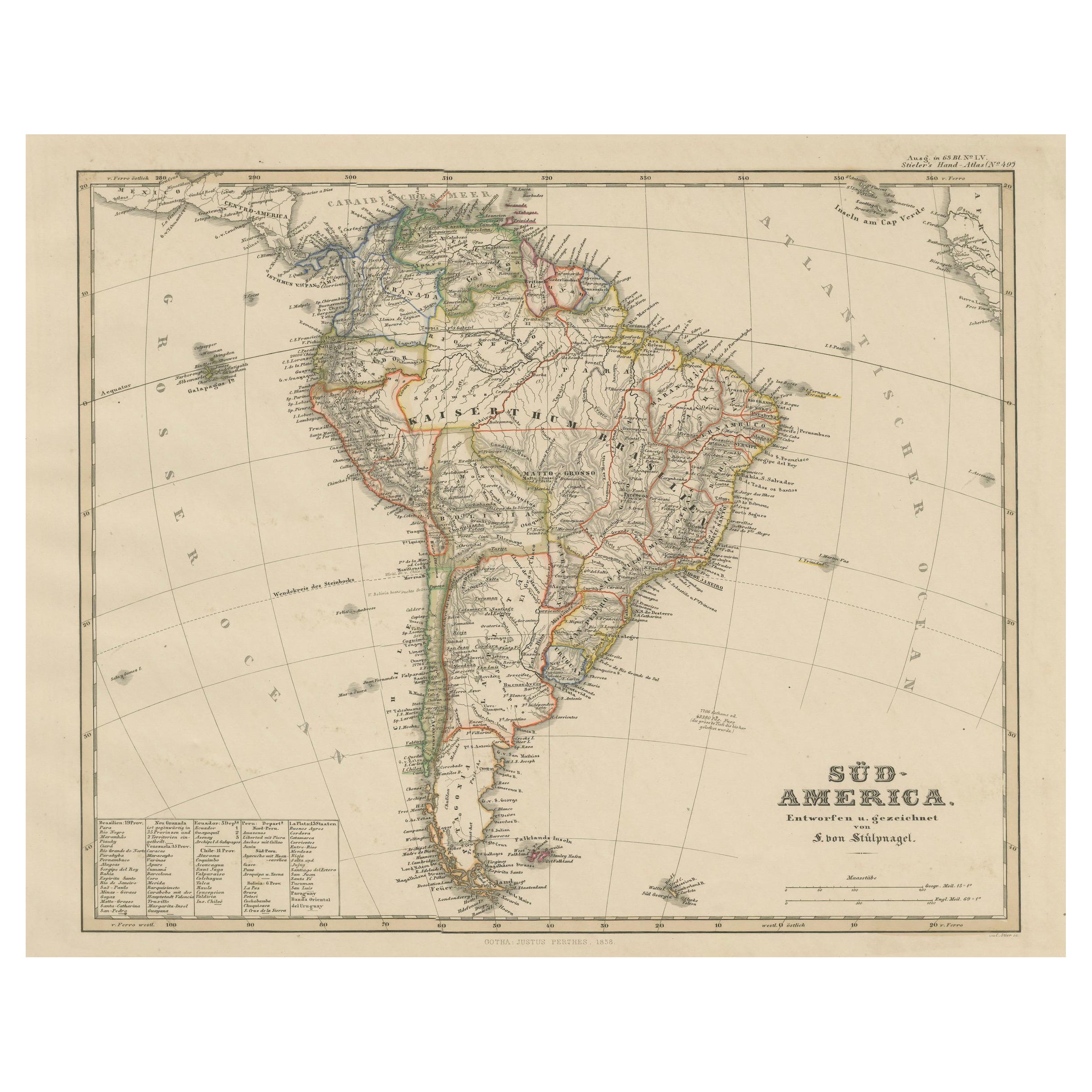
1857 Map of Southern South America – Argentina, Chile, Rio de Janeiro
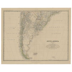
Original antique map titled “Der Südliche Theil von Süd-America” (The Southern Part of South America), published by Justus Perthes in Gotha, 1857. This finely engraved map shows the southern part of South America, including Argentina, Chile, Uruguay, Paraguay, and southern Brazil. It also features two inset maps of the Bay and City of Rio de Janeiro.
Drawn by V. von Stülpnagel, the map presents a wealth of detail including cities such as Buenos Aires, Santiago, Montevideo, and Valparaíso, and geographical features such as the Andes Mountains, rivers, capes, and islands. The southern cone, including Patagonia and Tierra del Fuego, is accurately delineated, along with the Falkland Islands.
The two inset maps in the lower right corner provide a closer look at:
1. The Bay of Rio de Janeiro, showing its dramatic harbor and surrounding geography.
2. The city of Rio de Janeiro itself, including streets, fortifications, and key structures.
This map was part of a two-sheet representation of South America and is the southern half of the full set. Printed in copperplate and hand-colored to indicate territorial boundaries, it reflects the high-quality cartographic work typical of Justus Perthes publications.
Condition report:
Very good condition with only light age toning. A few minor spots in the margins. Strong print quality and original hand-coloring remain crisp and clear.
Framing suggestions:
This map would look excellent in a simple black or dark wooden frame with a soft off-white mat to highlight the engraving and fine line work. Pairs beautifully with the northern sheet for a full continental view.
Technique: Copperplate engraving with original hand-coloring
Maker: Justus Perthes / V. von Stülpnagel, Gotha, 1857
- Dimensions:Height: 14.77 in (37.5 cm)Width: 17.88 in (45.4 cm)Depth: 0.01 in (0.2 mm)
- Materials and Techniques:Paper,Engraved
- Place of Origin:
- Period:
- Date of Manufacture:1858
- Condition:Very good condition with only light age toning. A few minor spots in the margins. Strong print quality and original hand-coloring remain crisp and clear.
- Seller Location:Langweer, NL
- Reference Number:Seller: BG-05552-561stDibs: LU3054346119052
About the Seller
5.0
Recognized Seller
These prestigious sellers are industry leaders and represent the highest echelon for item quality and design.
Platinum Seller
Premium sellers with a 4.7+ rating and 24-hour response times
Established in 2009
1stDibs seller since 2017
2,533 sales on 1stDibs
Typical response time: <1 hour
- ShippingRetrieving quote...Shipping from: Langweer, Netherlands
- Return Policy
Authenticity Guarantee
In the unlikely event there’s an issue with an item’s authenticity, contact us within 1 year for a full refund. DetailsMoney-Back Guarantee
If your item is not as described, is damaged in transit, or does not arrive, contact us within 7 days for a full refund. Details24-Hour Cancellation
You have a 24-hour grace period in which to reconsider your purchase, with no questions asked.Vetted Professional Sellers
Our world-class sellers must adhere to strict standards for service and quality, maintaining the integrity of our listings.Price-Match Guarantee
If you find that a seller listed the same item for a lower price elsewhere, we’ll match it.Trusted Global Delivery
Our best-in-class carrier network provides specialized shipping options worldwide, including custom delivery.More From This Seller
View AllAntique Map of South America by Lapie '1842'
Located in Langweer, NL
Antique map titled 'Carte Générale de l'Amérique Meridionale'. Map of South America. This map originates from 'Atlas universel de géographie ancienne et moderne (..)' by Pierre M. La...
Category
Antique Mid-19th Century Maps
Materials
Paper

$565 Sale Price
20% Off
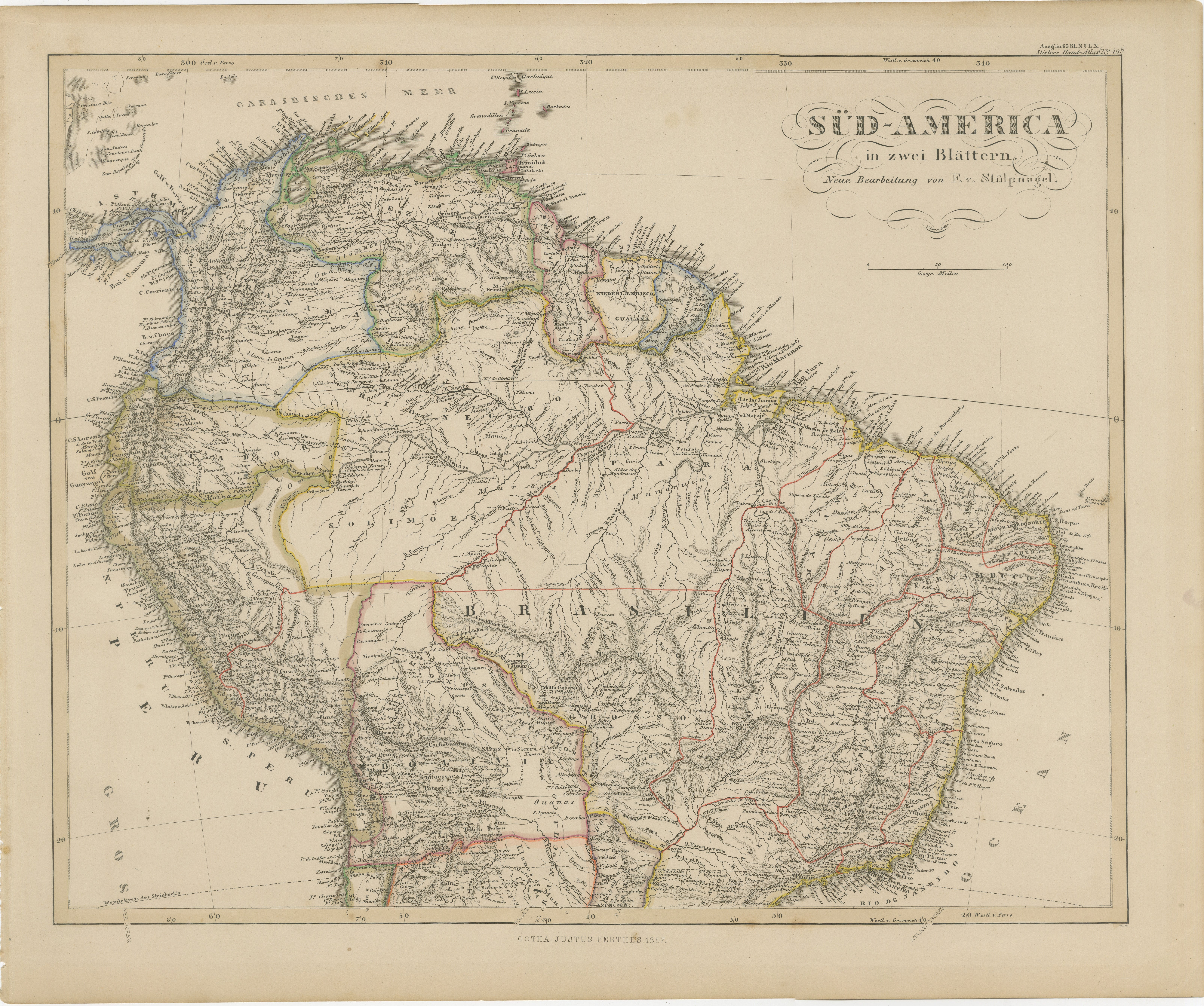
1857 Map of Northern South America – Brazil, Colombia, Peru by Stülpnagel
Located in Langweer, NL
1857 Map of Northern South America – Brazil, Colombia, Peru by Stülpnagel
Antique map titled “Süd-America in zwei Blättern” (South America in Two Sheets), newly edited by V. v. Stül...
Category
Antique Mid-19th Century German Maps
Materials
Paper

Historic 1858 Map of South America – Pre-Border Consolidation
Located in Langweer, NL
Antique Map of South America – Stülpnagel Engraving Published by Perthes, 1858
Detailed 19th-century engraved map titled "Süd-America", designed and drawn by F. von Stülpnagel and p...
Category
Antique Mid-19th Century German Maps
Materials
Paper

Antique Map of South America, Southern Part, 1882
Located in Langweer, NL
Antique map titled 'South America'. Old map of South America. This map originates from 'The Royal Atlas of Modern Geography, Exhibiting, in a Series of Entirely Original and Authenti...
Category
Antique 19th Century Maps
Materials
Paper
Antique Map of South America by W. G. Blackie, 1859
Located in Langweer, NL
Antique map titled 'South America'. Original antique map of South America. This map originates from ‘The Imperial Atlas of Modern Geography’. Published by W. G. Blackie, 1859.
Category
Antique Mid-19th Century Maps
Materials
Paper

$235 Sale Price
20% Off
Interesting Original Antique Map of South America, 1822
Located in Langweer, NL
Antique map titled 'South America'.
Map of South America with attractive topography, surrounded on three sides by text on the history, geography, and economy of the continent. Sh...
Category
Antique 19th Century Maps
Materials
Paper

You May Also Like
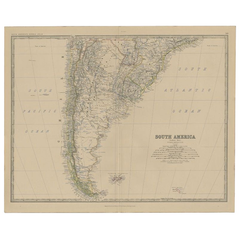
South America, Eastern Part. Century Atlas antique vintage map
Located in Melbourne, Victoria
'The Century Atlas. South America. Eastern Part'
Original antique map, 1903.
Inset map 'Rio de Janeiro and Vicinity'.
Central fold as issued. Map name and number printed on the rev...
Category
Early 20th Century Victorian More Prints
Materials
Lithograph

South America, North-West Part. Century Atlas antique vintage map
Located in Melbourne, Victoria
'The Century Atlas. South America, North-West Part'
Original antique map, 1903.
Central fold as issued. Map name and number printed on the reverse corners.
Sheet 40cm by 29.5cm.
Category
Early 20th Century Victorian More Prints
Materials
Lithograph

Original Antique Decorative Map of South America-West Coast, Fullarton, C.1870
Located in St Annes, Lancashire
Great map of Chili, Peru and part of Bolivia
Wonderful figural border
From the celebrated Royal Illustrated Atlas
Lithograph. Original color.
Published by Fullarton, Edi...
Category
Antique 1870s Scottish Maps
Materials
Paper

Original Antique Map of South America. C.1780
Located in St Annes, Lancashire
Great map of South America
Copper-plate engraving
Published C.1780
Two small worm holes to left side of map
Unframed.
Category
Antique Early 1800s English Georgian Maps
Materials
Paper

Carte du Bresil, antique 1860s engraved map of Brazil
Located in Melbourne, Victoria
'Carte du Bresil'
Engraving with original outline colouring, circa 1860, by Alexandre Vuillemin, published in Paris.
31cm by 41cm (sheet)
21.5cm by 31.5cm (image)
Category
Late 19th Century Victorian More Prints
Materials
Lithograph

Charte von Sud-America (Map of South America) - Etching with Hand-Drawn Outlines
Located in Soquel, CA
Map of south America, engraved by Franz Pluth (Czech, 1800-1871), from the book "Neueste Länder - und Völkerkunde, ein geographisches Lesebuch für alle Stände" by Linder, F. L. (Prag...
Category
1820s Other Art Style More Prints
Materials
Paper, Printer's Ink, Etching
