Items Similar to 1888 Antique Map of Oregon – Railroads, Counties & Native Indian Reservations

Want more images or videos?
Request additional images or videos from the seller
1 of 10
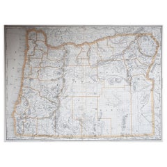
1888 Antique Map of Oregon – Railroads, Counties & Native Indian Reservations
$567.44
£423.41
€480
CA$789.52
A$883.49
CHF 459.60
MX$10,645.43
NOK 5,786.20
SEK 5,466.99
DKK 3,654.60
About the Item
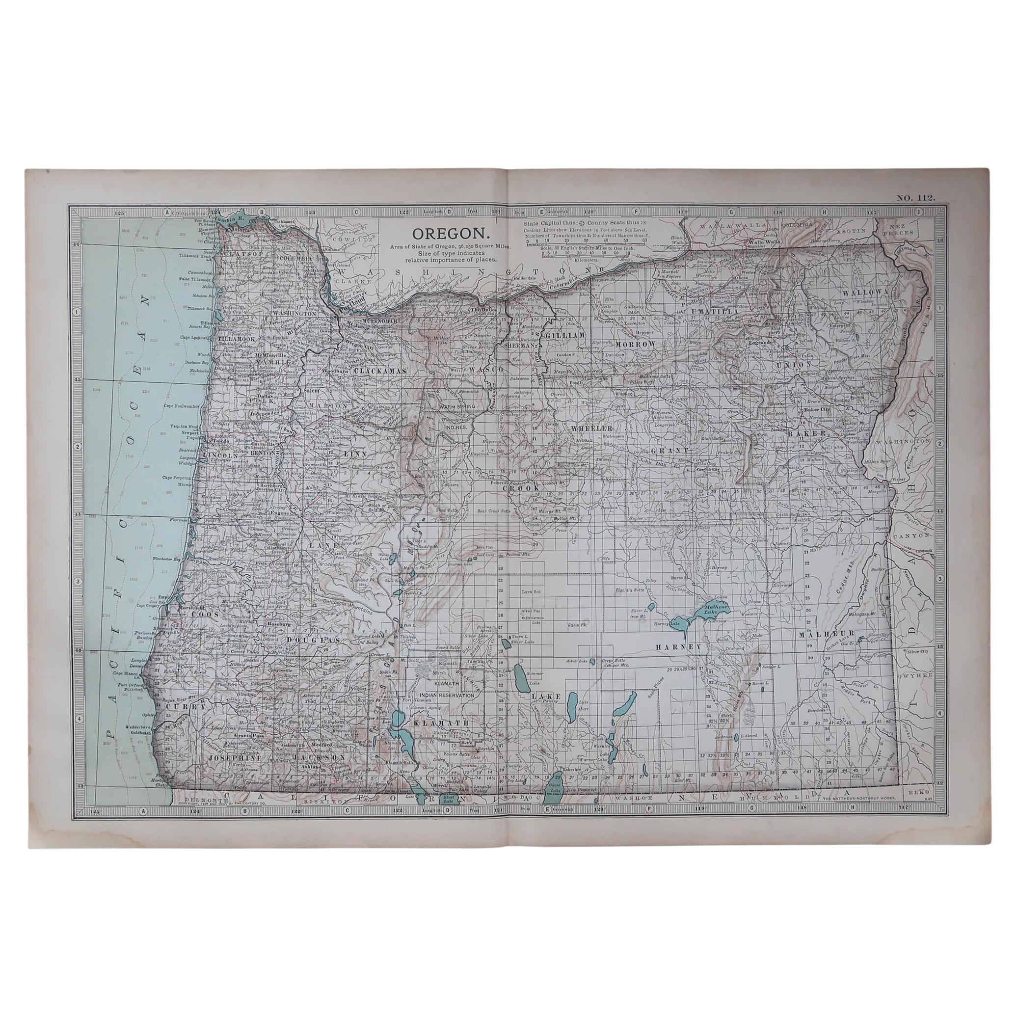
Antique Map of Oregon – Railroads, Indian Reservations & Counties, 1888
This antique engraved map presents the state of Oregon in 1888, a time when the Pacific Northwest was rapidly expanding under the influence of railroads, agriculture, and settlement. Published by Rand, McNally & Co. in Chicago for their Improved Indexed Business Atlas and Shippers Guide, it provides a detailed view of Oregon’s counties, towns, transportation routes, and natural geography just three decades after statehood in 1859.
The map highlights the development of railroads, depicted in red and blue lines. Key routes include the Oregon & California Railroad running south from Portland through the Willamette Valley and the Oregon Railway & Navigation Company line following the Columbia River eastward toward the Idaho border. These routes connected Portland—the economic and shipping center of the state—to interior farming communities and to markets across the United States. The importance of Portland, Salem (the capital), and Astoria are emphasized, along with smaller but growing towns like Eugene, Albany, and The Dalles.
Equally significant are the Native American reservations clearly marked, such as the Warm Spring Indian Reservation and the Klamath Indian Reservation. Their presence on the map underscores the ongoing process of displacement and cultural negotiation that characterized Oregon in the late 19th century. Counties including Multnomah, Marion, Lane, Jackson, Umatilla, Baker, and Wasco are well defined, reflecting the administrative structure of the state during this period. Natural features are also carefully noted, including the Cascade Range, Crater Lake, the Columbia River, and Oregon’s rugged Pacific coastline.
This map captures a transitional moment in Oregon’s history. Timber and fishing industries were thriving, agriculture in the Willamette Valley was flourishing, and mining operations in eastern Oregon continued to draw settlers. The expansion of the railroads during the 1880s was instrumental in integrating Oregon’s economy with the rest of the nation, fueling population growth and new opportunities.
Printed as an engraving, the map displays the crisp, clear detail for which Rand McNally was renowned. It was designed both as a practical business and shipping reference and as a promotional tool highlighting Oregon’s accessibility and resources.
Condition summary: Good condition with only minor age-related toning. Some faint foxing and handling marks in the margins, but no major tears or repairs. Paper remains strong, with a clear plate impression and excellent readability.
Framing tips: A walnut or oak frame would enhance the antique feel of this map, while a black frame with a cream or parchment-colored mount will emphasize the fine engraved detail. A double mat, perhaps ivory with a green accent, can draw attention to Oregon’s natural landscapes and rich geography.
Technique: Engraving
Maker: Rand, McNally & Co., Chicago, 1888
- Dimensions:Height: 14.18 in (36 cm)Width: 20.67 in (52.5 cm)Depth: 0.01 in (0.2 mm)
- Materials and Techniques:Paper,Engraved
- Place of Origin:
- Period:
- Date of Manufacture:1888
- Condition:Condition summary: Good condition with only minor age-related toning. Some faint foxing and handling marks in the margins, but no major tears or repairs. Paper remains strong, with a clear plate impression and excellent readability.
- Seller Location:Langweer, NL
- Reference Number:Seller: BG-12794-611stDibs: LU3054346342432
About the Seller
5.0
Recognized Seller
These prestigious sellers are industry leaders and represent the highest echelon for item quality and design.
Platinum Seller
Premium sellers with a 4.7+ rating and 24-hour response times
Established in 2009
1stDibs seller since 2017
2,587 sales on 1stDibs
Typical response time: <1 hour
- ShippingRetrieving quote...Shipping from: Langweer, Netherlands
- Return Policy
Authenticity Guarantee
In the unlikely event there’s an issue with an item’s authenticity, contact us within 1 year for a full refund. DetailsMoney-Back Guarantee
If your item is not as described, is damaged in transit, or does not arrive, contact us within 7 days for a full refund. Details24-Hour Cancellation
You have a 24-hour grace period in which to reconsider your purchase, with no questions asked.Vetted Professional Sellers
Our world-class sellers must adhere to strict standards for service and quality, maintaining the integrity of our listings.Price-Match Guarantee
If you find that a seller listed the same item for a lower price elsewhere, we’ll match it.Trusted Global Delivery
Our best-in-class carrier network provides specialized shipping options worldwide, including custom delivery.More From This Seller
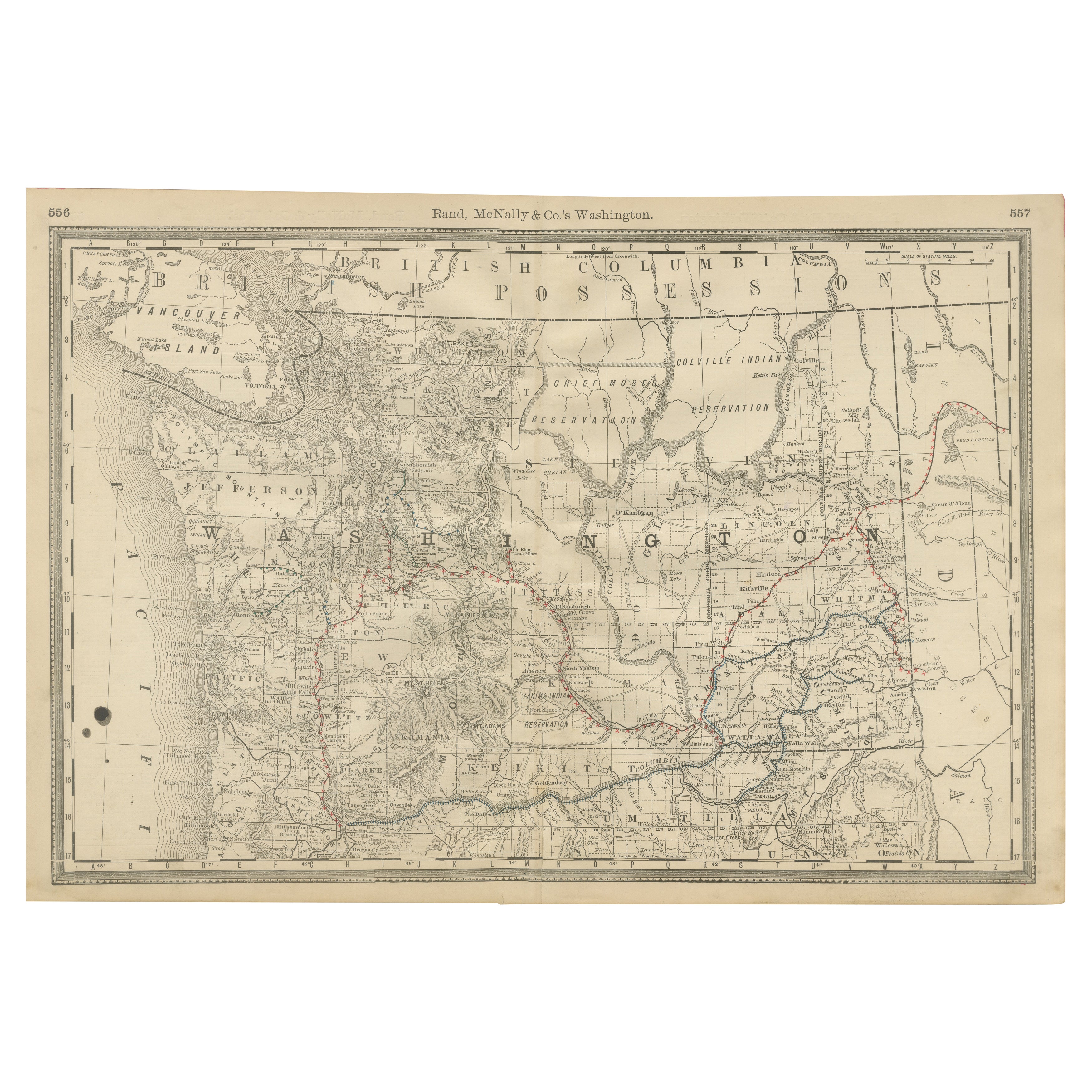
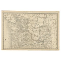
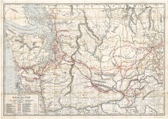
View AllWashington Map 1888 – Antique Railroads, Indian Reservations & Counties
Located in Langweer, NL
Antique Map of Washington – Railroads, Counties & Indian Reservations, 1888
This original engraved map shows the Territory of Washington in 1888, a historically important moment jus...
Category
Antique Late 19th Century American Maps
Materials
Paper
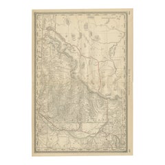
1888 Idaho Map – The Gem State’s Railroads, Mining Camps & Counties
Located in Langweer, NL
Antique Map of Idaho – Railroads, Mining Camps & Counties, 1888
This antique engraved map depicts the Territory of Idaho in 1888, engraved and published by Rand, McNally & Co. in Ch...
Category
Antique Late 19th Century American Maps
Materials
Paper
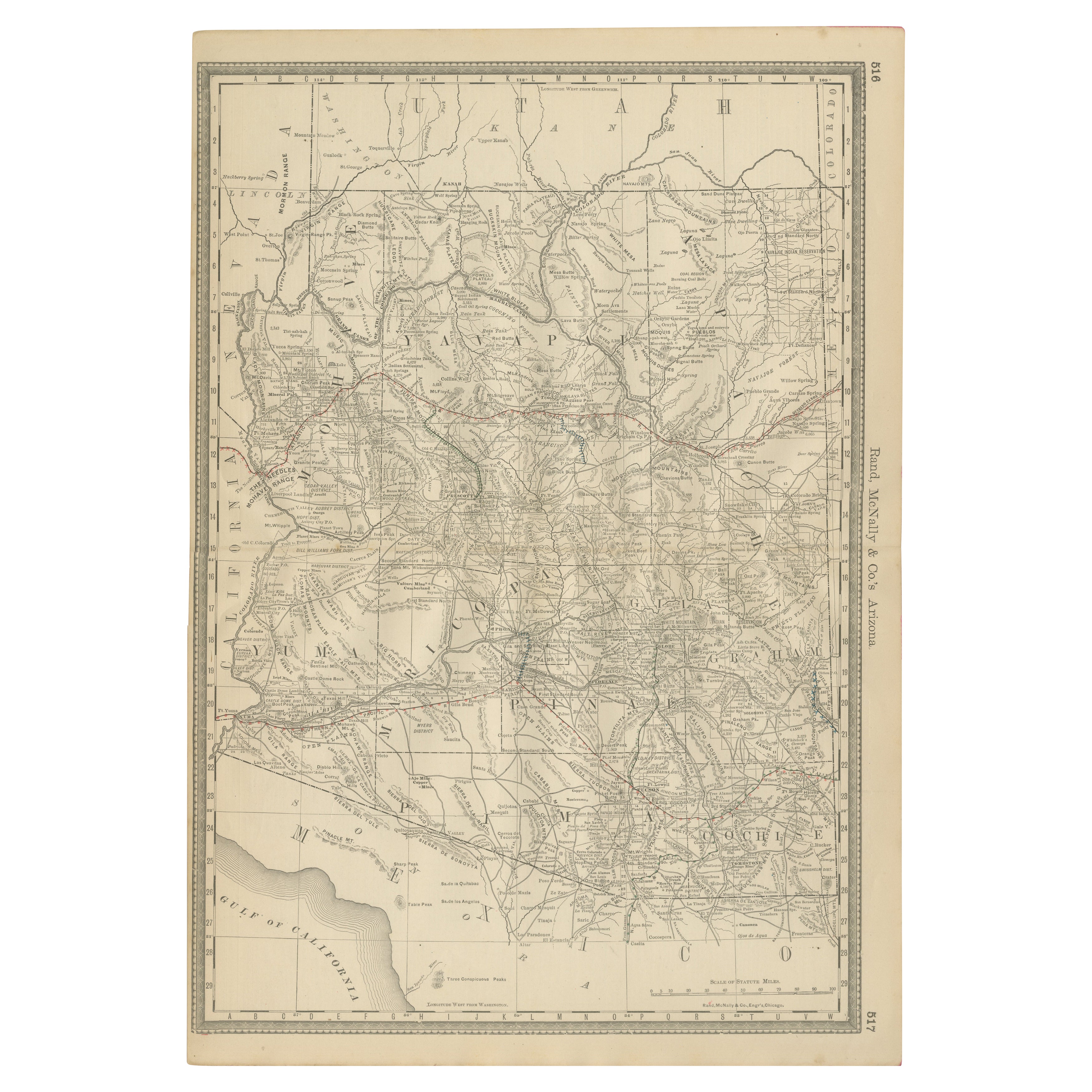
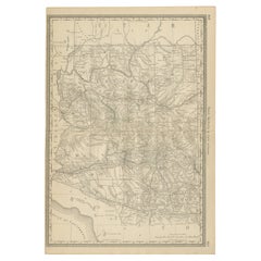
Rare 1888 Map of Arizona – Railroads, Mines & Early Frontier Settlements
Located in Langweer, NL
Antique Map of Arizona – Railroads, Mining Districts & Settlements, 1888
This antique engraved map presents the Territory of Arizona as it appeared in 1888, a period when the region...
Category
Antique Late 19th Century American Maps
Materials
Paper
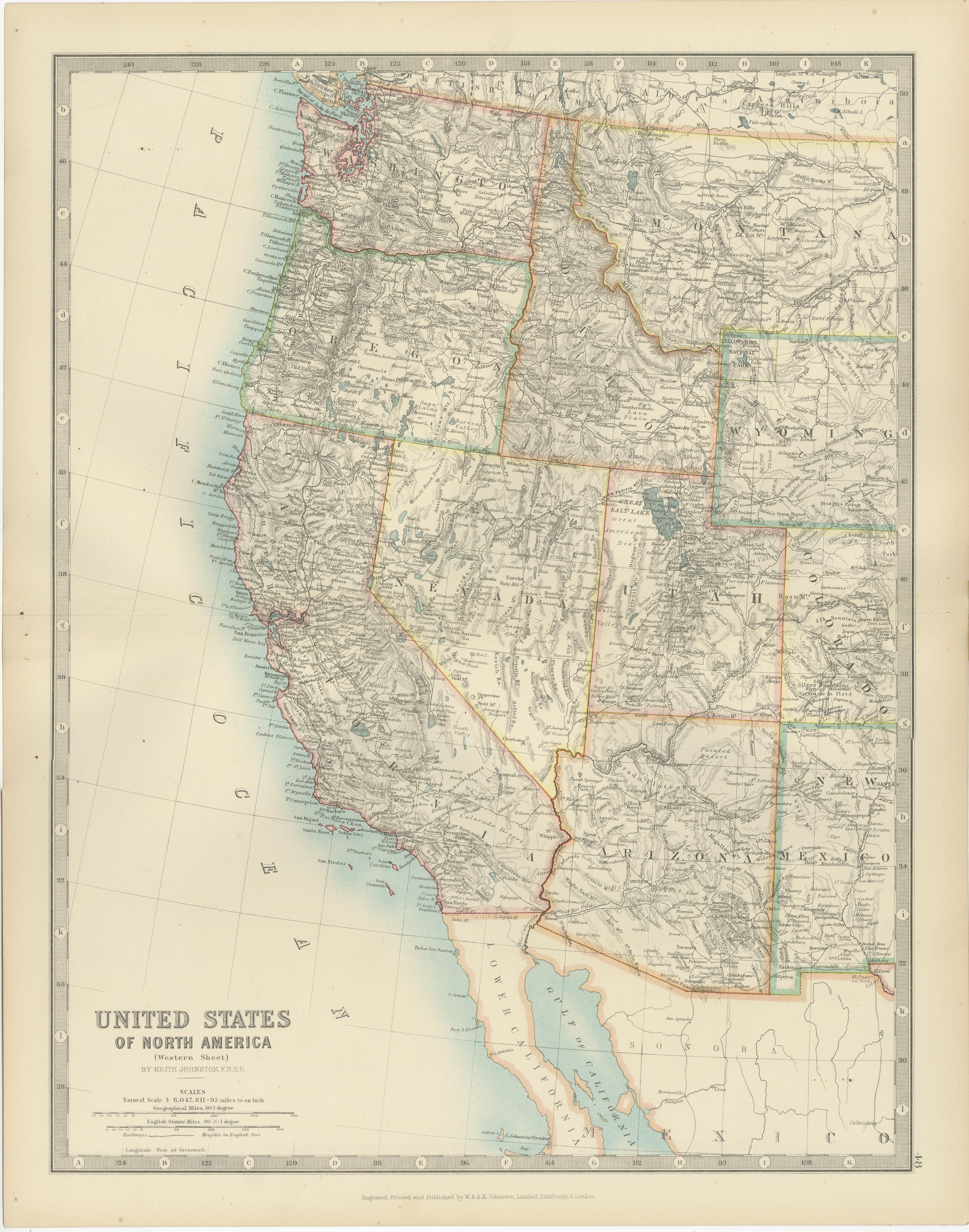
Map of Western United States 1903 – Railroads, State Borders, and Terrain
Located in Langweer, NL
Map of Western United States 1903 – Railroads, State Borders, and Terrain
This beautifully engraved map titled "United States of North America (Western Sheet)" was created by Keith ...
Category
Early 20th Century Maps
Materials
Paper

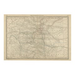
1888 Colorado Map – The Centennial State’s Railroads, Mines & Counties
Located in Langweer, NL
Antique Map of Colorado – Railroads, Mining Towns & Counties, 1888
This antique engraved map depicts the state of Colorado in 1888, published by Rand, McNally & Co. in Chicago for t...
Category
Antique Late 19th Century American Maps
Materials
Paper
1888 New Mexico Map – Railroads, Counties & The Land of Enchantment
Located in Langweer, NL
Antique Map of New Mexico – Railroads, Counties & Frontier Settlements, 1888
This antique engraved map depicts the Territory of New Mexico in 1888, engraved and published by Rand, M...
Category
Antique Late 19th Century American Maps
Materials
Paper

You May Also Like
Original Antique Map of the American State of Oregon, 1903
Located in St Annes, Lancashire
Antique map of Oregon
Published By A & C Black. 1903
Original colour
Good condition
Unframed.
Free shipping
Category
Antique Early 1900s English Maps
Materials
Paper

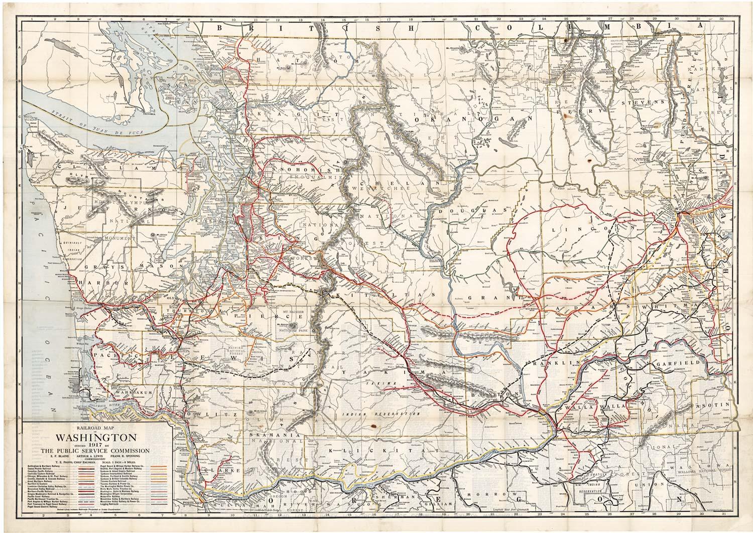
Original 1917 Railroad Map of Washington State railway map
Located in Spokane, WA
This is an Original Lithograph Vintage Railroad Map of Washington State; it is not a reproduction.
“Railroad Map of Washington, 1917, The Public Servi...
Category
1910s Academic Landscape Prints
Materials
Lithograph
$680 Sale Price
20% Off
Large Original Antique Map of Oregon, USA, 1894
By Rand McNally & Co.
Located in St Annes, Lancashire
Fabulous map of Oregon.
Original color.
By Rand, McNally & Co.
Published, 1894.
Unframed.
Free shipping.
Category
Antique 1890s American Maps
Materials
Paper
Original Antique Map of the American State of Oregon, 1889
Located in St Annes, Lancashire
Great map of Oregon
Drawn and Engraved by W. & A.K. Johnston
Published By A & C Black, Edinburgh.
Original colour
Unframed.
Category
Antique 1880s Scottish Victorian Maps
Materials
Paper
Original Antique Map of the American State of Washington, 1903
Located in St Annes, Lancashire
Antique map of Washington
Published By A & C Black. 1903
Original colour
Good condition
Unframed.
Free shipping
Category
Antique Early 1900s English Maps
Materials
Paper

Original Antique Map of the American State of Washington, 1889
Located in St Annes, Lancashire
Great map of Washington
Drawn and Engraved by W. & A.K. Johnston
Published By A & C Black, Edinburgh.
Original colour
Unframed.
Category
Antique 1880s Scottish Victorian Maps
Materials
Paper
