Items Similar to 1888 California Map – The Golden State’s Railroads, Cities & Counties

Want more images or videos?
Request additional images or videos from the seller
1 of 10
1888 California Map – The Golden State’s Railroads, Cities & Counties
$638.37
£476.33
€540
CA$888.21
A$993.93
CHF 517.05
MX$11,976.11
NOK 6,509.47
SEK 6,150.37
DKK 4,111.43
About the Item
Antique Map of California – Railroads, Cities & Counties, 1888
This antique engraved map shows California in 1888, at a time of enormous growth and transformation. Published by Rand, McNally & Co. in Chicago for their Improved Indexed Business Atlas and Shippers Guide, the map details the entire state with its expanding railroad network, counties, towns, and natural geography, just four decades after California became a U.S. state in 1850.
The railroads, carefully marked in red and blue, dominate the map. Major routes include the Southern Pacific system running north-south through the Central Valley, linking Sacramento, Fresno, and Los Angeles, and the transcontinental connection across the Sierra Nevada toward Nevada and the Union Pacific. The prominence of railroads reflects their crucial role in integrating California’s economy with the rest of the United States, enabling the export of agricultural produce, gold, silver, and later oil.
Key cities are clearly labeled, including San Francisco, Los Angeles, San Diego, Sacramento (the state capital), and Oakland, along with numerous smaller towns that were just beginning to grow, such as Riverside, Pasadena, and Santa Barbara. The map also shows mining towns of the Sierra Nevada foothills, remnants of the California Gold Rush that had reshaped the state’s history just a few decades earlier. County boundaries are distinctly drawn, including early administrative divisions such as San Bernardino, Kern, Sonoma, Monterey, and Humboldt.
Natural features such as the Sierra Nevada range, Yosemite Valley, Lake Tahoe, and the Pacific coastline are depicted in detail. Offshore, the Channel Islands appear, while the contours of San Francisco Bay are precisely engraved, highlighting its importance as a hub of shipping and trade.
The timing of this map makes it particularly valuable: by 1888, California was transitioning from its frontier and mining past into an agricultural and urban powerhouse. Los Angeles and Southern California were experiencing a land boom, fueled by railroads and real estate promotion, while San Francisco remained the dominant port of the Pacific Coast. This map reflects both the practical shipping routes of the time and the optimism of California’s future development.
Condition summary: Good condition with even toning and some light foxing at the margins. Original fold lines as issued, paper strong with a clear plate impression. No major tears or repairs.
Framing tips: A dark oak or walnut frame will emphasize the antique quality of this map, while a black frame with ivory or parchment mount will create a crisp modern display. A double mat, perhaps ivory with a golden-brown accent, can highlight California’s warm tones and historic character.
Technique: Engraving
Maker: Rand, McNally & Co., Chicago, 1888
- Dimensions:Height: 20.67 in (52.5 cm)Width: 14.18 in (36 cm)Depth: 0.01 in (0.2 mm)
- Materials and Techniques:Paper,Engraved
- Place of Origin:
- Period:
- Date of Manufacture:1888
- Condition:Condition summary: Good condition with even toning and some light foxing at the margins. Original fold lines as issued, paper strong with a clear plate impression. No major tears or repairs.
- Seller Location:Langweer, NL
- Reference Number:Seller: BG-12794-601stDibs: LU3054346342542
About the Seller
5.0
Recognized Seller
These prestigious sellers are industry leaders and represent the highest echelon for item quality and design.
Platinum Seller
Premium sellers with a 4.7+ rating and 24-hour response times
Established in 2009
1stDibs seller since 2017
2,587 sales on 1stDibs
Typical response time: <1 hour
- ShippingRetrieving quote...Shipping from: Langweer, Netherlands
- Return Policy
Authenticity Guarantee
In the unlikely event there’s an issue with an item’s authenticity, contact us within 1 year for a full refund. DetailsMoney-Back Guarantee
If your item is not as described, is damaged in transit, or does not arrive, contact us within 7 days for a full refund. Details24-Hour Cancellation
You have a 24-hour grace period in which to reconsider your purchase, with no questions asked.Vetted Professional Sellers
Our world-class sellers must adhere to strict standards for service and quality, maintaining the integrity of our listings.Price-Match Guarantee
If you find that a seller listed the same item for a lower price elsewhere, we’ll match it.Trusted Global Delivery
Our best-in-class carrier network provides specialized shipping options worldwide, including custom delivery.More From This Seller
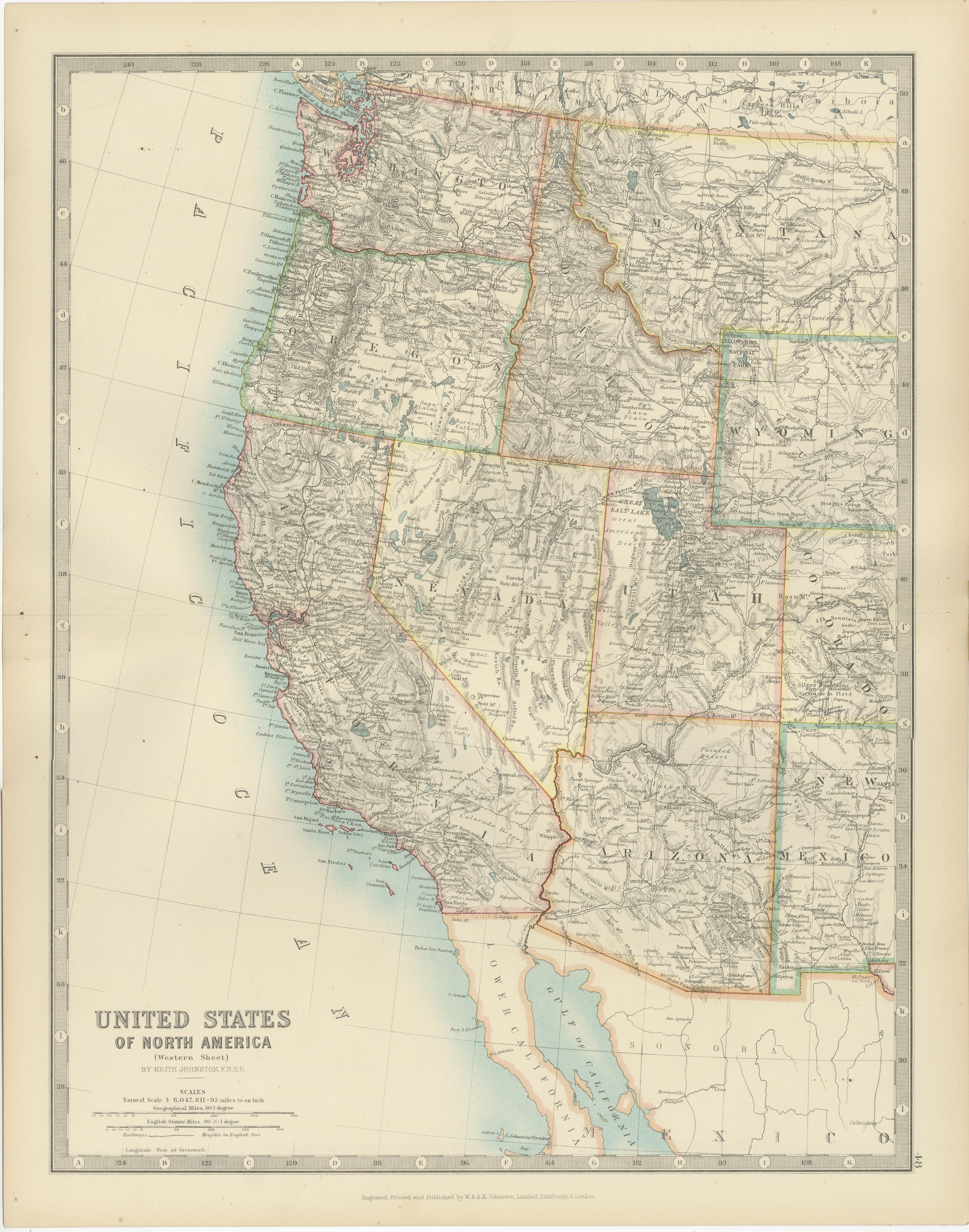
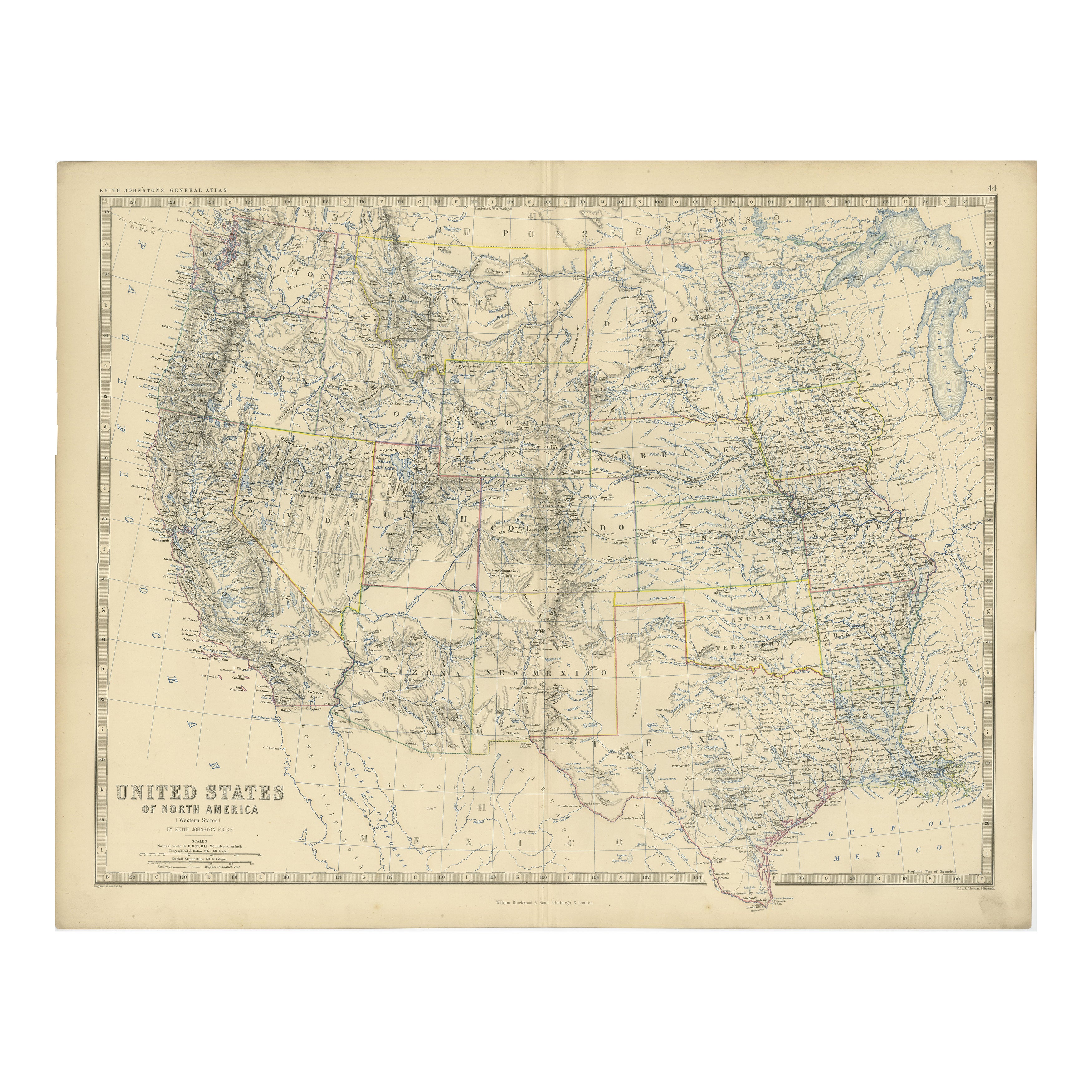
View AllMap of Western United States 1903 – Railroads, State Borders, and Terrain
Located in Langweer, NL
Map of Western United States 1903 – Railroads, State Borders, and Terrain
This beautifully engraved map titled "United States of North America (Western Sheet)" was created by Keith ...
Category
Early 20th Century Maps
Materials
Paper

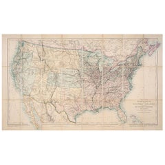
1874 Map of Western United States – Detailed Atlas by Keith Johnston
Located in Langweer, NL
1874 Map of Western United States by Keith Johnston – Detailed Atlas
This is an original antique map titled “United States of North America (Western States)” by Alexander Keith John...
Category
Antique 1870s Scottish Maps
Materials
Paper

Antique Map of Part of the United States Including Lower California & Arizona
Located in Langweer, NL
Antique map of part of the United States of America including Lower California, Arizona and part of Mexico. This map was part of a set of six individual sheets with maps of the Unite...
Category
Antique Late 19th Century Maps
Materials
Paper

$416 Sale Price
20% Off
Antique Map of The United States of North America, Pacific States, 1882
Located in Langweer, NL
The map is from the same 1882 Blackie Atlas and focuses on the Pacific States of the United States of America during that period. Here are some details and historical context about t...
Category
Antique 1880s Maps
Materials
Paper

$236 Sale Price
20% Off
Free Shipping
Antique Map of California, Utah, Nevada, Colorado, New Mexico & Arizona '1872'
Located in Langweer, NL
Antique map titled 'Johnson's California (..)'. Original map of California, Utah, Nevada, Colorado, New Mexico and Arizona. This map originates from ...
Category
Antique Late 19th Century Maps
Materials
Paper

$236 Sale Price
20% Off
1876 Map of the United States: Detailing the Railroads and Unsettled Territories
Located in Langweer, NL
Stanford’s Smaller Railway Map of the United States, 1876
This original 1876 map, titled "Stanford's Smaller Railway Map of the United States Distinguishing the Unsettled Territorie...
Category
Antique 1870s Maps
Materials
Paper
You May Also Like
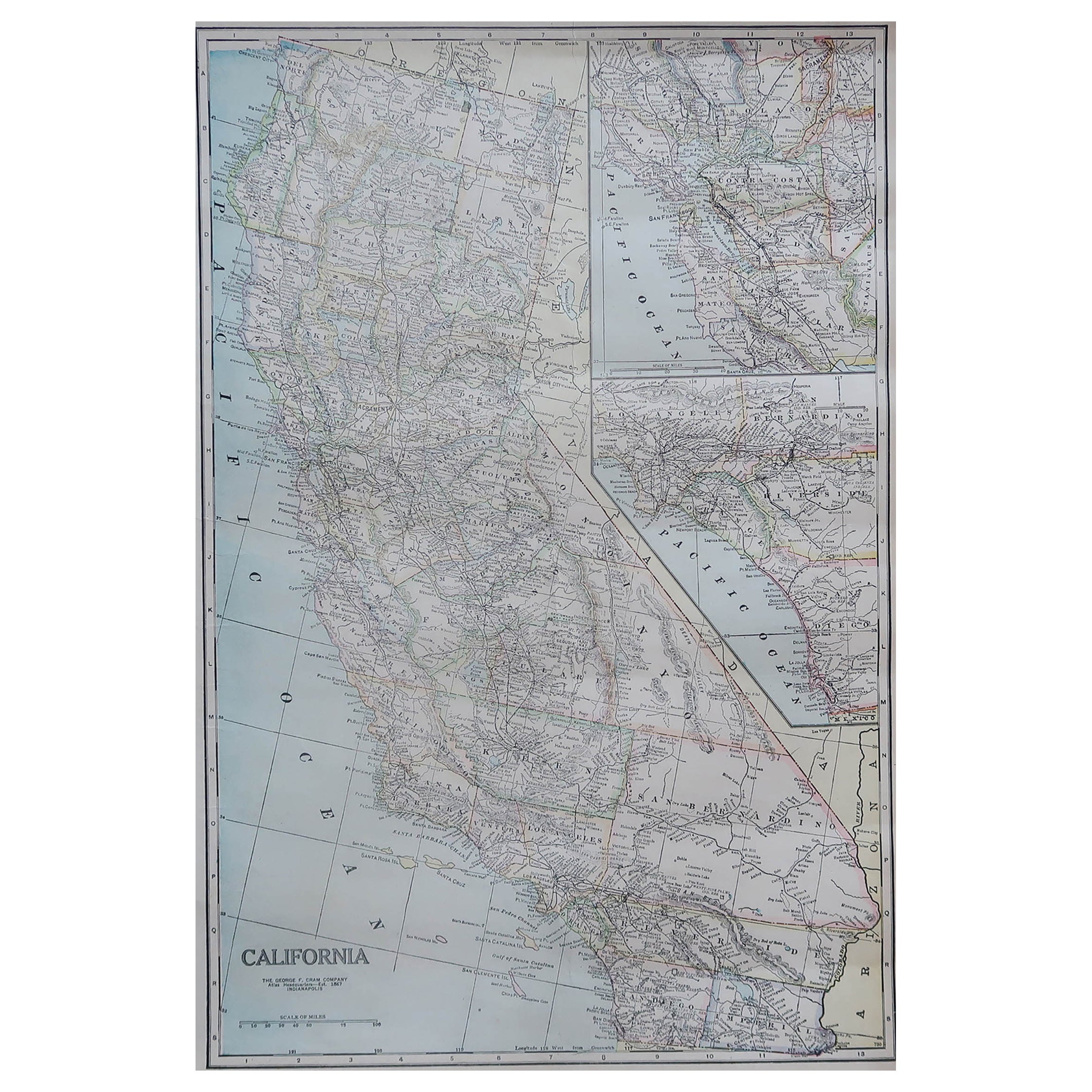
Large Original Antique Map of California, USA, circa 1900
Located in St Annes, Lancashire
Fabulous map of California
Original color
Engraved and printed by the George F. Cram Company, Indianapolis.
Published, circa 1900
Unframed
Free shipping.
Category
Antique 1890s American Maps
Materials
Paper

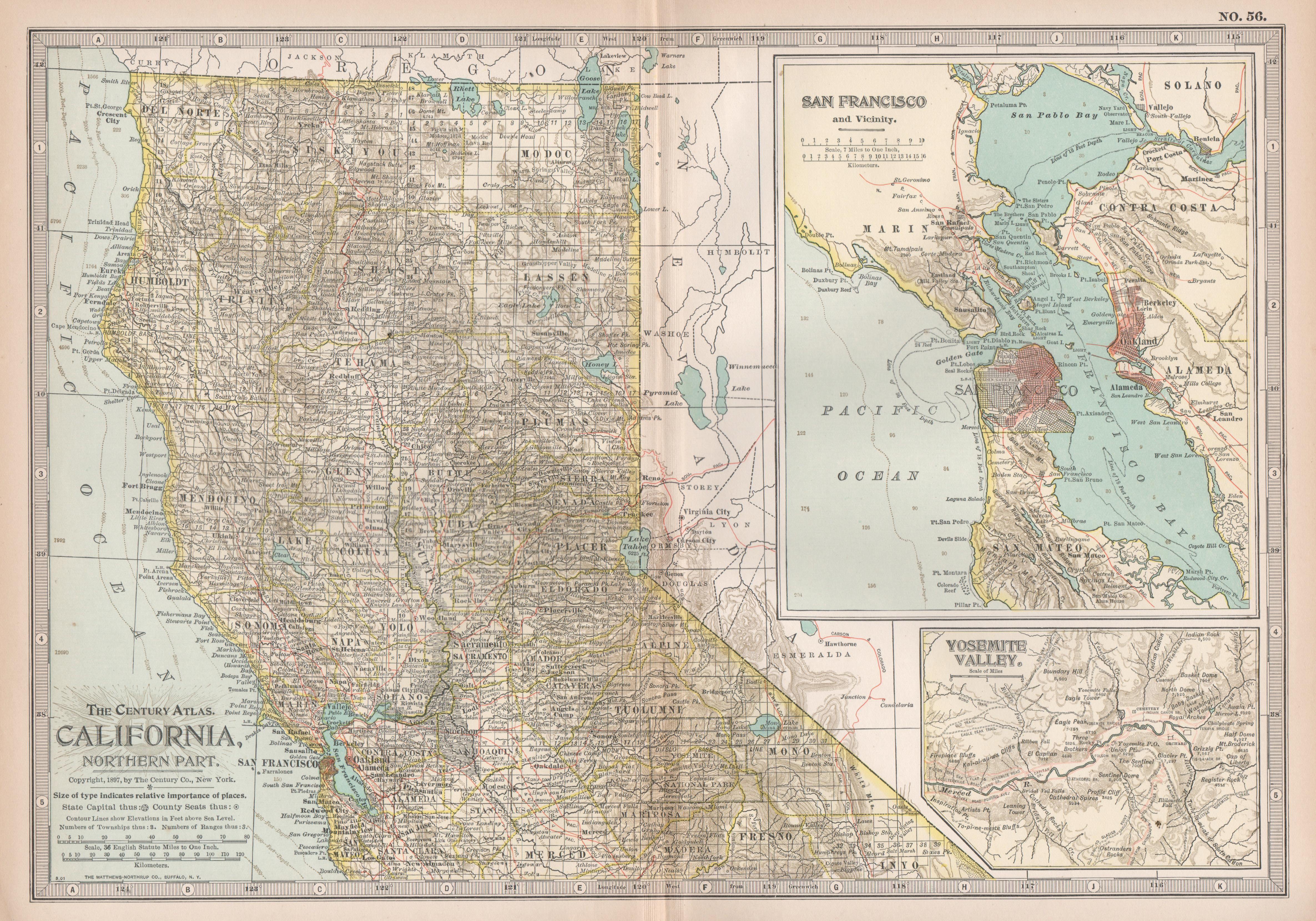
Original Antique Map of the American State of California ( Northern Part ), 1903
Located in St Annes, Lancashire
Antique map of California ( Northern part )
Published By A & C Black. 1903
Original colour
Good condition
Unframed.
Free shipping
Category
Antique Early 1900s English Maps
Materials
Paper

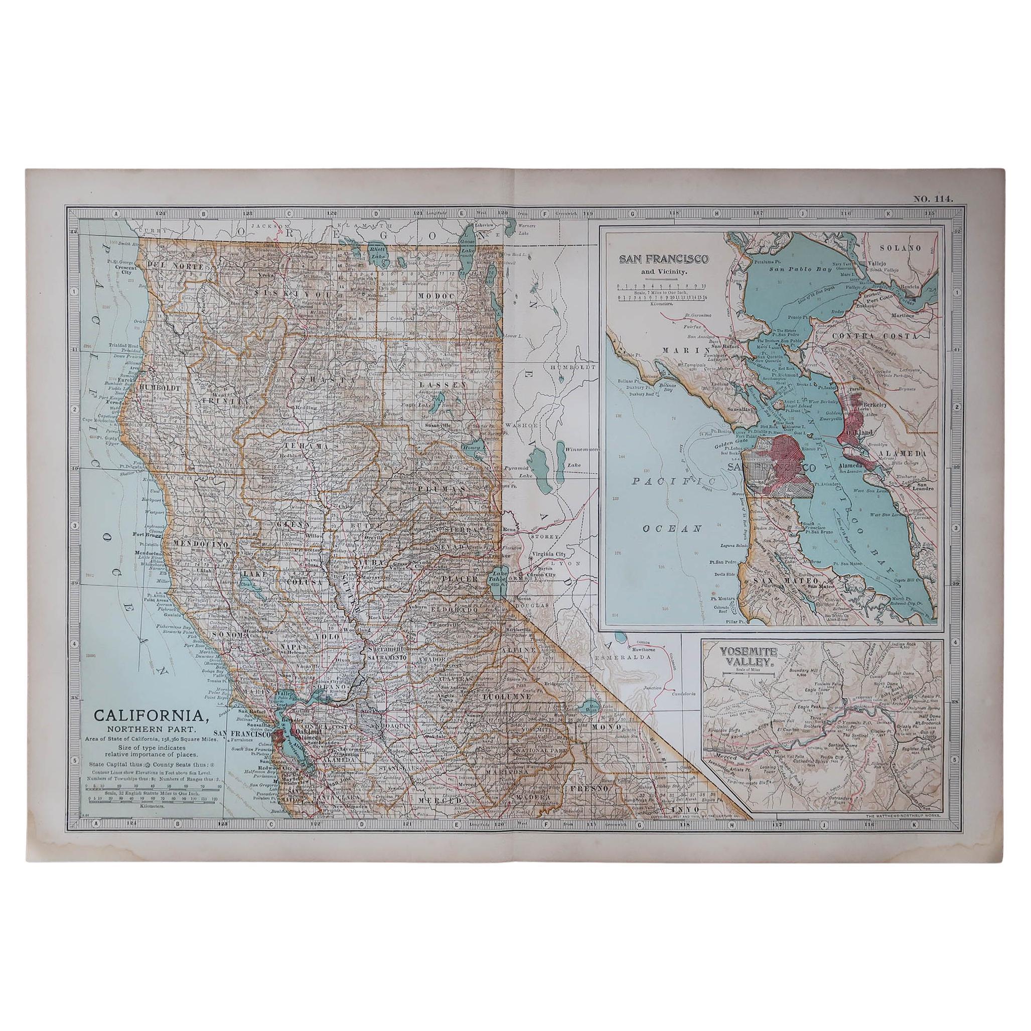
California, Northern Part. USA Century Atlas state antique vintage map
Located in Melbourne, Victoria
'The Century Atlas. California, Northern Part'
Inset maps of 'Yosemite Valley' and 'San Francisco and Vicinity'.
Original antique map, 1903.
Central fold as issued. Map name and nu...
Category
Early 20th Century Victorian More Prints
Materials
Lithograph
Original Antique Map of the American State of California ( Southern Part ), 1903
Located in St Annes, Lancashire
Antique map of California ( Southern part )
Published By A & C Black. 1903
Original colour
Good condition
Unframed.
Free shipping
Category
Antique Early 1900s English Maps
Materials
Paper

Original Antique Map of the American State of Nevada, 1889
Located in St Annes, Lancashire
Great map of Nevada
Drawn and Engraved by W. & A.K. Johnston
Published By A & C Black, Edinburgh.
Original colour
Unframed.
Category
Antique 1880s Scottish Victorian Maps
Materials
Paper
1873 "Map of the States of California and Nevada" by Chas. Drayton Gibbes
Located in Colorado Springs, CO
Presented is Warren Holt and Charles Drayton Gibbes' 1873 “Map of California and Nevada.” This map is considered to be one of the finest large-scale ...
Category
Antique 1870s American Maps
Materials
Paper
