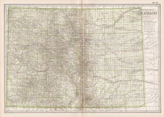
Items Similar to 1888 Colorado Map – The Centennial State’s Railroads, Mines & Counties


Want more images or videos?
Request additional images or videos from the seller
1 of 12
1888 Colorado Map – The Centennial State’s Railroads, Mines & Counties
$567.44
£423.41
€480
CA$789.52
A$883.49
CHF 459.60
MX$10,645.43
NOK 5,786.20
SEK 5,466.99
DKK 3,654.60
About the Item
Antique Map of Colorado – Railroads, Mining Towns & Counties, 1888
This antique engraved map depicts the state of Colorado in 1888, published by Rand, McNally & Co. in Chicago for their Improved Indexed Business Atlas and Shippers Guide. It captures Colorado during a formative period, just over a decade after achieving statehood in 1876, when railroads and mining shaped its growth and identity.
The map highlights Colorado’s extensive railroad system, engraved in red and blue, reflecting the central role of rail transport in the state’s economy. Lines radiate outward from Denver, already established as the state capital and commercial hub, linking to major cities such as Pueblo, Colorado Springs, and Leadville, as well as smaller mining towns in the Rocky Mountains. The Denver & Rio Grande, Atchison, Topeka & Santa Fe, and Union Pacific systems are all represented, demonstrating the state’s integration into national transport and trade networks.
Counties are clearly defined, including Arapahoe, Jefferson, El Paso, Weld, Boulder, Fremont, and Gunnison, alongside the rugged mountain counties such as Lake, Pitkin, San Juan, and San Miguel, where mining booms brought waves of settlement. Mining towns such as Leadville, Silverton, Ouray, and Aspen are labeled, places which became legendary for their silver and gold production during the Colorado Silver Boom of the 1880s. Agricultural and ranching regions on the eastern plains are also shown, contrasting with the mountainous west.
The geography of Colorado is depicted with remarkable clarity, showing the Continental Divide, the Front Range, and river systems such as the Arkansas, Platte, and Rio Grande. These natural features not only shaped settlement patterns but also defined the challenges of building railroads through some of the most difficult terrain in North America.
The historical context makes this map particularly significant. In 1888, Colorado was experiencing rapid growth fueled by mining wealth, railroad expansion, and migration. Denver was becoming a major metropolitan center, while the mountain towns were at the height of their mining prosperity. This map provides a snapshot of that era, when Colorado balanced frontier ruggedness with economic ambition.
Condition summary: Very good condition overall, with mild toning consistent with age. Some faint foxing and handling marks in the margins. Original fold line as issued, paper strong with clear engraved detail. No significant tears or repairs.
Framing tips: A walnut or dark oak frame will highlight the antique qualities of the piece, while a black frame with ivory matting provides a sharp modern presentation. A double mat, ivory with a muted silver or grey accent, can emphasize Colorado’s mining heritage and mountainous terrain.
Technique: Engraving
Maker: Rand, McNally & Co., Chicago, 1888
- Dimensions:Height: 14.18 in (36 cm)Width: 20.67 in (52.5 cm)Depth: 0.01 in (0.2 mm)
- Materials and Techniques:Paper,Engraved
- Place of Origin:
- Period:
- Date of Manufacture:1888
- Condition:Condition summary: Very good condition overall, with mild toning consistent with age. Some faint foxing and handling marks in the margins. Original fold line as issued, paper strong with clear engraved detail. No significant tears or repairs.
- Seller Location:Langweer, NL
- Reference Number:Seller: BG-12794-551stDibs: LU3054346346822
About the Seller
5.0
Recognized Seller
These prestigious sellers are industry leaders and represent the highest echelon for item quality and design.
Platinum Seller
Premium sellers with a 4.7+ rating and 24-hour response times
Established in 2009
1stDibs seller since 2017
2,587 sales on 1stDibs
Typical response time: <1 hour
- ShippingRetrieving quote...Shipping from: Langweer, Netherlands
- Return Policy
Authenticity Guarantee
In the unlikely event there’s an issue with an item’s authenticity, contact us within 1 year for a full refund. DetailsMoney-Back Guarantee
If your item is not as described, is damaged in transit, or does not arrive, contact us within 7 days for a full refund. Details24-Hour Cancellation
You have a 24-hour grace period in which to reconsider your purchase, with no questions asked.Vetted Professional Sellers
Our world-class sellers must adhere to strict standards for service and quality, maintaining the integrity of our listings.Price-Match Guarantee
If you find that a seller listed the same item for a lower price elsewhere, we’ll match it.Trusted Global Delivery
Our best-in-class carrier network provides specialized shipping options worldwide, including custom delivery.More From This Seller
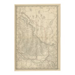
View All1888 Idaho Map – The Gem State’s Railroads, Mining Camps & Counties
Located in Langweer, NL
Antique Map of Idaho – Railroads, Mining Camps & Counties, 1888
This antique engraved map depicts the Territory of Idaho in 1888, engraved and published by Rand, McNally & Co. in Ch...
Category
Antique Late 19th Century American Maps
Materials
Paper
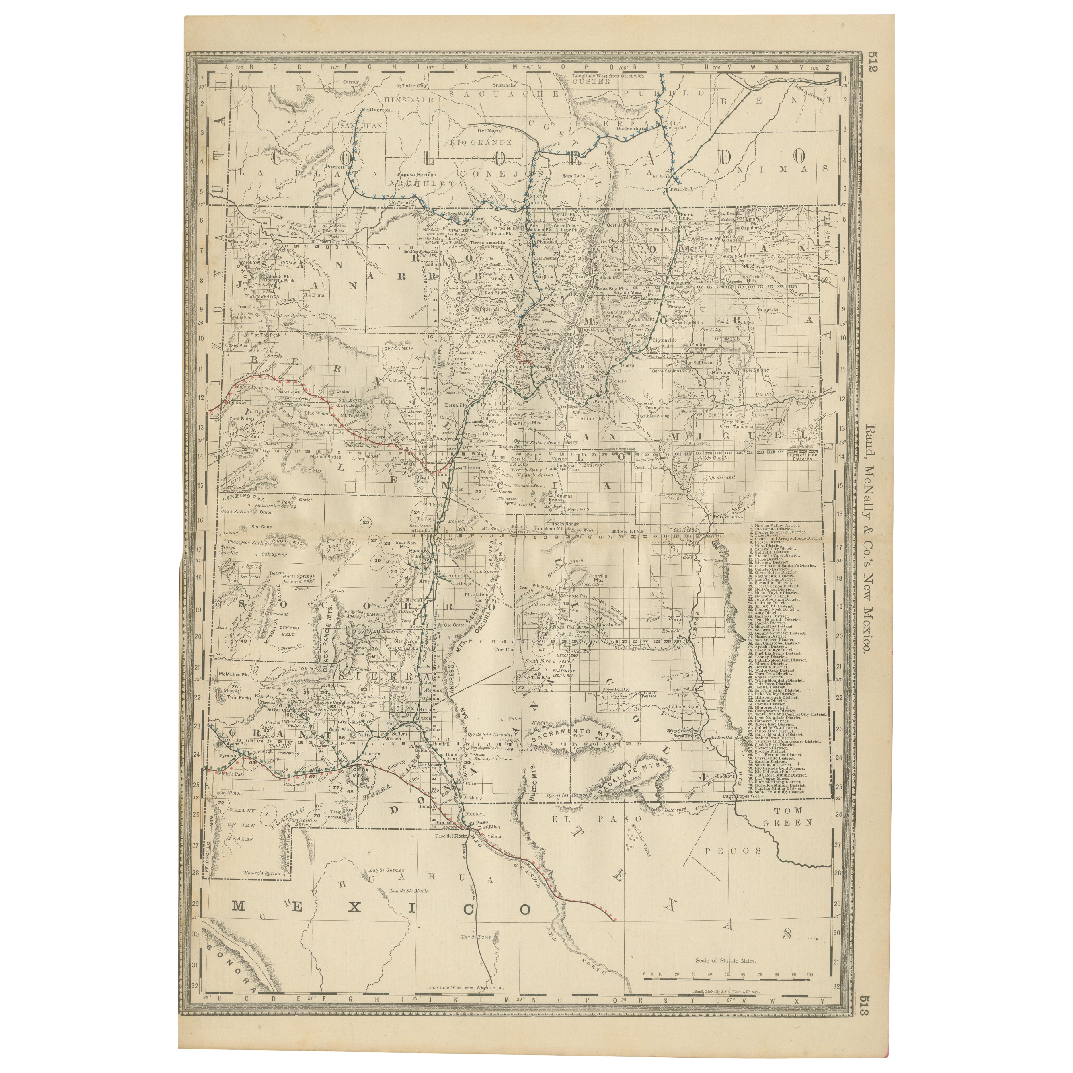
1888 New Mexico Map – Railroads, Counties & The Land of Enchantment
Located in Langweer, NL
Antique Map of New Mexico – Railroads, Counties & Frontier Settlements, 1888
This antique engraved map depicts the Territory of New Mexico in 1888, engraved and published by Rand, M...
Category
Antique Late 19th Century American Maps
Materials
Paper

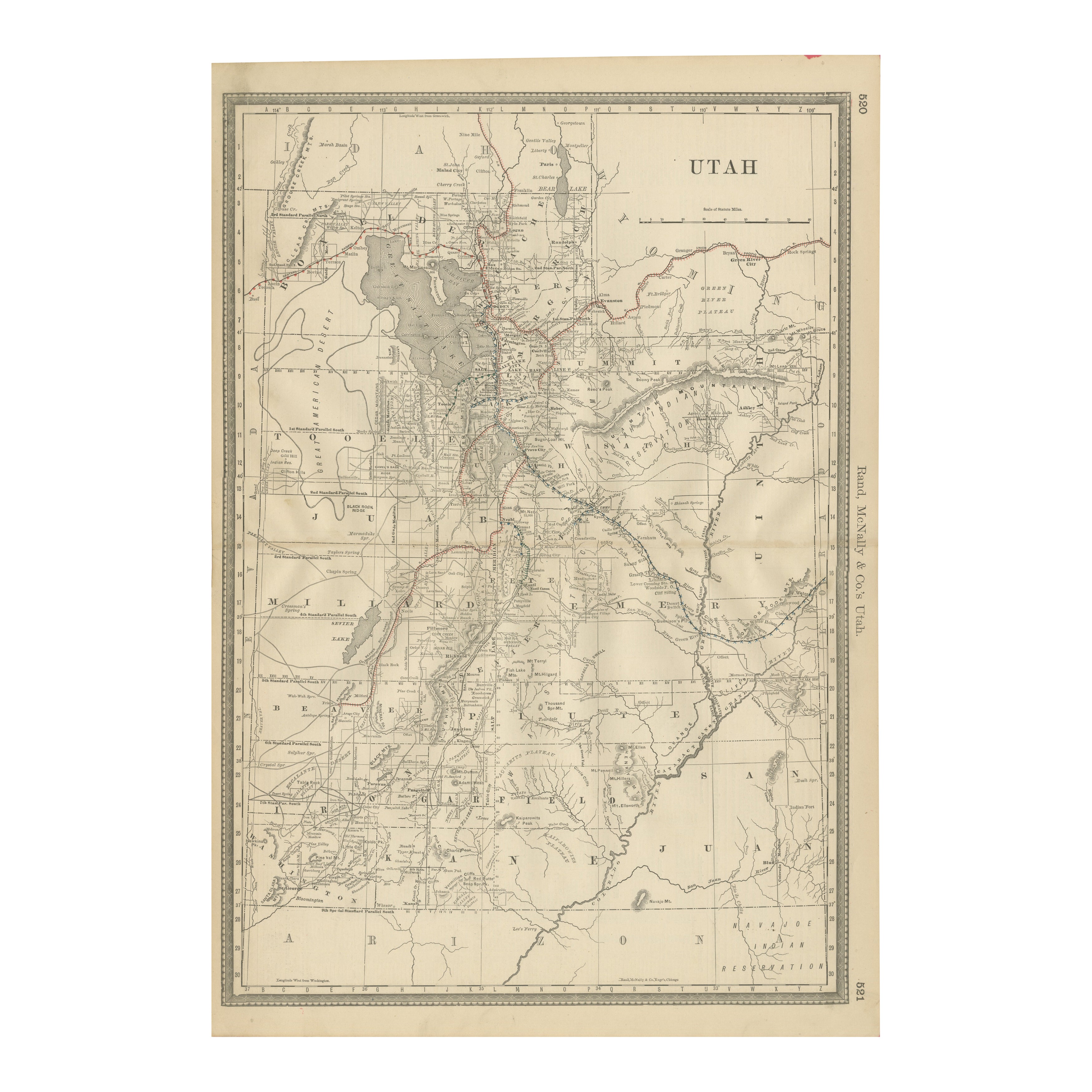
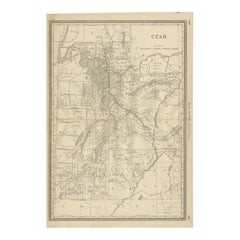
Rare 1888 Utah Map – The Beehive State’s Railroads, Counties & Great Salt Lake
Located in Langweer, NL
Antique Map of Utah – Railroads, Counties & Great Salt Lake, 1888
This antique engraved map presents the Territory of Utah in 1888, published by Rand, McNally & Co. in Chicago for t...
Category
Antique Late 19th Century American Maps
Materials
Paper
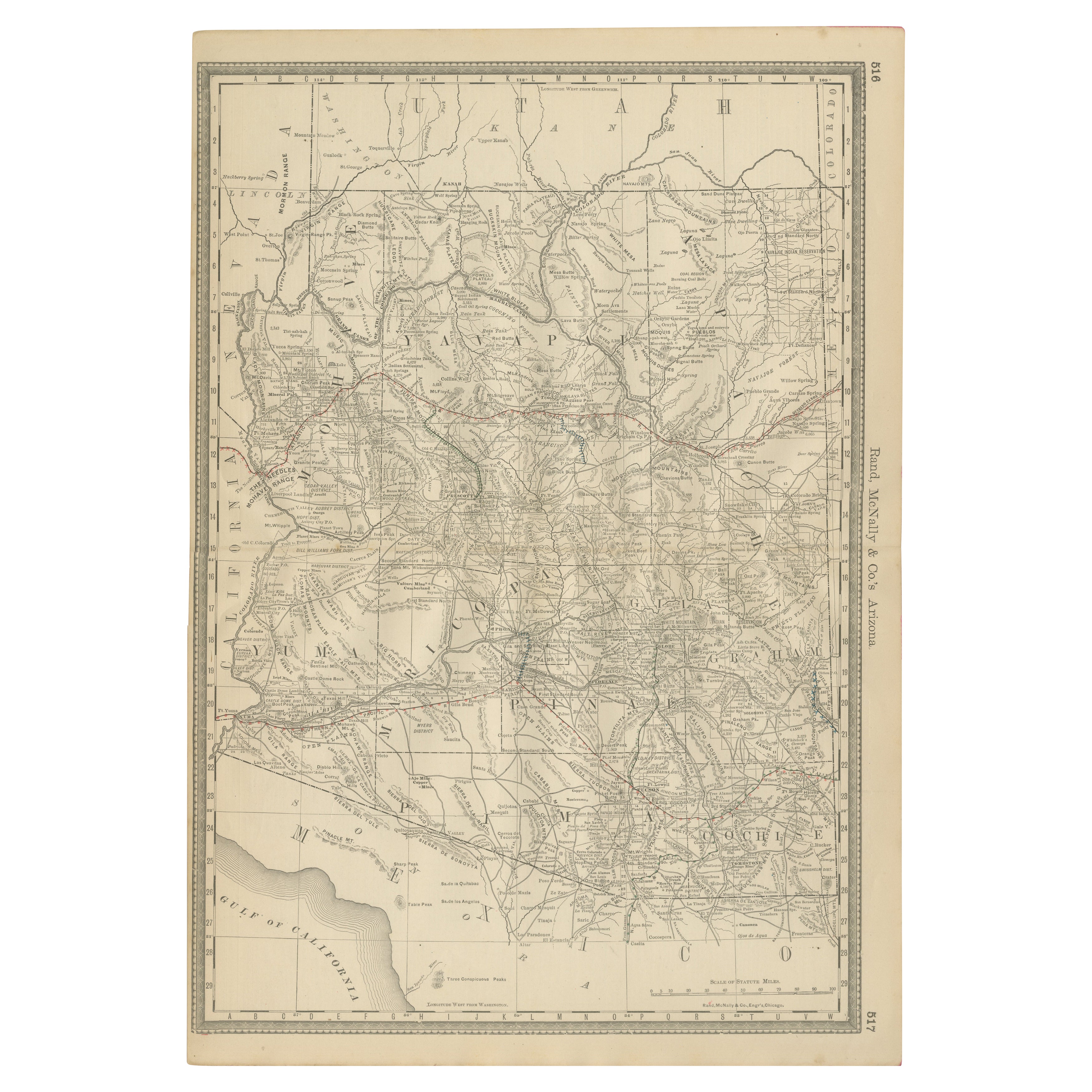
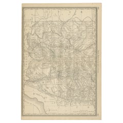
Rare 1888 Map of Arizona – Railroads, Mines & Early Frontier Settlements
Located in Langweer, NL
Antique Map of Arizona – Railroads, Mining Districts & Settlements, 1888
This antique engraved map presents the Territory of Arizona as it appeared in 1888, a period when the region...
Category
Antique Late 19th Century American Maps
Materials
Paper
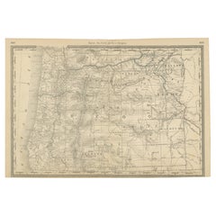
1888 Antique Map of Oregon – Railroads, Counties & Native Indian Reservations
Located in Langweer, NL
Antique Map of Oregon – Railroads, Indian Reservations & Counties, 1888
This antique engraved map presents the state of Oregon in 1888, a time when the Pacific Northwest was rapidly...
Category
Antique Late 19th Century American Maps
Materials
Paper
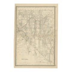
Antique Map of Nevada – Railroads, Mining Camps & Counties, 1888
Located in Langweer, NL
Antique Map of Nevada – Railroads, Mining Camps & Counties, 1888
This antique engraved map depicts the state of Nevada in 1888, engraved and published by Rand, McNally & Co. in Chic...
Category
Antique Late 19th Century American Maps
Materials
Paper
You May Also Like
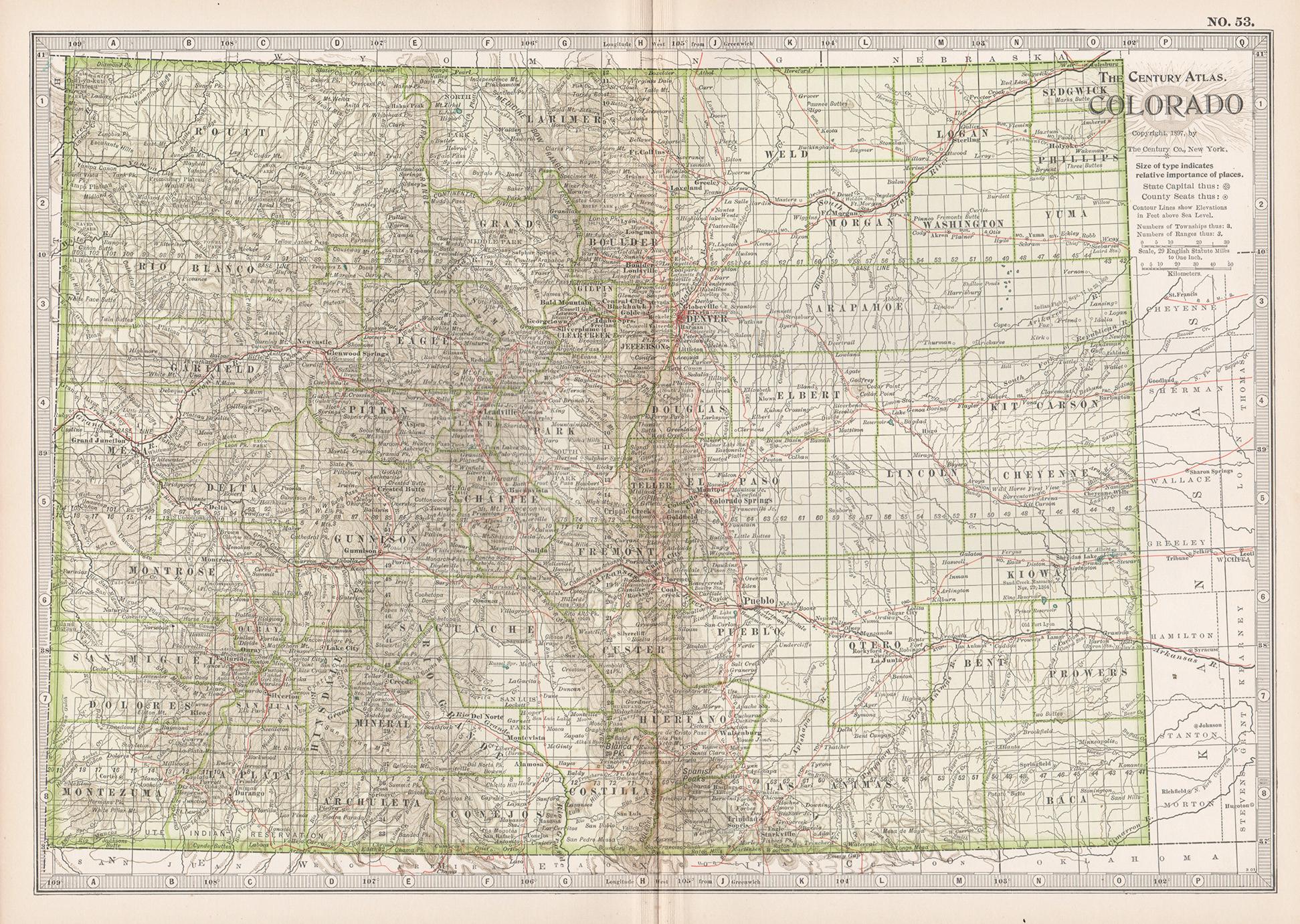
Colorado. USA. Century Atlas state antique vintage map
Located in Melbourne, Victoria
'The Century Atlas. Colorado.'
Original antique map, 1903.
Central fold as issued. Map name and number printed on the reverse corners.
Sheet 29.5cm by 40cm.
Category
Early 20th Century Victorian More Prints
Materials
Lithograph
Original Antique Map of the American State of Colorado, 1903
Located in St Annes, Lancashire
Antique map of Colorado
Published By A & C Black. 1903
Original colour
Good condition
Unframed.
Free shipping
Category
Antique Early 1900s English Maps
Materials
Paper

1904 "Nell's Topographical Map of the State of Colorado"
Located in Colorado Springs, CO
This highly detailed pocket map is a topographical map of the state of Colorado by Louis Nell from 1904. The map "has been compiled from all available...
Category
Antique Early 1900s American Maps
Materials
Leather, Paper

Large Original Antique Map of Utah, USA, 1894
By Rand McNally & Co.
Located in St Annes, Lancashire
Fabulous map of Utah
Original color
By Rand, McNally & Co.
Published, 1894
Unframed
Free shipping.
Category
Antique 1890s American Maps
Materials
Paper

Montana. USA. Century Atlas state antique vintage map
Located in Melbourne, Victoria
'The Century Atlas. Montana'
Original antique map, 1903.
Central fold as issued. Map name and number printed on the reverse corners.
Sheet 29.5cm by 40cm.
Category
Early 20th Century Victorian More Prints
Materials
Lithograph
Original Antique Map of the American State of Idaho & Wyoming, 1903
Located in St Annes, Lancashire
Antique map of Idaho and Wyoming
Published By A & C Black. 1903
Original colour
Good condition
Unframed.
Free shipping
Category
Antique Early 1900s English Maps
Materials
Paper
