Items Similar to Alabama Antique Map 1888 – The Heart of Dixie, Railroads & Towns
Want more images or videos?
Request additional images or videos from the seller
1 of 10
Alabama Antique Map 1888 – The Heart of Dixie, Railroads & Towns
$550
£406.71
€460
CA$761.11
A$847.45
CHF 441
MX$10,228.58
NOK 5,530.51
SEK 5,223.92
DKK 3,502.92
About the Item
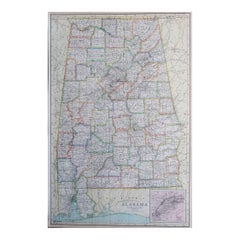
Alabama Map 1888 – Rand McNally Antique Lithograph
This antique 1888 map of Alabama, published by Rand, McNally & Co., provides a highly detailed view of the state during a period of industrial expansion and agricultural reliance. The map shows counties, towns, railroads, and rivers, illustrating Alabama at a time when railroads were reshaping its economy and connecting the state to broader national trade networks.
Counties are neatly engraved with county seats marked, from the fertile Black Belt counties of Dallas, Perry, and Marengo to the northern regions around Madison, Limestone, and Lauderdale. Major cities such as Montgomery, Birmingham, Mobile, and Huntsville are prominently shown, along with countless smaller towns and settlements that had developed along railway lines and rivers.
Railroads, printed in red and blue, dominate the map, highlighting the state’s growing transportation infrastructure. Lines such as the Louisville & Nashville Railroad, the Alabama Great Southern, and the East Tennessee, Virginia & Georgia Railroad are all represented. These connections underscored Birmingham’s rapid rise as an industrial center based on coal, iron, and steel, while Mobile continued to function as a vital Gulf Coast port for cotton and lumber exports.
The state’s natural features are also carefully marked, with rivers including the Alabama, Tombigbee, and Tennessee playing central roles in both transportation and agriculture. The Gulf of Mexico coastline with Mobile Bay is clearly delineated, showing the port city’s crucial place in international trade.
This map is an excellent example of Rand, McNally’s cartographic precision, designed both for practical reference and as a historical record. It illustrates Alabama in the post-Reconstruction era, as it transitioned into a more industrialized economy while still deeply tied to agriculture.
For collectors, genealogists, and historians of the American South, this 1888 Alabama map offers a valuable snapshot of the state’s infrastructure and settlement during an important moment of transformation.
Condition: Very good, with light age toning and mild foxing, mostly in margins. Center fold as issued. Paper strong with plate mark visible; no tears or major damage.
Framing tips: A dark wood or black frame with a cream mat will highlight the density of the railroad network. For added emphasis, a secondary mat in red can draw attention to the railway routes.
Technique: Lithograph with printed detail
Maker: Rand, McNally & Co., Chicago, 1888
Special note: Maps of Southern states like Alabama from the late 19th century are especially appealing to collectors, as they capture both the agricultural Black Belt and the emergence of new industrial centers such as Birmingham. They also highlight the role of railroads in reshaping the post-Reconstruction South.
- Dimensions:Height: 20.67 in (52.5 cm)Width: 14.18 in (36 cm)Depth: 0.01 in (0.2 mm)
- Materials and Techniques:Paper,Engraved
- Place of Origin:
- Period:
- Date of Manufacture:1888
- Condition:Condition: Very good, with light age toning and mild foxing, mostly in margins. Center fold as issued. Paper strong with plate mark visible; no tears or major damage.
- Seller Location:Langweer, NL
- Reference Number:Seller: BG-12794-431stDibs: LU3054346391332
About the Seller
5.0
Recognized Seller
These prestigious sellers are industry leaders and represent the highest echelon for item quality and design.
Platinum Seller
Premium sellers with a 4.7+ rating and 24-hour response times
Established in 2009
1stDibs seller since 2017
2,588 sales on 1stDibs
Typical response time: <1 hour
- ShippingRetrieving quote...Shipping from: Langweer, Netherlands
- Return Policy
Authenticity Guarantee
In the unlikely event there’s an issue with an item’s authenticity, contact us within 1 year for a full refund. DetailsMoney-Back Guarantee
If your item is not as described, is damaged in transit, or does not arrive, contact us within 7 days for a full refund. Details24-Hour Cancellation
You have a 24-hour grace period in which to reconsider your purchase, with no questions asked.Vetted Professional Sellers
Our world-class sellers must adhere to strict standards for service and quality, maintaining the integrity of our listings.Price-Match Guarantee
If you find that a seller listed the same item for a lower price elsewhere, we’ll match it.Trusted Global Delivery
Our best-in-class carrier network provides specialized shipping options worldwide, including custom delivery.More From This Seller
View AllWestern Texas Antique Map 1888 – Railroads, Counties & Frontier Towns
Located in Langweer, NL
Western Texas Map 1888 – Rand McNally Antique Lithograph
This antique 1888 map of Western Texas, published by Rand, McNally & Co., depicts the vast frontier counties of the region a...
Category
Antique Late 19th Century American Maps
Materials
Paper
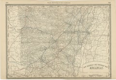
Antique Map of Arkansas 1888 – The Natural State, Railroads & Cities
Located in Langweer, NL
Arkansas Map 1888 – Rand McNally Antique Lithograph
This antique 1888 map of Arkansas, published by Rand, McNally & Co., provides a detailed portrayal of the state during the late 1...
Category
Antique Late 19th Century American Maps
Materials
Paper
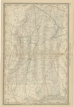
Mississippi Antique Map 1888 – The Magnolia State, Railroads & Counties
Located in Langweer, NL
Mississippi Map 1888 – Rand McNally Antique Lithograph
This antique 1888 map of Mississippi, published by Rand, McNally & Co., provides a highly detailed representation of the state...
Category
Antique Late 19th Century American Maps
Materials
Paper
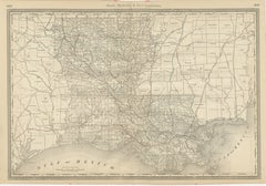
Louisiana Antique Map 1888 – The Pelican State, Railroads & Counties
Located in Langweer, NL
Louisiana Map 1888 – Rand McNally Antique Lithograph
This antique 1888 map of Louisiana, published by Rand, McNally & Co., provides a richly detailed picture of the state in the lat...
Category
Antique Late 19th Century American Maps
Materials
Paper
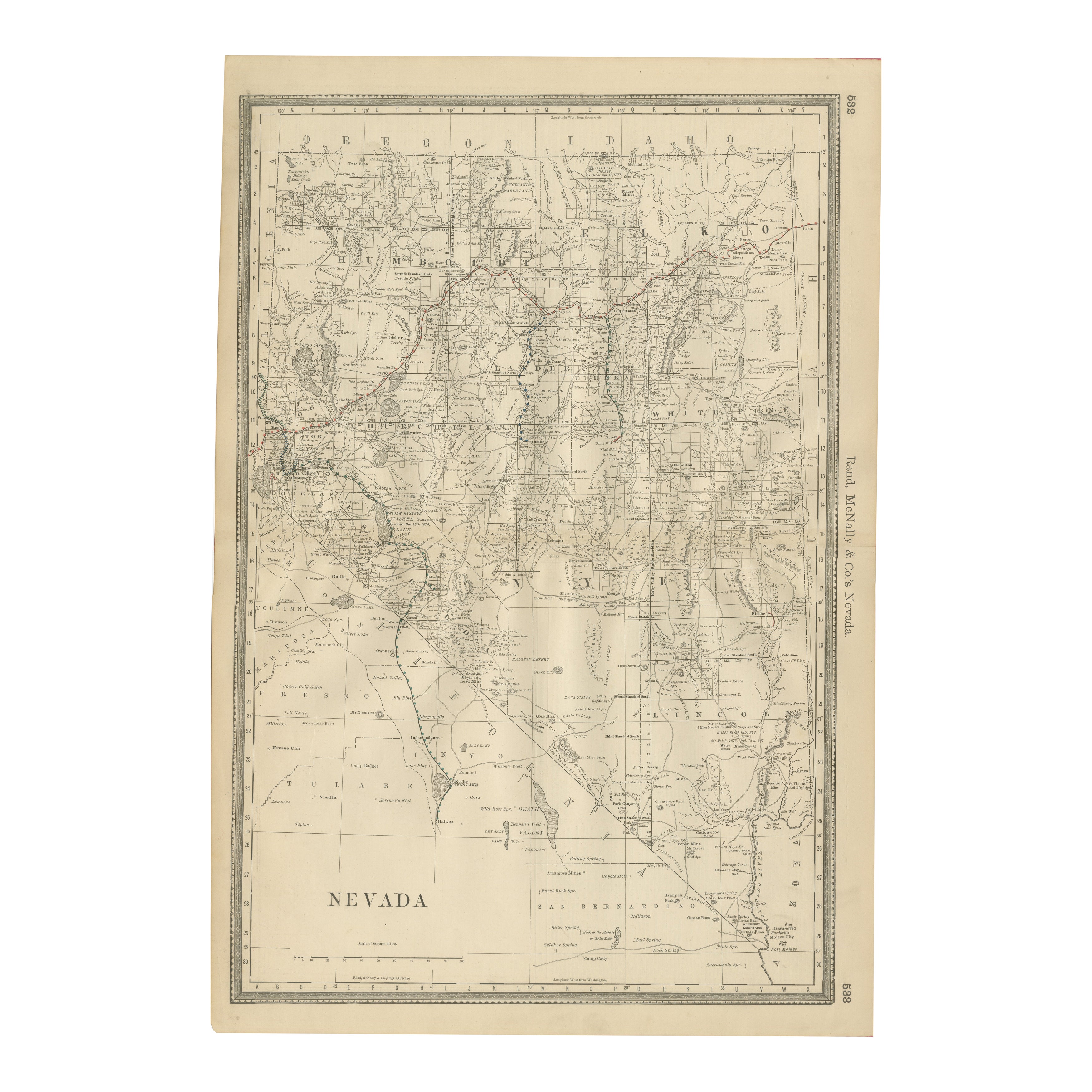
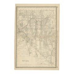
Antique Map of Nevada – Railroads, Mining Camps & Counties, 1888
Located in Langweer, NL
Antique Map of Nevada – Railroads, Mining Camps & Counties, 1888
This antique engraved map depicts the state of Nevada in 1888, engraved and published by Rand, McNally & Co. in Chic...
Category
Antique Late 19th Century American Maps
Materials
Paper
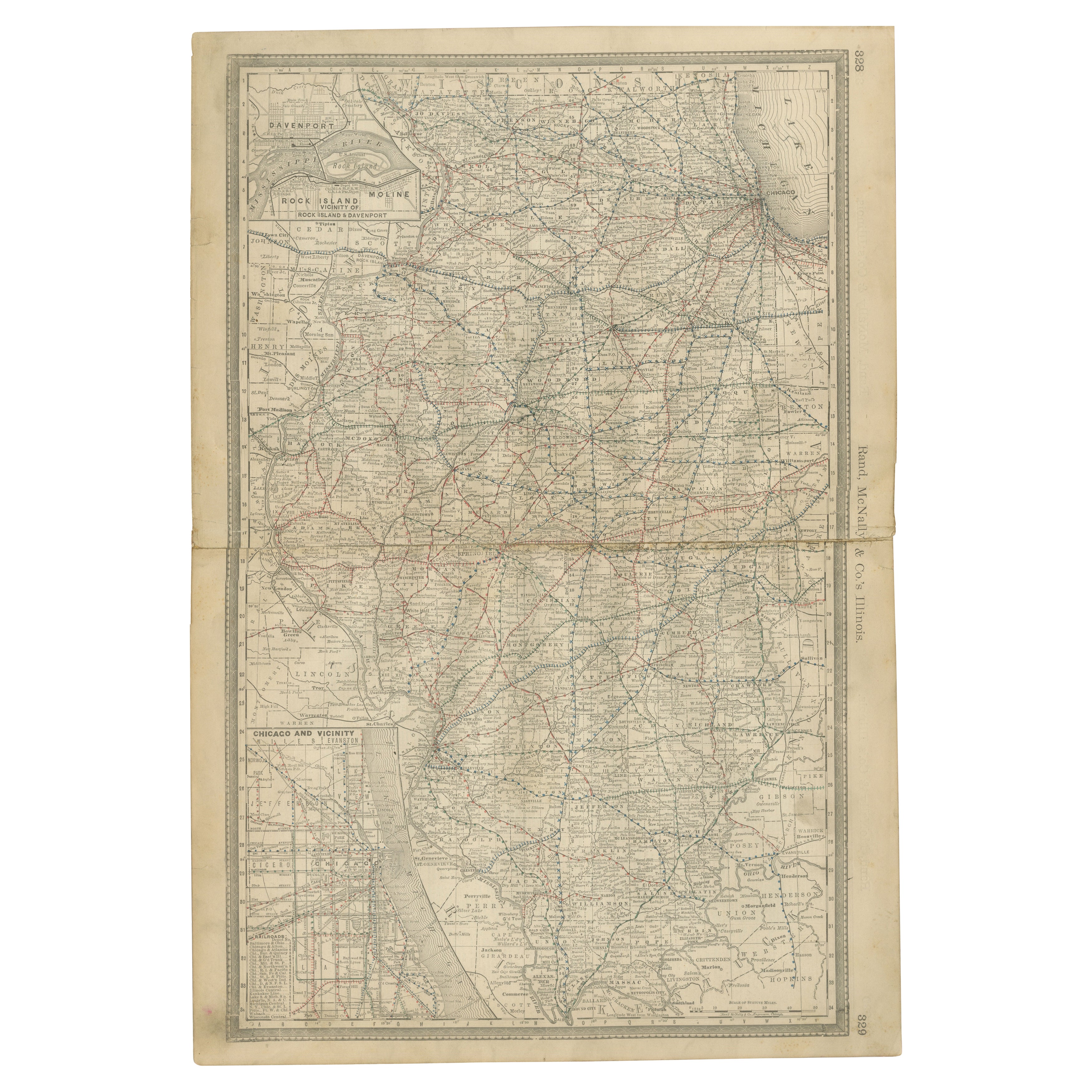
Detailed Antique Map of Illinois – Railroads, Cities & Counties, 1888
Located in Langweer, NL
Antique Map of Illinois – Railroads, Cities & Counties, 1888
This finely detailed antique map shows the state of Illinois in the late 19th century, engraved and published in 1888 by...
Category
Antique Late 19th Century American Maps
Materials
Paper

You May Also Like
1899 Poole Brothers Antique Railroad Map of the Illinois Central Railroad
Located in Colorado Springs, CO
This is an 1899 railroad map of the Illinois Central and Yazoo and Mississippi Valley Railroads, published by the Poole Brothers. The map focuses on the continuous United States from the Atlantic to the Pacific Oceans, the Gulf of Mexico, and the Antilles. Remarkably detailed, the rail routes of the Illinois Central RR are marked in red, which each stop labeled. Major stops are overprinted in red, bold letters, with the short rail distances to New York listed above the stop and short rail distances to New Orleans listed below the name.
In addition to the Illinois Central network, numerous different rail lines are illustrated and the company running that line is noted along with many stops along each route. Sea routes from New Orleans to locations in Central America, the Caribbean, and Europe are marked and labeled with destination and distance, along with routes originating from Havana. Inset at bottom left is a map of Cuba; an inset map of Puerto Rico...
Category
Antique 1890s American Maps
Materials
Paper

Original Antique Map of the American State of Alabama, 1903
Located in St Annes, Lancashire
Antique map of Alabama
Published By A & C Black. 1903
Original colour
Good condition
Unframed.
Free shipping
Category
Antique Early 1900s English Maps
Materials
Paper

Large Original Antique Map of Alabama, USA, C.1900
Located in St Annes, Lancashire
Fabulous map of Alabama
Original color
Engraved and printed by the George F. Cram Company, Indianapolis.
Published, C.1900
Unframed
Repair to a minor edge tear top left corner
...
Category
Antique 1890s American Maps
Materials
Paper
Tony Sarg Map of Nantucket Town, 1937
By Tony Sarg
Located in Nantucket, MA
Tony Sarg Map of Residential Main Street, Nantucket, 1937, a black and white printed map of our historic downtown area, with images of each building, street names and whimsical figur...
Category
Vintage 1930s American Other Maps
Materials
Paper

Original Antique Map of The Philippines. C.1900
Located in St Annes, Lancashire
Fabulous map of The Philippines
Original color.
Engraved and printed by the George F. Cram Company, Indianapolis.
Published, C.1900.
Unframed.
Free shipping.
Category
Antique 1890s American Maps
Materials
Paper

Antique Town Plan Map, Poole, English, Framed Cartography, Georgian, Circa 1780
Located in Hele, Devon, GB
This is an antique town plan map of Poole in Dorset. An English, framed atlas engraving, dating to the 18th century and later.
Fascinating cartography with annotated streets and pl...
Category
Antique Late 18th Century British George III Maps
Materials
Glass, Wood, Paper
