Items Similar to Antique Map of Assam and Bhutan – Hand-Colored Lithograph by Vandermaelen, 1827
Want more images or videos?
Request additional images or videos from the seller
1 of 10
Antique Map of Assam and Bhutan – Hand-Colored Lithograph by Vandermaelen, 1827
$808.73
£601.78
€680
CA$1,111.15
A$1,240.14
CHF 652.46
MX$15,064.29
NOK 8,271.40
SEK 7,741
DKK 5,176.58
About the Item
Antique Map of Assam and Bhutan – Hand-Colored Lithograph by Vandermaelen, 1827
This original antique map titled “Assam et Boutan” (No. 84) is a finely detailed lithograph from the Atlas Universel by Philippe Marie Vandermaelen, published in Brussels in 1827. It presents a rare and early European cartographic view of northeastern India, including the mountainous kingdom of Bhutan and the Brahmaputra River valley in Assam.
The map covers the complex and geographically diverse region at the eastern edge of British India, extending from the Assam plains across the forested hills of Bhutan to the eastern Himalayan ranges bordering Tibet. Prominently labeled are “Pays de Deva Dharma Rajah” (Land of the Deva Dharma Raja), a historical reference to the Bhutanese monarchy, and “Royaume d’Assam ou Ascham,” reflecting the kingdom's political identity before its full absorption into British India.
Key geographic features include the Brahmaputra River system, which meanders dramatically across the map, and numerous mountain chains depicted in shaded relief. Towns, forts, tribal areas, and trading routes are marked, including important locations like Gauhati (Guwahati), Rangamati, Tezpur, and Sadiya. The southern part of the map shows “Gonasse Errimentia” (Cachar region) and portions of “Manipur” and “Morang,” referencing neighboring territories in today’s northeast India and northern Myanmar.
Vandermaelen's maps were among the first to use lithography on a wide scale for cartographic purposes, and this map maintains his hallmark features: uniform scale (1:1,641,836), fine linework, and hand-colored borders to denote regional distinctions. Each sheet from the *Atlas Universel* was designed to be joined into a massive three-dimensional globe, highlighting Vandermaelen’s ambitious vision for a unified cartographic world.
This map is especially valuable for its historical depiction of Bhutan and Assam before British consolidation, offering insight into early 19th-century geographical knowledge and colonial interest in the Himalayan frontier.
Condition: Excellent condition with original hand-color in outline. Light age-toning and minor centerfold creasing as issued. No tears, foxing, or repairs. Strong, stable paper and clean plate impression.
Framing tips: This map pairs beautifully with a light wooden or antique gold frame and a cream or soft moss-green mat to echo the natural tones of the region. Ideal as part of a Himalayan or South Asian-themed map collection.
Technique: Lithograph with original hand color
Maker: Philippe Marie Vandermaelen, Brussels, 1827
- Dimensions:Height: 18.51 in (47 cm)Width: 20.28 in (51.5 cm)Depth: 0.01 in (0.2 mm)
- Materials and Techniques:Paper,Engraved
- Place of Origin:
- Period:
- Date of Manufacture:1827
- Condition:Condition: Excellent condition with original hand-color in outline. Light age-toning and minor centerfold creasing as issued. No tears, foxing, or repairs. Strong, stable paper and clean plate impression.
- Seller Location:Langweer, NL
- Reference Number:Seller: BG-13457-31stDibs: LU3054346159162
About the Seller
5.0
Recognized Seller
These prestigious sellers are industry leaders and represent the highest echelon for item quality and design.
Platinum Seller
Premium sellers with a 4.7+ rating and 24-hour response times
Established in 2009
1stDibs seller since 2017
2,567 sales on 1stDibs
Typical response time: <1 hour
- ShippingRetrieving quote...Shipping from: Langweer, Netherlands
- Return Policy
Authenticity Guarantee
In the unlikely event there’s an issue with an item’s authenticity, contact us within 1 year for a full refund. DetailsMoney-Back Guarantee
If your item is not as described, is damaged in transit, or does not arrive, contact us within 7 days for a full refund. Details24-Hour Cancellation
You have a 24-hour grace period in which to reconsider your purchase, with no questions asked.Vetted Professional Sellers
Our world-class sellers must adhere to strict standards for service and quality, maintaining the integrity of our listings.Price-Match Guarantee
If you find that a seller listed the same item for a lower price elsewhere, we’ll match it.Trusted Global Delivery
Our best-in-class carrier network provides specialized shipping options worldwide, including custom delivery.More From This Seller
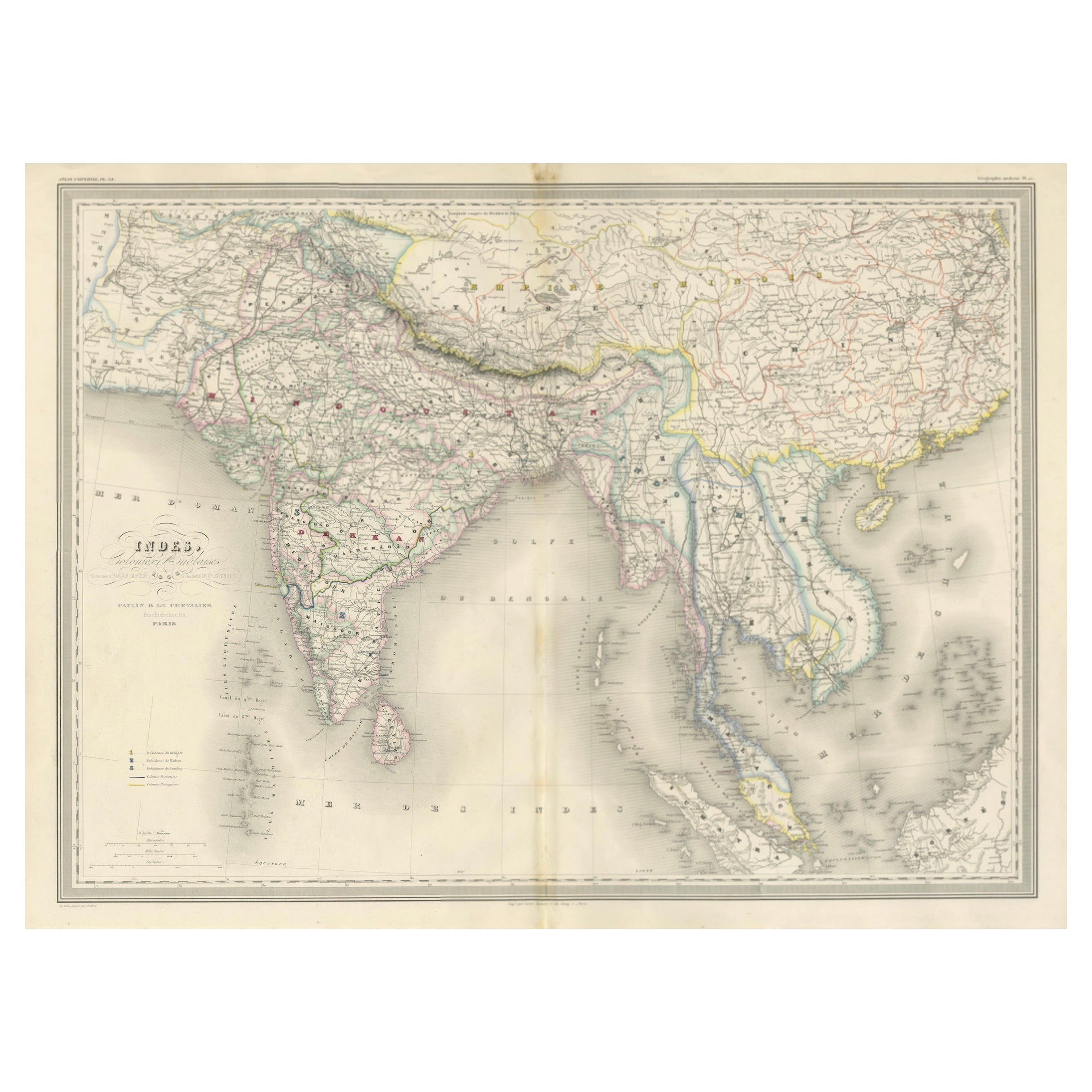
View AllAntique Map of India & Southeast Asia – Chevalier Engraving, Malte-Brun, 1853
Located in Langweer, NL
Antique Map of India and Southeast Asia – Chevalier Engraving from Malte-Brun’s Atlas, 1853
This beautifully engraved map titled “Inde, comprenant les Empires de la Chine, de l’Indo...
Category
Antique Mid-19th Century English Maps
Materials
Paper
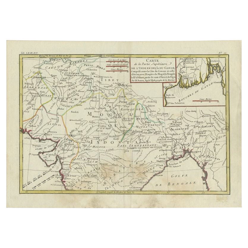
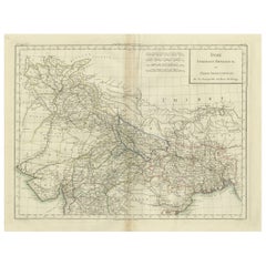
Antique Map of Northern India by Bonne, 1780
Located in Langweer, NL
Antique map titled 'Carte de la partie Supérieure de l'Inde (..)'. A fine example of Rigobert Bonne and Guilleme Raynal?s 1780 map of northern India. Covers the northern part of Indi...
Category
Antique 18th Century Maps
Materials
Paper
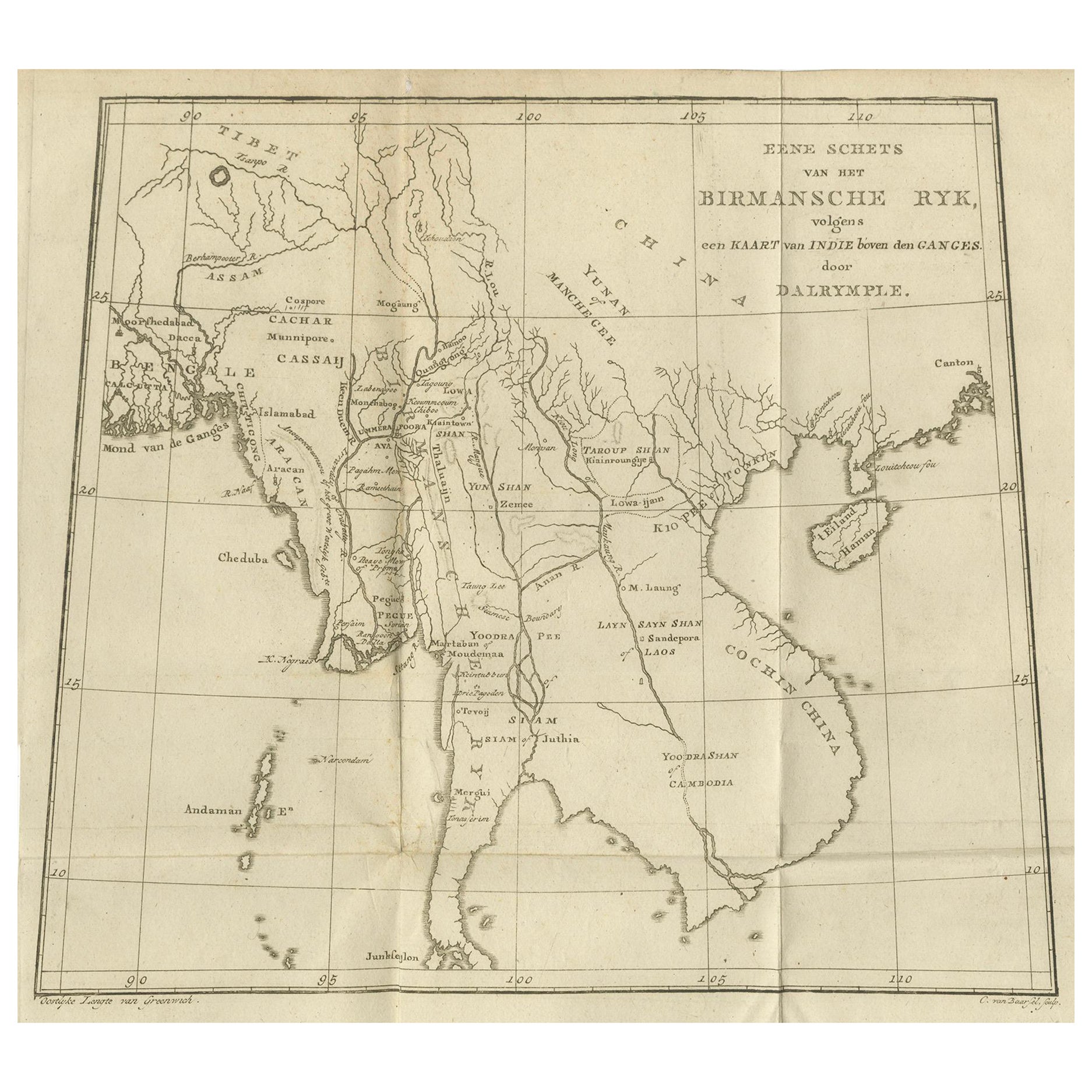
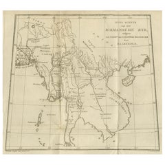
Antique Map of the Burmese Empire and Upper Indochina – by Dalrymple, c.1800
Located in Langweer, NL
Map of the Burmese Empire and Upper Indochina – Dutch Edition after Dalrymple, circa 1800
This antique map titled “Eene Schets van het Birmansche Ryk, volgens een Kaart van Indie bo...
Category
Antique Early 19th Century English Prints
Materials
Paper
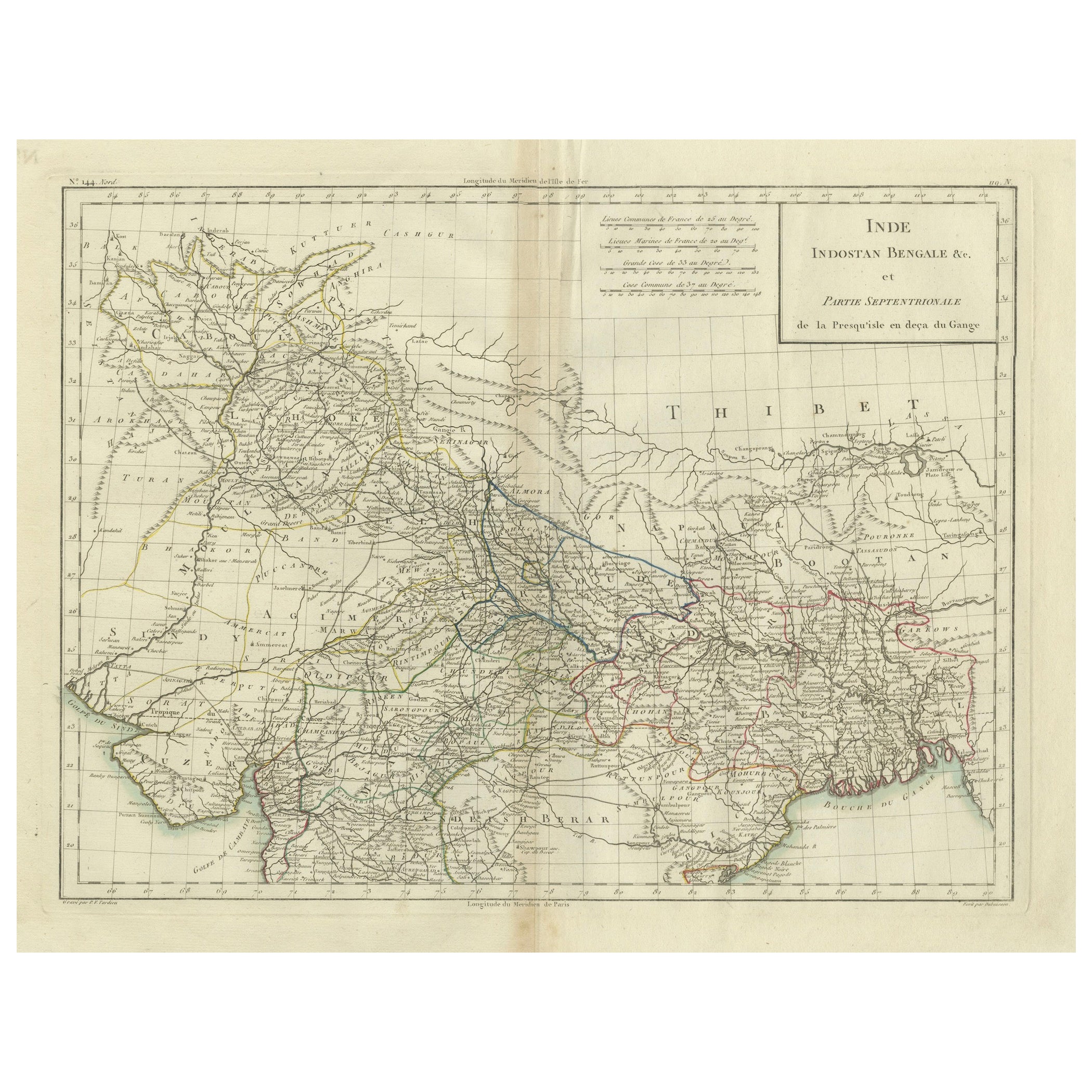
Antique Map of Northern India, Bengal, and Surrounding Regions by Tardieu, 1802
Located in Langweer, NL
This is an original antique map titled "Inde, Indostan Bengale &c. et Partie Septentrionale de la Presqu'isle en deça du Gange," depicting the northern part of the Indian subcontinen...
Category
Antique Early 1800s Maps
Materials
Paper
$418 Sale Price
20% Off
1816 Large Southern Hindostan Map by J. Thomson – New General Atlas
Located in Langweer, NL
Title: 1816 Southern Hindostan Map by J. Thomson – New General Atlas
This map, titled "Southern Hindostan," was published in 1816 as part of J. Thomson’s *New General Atlas*. The ma...
Category
Antique 1810s Maps
Materials
Paper
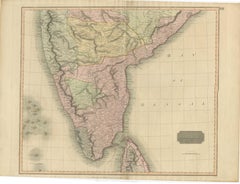
$504 Sale Price
20% Off
Antique Map of Southern India and Ceylon by Thomson, 1816
Located in Langweer, NL
"Antique map titled 'Southern Hindostan'. A map of Southern India and the North of Ceylon. From Thomson's 'New General Atlas', 1816. Artists and Engravers: Engraved by Neele.
Arti...
Category
Antique 19th Century Maps
Materials
Paper
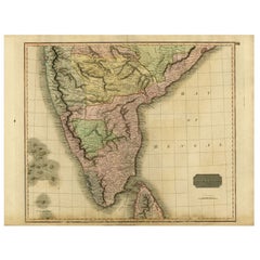
$166 Sale Price
20% Off
You May Also Like
Original Antique Map of India by Dower, circa 1835
Located in St Annes, Lancashire
Nice map of India
Drawn and engraved by J.Dower
Published by Orr & Smith. C.1835
Unframed.
Free shipping
Category
Antique 1830s English Maps
Materials
Paper

Original Antique Map of China, Arrowsmith, 1820
Located in St Annes, Lancashire
Great map of China
Drawn under the direction of Arrowsmith
Copper-plate engraving
Published by Longman, Hurst, Rees, Orme and Brown, 1820
Unfr...
Category
Antique 1820s English Maps
Materials
Paper

India (Southern Sheet), English antique map by Alexander Keith Johnston, 1901
Located in Melbourne, Victoria
'India (Southern Sheet)', antique lithographic map by Keith Johnston.
Inset maps of 'Bombay Island & Town', 'Madras & Environs', and 'South-Eastern Provinces of India'.
Central vertical fold as issued.
495mm by 625mm (sheet)
Alexander Keith...
Category
Early 20th Century Victorian More Prints
Materials
Lithograph

Map of the East Indies: An Original 18th Century Hand-colored Map by E. Bowen
Located in Alamo, CA
This is an original 18th century hand-colored map entitled "An Accurate Map of the East Indies Exhibiting the Course of the European Trade both on the Continent and Islands" by Emanu...
Category
Mid-18th Century Old Masters Landscape Prints
Materials
Engraving

Asia Declineatio: A 17th Century Hand-colored Map of Asia by Justus Danckerts
Located in Alamo, CA
This is a scarce 17th century beautifully hand-colored copperplate engraved map of Asia entitled “Exactissima Asiae Delineatio in Praecipuas Regiones Caerterasque Partes divisa et de...
Category
Late 17th Century Old Masters Landscape Prints
Materials
Engraving

Antique 1803 Italian Map of Asia Including China Indoneseia India
Located in Amsterdam, Noord Holland
Antique 1803 Italian Map of Asia Including China Indoneseia India
Very nice map of Asia. 1803.
Additional information:
Type: Map
Country of Manufacturing: Europe
Period: 19th centu...
Category
Antique 19th Century European Maps
Materials
Paper

$584 Sale Price
20% Off