Items Similar to Antique Map of the Caribbean & Central America – West Indies, 1857


Video Loading
Want more images or videos?
Request additional images or videos from the seller
1 of 11
Antique Map of the Caribbean & Central America – West Indies, 1857
$495.02
£372.85
€420
CA$682.66
A$766.93
CHF 400.72
MX$9,360.78
NOK 5,088.02
SEK 4,789.30
DKK 3,196.88
About the Item
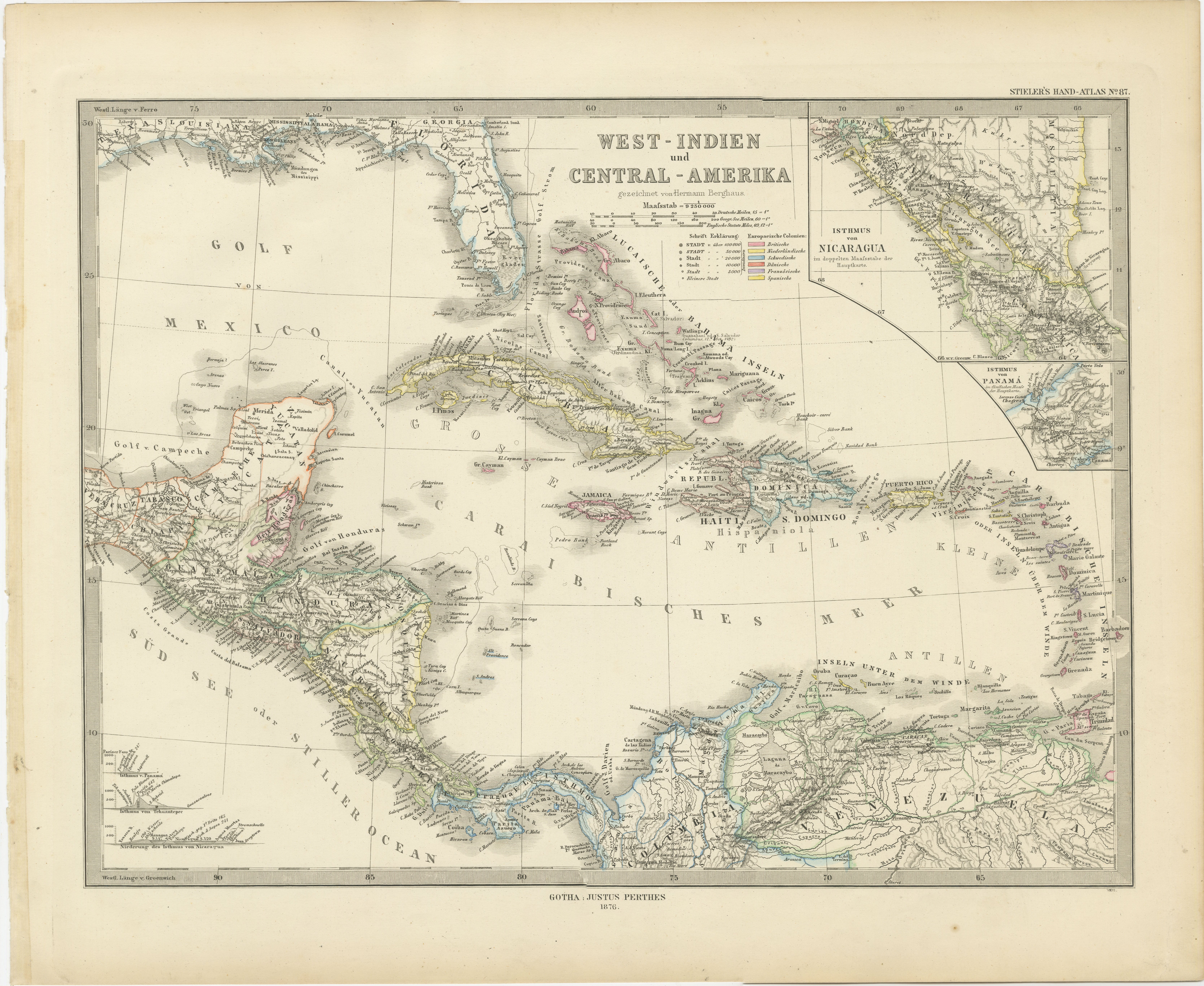
Antique Map of the Caribbean & Central America – West Indies, 1857
This finely engraved and hand-colored map titled "West-Indien und Centro-America" was published in 1857 by Justus Perthes in Gotha and drawn by F. von Stülpnagel. It offers a beautifully detailed view of the Caribbean region and the connecting lands of Central America, during a pivotal time in 19th-century colonial and maritime history.
The map covers a broad swath of territory including Cuba, Jamaica, Hispaniola (Haiti and the Dominican Republic), Puerto Rico, the Bahamas, and the Lesser Antilles stretching toward Trinidad and the Venezuelan coast. Central America is rendered in fine detail, from southern Mexico through Guatemala, Honduras, Nicaragua, Costa Rica, and Panama, all annotated with extensive place names, rivers, and political boundaries of the era.
Inset maps include:
– The city and harbor of Havana
– The islands of Guadeloupe
– The island of Martinique
– A section of the Yucatán peninsula
The color coding indicates the colonial possessions of major European powers at the time, including Spanish, British, French, Dutch, and Danish territories. This classification provides insights into the geopolitical complexity of the Caribbean before the full wave of independence movements in the region.
Notably, the map includes precise topographical elements and German annotations for towns, ports, capes, and waterways, reflecting the cartographic excellence typical of mid-19th-century German atlases.
Collectors of Caribbean history, maritime cartography, or colonial studies will appreciate the historical and visual richness of this plate, which comes from Stieler’s Hand-Atlas, one of the most influential atlases of the 19th century.
Condition report:
Very good condition with light age toning. Minor margin wear. Strong plate impression, vibrant original hand-coloring.
Framing tips:
Pair with a deep walnut or dark wood frame and a warm-toned mat to enhance the Caribbean hues and bring out the delicate labeling. Ideal for libraries, coastal homes, or historical collections.
Technique: Engraving with original hand coloring
Maker: F. von Stülpnagel / Justus Perthes, Gotha, 1857
- Dimensions:Height: 14.77 in (37.5 cm)Width: 17.88 in (45.4 cm)Depth: 0.01 in (0.2 mm)
- Materials and Techniques:Paper,Engraved
- Place of Origin:
- Period:
- Date of Manufacture:1857
- Condition:Very good condition with light age toning. Minor margin wear. Strong plate impression, vibrant original hand-coloring.
- Seller Location:Langweer, NL
- Reference Number:Seller: BG-05552-541stDibs: LU3054346102042
About the Seller
5.0
Recognized Seller
These prestigious sellers are industry leaders and represent the highest echelon for item quality and design.
Platinum Seller
Premium sellers with a 4.7+ rating and 24-hour response times
Established in 2009
1stDibs seller since 2017
2,533 sales on 1stDibs
Typical response time: <1 hour
- ShippingRetrieving quote...Shipping from: Langweer, Netherlands
- Return Policy
Authenticity Guarantee
In the unlikely event there’s an issue with an item’s authenticity, contact us within 1 year for a full refund. DetailsMoney-Back Guarantee
If your item is not as described, is damaged in transit, or does not arrive, contact us within 7 days for a full refund. Details24-Hour Cancellation
You have a 24-hour grace period in which to reconsider your purchase, with no questions asked.Vetted Professional Sellers
Our world-class sellers must adhere to strict standards for service and quality, maintaining the integrity of our listings.Price-Match Guarantee
If you find that a seller listed the same item for a lower price elsewhere, we’ll match it.Trusted Global Delivery
Our best-in-class carrier network provides specialized shipping options worldwide, including custom delivery.More From This Seller
View AllOriginal Antique Map of the West Indies by J. Arrowsmith, 1842
Located in Langweer, NL
Title: "J. Arrowsmith's 19th Century Map of the West Indies"
This original antique map, crafted by J. Arrowsmith, details the West Indies with a focus on the Caribbean Sea and its s...
Category
Antique Early 19th Century Maps
Materials
Paper

1880 Map of the Caribbean and Central America by Adolf Stieler
Located in Langweer, NL
This is a detailed map titled "West-Indien und Central-Amerika," created by Adolf Stieler and published in Gotha in 1880. The map covers the Caribbean islands and the Central America...
Category
Antique 1880s Maps
Materials
Paper
$273 Sale Price
20% Off
1864 Johnson's Map of the West Indies and Bermuda
Located in Langweer, NL
Title: 1864 Johnson's Map of the West Indies and Bermuda
Description: This is an 1864 map titled "Johnson's West Indies," published by Johnson and Ward. The map provides a detailed ...
Category
Antique 1860s Maps
Materials
Paper
$301 Sale Price
20% Off
Antique Map of the West Indies and Central America by W. G. Blackie, 1859
Located in Langweer, NL
Antique map titled 'The West India Island & Central America'. Original antique map of the West Indies and Central America, with inset map of Jamaica. Th...
Category
Antique Mid-19th Century Maps
Materials
Paper

$235 Sale Price
20% Off
Antique Map of the Antilles and Central America – 1872
Located in Langweer, NL
Title: Antique Map of the Antilles and Central America – 1872
Description:
This finely detailed antique map, titled Antilles et Amérique Centrale, was published in 1872 under t...
Category
Antique 1870s Maps
Materials
Paper

Antique Map of the Antilles in the Caribbean, '1875'
Located in Langweer, NL
Antique map titled 'Carte des Iles Antilles'. Large map of the Antilles. This map originates from 'Atlas de Géographie Moderne Physique et Politique' by A. Levasseur. Published, 1875.
Category
Antique Late 19th Century Maps
Materials
Paper

$353 Sale Price
40% Off
You May Also Like
Original Antique Map of Central America / Florida, Arrowsmith, 1820
Located in St Annes, Lancashire
Great map of Central America.
Drawn under the direction of Arrowsmith.
Copper-plate engraving.
Published by Longman, Hurst, Rees, Orme and Brown, 1820
Unframed.
Category
Antique 1820s English Maps
Materials
Paper

Large Original Antique Map of The West Indies by Sidney Hall, 1847
Located in St Annes, Lancashire
Great map of The West Indies
Drawn and engraved by Sidney Hall
Steel engraving
Original colour outline
Published by A & C Black. 1847
Unframed
Free shipping.
Category
Antique 1840s Scottish Maps
Materials
Paper

Early 19th Century Hand Colored Map of the United States and Caribbean Islands
Located in Hamilton, Ontario
Hand coloured early 19th century map by Giraldon of France titled "Etats Unis et Grandes Antilles" (United States and Greater Antilles).
Category
Antique Early 19th Century French Maps
Materials
Paper

$595 Sale Price
40% Off
Central America. Century Atlas antique vintage map
Located in Melbourne, Victoria
'The Century Atlas. Central America.'
Original antique map, 1903.
Inset maps of 'The Country around Lake Nicaragua'.
Central fold as issued. Map name and number printed on the reve...
Category
Early 20th Century Victorian More Prints
Materials
Lithograph

Original Antique Map of The Western Hemisphere by Dower, circa 1835
Located in St Annes, Lancashire
Nice map of the Western Hemisphere
Drawn and engraved by J.Dower
Published by Orr & Smith. C.1835
Unframed.
Free shipping
Category
Antique 1830s English Maps
Materials
Paper

Original Antique Map of North America by Dower, circa 1835
Located in St Annes, Lancashire
Nice map of North America
Drawn and engraved by J.Dower
Published by Orr & Smith. C.1835
Unframed.
Free shipping
Category
Antique 1830s English Maps
Materials
Paper
