Items Similar to Antique Map of the City of Antwerpen ‘Belgium’ by A. Deur, 1729
Want more images or videos?
Request additional images or videos from the seller
1 of 6
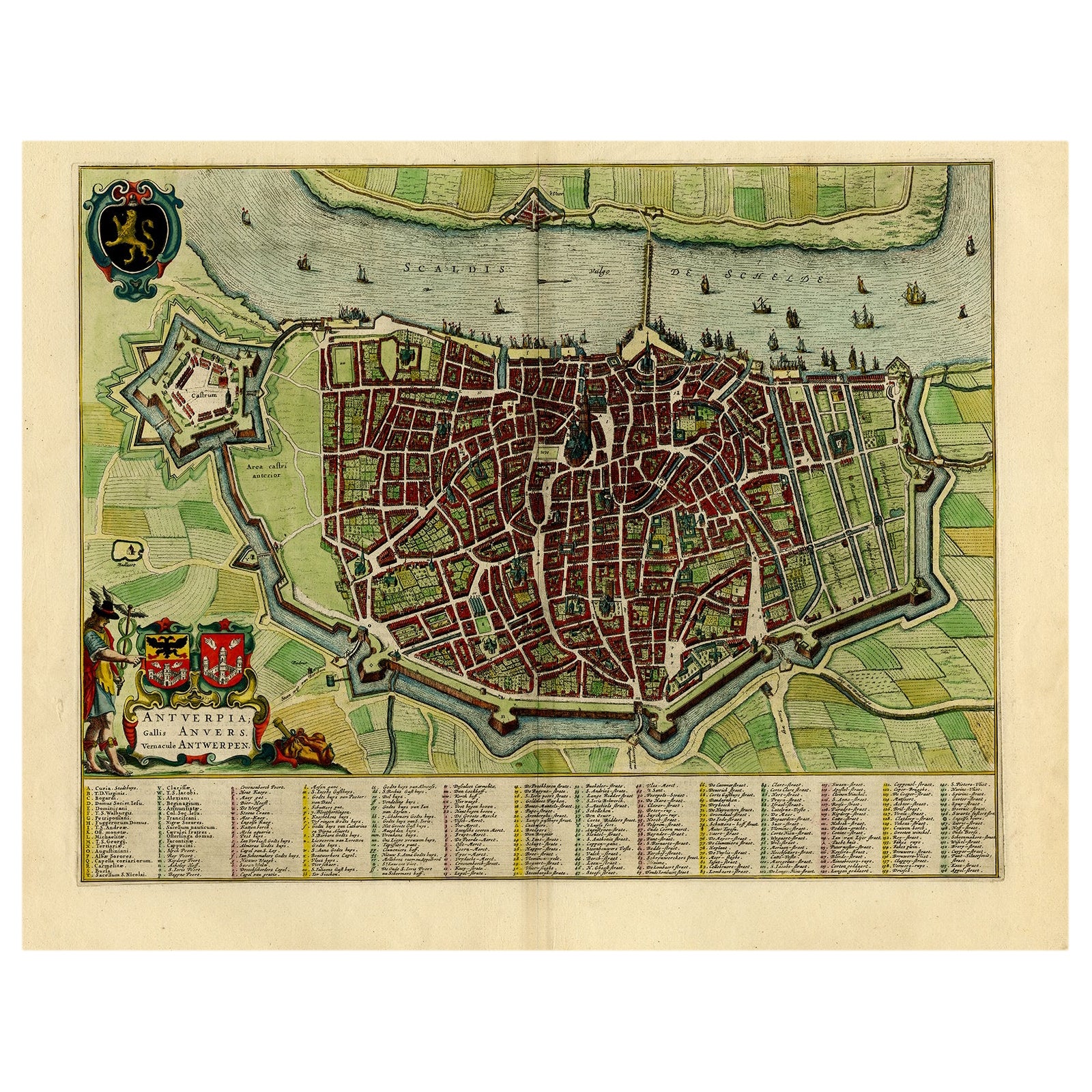
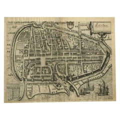
Antique Map of the City of Antwerpen ‘Belgium’ by A. Deur, 1729
$717.45
$896.8120% Off
£543.49
£679.3620% Off
€616
€77020% Off
CA$993.93
CA$1,242.4120% Off
A$1,114.76
A$1,393.4520% Off
CHF 583.78
CHF 729.7320% Off
MX$13,545.41
MX$16,931.7620% Off
NOK 7,413.06
NOK 9,266.3220% Off
SEK 7,028.10
SEK 8,785.1220% Off
DKK 4,690.08
DKK 5,862.6020% Off
About the Item
Copper-engraving by A. Deur. Published by I. van der Kloot in Den Haag, 1729. With French and Dutch title-cartouches and explanatory notes, several ships on the Scheldt river and inset map of "Marquisat du St. Empire d'Anvers".
- Dimensions:Height: 20.28 in (51.5 cm)Width: 24.02 in (61 cm)Depth: 0.02 in (0.5 mm)
- Materials and Techniques:
- Period:
- Date of Manufacture:1729
- Condition:Please study image carefully.
- Seller Location:Langweer, NL
- Reference Number:Seller: BGI-000991stDibs: LU305439104851
About the Seller
5.0
Recognized Seller
These prestigious sellers are industry leaders and represent the highest echelon for item quality and design.
Platinum Seller
Premium sellers with a 4.7+ rating and 24-hour response times
Established in 2009
1stDibs seller since 2017
2,517 sales on 1stDibs
Typical response time: <1 hour
- ShippingRetrieving quote...Shipping from: Langweer, Netherlands
- Return Policy
Authenticity Guarantee
In the unlikely event there’s an issue with an item’s authenticity, contact us within 1 year for a full refund. DetailsMoney-Back Guarantee
If your item is not as described, is damaged in transit, or does not arrive, contact us within 7 days for a full refund. Details24-Hour Cancellation
You have a 24-hour grace period in which to reconsider your purchase, with no questions asked.Vetted Professional Sellers
Our world-class sellers must adhere to strict standards for service and quality, maintaining the integrity of our listings.Price-Match Guarantee
If you find that a seller listed the same item for a lower price elsewhere, we’ll match it.Trusted Global Delivery
Our best-in-class carrier network provides specialized shipping options worldwide, including custom delivery.More From This Seller
View AllBeautiful Original Antique Map of Antwerp, Belgium by Mapmaker Blaeu, ca.1652
Located in Langweer, NL
Description: Antique map titled 'Antverpia; Gallis Anvers. Vernacule Antwerpen.'
A very nicely coloured plan of Antwerp in Flanders, Belgium. West-oriented, with the river Scheld...
Category
Antique 1650s Maps
Materials
Paper
$2,329 Sale Price
20% Off
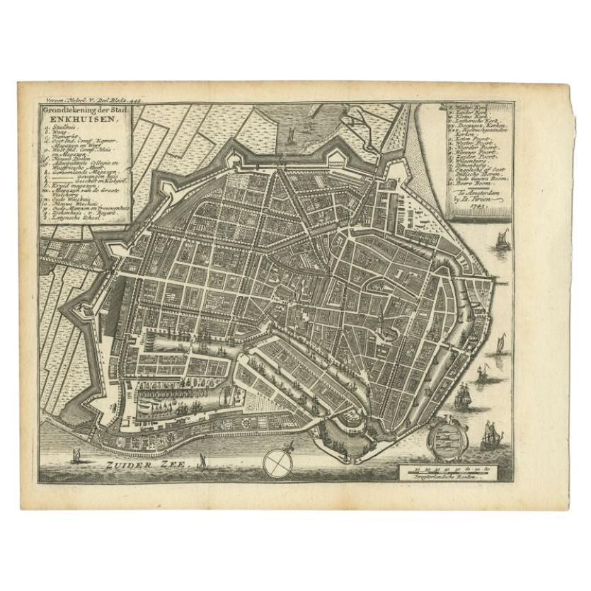
Antique Map of the City of Enkhuizen by Tirion, 1743
Located in Langweer, NL
Antique map titled ?Grondtekening der Stad Enkhuisen?. Beautiful map of the City of Enkhuizen. With Dutch legend. Decorated with compass rose, several ships and the city-arms. Artist...
Category
Antique 18th Century Maps
Materials
Paper
$139 Sale Price
20% Off
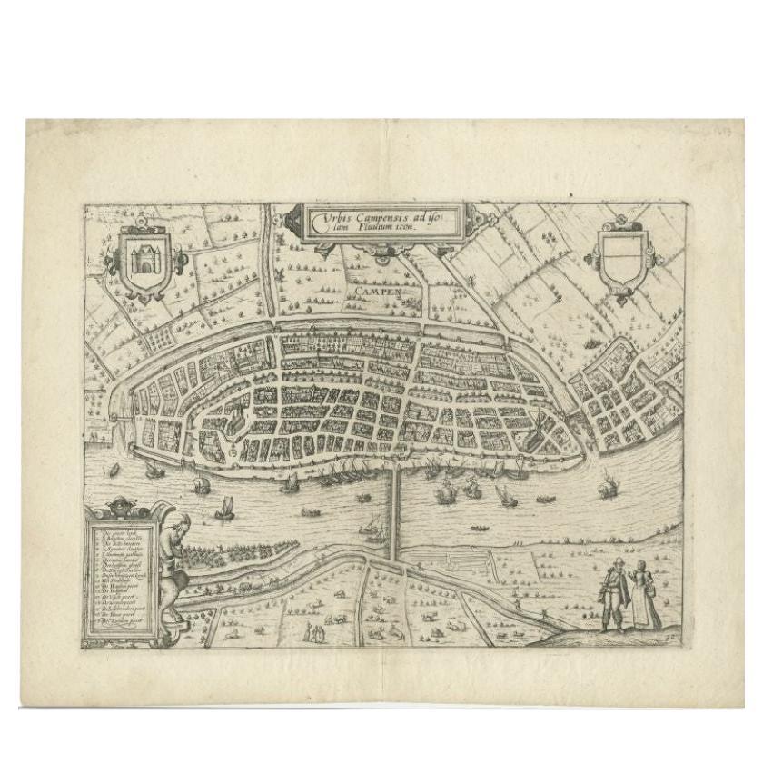
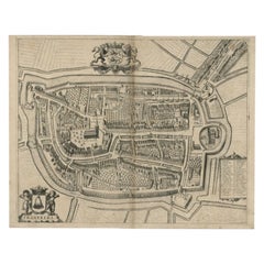
Antique Map of the City of Kampen by Guicciardini, 1613
Located in Langweer, NL
Antique map titled 'Urbis Campensis (..)'. Plan of the city of Kampen, the Netherlands. This map originates from the 1613 edition of 'Discrittione di tutti i Paesi Bassi', by L. Guic...
Category
Antique 17th Century Maps
Materials
Paper

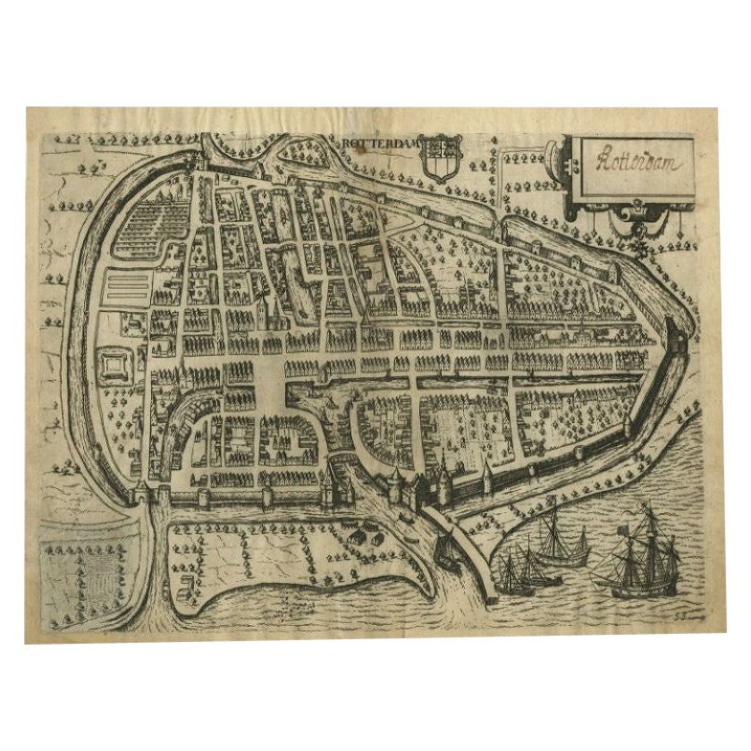
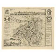
Antique Map of the City of Rotterdam by Guicciardini, C.1600
Located in Langweer, NL
Antique map titled 'Rotterdam'. Bird's eye view plan of Rotterdam in the province of Zuid-Holland, The Netherlands, Holland. This map originates from one of the editions of 'Discritt...
Category
Antique 17th Century Maps
Materials
Paper
$368 Sale Price
20% Off
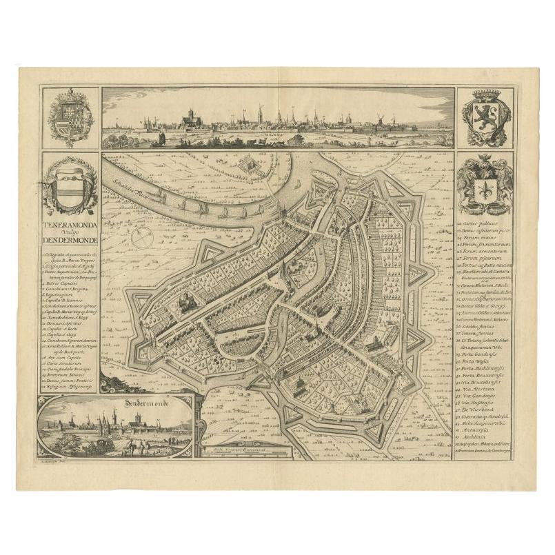
Beautiful Antique Map with Views of Dendermonde, Belgium, 1735
Located in Langweer, NL
Antique map titled 'Teneramonda vulgo Dendermonde'. Beautiful map with views of Dendermonde, Belgium. This map originates from 'Flandria illustrata, sive provinciae ac comitatus huju...
Category
Antique 18th Century Prints
Materials
Paper
$605 Sale Price
20% Off
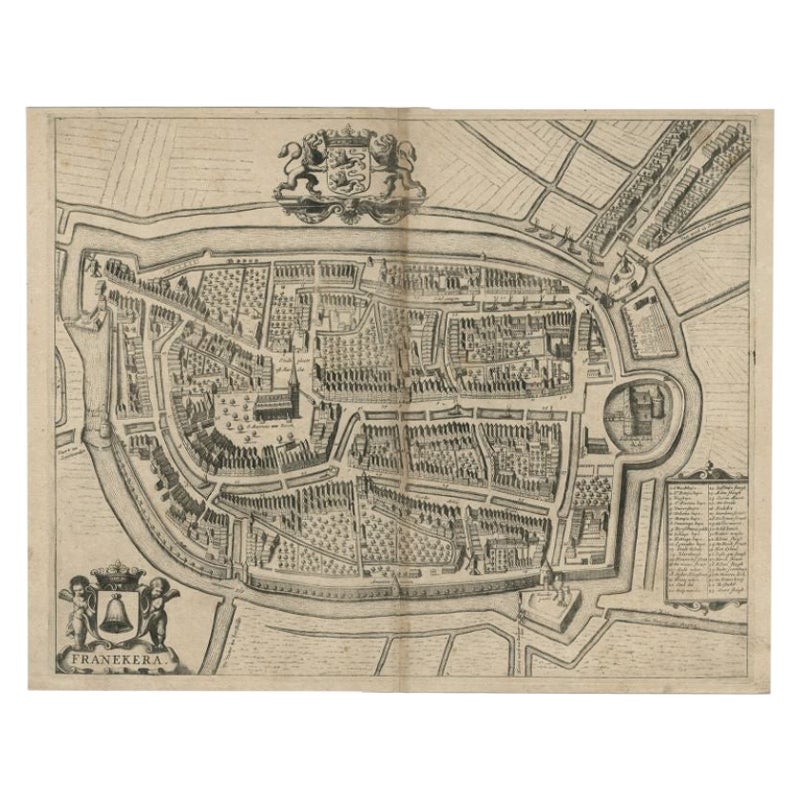
Antique Map of the City of Franeker by Janssonius, 1657
By Johannes Janssonius
Located in Langweer, NL
Antique map titled ‘Franekera‘. This map depicts the city of Franeker (Friesland, The Netherlands). Published by J. Janssonius, Amsterdam, 1657.
Artists and Engravers: Johannes Jans...
Category
Antique 17th Century Maps
Materials
Paper
You May Also Like
18th Century Map Engraving - Newport, a Strong Sea-Port Town in Flanders
Located in Corsham, GB
A map of Nieuwpoort, anglicised to 'Newport', in northern Belgium. There is a panorama in the upper quarter depicting major landmarks. Below is a plan of the town, including its strong defences and ships at the port in the lower register. Inscribed with the title in plate to the lower edge, 'Newport a Strong Sea-Port Town...
Category
18th Century More Prints
Materials
Engraving

$269 Sale Price
20% Off
Original Antique Map or City Plan of Amsterdam, Netherlands. Circa 1835
Located in St Annes, Lancashire
Nice map of Amsterdam
Drawn and engraved by J.Dower
Published by Orr & Smith. C.1835
Unframed.
Free shipping
Category
Antique 1830s English Maps
Materials
Paper

Utrecht, Antique Map from "Civitates Orbis Terrarum"
By Franz Hogenberg
Located in Roma, IT
Braun G., Hogenberg F., Traiectum or Utrecht, from the collection Civitates Orbis Terrarum, Cologne, T. Graminaeus, 1572-1617.
Very fine B/W aquatint showing a view of Utrecht, with...
Category
16th Century Landscape Prints
Materials
Etching

18th Century Map Engraving - Mechlin, or Malines
Located in Corsham, GB
A map of Mechelen, known as Malines in French and Mechlin in English, a city and municipality in the province of Antwerp in the Flemish Region of Belgium. A birds-eye view plan of th...
Category
18th Century More Prints
Materials
Engraving

$269 Sale Price
20% Off
17th Century Toulouse, Savve, Sommieres Topographical Map by Iohan Peeters
Located in New York, NY
Fine topographical 17th century map of Toulouse, Savve and Sommieres by Iohan Peeters
Beautiful engraving of the capital of France's Occitanie Region, Toulouse, called La Ville Rose- the Pink City, for the terracotta bricks used in its many buildings, giving the city a distinct apricot-rose hue. An important cultural and educational center, the city's residents included Nobel Prize winners and world renown artists- Henri de Toulouse-Lautrec, Henri Martin, Jean-Auguste-Dominique Ingres, Antonin Mercie, Alexandre Falguiere and more recently Cyril Kongo...
Category
Antique 17th Century Dutch Maps
Materials
Paper

Map of Nijmegen - Etching by G. Braun and F. Hogenberg - Late 16th Century
By Franz Hogenberg
Located in Roma, IT
This map of Noviomagvs is an original etching realized by Georg Braun and Franz Hogenberg as part of the famous series "Civitates Orbis Terrarum".
The state of preservation of the ...
Category
16th Century Figurative Prints
Materials
Etching

More Ways To Browse
Gold Modern Coffee Table
Large Side Tables
Japanese Silver Ceramics
One Of A Kind Chair
Used Oak Dining Room Chairs
17th Century Plate
Childrens Vintage Poster
Chinese Ship
Vintage Travel Poster Mid Century
Desk Key
Woven Silk Art
Carved Cabriole Table
Dark Antique Table
White Wooden Table
Antique Wall Table
1960 Chair Wood Danish
Unusual Dining Table
Antique Dutch Plates