Items Similar to Antique Map of the Coast of Peru and Chile – Detailing Ports & Coastlines, c1760


Want more images or videos?
Request additional images or videos from the seller
1 of 10
Antique Map of the Coast of Peru and Chile – Detailing Ports & Coastlines, c1760
$548.20
£405.98
€460
CA$755.26
A$839.72
CHF 442.16
MX$10,188.30
NOK 5,597.99
SEK 5,232.76
DKK 3,501.44
About the Item
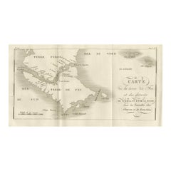
Map of the Coast of Peru and Chile – “Côte du Pérou et Côte du Chili”, c.1760
This 18th-century copperplate engraving presents a detailed chart of the Pacific coastline from northern Peru to southern Chile. Titled Côte du Pérou et Côte du Chili and marked “Tome 6” in the upper right, the map covers a vast stretch of the South American west coast, extending from Paita in northern Peru down to the island of Chiloé in southern Chile.
Major coastal towns and ports are labeled, including Lima (Capitale du Pérou), La Callao, Pisco, Arequipa, Arica, Iquique, Copiapó, Coquimbo (de la Serena), Santiago (Capitale du Chili), Valparaiso, Concepción, Imperial, Valdivia, and Chiloé. Offshore islands such as the Lobos Islands, La Mocha, and Quiriquina are noted. Geographic markers include the Tropique du Capricorne and a fleur-de-lis north arrow, with an Échelle de 100 Lieues scale at the bottom.
The coastline is rendered with a fine engraved line, showing bays, headlands, and the relative positioning of ports along the Pacific. While inland detail is minimal, the Andes are indicated in the area of Iquique, hinting at the dramatic geography just beyond the coastal strip.
Engraved by Porlier (Porlier Sculp), this map reflects the European interest in maritime routes and colonial territories of the Pacific during the mid-18th century, a period when Spain’s South American possessions were central to global trade via the Manila galleons and other transoceanic connections. Such maps would have been invaluable to merchants, naval officers, and scholars studying geography and trade.
Condition: Very good for age, with a central fold as issued. Light toning and faint foxing in margins. Strong plate impression with crisp coastal detail.
Framing tips: A black or deep mahogany frame with an ivory mount would emphasize the clean lines of the map. For thematic display, it pairs well with other 18th-century maritime charts of the Pacific coast or Spanish colonial territories.
Technique: Copperplate engraving
Maker: A. Porlier, French school, c.1760
- Dimensions:Height: 12.05 in (30.6 cm)Width: 7.88 in (20 cm)Depth: 0.01 in (0.2 mm)
- Materials and Techniques:Paper,Engraved
- Place of Origin:
- Period:
- Date of Manufacture:circa 1760
- Condition:Condition: Very good for age, with a central fold as issued. Light toning and faint foxing in margins. Strong plate impression with crisp coastal detail.
- Seller Location:Langweer, NL
- Reference Number:Seller: BG-14078-281stDibs: LU3054346217912
About the Seller
5.0
Recognized Seller
These prestigious sellers are industry leaders and represent the highest echelon for item quality and design.
Platinum Seller
Premium sellers with a 4.7+ rating and 24-hour response times
Established in 2009
1stDibs seller since 2017
2,569 sales on 1stDibs
Typical response time: <1 hour
- ShippingRetrieving quote...Shipping from: Langweer, Netherlands
- Return Policy
Authenticity Guarantee
In the unlikely event there’s an issue with an item’s authenticity, contact us within 1 year for a full refund. DetailsMoney-Back Guarantee
If your item is not as described, is damaged in transit, or does not arrive, contact us within 7 days for a full refund. Details24-Hour Cancellation
You have a 24-hour grace period in which to reconsider your purchase, with no questions asked.Vetted Professional Sellers
Our world-class sellers must adhere to strict standards for service and quality, maintaining the integrity of our listings.Price-Match Guarantee
If you find that a seller listed the same item for a lower price elsewhere, we’ll match it.Trusted Global Delivery
Our best-in-class carrier network provides specialized shipping options worldwide, including custom delivery.More From This Seller
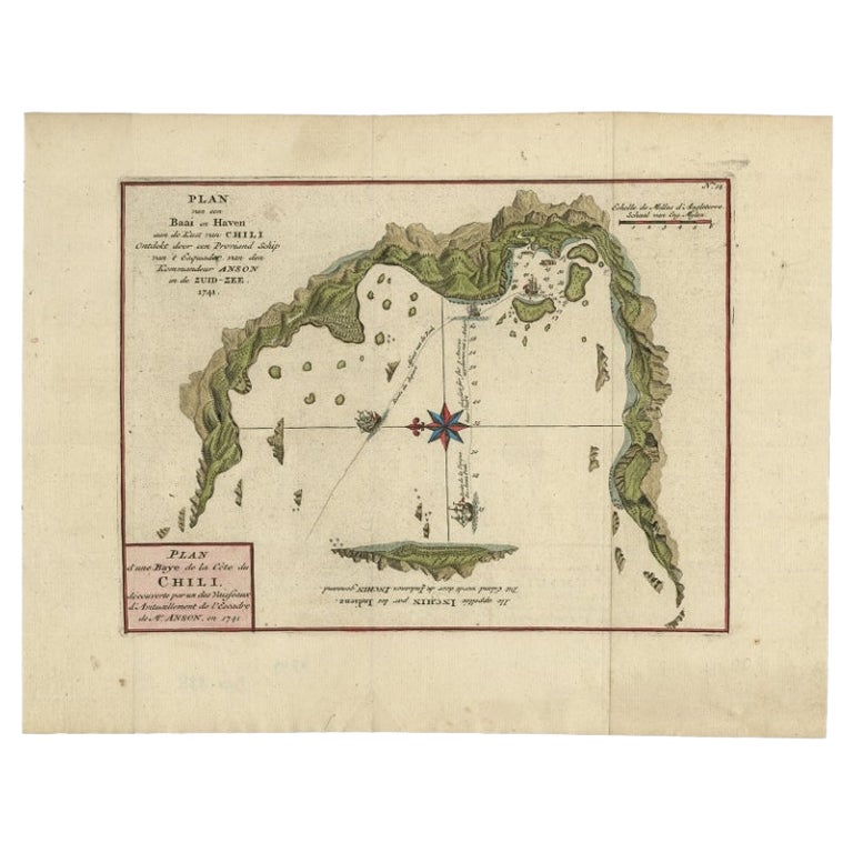
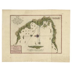
View AllAntique Map of a Bay on the Coast of Chile, South America, c.1749
Located in Langweer, NL
Antique map titled 'Plan van een Baai en Haven aan de Kust van Chili (..) - Plan d'une Baye de la Côte du Chili (..)'. Original antique map of a bay on the coast of Chile discovered ...
Category
Antique 18th Century Maps
Materials
Paper

$305 Sale Price
20% Off
Antique Map of South America by J. Cook (1775)
Located in Langweer, NL
Antique map titled 'Kaart van het Zuidlyk Eind van Amerika'. Map of the sourthern part of South America, focusing on Cook's tracks around the Cape Horn and Tierra del Fuego in 1775. ...
Category
Antique Late 18th Century Maps
Materials
Paper

$563 Sale Price
20% Off
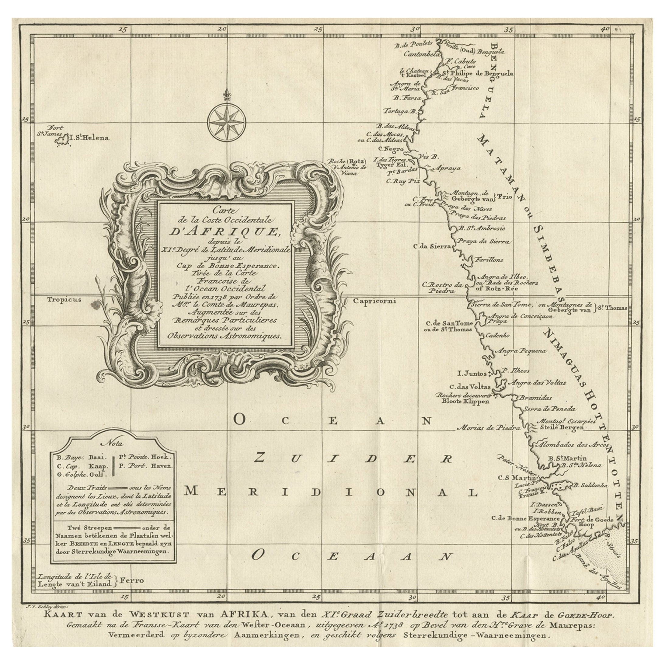
Dutch Antique Map of the West Coast of Africa, to the Cape of Good Hope, 1747
Located in Langweer, NL
Antique map of the Coast of Africa titled 'Kaart van de West Kust van Afrika (..)'.
Map of the west coast of Africa, from 11 degrees south latitude to the Cape of Good Hope. This...
Category
Antique 1740s Maps
Materials
Paper
$371 Sale Price
20% Off
Free Shipping
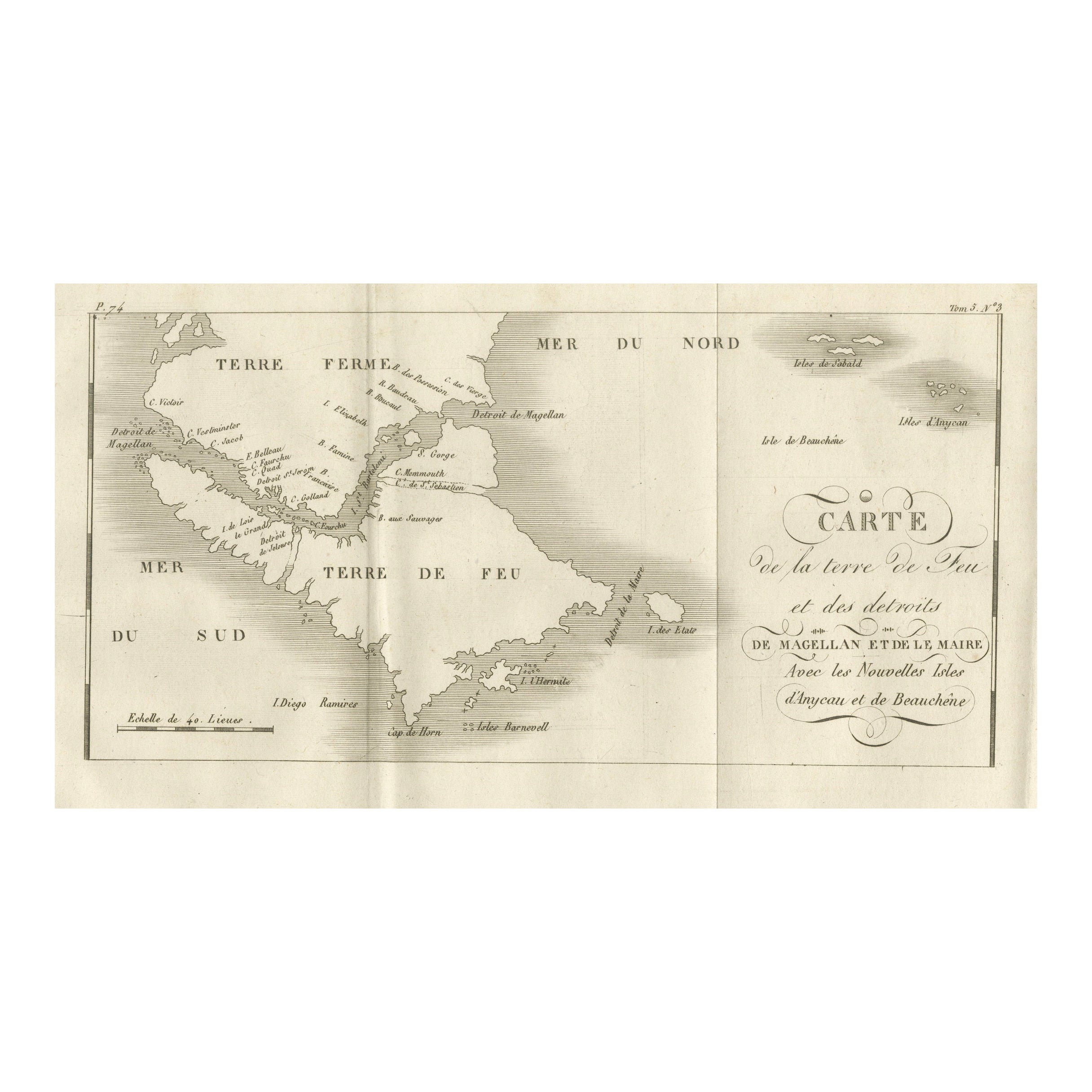
Map of Tierra del Fuego and the Straits of Magellan and Le Maire, c.1760
Located in Langweer, NL
Map of Tierra del Fuego and the Straits of Magellan and Le Maire, c.1760
This 18th-century copperplate map, titled Carte de la Terre de Feu et des Détroits de Magellan et de le Mair...
Category
Antique Mid-18th Century French Maps
Materials
Paper
Antique Map of the Coast of Juan Fernandez by Van Schley, 1757
Located in Langweer, NL
Antique map titled 'Cote du Nord Est de l'Isle de Juan Fernandez (..).' Map of the Chilean South Pacific archipelago of the Juan Fernandez Islands. This island was made famous by Dan...
Category
Antique 18th Century Maps
Materials
Paper

$136 Sale Price
20% Off
Chile Coast Bay Map – Antique 1749 Chart by Anson from Voyage Around the World
Located in Langweer, NL
Antique map titled 'Plan van een Baai en Haven aan de Kust van Chili (..) - Plan d'une Baye de la Côte du Chili (..)'. Original antique map of a bay on the coast of Chile discovered ...
Category
Antique 18th Century Maps
Materials
Paper
You May Also Like
Original Antique Map of South America. C.1780
Located in St Annes, Lancashire
Great map of South America
Copper-plate engraving
Published C.1780
Two small worm holes to left side of map
Unframed.
Category
Antique Early 1800s English Georgian Maps
Materials
Paper

Antique 1765 Wine Country Folding Map of France, Bordeau etc.
Located in Paonia, CO
Route du Carosse de Bordeaux, part de Paris tous les Mardis a 11 matin. a et pafse 1765 is a comprehensive map with two routes through the wine country of France starting in Paris going south...
Category
1760s Other Art Style Landscape Prints
Materials
Etching

West Coast of Africa; Guinea & Sierra Leone: Bellin 18th Century Map
Located in Alamo, CA
This is a Jacques Bellin copper-plate map entitled "Partie de la Coste de Guinee Dupuis la Riviere de Sierra Leona Jusquau Cap das Palmas", depicting the coast of Guinea and Sierra L...
Category
1740s Old Masters Landscape Prints
Materials
Engraving

Antique Map of the Southern Oceans, South America and Africa
Located in New York, NY
Antique Map of the South Atlantic, c. 1800s
Engraving
20 x 28 in.
Framed: 25 3/4 x 33 3/4 in.
Category
19th Century Realist Figurative Prints
Materials
Engraving
1844 French Antique Nautical Portolan of Plan du Port de Cherfe by Antoine Roux
By Antoine Roux
Located in Milan, IT
Antique portolano, nautical map of Plan du Port de Cherfe engraved on a copper plate by Antoine Roux, Marseille France 1844, from his work Recueil des principaux plans des ports et d...
Category
Antique 1840s French Nautical Objects
Materials
Paper

Antique Map - Mare Pacificum - Etching by Johannes Janssonius - 1650s
By Johannes Janssonius
Located in Roma, IT
Mare Pacificum is an antique map realized in 1650 by Johannes Janssonius (1588-1664).
The Map is Hand-colored etching, with coeval watercolorang.
Good conditions with slight foxing...
Category
1650s Modern Figurative Prints
Materials
Etching
