Items Similar to Antique Map of the East Indies by Dornseiffen, 1900


Want more images or videos?
Request additional images or videos from the seller
1 of 6
Antique Map of the East Indies by Dornseiffen, 1900
$134.19
$167.7420% Off
£99.90
£124.8720% Off
€112
€14020% Off
CA$183.81
CA$229.7620% Off
A$204.44
A$255.5520% Off
CHF 106.75
CHF 133.4420% Off
MX$2,487.77
MX$3,109.7220% Off
NOK 1,363.36
NOK 1,704.2120% Off
SEK 1,278.60
SEK 1,598.2420% Off
DKK 852.62
DKK 1,065.7720% Off
Shipping
Retrieving quote...The 1stDibs Promise:
Authenticity Guarantee,
Money-Back Guarantee,
24-Hour Cancellation
About the Item
Title page of 'Atlas van Nederlandsch Oost- en West-Indië' by I. Dornseiffen. It shows the regions of the various maps included in this atlas. Included are the Dutch East Indies and the Kingdom of the Netherlands.
Artists and Engravers: Published by Seyffardt's Boekhandel, Amsterdam.
Condition: Very good, general age-related toning. Please study image carefully.
Date: 1900
Overall size: 52.4 x 38.7 cm.
Image size: 36.7 x 30.5 cm.
We sell original antique maps to collectors, historians, educators and interior decorators all over the world. Our collection includes a wide range of authentic antique maps from the 16th to the 20th centuries. Buying and collecting antique maps is a tradition that goes back hundreds of years. Antique maps have proved a richly rewarding investment over the past decade, thanks to a growing appreciation of their unique historical appeal. Today the decorative qualities of antique maps are widely recognized by interior designers who appreciate their beauty and design flexibility. Depending on the individual map, presentation, and context, a rare or antique map can be modern, traditional, abstract, figurative, serious or whimsical. We offer a wide range of authentic antique maps for any budget.
- Dimensions:Height: 15.24 in (38.7 cm)Width: 20.63 in (52.4 cm)Depth: 0 in (0.01 mm)
- Materials and Techniques:
- Period:
- Date of Manufacture:1900
- Condition:Condition: Very good, general age-related toning. Please study image carefully.
- Seller Location:Langweer, NL
- Reference Number:Seller: BG-06669-251stDibs: LU3054327792592
About the Seller
5.0
Recognized Seller
These prestigious sellers are industry leaders and represent the highest echelon for item quality and design.
Platinum Seller
Premium sellers with a 4.7+ rating and 24-hour response times
Established in 2009
1stDibs seller since 2017
2,508 sales on 1stDibs
Typical response time: <1 hour
- ShippingRetrieving quote...Shipping from: Langweer, Netherlands
- Return Policy
Authenticity Guarantee
In the unlikely event there’s an issue with an item’s authenticity, contact us within 1 year for a full refund. DetailsMoney-Back Guarantee
If your item is not as described, is damaged in transit, or does not arrive, contact us within 7 days for a full refund. Details24-Hour Cancellation
You have a 24-hour grace period in which to reconsider your purchase, with no questions asked.Vetted Professional Sellers
Our world-class sellers must adhere to strict standards for service and quality, maintaining the integrity of our listings.Price-Match Guarantee
If you find that a seller listed the same item for a lower price elsewhere, we’ll match it.Trusted Global Delivery
Our best-in-class carrier network provides specialized shipping options worldwide, including custom delivery.More From This Seller
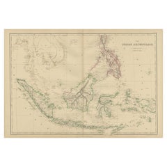
View AllAntique Map of the East Indies by Van der Aa '1849'
Located in Langweer, NL
Antique map titled 'Kaart van Nederlands OostIndie door A.J. van der Aa'. Old map of the Dutch East Indies. This map originates from 'Nederlands Oost-Indië, of beschrijving der Neder...
Category
Antique Mid-19th Century Maps
Materials
Paper

$383 Sale Price
20% Off
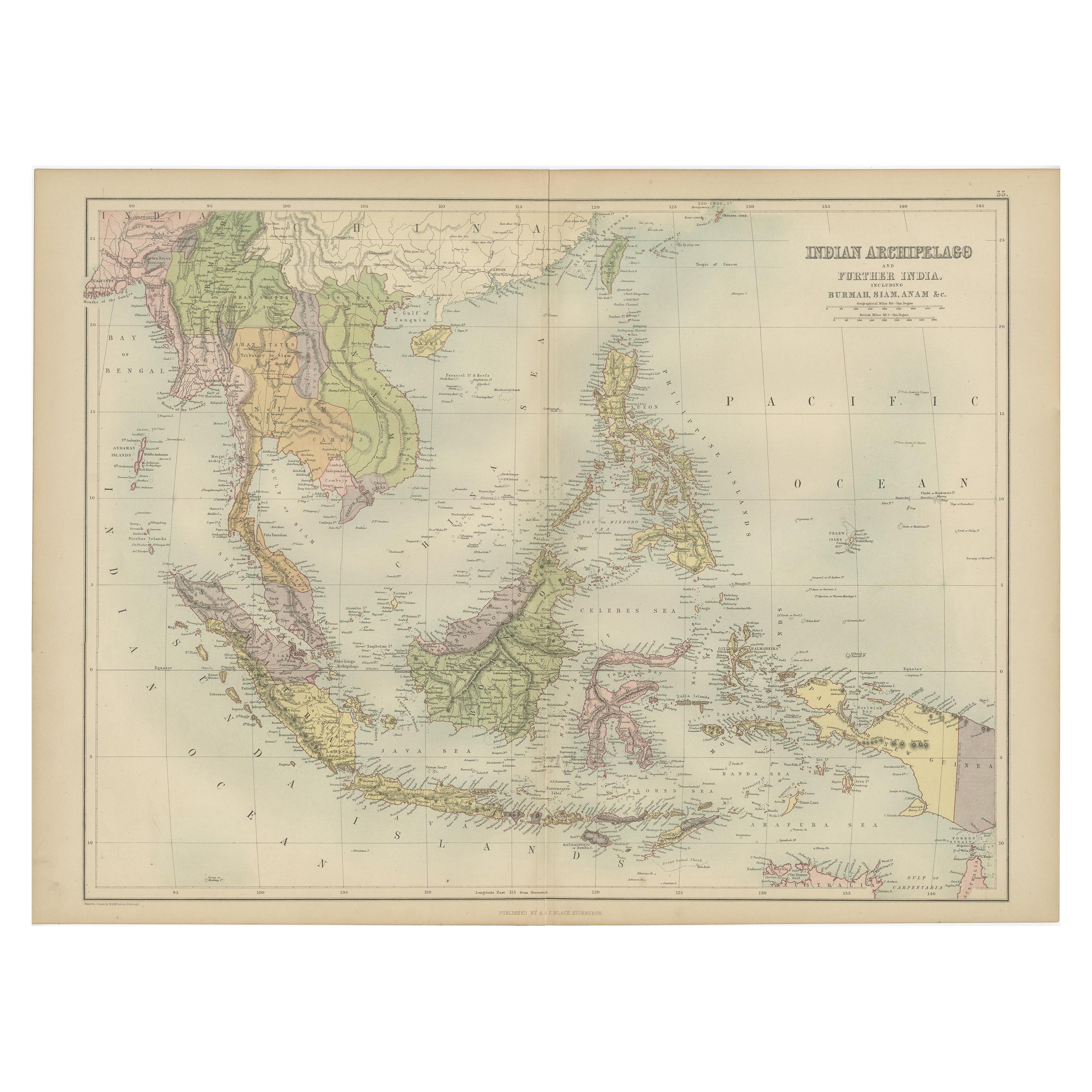
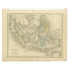
Antique Map of the East Indies by A & C. Black, 1870
Located in Langweer, NL
Antique map titled 'Indian Archipelago and Further India including Burmah, Siam, Anam &c'. Original antique map of Indian Archipelago and Further India. This map originates from ‘Bla...
Category
Antique Late 19th Century Maps
Materials
Paper
$263 Sale Price
20% Off
Antique Map of the East Indies by Levasseur, '1875'
Located in Langweer, NL
Antique map titled 'Carte de la Malaisie'. Large map of the East Indies. This map originates from 'Atlas de Géographie Moderne Physique et Politique' by A. Levasseur. Published 1875.
Category
Antique Late 19th Century Maps
Materials
Paper

$449 Sale Price
25% Off
Antique Map of the East Indies by Wyld '1845'
Located in Langweer, NL
Antique map titled 'Archipelago of the Indian Ocean'. Original antique map of the East Indies. This map originates from 'An Atlas of the World, Comprehending Separate Maps of its Var...
Category
Antique Mid-19th Century Maps
Materials
Paper

$335 Sale Price
20% Off
Antique Map of the East Indies by W. G. Blackie, 1859
Located in Langweer, NL
Antique map titled 'The Indian Archipelago'. Original antique map of the East Indies. This map originates from ‘The Imperial Atlas of Modern Geography’. Published by W. G. Blackie, 1...
Category
Antique Mid-19th Century Maps
Materials
Paper
$263 Sale Price
20% Off
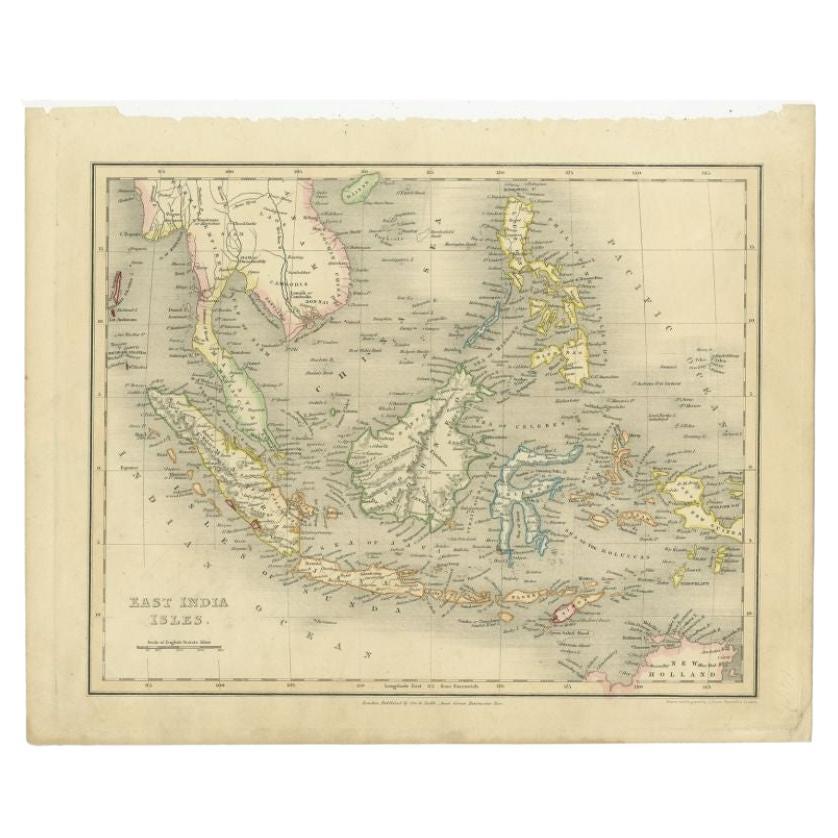
Antique Map of the East Indies by Dower, 1832
Located in Langweer, NL
Antique map titled 'East India Isles'. Old map of the East Indies. This map originates from 'A General Descriptive Atlas Of The Earth (..)' by J. Dower.
Artists and Engravers: Dr...
Category
Antique 19th Century Maps
Materials
Paper
$158 Sale Price
20% Off
You May Also Like
Large Original Antique Map of The West Indies by Sidney Hall, 1847
Located in St Annes, Lancashire
Great map of The West Indies
Drawn and engraved by Sidney Hall
Steel engraving
Original colour outline
Published by A & C Black. 1847
Unframed
Free shipping.
Category
Antique 1840s Scottish Maps
Materials
Paper

Large Original Antique Map of The Bahamas. 1894
Located in St Annes, Lancashire
Superb Antique map of The Bahamas
Published Edward Stanford, Charing Cross, London 1894
Original colour
Good condition
Unframed.
Free shipping
Category
Antique 1890s English Maps
Materials
Paper

Large Original Antique Map of The Leeward Islands. 1894
Located in St Annes, Lancashire
Superb Antique map of The Leeward Islands
Published Edward Stanford, Charing Cross, London 1894
Original colour
Good condition
Unframed.
Free shipping
Category
Antique 1890s English Maps
Materials
Paper

Original Antique Map of South East Asia by Thomas Clerk, 1817
Located in St Annes, Lancashire
Great map of South East Asia
Copper-plate engraving
Drawn and engraved by Thomas Clerk, Edinburgh.
Published by Mackenzie And Dent, 1817
Unframed.
Category
Antique 1810s English Maps
Materials
Paper

Large Original Antique Map of Java and Borneo, Fullarton, C.1870
Located in St Annes, Lancashire
Great map of Java and Borneo
Wonderful figurative borders
From the celebrated Royal Illustrated Atlas
Lithograph. Original color.
Published by Fullarton, Edinburgh. C.1870
Unfr...
Category
Antique 1870s Scottish Maps
Materials
Paper

Large Original Antique Map of The Canary Islands. 1894
Located in St Annes, Lancashire
Superb Antique map of The Canary Islands
Published Edward Stanford, Charing Cross, London 1894
Original colour
Good condition
Unframed.
Free shipping
Category
Antique 1890s English Maps
Materials
Paper

More Ways To Browse
The Vintage Map
West Indies Furniture
French School Map
Nova Scotia Antique Furniture
Richard Wentworth
Antique Mace
Map Of Madagascar
Map Of Normandy
Bali Map
Croatia Map
Gibraltar Antique Map
Albania Antique Map
Antique Furniture Kingston
Antique Louisiana Map
Armenia Map
L Tardieu
Chinese Wall Pocket
18th Century Nautical Engraving