Items Similar to Antique Map of India & Southeast Asia – Chevalier Engraving, Malte-Brun, 1853


Want more images or videos?
Request additional images or videos from the seller
1 of 13
Antique Map of India & Southeast Asia – Chevalier Engraving, Malte-Brun, 1853
$1,047.01
£783.69
€880
CA$1,438.10
A$1,607.97
CHF 843.45
MX$19,476.33
NOK 10,646.84
SEK 10,058.69
DKK 6,699.69
About the Item
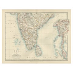
Antique Map of India and Southeast Asia – Chevalier Engraving from Malte-Brun’s Atlas, 1853
This beautifully engraved map titled “Inde, comprenant les Empires de la Chine, de l’Indoustan et de l’Indo-Chine” was published in 1853 by A.H. Dufour and drawn by Charles V. Monin. It was engraved by Ch. Dyonnet and printed by Chassant et Comp. for the renowned Atlas Universel de Géographie edited by Conrad Malte-Brun, a foundational figure in 19th-century French geography.
The map offers a comprehensive geographic view of the Indian subcontinent and Southeast Asia as they were understood in the mid-19th century. It stretches from Persia and Afghanistan in the west across India and Sri Lanka, through Burma and Siam (Thailand), all the way to Vietnam, Malaysia, southern China, and the northern part of the Philippines. Clearly labeled are British India’s major administrative divisions, princely states, and key cities such as Calcutta, Bombay, Madras, Delhi, Rangoon, and Bangkok. Also notable are the dense networks of roads, rivers, and mountain ranges carefully delineated in fine line engraving.
This map uses color coding to differentiate political boundaries and includes a legend identifying British possessions, independent kingdoms, tributary states, and trading centers. The Gulf of Bengal and the Bay of Bengal are clearly marked, along with maritime routes and topographic shading across the Himalayas and other mountainous regions.
The map was published at a time of major geopolitical developments in Asia, with European colonial powers expanding their influence across India and Southeast Asia. Its precision and clarity reflect the cartographic standards of French scientific publishing in the mid-19th century.
Condition: Very good overall. Clean, strong impression with original hand coloring. Slight toning, especially along the vertical centerfold (as issued). No tears or repairs. Wide margins and bright, stable paper.
Framing tips: Best displayed in a neoclassical or giltwood frame with a pale mat—cream or light grey—bringing out the subtle tones and delicate detail. Suitable for colonial history or exploration-themed decor.
Technique: Engraving with original hand color
Maker: Ch. Dyonnet after Monin, Paris, 1853
- Dimensions:Height: 33.23 in (84.4 cm)Width: 23.35 in (59.3 cm)Depth: 0.01 in (0.2 mm)
- Materials and Techniques:Paper,Engraved
- Place of Origin:
- Period:
- Date of Manufacture:circa 1853
- Condition:Condition: Very good overall. Clean, strong impression with original hand coloring. Slight toning, especially along the vertical centerfold (as issued). No tears or repairs. Wide margins and bright, stable paper.
- Seller Location:Langweer, NL
- Reference Number:Seller: BG-13776-21stDibs: LU3054346159302
About the Seller
5.0
Recognized Seller
These prestigious sellers are industry leaders and represent the highest echelon for item quality and design.
Platinum Seller
Premium sellers with a 4.7+ rating and 24-hour response times
Established in 2009
1stDibs seller since 2017
2,565 sales on 1stDibs
Typical response time: <1 hour
- ShippingRetrieving quote...Shipping from: Langweer, Netherlands
- Return Policy
Authenticity Guarantee
In the unlikely event there’s an issue with an item’s authenticity, contact us within 1 year for a full refund. DetailsMoney-Back Guarantee
If your item is not as described, is damaged in transit, or does not arrive, contact us within 7 days for a full refund. Details24-Hour Cancellation
You have a 24-hour grace period in which to reconsider your purchase, with no questions asked.Vetted Professional Sellers
Our world-class sellers must adhere to strict standards for service and quality, maintaining the integrity of our listings.Price-Match Guarantee
If you find that a seller listed the same item for a lower price elsewhere, we’ll match it.Trusted Global Delivery
Our best-in-class carrier network provides specialized shipping options worldwide, including custom delivery.More From This Seller
View AllAntique Map of India and Southeast Asia by Balbi '1847'
Located in Langweer, NL
Antique map titled 'India en deçà et au delà du Gange'. Original antique map of India and Souteast Asia. This map originates from 'Abrégé de Géographie (..)' by Adrien Balbi. Publish...
Category
Antique Mid-19th Century Maps
Materials
Paper

$142 Sale Price
20% Off
Antique Map of India and Ceylon by Lapie, 1842
Located in Langweer, NL
Antique map titled 'Carte de l'Inde en deca et au dela du Gange'. Map of India and Ceylon (Sri Lanka). This map originates from 'Atlas universel de géographie ancienne et moderne (.....
Category
Antique Mid-19th Century Maps
Materials
Paper

$523 Sale Price
20% Off
Antique Map of Southern India and South Eastern Provinces, 1903
Located in Langweer, NL
Title: Antique Map of Southern India and South Eastern Provinces, 1903, with Intricate Detail
Description:
This antique map, titled "India (Southern Sheet) and the South Eastern Pro...
Category
Early 20th Century Maps
Materials
Paper
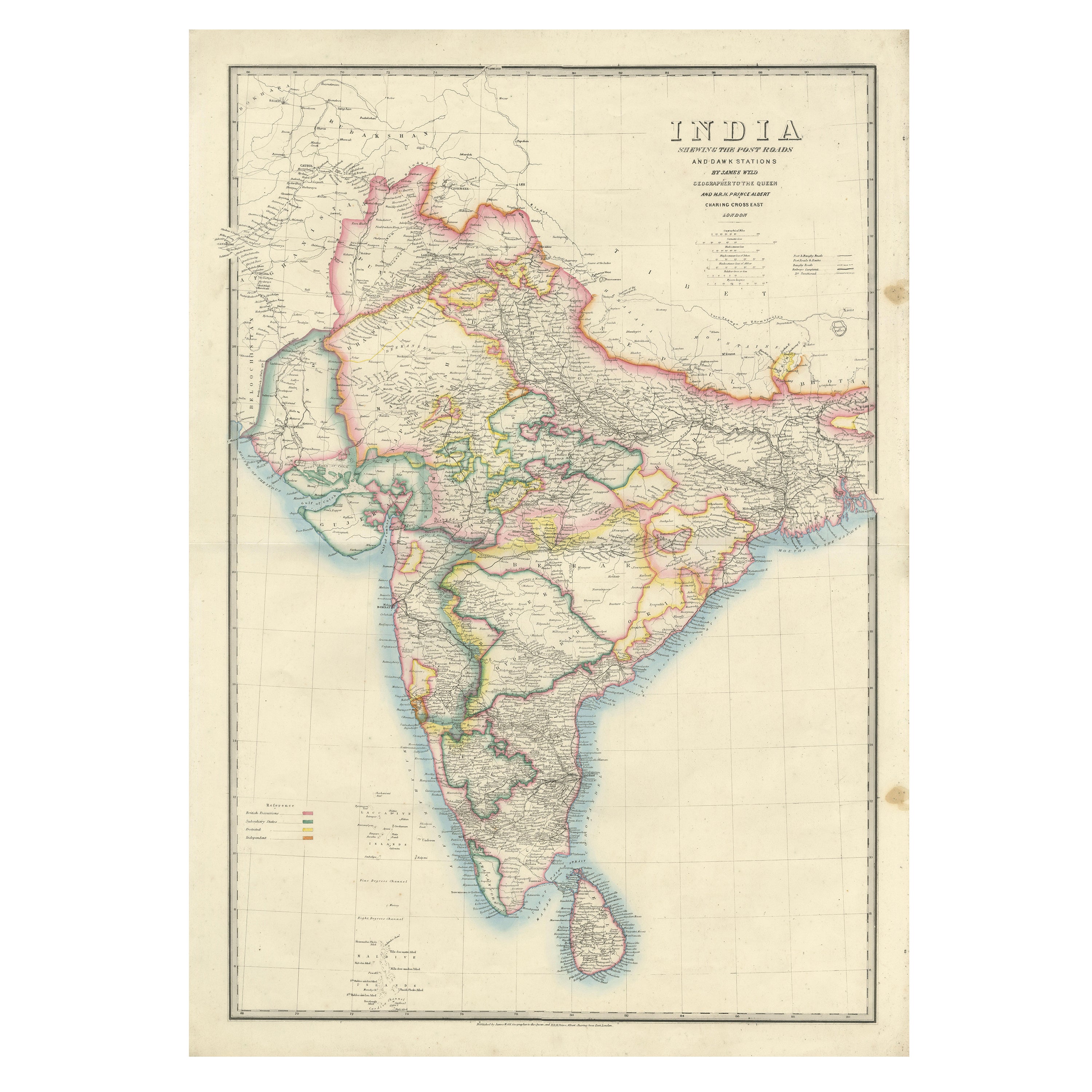
Large Antique Map of India – Post Roads and Dak Stations by James Wyld, c.1855
Located in Langweer, NL
Antique Map of India – Post Roads and Dak Stations by James Wyld, c.1855
This impressive antique map titled "India Shewing the Post Roads and Dak Stations" was engraved and publishe...
Category
Antique Mid-19th Century English Maps
Materials
Paper
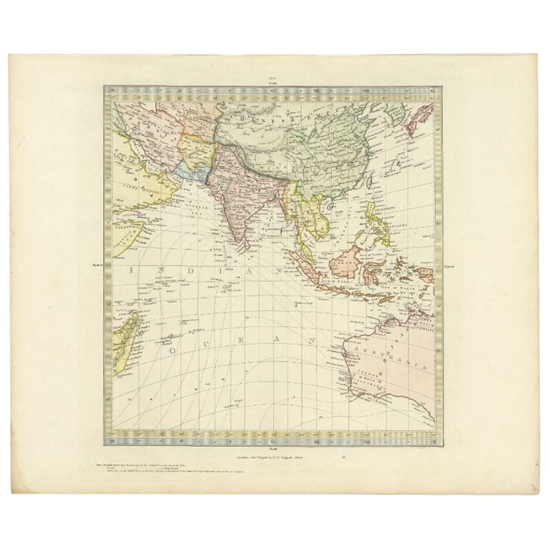
Antique Map of Southern Asia by Walker, c.1840
Located in Langweer, NL
"Original antique map of Southern Asia, the East Indies and the Indian Ocean. Also shows part of Australia. Published circa 1840. Artists and Engravers: ...
Category
Antique 19th Century Maps
Materials
Paper

$99 Sale Price
20% Off
Antique Map of Asia by Young, c.1860
Located in Langweer, NL
Antique map titled 'Asia'. Steel engraved map of Asia by Francis Young.
Artists and Engravers: Engraved by Lewis Becker. Published by S.O. Beeton.
We sell original antique maps to...
Category
Antique 19th Century Maps
Materials
Paper

$128 Sale Price
20% Off
You May Also Like
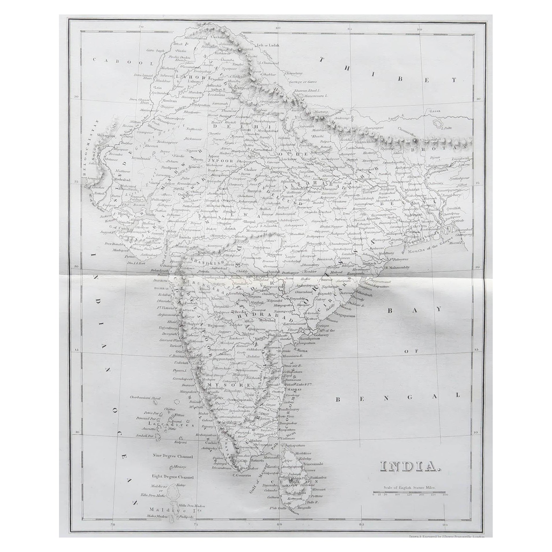
Original Antique Map of India by Dower, circa 1835
Located in St Annes, Lancashire
Nice map of India
Drawn and engraved by J.Dower
Published by Orr & Smith. C.1835
Unframed.
Free shipping
Category
Antique 1830s English Maps
Materials
Paper

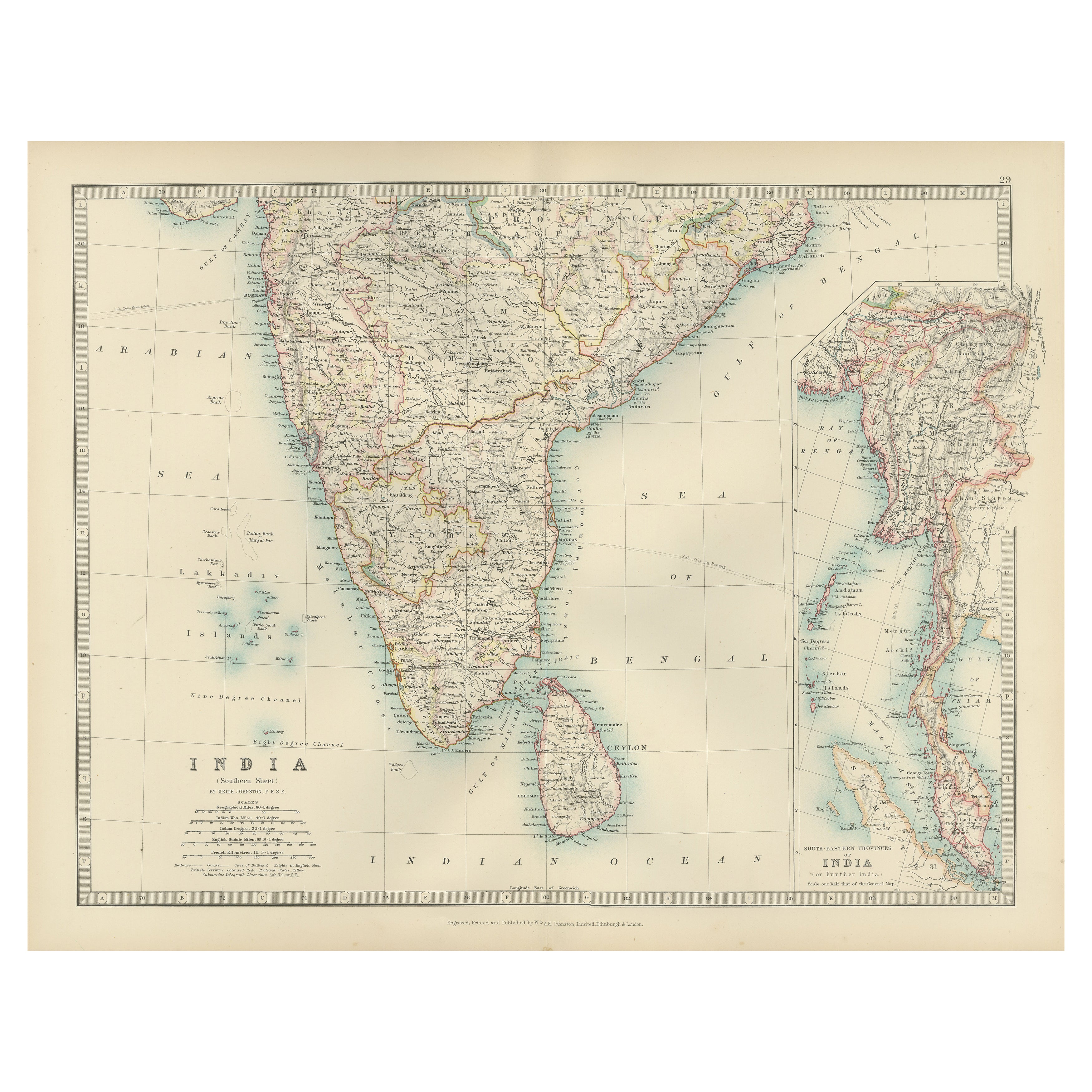
India (Southern Sheet), English antique map by Alexander Keith Johnston, 1901
Located in Melbourne, Victoria
'India (Southern Sheet)', antique lithographic map by Keith Johnston.
Inset maps of 'Bombay Island & Town', 'Madras & Environs', and 'South-Eastern Provinces of India'.
Central vertical fold as issued.
495mm by 625mm (sheet)
Alexander Keith...
Category
Early 20th Century Victorian More Prints
Materials
Lithograph

Antique 1803 Italian Map of Asia Including China Indoneseia India
Located in Amsterdam, Noord Holland
Antique 1803 Italian Map of Asia Including China Indoneseia India
Very nice map of Asia. 1803.
Additional information:
Type: Map
Country of Manufacturing: Europe
Period: 19th centu...
Category
Antique 19th Century European Maps
Materials
Paper

$584 Sale Price
20% Off
Original Antique Map of The Eastern Hemisphere by Dower, circa 1835
Located in St Annes, Lancashire
Nice map of the Eastern Hemisphere
Drawn and engraved by J.Dower
Published by Orr & Smith. C.1835
Unframed.
Free shipping
Category
Antique 1830s English Maps
Materials
Paper

Large Original Antique Map of Asia by Sidney Hall, 1847
Located in St Annes, Lancashire
Great map of Asia
Drawn and engraved by Sidney Hall
Steel engraving
Original colour outline
Published by A & C Black. 1847
Unframed
Free shipping
Category
Antique 1840s Scottish Maps
Materials
Paper

Large Original Vintage Map of India, circa 1920
Located in St Annes, Lancashire
Great map of India
Original color.
Good condition / repair to some minor damage just above Sri Lanka. Shown in the last image.
Published by Alexander Gross
Unframed.
Category
Vintage 1920s English Maps
Materials
Paper
