Items Similar to Antique Map of Italy – Pre-Unification Italy by Andriveau-Goujon, Paris 1861


Want more images or videos?
Request additional images or videos from the seller
1 of 10
Antique Map of Italy – Pre-Unification Italy by Andriveau-Goujon, Paris 1861
$463.83
£345.14
€390
CA$637.28
A$711.26
CHF 374.20
MX$8,639.81
NOK 4,743.89
SEK 4,439.69
DKK 2,968.92
About the Item
Antique Map of Italy – Pre-Unification Italy by Andriveau-Goujon, Paris 1861
This antique map of Italy, titled simply “Italie,” was published in Paris in 1861 by E. Andriveau-Goujon as plate no. 11 in his Atlas Universel. The map captures the Italian Peninsula and its surrounding islands just as Italy was undergoing unification, making it a compelling historical document of the fragmented political landscape that preceded the formation of the modern Italian state.
The map shows the entire Italian Peninsula, from the Alps in the north to the tip of Sicily in the south, including Corsica, Sardinia, Elba, and the coastal regions of Dalmatia and North Africa. It reflects the pre-unification borders, with the Italian states still divided among the Kingdom of Sardinia (including Piedmont and Sardinia), the Austrian-controlled Lombardy-Venetia in yellow, the Grand Duchy of Tuscany, the Papal States in central Italy, and the Kingdom of the Two Sicilies in the south. Each political entity is delicately shaded in pastel tones, offering a clear depiction of the regional divisions of the time.
Major cities such as Milan, Venice, Florence, Rome, Naples, Palermo, and Turin are clearly marked, alongside smaller towns, rivers, and transport routes. The Adriatic and Tyrrhenian coasts are well defined, and the surrounding Mediterranean context adds both geographic and visual interest.
This map was engraved and hand-colored with precision, featuring a decorative border and fine cartographic detail typical of Andriveau-Goujon's high-quality publications. Issued at a pivotal time in European history, it stands as both a beautiful piece of cartography and an important record of Italy before its unification was completed in the 1860s.
Condition: Very good condition. Slight toning around the edges and minimal foxing in the margins. Original centerfold as issued. Bright original coloring. Plate number “11” appears in the top right corner.
Framing tips: Best displayed in a classic black or gold frame with a light ivory or cream mat. A secondary inner mat in olive green or soft red can complement the tones of the Italian territories.
Technique: Engraving with original hand coloring
Maker: E. Andriveau-Goujon, Paris, 1861
- Dimensions:Height: 27.64 in (70.2 cm)Width: 20.91 in (53.1 cm)Depth: 0.01 in (0.2 mm)
- Materials and Techniques:Paper,Engraved
- Place of Origin:
- Period:
- Date of Manufacture:1861
- Condition:Condition: Very good condition. Slight toning around the edges and minimal foxing in the margins. Original centerfold as issued. Bright original coloring. Plate number “11” appears in the top right corner.
- Seller Location:Langweer, NL
- Reference Number:Seller: BG-14099-61stDibs: LU3054346185342
About the Seller
5.0
Recognized Seller
These prestigious sellers are industry leaders and represent the highest echelon for item quality and design.
Platinum Seller
Premium sellers with a 4.7+ rating and 24-hour response times
Established in 2009
1stDibs seller since 2017
2,567 sales on 1stDibs
Typical response time: <1 hour
- ShippingRetrieving quote...Shipping from: Langweer, Netherlands
- Return Policy
Authenticity Guarantee
In the unlikely event there’s an issue with an item’s authenticity, contact us within 1 year for a full refund. DetailsMoney-Back Guarantee
If your item is not as described, is damaged in transit, or does not arrive, contact us within 7 days for a full refund. Details24-Hour Cancellation
You have a 24-hour grace period in which to reconsider your purchase, with no questions asked.Vetted Professional Sellers
Our world-class sellers must adhere to strict standards for service and quality, maintaining the integrity of our listings.Price-Match Guarantee
If you find that a seller listed the same item for a lower price elsewhere, we’ll match it.Trusted Global Delivery
Our best-in-class carrier network provides specialized shipping options worldwide, including custom delivery.More From This Seller
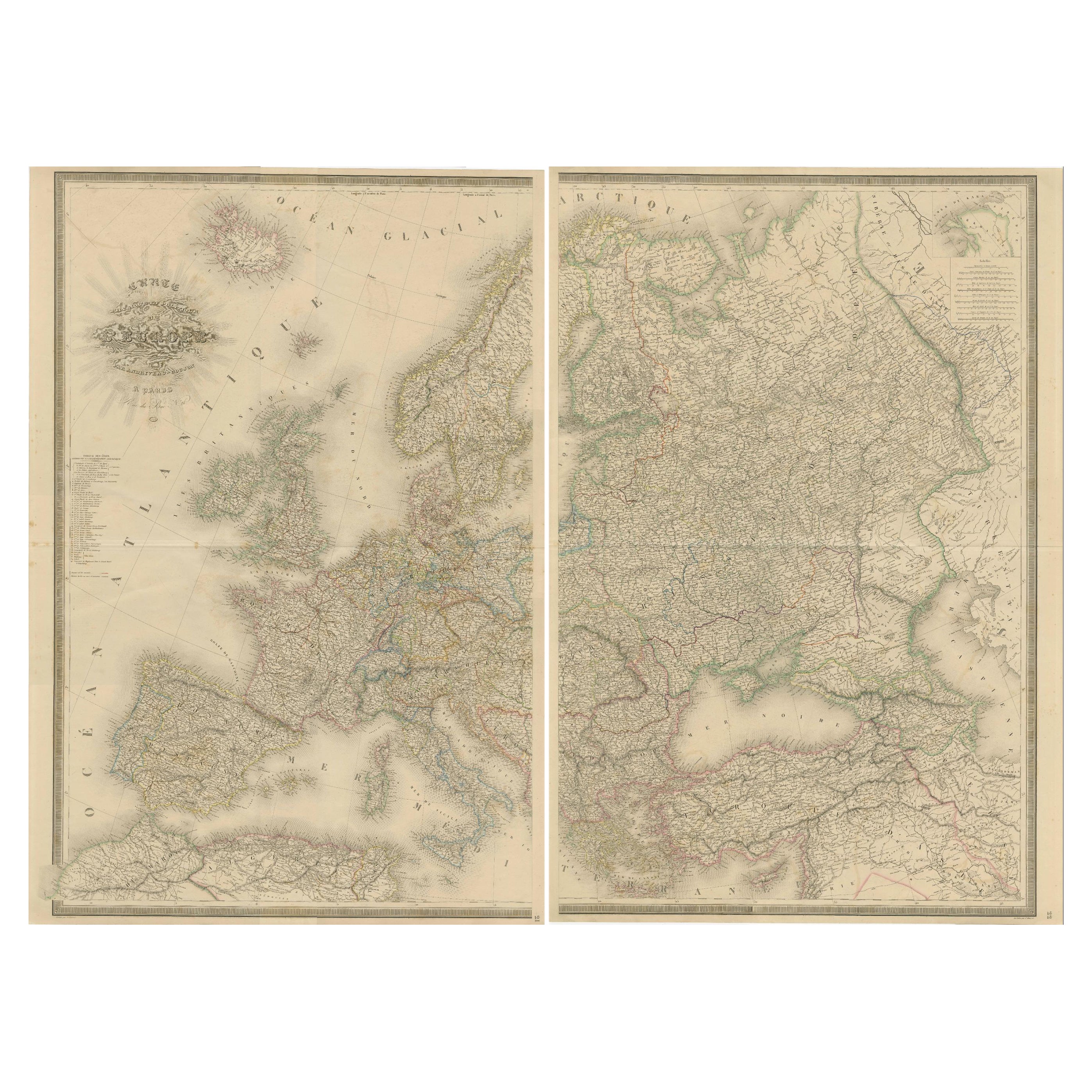
View AllMajestic Map of Europe by Andriveau-Goujon - Complete Continental View - ca.1849
Located in Langweer, NL
Majestic 19th Century Map of Europe by Andriveau-Goujon - Complete Continental View - Circa 1849
This magnificent and intricately detailed map of Europe, titled "Carte Physique et...
Category
Antique 1840s Maps
Materials
Paper
$732 Sale Price / set
20% Off
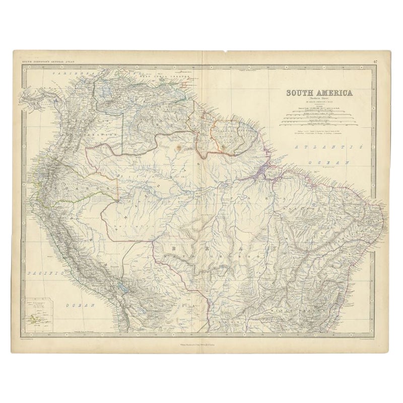
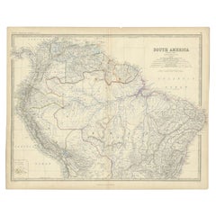
Antique Map of South America by Johnston, 1861
Located in Langweer, NL
Antique map titled 'South America'.
Old map of South America, with an inset map of the Galapagos Isles. This map originates from 'The Royal Atlas of Modern Geography, Exhibiting, i...
Category
Antique 19th Century Maps
Materials
Paper
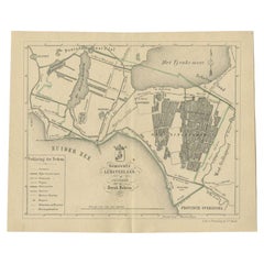
Antique Map of the Leeuwarderadeel Township by Behrns, 1861
Located in Langweer, NL
Antique map titled 'Gemeente Leeuwarderadeel'. Old map depicting the Leeuwarderadeel township including cities and villages like Finkum, Hijum, Stiens, Jelsum, Leeuwarden, Wirdum and...
Category
Antique 19th Century Maps
Materials
Paper

$84 Sale Price
20% Off
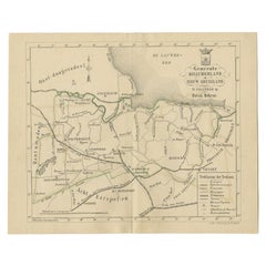
Antique Map of the Kollumerland Township by Behrns, 1861
Located in Langweer, NL
Antique map titled 'Gemeente Kollumerland en Nieuw Kruisland'. Old map depicting the Kollumerland township including cities and villages like Westergeest, Kollum, Kollumerzwaag and B...
Category
Antique 19th Century Maps
Materials
Paper
$84 Sale Price
20% Off
Antique Map of the Lemsterland Township by Behrns, 1861
Located in Langweer, NL
Antique map titled 'Gemeente Lemsterland'. Old map depicting the Lemsterland township including cities and villages like Lemmer, Follega, Oosterzee en Echten. This map orginates from...
Category
Antique 19th Century Maps
Materials
Paper
$84 Sale Price
20% Off
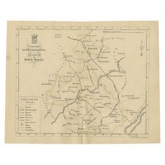
Antique Map of the Hennaarderadeel Township by Behrns, 1861
Located in Langweer, NL
Antique map titled 'Gemeente Hennaarderadeel'. Old map depicting the Hennaarderadeel township including cities and villages like Kubaard, Wommels, Hennaard, Oosterend, Wierum, Tzum, ...
Category
Antique 19th Century Maps
Materials
Paper
$84 Sale Price
20% Off
You May Also Like
Antique Map of Italy by Andriveau-Goujon, 1843
By Andriveau-Goujon
Located in New York, NY
Antique Map of Italy by Andriveau-Goujon, 1843. Map of Italy in two parts by Andriveau-Goujon for the Library of Prince Carini at Palazzo Carini i...
Category
Antique 1840s French Maps
Materials
Linen, Paper

$3,350 / set
Original Large Antique Map of Paris, France by John Dower, 1861
Located in St Annes, Lancashire
Fabulous monochrome map of Paris.
Vignettes of St Germain En Laye, Saint Cloud, Versailles and Fontainbleau.
Unframed.
Drawn by J.Dower.
Lithography by Weller. 4 sheets joined to...
Category
Antique 1860s English Victorian Maps
Materials
Paper

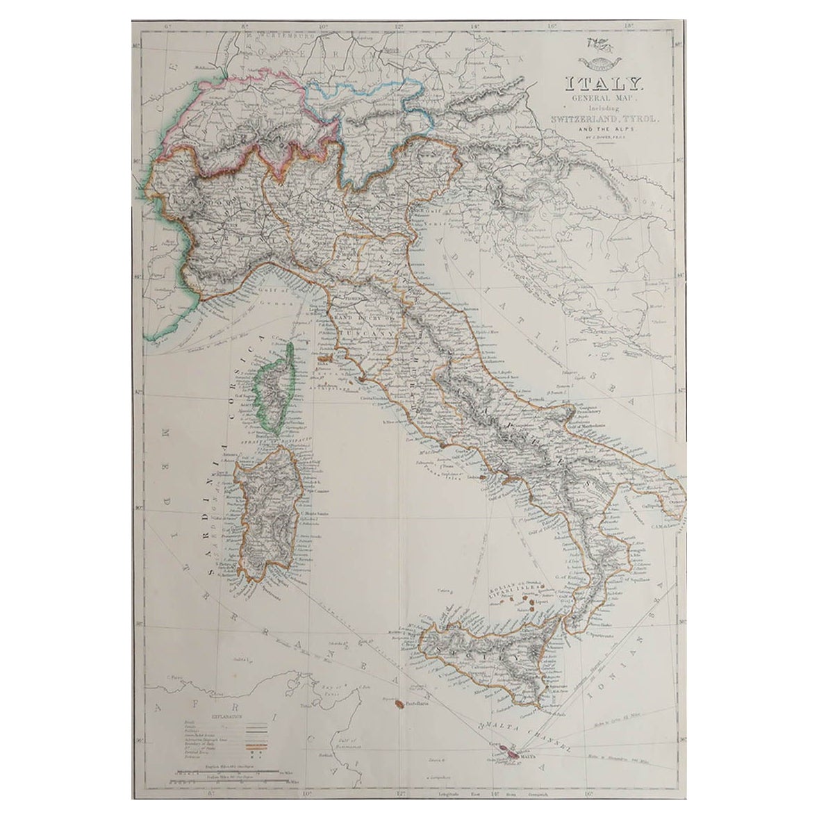
Large Original Antique Map of Italy. John Dower, 1861
Located in St Annes, Lancashire
Great map of Italy
Lithograph engraving by John Dower
Original colour
Published, 1861
Unframed
Good condition / repair to top right corner seen in last image
Category
Antique 1860s English Victorian Maps
Materials
Paper

Large Original Antique Map of The South of Italy. John Dower, 1861
Located in St Annes, Lancashire
Great map of the South of Italy
Lithograph engraving by John Dower
Original colour
Published, 1861
Unframed
Good condition
Free shipping
Category
Antique 1860s English Victorian Maps
Materials
Paper

Large Original Antique Map of Lombardy and Venice, Italy. John Dower, 1861
Located in St Annes, Lancashire
Great map of Lombardy and Venice
Lithograph engraving by John Dower
Original colour
Published, 1861
Unframed
Good condition / crease to bottom left corner
Free shipping
Category
Antique 1860s English Victorian Maps
Materials
Paper

Large Original Antique Map of Afghanistan. Edward Weller, 1861
Located in St Annes, Lancashire
Great map of Afghanistan
Lithograph engraving by Edward Weller
Original colour
Published, 1861
Unframed
Good condition
Category
Antique 1860s English Victorian Maps
Materials
Paper
