Items Similar to Antique Map of Piedmont, Savoy and Liguria by Justus Danckerts, Amsterdam c.1690


Want more images or videos?
Request additional images or videos from the seller
1 of 11
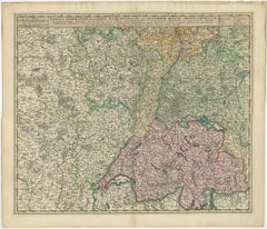
Antique Map of Piedmont, Savoy and Liguria by Justus Danckerts, Amsterdam c.1690
$1,019.30
£758.26
€850
CA$1,395.77
A$1,551.91
CHF 810.32
MX$18,890.52
NOK 10,339.35
SEK 9,687.48
DKK 6,470.58
Shipping
Retrieving quote...The 1stDibs Promise:
Authenticity Guarantee,
Money-Back Guarantee,
24-Hour Cancellation
About the Item
Map of Piedmont, Savoy and Liguria by Justus Danckerts, Amsterdam c.1690
This richly detailed and decorative map, titled *Tabula Generalis Ducatus Sabaudiae Principatus Pedemontii Comitatum Nicaeensis et Ducatus Montisferrati*, was published around 1690 by the Amsterdam cartographer Justus Danckerts (Iustinus Danckerus). He was one of the leading mapmakers in the Netherlands during the late 17th century, part of a family renowned for producing finely engraved and colored maps.
The map covers a large swath of Northern Italy and parts of southeastern France, focusing on the Duchy of Savoy, the Principality of Piedmont, the County of Nice, and the Ligurian coast, including Genoa. It reflects the strategic and political importance of these territories, especially during a time of shifting alliances and ongoing wars among European powers.
Danckerts’s map stands out for its clarity and precision, showing a dense network of cities, rivers, mountain ranges, and territorial boundaries. The Alps are rendered in expressive hachuring, and each region is outlined in hand-applied color. Prominent cities such as Turin, Nice, and Genoa are labeled, as well as key geographic features like Lake Geneva, the Po River, and the Mediterranean coast.
A beautifully ornate cartouche at the lower right features allegorical figures, coats of arms, and a dedication, highlighting the grandeur and authority of the map. The artistry and execution are typical of Dutch Golden Age cartography—both practical and decorative.
This map would have served as an important reference for military strategists, diplomats, and merchants operating in this politically significant region at the crossroads of France and Italy.
Condition summary:
Very good condition with original hand-color, central fold as issued, mild age toning. Strong impression but tight margins and some borders reinforced. A fine example of late 17th-century Dutch cartography.
Framing tips:
Best displayed in a dark wood or gold-leaf frame with a cream or soft beige mat to bring out the color contrast. Use UV-protective glass to preserve the hand-coloring and paper integrity over time.
- Dimensions:Height: 20.48 in (52 cm)Width: 23.86 in (60.6 cm)Depth: 0.01 in (0.2 mm)
- Materials and Techniques:Paper,Engraved
- Period:Late 17th Century
- Date of Manufacture:circa 1690
- Condition:Refinished. Very good condition with original hand-color, central fold as issued, mild age toning. Strong impression but tight margins and some borders reinforced. A fine example of late 17th-century Dutch cartography.
- Seller Location:Langweer, NL
- Reference Number:Seller: BG-13732-51stDibs: LU3054345364122
About the Seller
5.0
Recognized Seller
These prestigious sellers are industry leaders and represent the highest echelon for item quality and design.
Platinum Seller
Premium sellers with a 4.7+ rating and 24-hour response times
Established in 2009
1stDibs seller since 2017
2,511 sales on 1stDibs
Typical response time: <1 hour
- ShippingRetrieving quote...Shipping from: Langweer, Netherlands
- Return Policy
Authenticity Guarantee
In the unlikely event there’s an issue with an item’s authenticity, contact us within 1 year for a full refund. DetailsMoney-Back Guarantee
If your item is not as described, is damaged in transit, or does not arrive, contact us within 7 days for a full refund. Details24-Hour Cancellation
You have a 24-hour grace period in which to reconsider your purchase, with no questions asked.Vetted Professional Sellers
Our world-class sellers must adhere to strict standards for service and quality, maintaining the integrity of our listings.Price-Match Guarantee
If you find that a seller listed the same item for a lower price elsewhere, we’ll match it.Trusted Global Delivery
Our best-in-class carrier network provides specialized shipping options worldwide, including custom delivery.More From This Seller
View AllAntique Map of Northern Italy by F. de Wit, 1690
Located in Langweer, NL
A very decorative map centered on Genua, and including the towns of Milan, Torino, Parma, Cremona, etc. Decorative title cartouche upper right, five putti holding the arms of the reg...
Category
Antique Late 17th Century Maps
Materials
Paper

$527 Sale Price
20% Off
Antique Map of Switzerland by N. Visscher, circa 1690
Located in Langweer, NL
Antique map titled 'Tabula Geogaphica qua Pars Meridionalis sive Superior Rheni, Mosae, et Mosellae (..)'. Published by N. Visscher, Amsterdam, circa 1690. Contemporary coloring.
Category
Antique Late 17th Century Maps
Materials
Paper
$637 Sale Price
20% Off
Antique Map of Austria by F. de Wit, 1690
Located in Langweer, NL
Antique map titled 'Circuli Austriaci pars Septentrionalis in qua Archiducatus'. Decorative and detailed map of Austria by F. de Wit.
Category
Antique Late 17th Century Maps
Materials
Paper

Rare Hand-Colored Map of Lyonnais Region in France by Frederik De Wit c. 1688
Located in Langweer, NL
Title: Rare Hand-Colored Map of Lyonnais Region by Frederik De Wit c. 1688
Description: This beautifully detailed map, "Gouvernement General du Lyonnois," showcases the Lyonnais reg...
Category
Antique 1680s Maps
Materials
Paper

Decorative Original Antique Map of Southern Germany, c.1730
Located in Langweer, NL
"Antique map titled 'The South West Part of Germany. Containing ye Dominions of the Archbishops and Electors of Mentz Y Treves, and of ye Elec. Palatine of ye Rhine; with Franconia, ...
Category
Antique 18th Century Maps
Materials
Paper

Antique Map of Northern Italy by Homann Heirs, c.1730
Located in Langweer, NL
Antique map titled 'Domini Veneti cum vicinis Parmae Mutinae, Matuae et Mirandol (..).' Detailed map of northern Italy by J. B. Homann. This map shows Venice and its adjacent states ...
Category
Antique 18th Century Maps
Materials
Paper

$498 Sale Price
20% Off
You May Also Like
17th Century Hand Colored Map of the Liege Region in Belgium by Visscher
By Nicolaes Visscher II
Located in Alamo, CA
An original 17th century map entitled "Leodiensis Episcopatus in omnes Subjacentes Provincias distincté divisusVisscher, Leodiensis Episcopatus" by Nicolaes Visscher II, published in Amsterdam in 1688. The map is centered on Liege, Belgium, includes the area between Antwerp, Turnhout, Roermond, Cologne, Trier and Dinant.
This attractive map is presented in a cream-colored mat measuring 30" wide x 27.5" high. There is a central fold, as issued. There is minimal spotting in the upper margin and a tiny spot in the right lower margin, which are under the mat. The map is otherwise in excellent condition.
The Visscher family were one of the great cartographic families of the 17th century. Begun by Claes Jansz Visscher...
Category
Antique Late 17th Century Dutch Maps
Materials
Paper

1640 Willem Blaeu Map Entitled "Contado di molise et principato vltra, " Ric.a003
By Willem Blaeu
Located in Norton, MA
1640 Willem Blaeu map entitled
"Contado di molise et principato vltra,"
Colored
Ric. a003
Measures: 38 x 49.6 cm and wide margins
DBLAEU.
Cou...
Category
Antique 17th Century Dutch Maps
Materials
Paper

17th Century Hand-Colored Map of a Region in West Germany by Janssonius
By Johannes Janssonius
Located in Alamo, CA
This attractive highly detailed 17th century original hand-colored map is entitled "Archiepiscopatus Maghdeburgensis et Anhaltinus Ducatus cum terris adjacentibus". It was published ...
Category
Antique Mid-17th Century Dutch Maps
Materials
Paper

Original Antique Map of Switzerland, Engraved By Barlow, Dated 1807
Located in St Annes, Lancashire
Great map of Switzerland
Copper-plate engraving by Barlow
Published by Brightly & Kinnersly, Bungay, Suffolk.
Dated 1807
Unframed.
Category
Antique Early 1800s English Maps
Materials
Paper

18th Century Hand-Colored Homann Map of Germany, Including Frankfurt and Berlin
By Johann Baptist Homann
Located in Alamo, CA
An 18th century hand-colored map entitled "Tabula Marchionatus Brandenburgici et Ducatus Pomeraniae quae sunt Pars Septentrionalis Circuli Saxoniae Superioris" by Johann Baptist Homa...
Category
Antique Early 18th Century German Maps
Materials
Paper

18th Century Map of the Southern Balkans by Giovanni Maria Cassini
By Giovanni Maria Cassini
Located in Hamilton, Ontario
18th century map by Italian engraver Giovanni Maria Cassini (Italy 1745-1824).
Map of the Southern Balkans: Rome. Hand colored and copper engraved print done in the year 1788. It in...
Category
Antique 18th Century Italian Maps
Materials
Paper

$795 Sale Price
36% Off
More Ways To Browse
Foldable Military
Savoy Furniture
Piedmont Furniture
C Milder
17th C Italian Furniture
Dutch Military
17th Century Dutch Wood Frames
Styles Of Antique Desks
Black And White Coffee Table
Curved Velvet Couch
Velvet Curved Sofa
Wood Round Coffee Tables
Antique Paper Flowers
Oak Brutalist
Used College Furniture
Wood Minimalist Chair
2002 Lamp
Antique Imperial Furniture