Items Similar to Antique Map of the Ryukyu Islands – Map of the Islands of Lieou-Kieou, c.1760


Want more images or videos?
Request additional images or videos from the seller
1 of 10
Antique Map of the Ryukyu Islands – Map of the Islands of Lieou-Kieou, c.1760
$548.20
£405.98
€460
CA$755.26
A$839.72
CHF 442.16
MX$10,188.30
NOK 5,597.99
SEK 5,232.76
DKK 3,501.44
About the Item
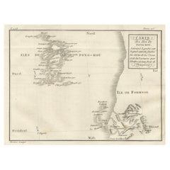
Map of the Ryukyu Islands – “Carte des Isles de Lieou-Kieou”, c.1760
This rare 18th-century copperplate map, titled Carte des Isles de Lieou-Kieou, presents the Ryukyu Islands (today Okinawa Prefecture, Japan) and surrounding waters, based on Chinese sources. Ishigaki Island should be on the map as well. The title notes that it was “Dreſsée sur les Mémoires Chinois, par le R.P. Gaubil de la Compagnie de Jésus, Missionnaire à Péking” — compiled from Chinese records by the Jesuit missionary Jean-Baptiste Joseph Gaubil during his time in Beijing.
The map covers the island chain stretching from the southern tip of Japan to Taiwan (Isle de Formose), with individual islands carefully named in French transliterations of Chinese forms. Among the labeled locations are the “Grande Isle de Lieou-Kieou” (Okinawa), “Port de Napakiang” (Naha), “Ile de Sooloo”, “Tanaxima” (Tanegashima), and “Kilongchan” on Formosa. Coastal features, settlements, and sailing routes are also marked, including the “Route de Kilongchan au Port de Napakiang.”
The engraving reflects the Jesuit role in transmitting East Asian geographic knowledge to Europe during the Enlightenment. By using Chinese cartographic sources, European mapmakers could depict regions that were otherwise little known in the West, especially given Japan’s policy of limited contact (sakoku) during the Edo period. The inclusion of Formosa and parts of Kyushu highlights the Ryukyu Kingdom’s strategic position between China, Japan, and Southeast Asia.
Marked “Tome 12” in the upper right, the map was part of a larger multi-volume travel and exploration series. The neatline features a dual scale in both French leagues and Chinese li, underscoring its cross-cultural origin.
Collectors of Japanese and East Asian cartography, as well as those interested in the history of Jesuit science, will appreciate this as a fine example of 18th-century geographic knowledge exchange.
Condition: Very good for age, with central folds as issued. Slight toning and light handling marks in the margins. Crisp plate impression with clear lettering.
Framing tips: A black or dark walnut frame with a soft ivory mount will enhance the clean lines and subtle shading of the engraving. For thematic effect, it can be displayed alongside other 18th-century maps of Japan, Taiwan, and China.
Technique: Copperplate engraving
Maker: Jean-Baptiste Joseph Gaubil (source), French school, c.1760
- Dimensions:Height: 7.88 in (20 cm)Width: 10.08 in (25.6 cm)Depth: 0.01 in (0.2 mm)
- Materials and Techniques:Paper,Engraved
- Place of Origin:
- Period:
- Date of Manufacture:circa 1760
- Condition:Condition: Very good for age, with central folds as issued. Slight toning and light handling marks in the margins. Crisp plate impression with clear lettering.
- Seller Location:Langweer, NL
- Reference Number:Seller: BG-14078-271stDibs: LU3054346217612
About the Seller
5.0
Recognized Seller
These prestigious sellers are industry leaders and represent the highest echelon for item quality and design.
Platinum Seller
Premium sellers with a 4.7+ rating and 24-hour response times
Established in 2009
1stDibs seller since 2017
2,569 sales on 1stDibs
Typical response time: <1 hour
- ShippingRetrieving quote...Shipping from: Langweer, Netherlands
- Return Policy
Authenticity Guarantee
In the unlikely event there’s an issue with an item’s authenticity, contact us within 1 year for a full refund. DetailsMoney-Back Guarantee
If your item is not as described, is damaged in transit, or does not arrive, contact us within 7 days for a full refund. Details24-Hour Cancellation
You have a 24-hour grace period in which to reconsider your purchase, with no questions asked.Vetted Professional Sellers
Our world-class sellers must adhere to strict standards for service and quality, maintaining the integrity of our listings.Price-Match Guarantee
If you find that a seller listed the same item for a lower price elsewhere, we’ll match it.Trusted Global Delivery
Our best-in-class carrier network provides specialized shipping options worldwide, including custom delivery.More From This Seller
View All1758 Bellin Map of Guadeloupe and Marie-Galante – Caribbean Islands
Located in Langweer, NL
Thank you for noting the correct date on the map. Here is your **updated plain text catalog listing**:
---
**Title (under 80 characters):**
1758 Bellin Map of Guadeloupe and Marie-Galante – Caribbean Islands
**Description:**
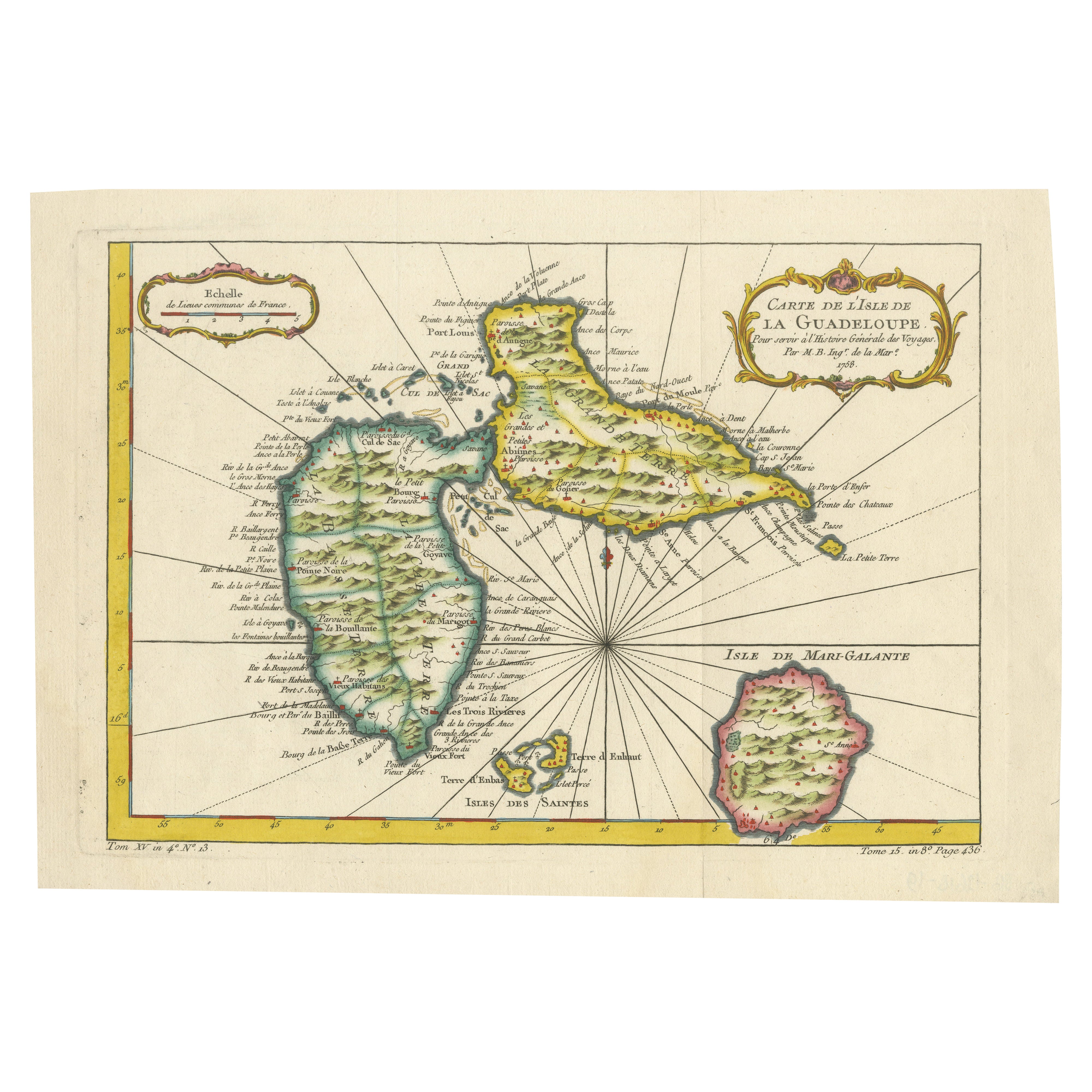
Original antique map titled *Carte de l’Isle de la Guadeloupe* by Jacques Nicolas Bellin, engraved for the *Histoire Générale des Voyages*, published in Paris in 1758.
This finely engraved copperplate map depicts the French Caribbean island of Guadeloupe, showing its distinctive butterfly-shaped division into Basse-Terre and Grande-Terre. The surrounding smaller islands include Marie-Galante (bottom right) and Les Saintes. The map details numerous place names, parishes, rivers, bays, mountains, and anchorages. A decorative rococo title cartouche graces the upper right corner, complemented by a scale bar cartouche in the upper left.
Jacques Nicolas Bellin (1703-1772) served as Hydrographer to the King and was one of the most prominent French cartographers of the 18th century, producing maps noted for their accuracy, elegance, and clarity. This map was created for the influential *Histoire Générale des Voyages* by Abbé Prévost.
Condition report:
Excellent condition. Strong and clean impression on fine laid paper with wide margins. Original hand coloring in outline and wash, highlighting coastlines and cartouches. Minor age toning at edges; verso blank.
Framing suggestion:
Frame with a classic gold or dark wood moulding and a neutral cream archival mat to emphasize the fine engraving and delicate color washes. Museum glass is recommended to preserve this 18th-century Caribbean map...
Category
Antique Mid-18th Century French Maps
Materials
Paper

Martinique Map by Rigobert Bonne – French Antique Map, c.1768
Located in Langweer, NL
Map of Martinique by Rigobert Bonne, circa 1768
This is a detailed antique map of Martinique titled “Isle de la Martinique,” engraved by Rigobert Bonne around 1768 for the Atlas Encyclopédique. Bonne, a renowned French hydrographer and successor to Bellin, is celebrated for his scientifically precise and elegantly engraved maps.
The map shows Martinique with its mountainous interior, rivers, and settlements labelled, including Fort Royal, Fort St. Pierre, Le Marin, and Le Prêcheur. Coastal features, bays, and capes are marked, along with anchorages important for maritime navigation in the 18th century. The depiction includes relief shown pictorially, characteristic of Bonne’s cartographic style, enhancing both geographic understanding and aesthetic appeal.
This copperplate engraving retains original hand colouring outlining the coastlines in delicate blue and brown tones, typical for the period. It served as a key reference for scholars, navigators, and colonial administrators during France’s colonial presence in the Caribbean.
Condition:
Good condition overall. A strong impression with bright, original hand-colour outlines. General age toning, faint offsetting, and a vertical fold as issued in the atlas. Margins ample all around for framing.
Framing suggestions:
This historic Caribbean map...
Category
Antique 1760s French Maps
Materials
Paper

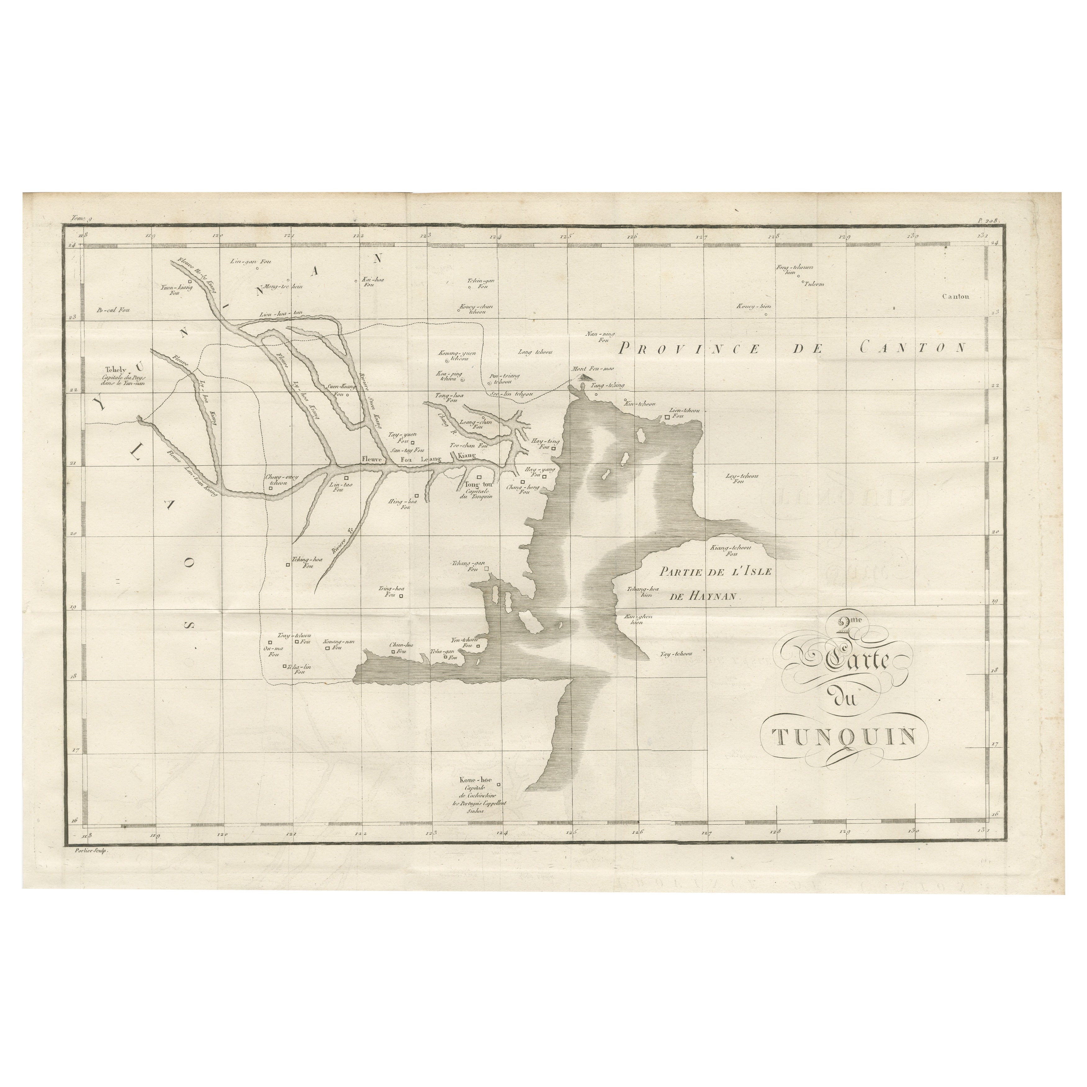
Map of Pescadores Islands (Pong-Hou) & Formosa – French Jesuit Engraving, 1790
Located in Langweer, NL
Map of the Pescadores Islands (Pong-Hou) and Formosa – French Jesuit Engraving by Portier, c.1790
This finely engraved French map, produced by Portier around 1790, depicts the Pesca...
Category
Antique Late 18th Century French Maps
Materials
Paper
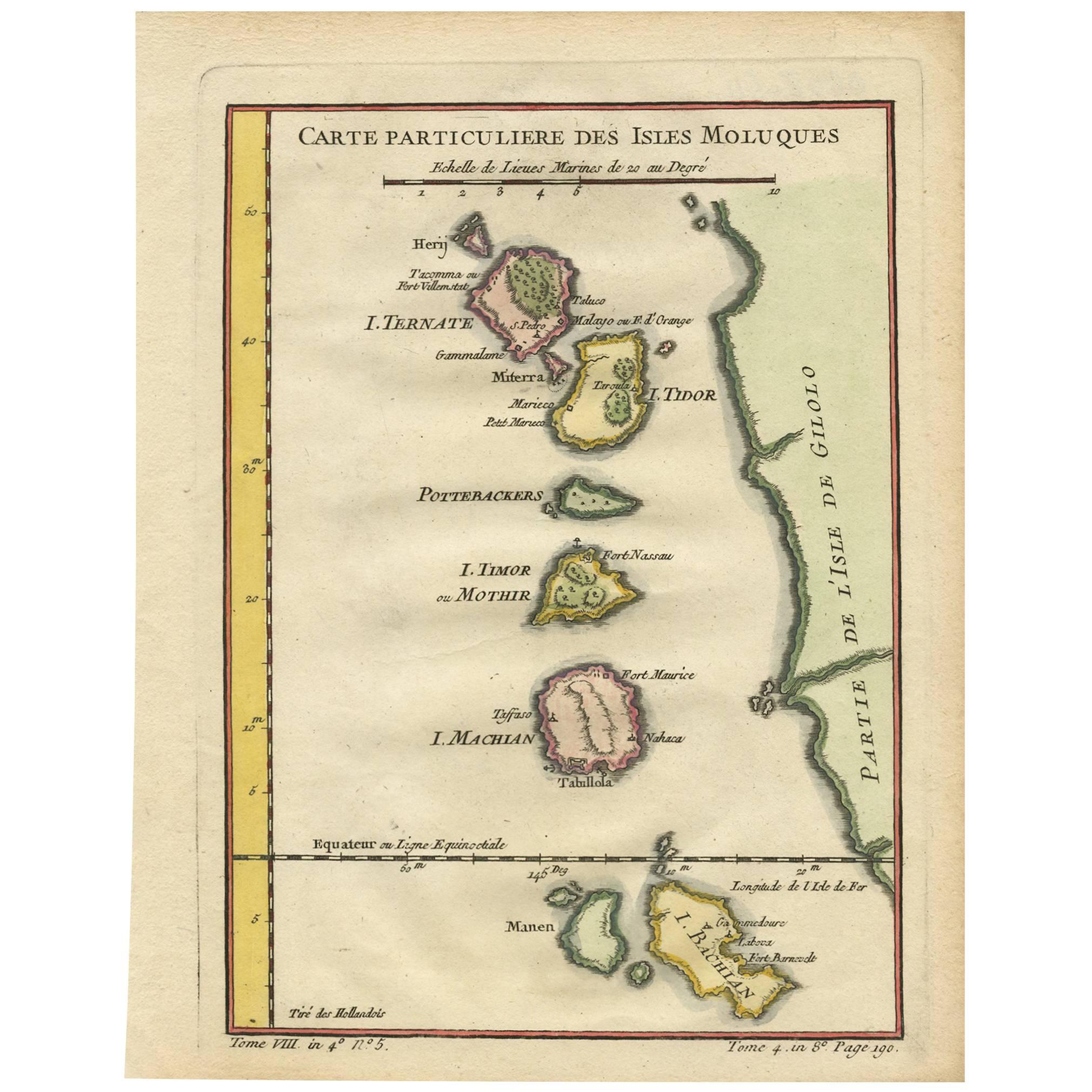
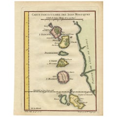
Antique Map of the Maluku Islands by Bellin, c.1750
By Jacques-Nicolas Bellin
Located in Langweer, NL
Antique map titled 'Carte Particuliere des Isles Moluques'. This map depicts the islands of Herij, Ternate, Tidor, Pottebackers, Timor, Machian and Bachian. The Moluccan islands were...
Category
Antique 18th Century Maps
Materials
Paper

$119 Sale Price
20% Off
Antique Map of the Moluques Islands, Part of Indonesia, circa 1750
Located in Langweer, NL
Map of the Moluques (also known as the Moluccas, Moluccan Islands or simply Maluku). Depicts the islands of Herij, Ternate, Tidor, Pottebackers, Timor, Machian and Bachian.
Category
Antique Mid-18th Century Maps
Materials
Paper
$200 Sale Price
20% Off
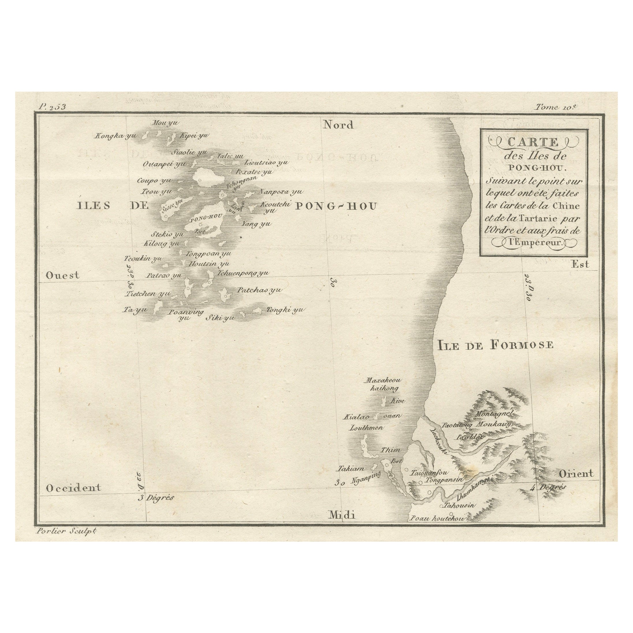
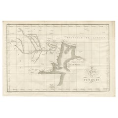
Antique Map of Tonkin and Hainan Island – 18th Century French Engraving
Located in Langweer, NL
Antique Map of Tonkin and Hainan Island – 18th Century French Engraving
This is the “5me Carte du Tunquin,” an antique engraved map depicting the northern coastal region of modern-d...
Category
Antique Late 18th Century French Maps
Materials
Paper
You May Also Like
Antique French Map of Asia Including China Indoneseia India, 1783
Located in Amsterdam, Noord Holland
Very nice map of Asia. 1783 Dedie au Roy.
Additional information:
Country of Manufacturing: Europe
Period: 18th century Qing (1661 - 1912)
Condition: Overall Condition B (Good Used)...
Category
Antique 18th Century European Maps
Materials
Paper

$648 Sale Price
20% Off
St. Christophe (St. Kitts): Bellin 18th Century Hand Colored Map
Located in Alamo, CA
Jacques Bellin's copper-plate map of the Caribbean island of Saint Kitts entitled "Carte De De l'Isle St. Christophe Pour servir á l'Histoire Genle. des V...
Category
1740s Other Art Style Landscape Prints
Materials
Engraving

Map Of Martinique - Etching - 19th Century
Located in Roma, IT
Map Of Martinique is an etching realized by an anonymous engraver of the 19th Century.
Printed within the series "France Pittoresque" at the top center.
The state of preservation o...
Category
19th Century Modern Figurative Prints
Materials
Etching

Antique Map - Mare Pacificum - Etching by Johannes Janssonius - 1650s
By Johannes Janssonius
Located in Roma, IT
Mare Pacificum is an antique map realized in 1650 by Johannes Janssonius (1588-1664).
The Map is Hand-colored etching, with coeval watercolorang.
Good conditions with slight foxing...
Category
1650s Modern Figurative Prints
Materials
Etching

West Coast of Africa; Guinea & Sierra Leone: Bellin 18th Century Map
Located in Alamo, CA
This is a Jacques Bellin copper-plate map entitled "Partie de la Coste de Guinee Dupuis la Riviere de Sierra Leona Jusquau Cap das Palmas", depicting the coast of Guinea and Sierra L...
Category
1740s Old Masters Landscape Prints
Materials
Engraving

Ancient Map - Zeilan - Etching by Johannes Janssonius - 1650s
By Johannes Janssonius
Located in Roma, IT
Ancient Map - Zeilan is an ancient map realized in 1650 by Johannes Janssonius (1588-1664).
The Map is Hand-colored etching, with coeval watercoloring.
...
Category
1650s Modern Figurative Prints
Materials
Etching
