Items Similar to Batavia 1733 - Hand-Colored Antique Harbor Map of Nowadays Jakarta in Indonesia

Want more images or videos?
Request additional images or videos from the seller
1 of 6
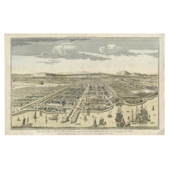
Batavia 1733 - Hand-Colored Antique Harbor Map of Nowadays Jakarta in Indonesia
On Hold
$555.15
On Hold
£417.11
On Hold
€470
On Hold
CA$764.45
On Hold
A$855.56
On Hold
CHF 447.86
On Hold
MX$10,393.50
On Hold
NOK 5,686.62
On Hold
SEK 5,366.30
On Hold
DKK 3,577.17
About the Item
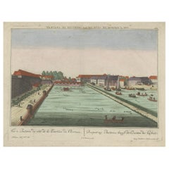
A historical print depicting the city of Batavia (present-day Jakarta during the Dutch colonial period). The view is from the sea, looking towards the city. The skyline is dominated by European-style buildings, indicative of colonial architecture, with a mountain range in the background. In the foreground, various sailing ships, representative of the 17th-century naval technology, dominate the harbor. Some are anchored, while others are under sail, with a few small boats scattered between them. The sea is rendered with careful lines to suggest waves, and the sky is filled with clouds, possibly suggesting a bustling port city with a dynamic maritime culture.
The text "Guiseppe Filosi Sculp. Vin." indicates the artist who engraved the print (Guiseppe Filosi) and may suggest a place associated with the artist or the creation of the print (possibly Venice, abbreviated as "Vin."). The presence of such text usually indicates the printmaker’s signature and is common in historical prints.
More research needed. Possibly published by Tirion on the early 18th century.
- Dimensions:Height: 7.09 in (18 cm)Width: 12.21 in (31 cm)Depth: 0 in (0.02 mm)
- Materials and Techniques:Paper,Engraved
- Period:1730-1739
- Date of Manufacture:1733
- Condition:Good. There are visible central vertical folds, which is common in old maps that were originally bound in books. Later hand-coloring. Tight margin on the top, but image is intact. Ideal for framing.
- Seller Location:Langweer, NL
- Reference Number:Seller: BG-13454-61stDibs: LU3054337747602
About the Seller
5.0
Recognized Seller
These prestigious sellers are industry leaders and represent the highest echelon for item quality and design.
Platinum Seller
Premium sellers with a 4.7+ rating and 24-hour response times
Established in 2009
1stDibs seller since 2017
2,534 sales on 1stDibs
Typical response time: <1 hour
- ShippingRetrieving quote...Shipping from: Langweer, Netherlands
- Return Policy
Authenticity Guarantee
In the unlikely event there’s an issue with an item’s authenticity, contact us within 1 year for a full refund. DetailsMoney-Back Guarantee
If your item is not as described, is damaged in transit, or does not arrive, contact us within 7 days for a full refund. Details24-Hour Cancellation
You have a 24-hour grace period in which to reconsider your purchase, with no questions asked.Vetted Professional Sellers
Our world-class sellers must adhere to strict standards for service and quality, maintaining the integrity of our listings.Price-Match Guarantee
If you find that a seller listed the same item for a lower price elsewhere, we’ll match it.Trusted Global Delivery
Our best-in-class carrier network provides specialized shipping options worldwide, including custom delivery.More From This Seller
View AllAntique Map of Batavia, Nowadays Jakarta, the Capital of Indonesia, 1782
Located in Langweer, NL
Antique map Batavia titled 'Batavia zo als het was in den Jaare 1731'. Old map of the city of Batavia (Jakarta) in Indonesia. Originates from 'Batavia, de Hoofdstad van Neerlands O. ...
Category
Antique 18th Century Maps
Materials
Paper
$897 Sale Price
20% Off
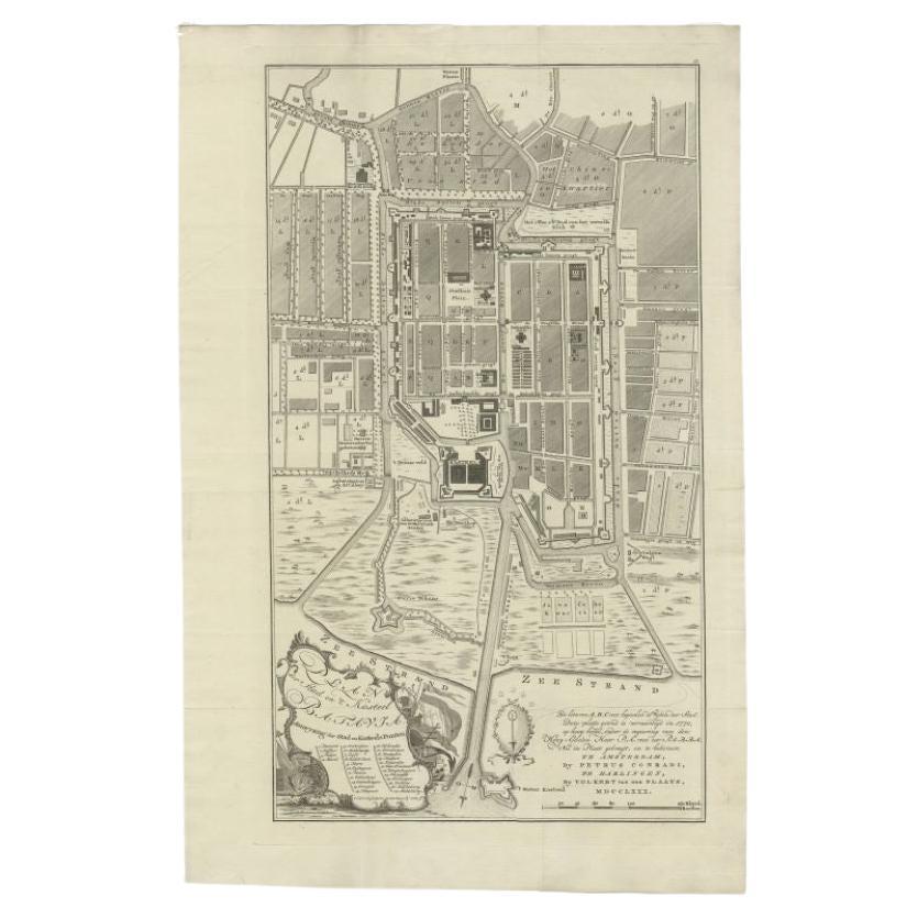
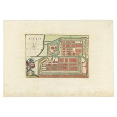
Antique Plan of Batavia, Nowadays Jakarta, Indonesia, 1780
Located in Langweer, NL
Antique map titled 'Plan der Stad en 't Kasteel Batavia'. A very rare late 18th century detailed plan of Batavia with an alpha-numeric key showing the main areas and buildings (only ...
Category
Antique 18th Century Maps
Materials
Paper

$1,746 Sale Price
20% Off
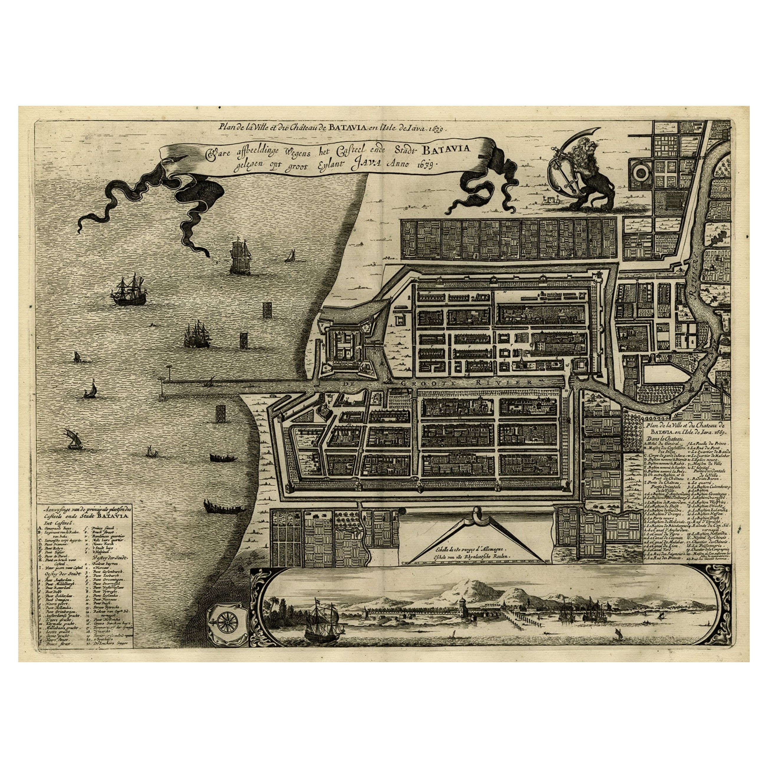
Antique Map of Batavia, Dutch East Indies, Nowadays Jakarta, Indonesia, ca.1669
Located in Langweer, NL
Antique map titled 'Ware afbeeldinge wegens het Casteel ende Stadt Batavia gelegen opt groot Eylant Java Anno 1679. Plan de la Ville et du Chateau de Batavia en l'Isle de Iava. 1679....
Category
Antique 1660s Maps
Materials
Paper
$1,275 Sale Price
20% Off
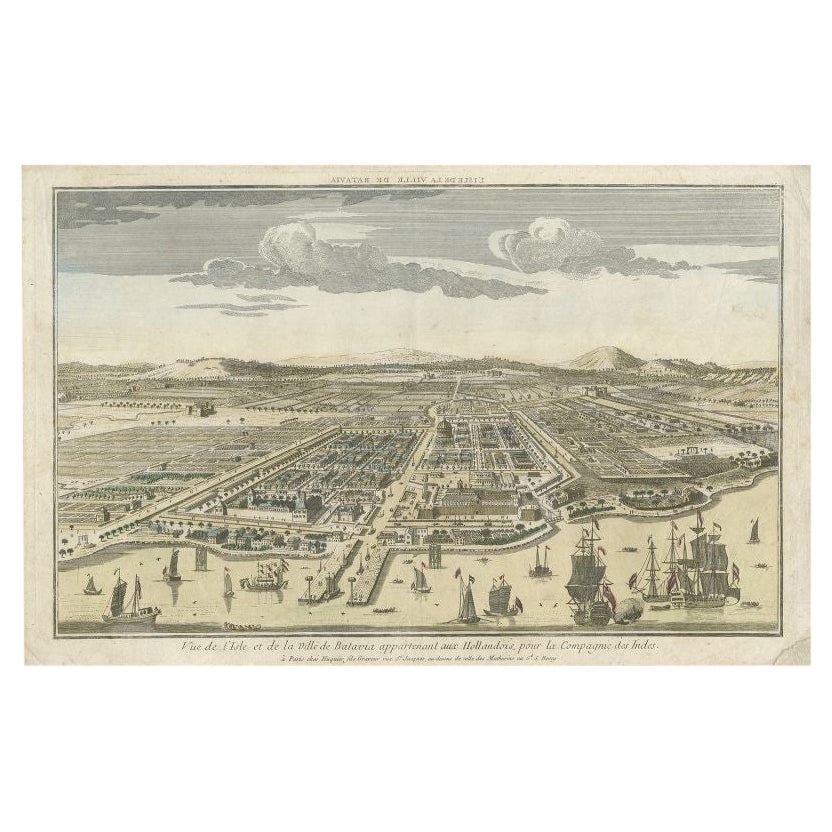
Antique Print of Batavia or nowadays Jakarta, Indonesia, c.1755
Located in Langweer, NL
Antique print titled 'Vue de l'Isle et de la ville de Batavia appartenant aux Hollandois'. Beautiful view of the island and the city of Batavia belonging to the Dutch, for the India ...
Category
Antique 18th Century Prints
Materials
Paper
$689 Sale Price
20% Off
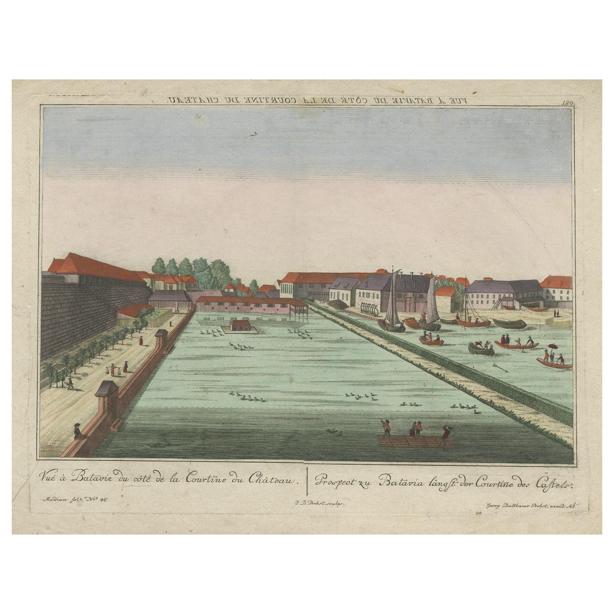
Antique Print of Batavia Castle in Nowadays Jakarta, Indonesia, circa 1770
Located in Langweer, NL
Antique print titled 'Vue a Batavie du côte de la Courtine du Château - Prospect zu Batavia längst der Courtine des Castels'. Scarce view of Batavia Castle, present day Djakarta, Ind...
Category
Antique 18th Century Prints
Materials
Paper
$519 Sale Price
20% Off
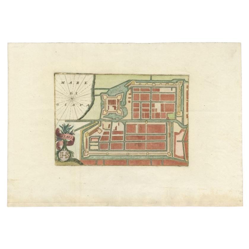
Antique Plan of Batavia in the Dutch East Indies or Nowadays Jakarta, Indonesia
Located in Langweer, NL
Rare plan of Batavia titled 'Batavia'. With 'IHS' monogram, symbolizing Jesus Christ. Source unknown, to be determined.
Artists and Enrgavers: Anonymous.
Condition: Very good,...
Category
Antique 18th Century Maps
Materials
Paper
$841 Sale Price
20% Off
You May Also Like
1864 Map of North America, Antique Hand-Colored Map, by Adolphe Hippolyte Dufour
Located in Colorado Springs, CO
Offered is a map of North America entitled Amerique du Nord from 1864. This rare, separately published wall map was produced by Adolphe Hippolyte Dufour. This map includes vibrant an...
Category
Antique 1860s French Maps
Materials
Paper

Staffordshire 1645 Hand Colored Antique Print Staffordiensis Comitatvs Map
Located in West Sussex, Pulborough
We are delighted to offer for sale this lovely antique Atlas page map of Staffordshire printed in 1645 Amsterdam Staffordiensis Comitatvs Vulgo
This o...
Category
Antique Early 1800s English Georgian Maps
Materials
Paper

$427 Sale Price
30% Off
Wychmere Harbor Allens Harbor Map Circa 1890
Located in Norwell, MA
Map of Harwich Mass showing Wychmere Harbor, Doane's Creek, Allens Harbor, Herring River, Pleasant Lake, Grassy Pond, Paddocks Pond, Hinkleys Pond, etc., This is an original period m...
Category
Antique 1890s North American Maps
Materials
Paper
Double Sided Northamptonshire 1645 Hand Colored Antique Print Map Rare Find
Located in West Sussex, Pulborough
We are delighted to this lovely antique Atlas page map of Northamptonshire printed in 1645 Amsterdam Staffordiensis Comitatvs Vulgo
I have three of th...
Category
Antique Early 1800s English Georgian Maps
Materials
Paper

$427 Sale Price
30% Off
17th Century Hand-Colored Map of a Region in West Germany by Janssonius
By Johannes Janssonius
Located in Alamo, CA
This attractive highly detailed 17th century original hand-colored map is entitled "Archiepiscopatus Maghdeburgensis et Anhaltinus Ducatus cum terris adjacentibus". It was published ...
Category
Antique Mid-17th Century Dutch Maps
Materials
Paper

Colored wall map of the WORLD
By Chambon
Located in ZWIJNDRECHT, NL
“Mappe Monde, contenant les Parties Connues du Globe Terrestre”
CHAMBON, Gobert-Denis (France, 17.. - 1781)
Paris, Longchamps et Janvier, 1754
Size H. 115 x W. 145 cm.
Gobert-Denis Chambon made copper engraving after the work of Guillaume De L’Isle, published in 1754 by Jean Janvier and S.G. Longschamps.
A huge wall map of the world in two hemispheres printed on two sheets, depicting the Eastern and Western hemispheres supported by two male figures, decorated at the bottom right and left with two celestial hemispheres (boreal and southern) and at the bottom in the middle with an armillary sphere, in addition.
This map is most notable for its depiction of the Sea of Japan labeled "Mer de Corée" and of "Mer de L'Ouest" or Sea of the West - a great sea, easily the size of the Mediterranean, to flow from the then-known Strait of Juan de Fuca...
Category
Antique Mid-18th Century French French Provincial Maps
Materials
Wood, Paper

More Ways To Browse
Vintage Art Deco Rugs
Vintage Serving Forks
Herati Rug
Italian Wood Console Tables
Maison Jansen Argentina
Antique Oushak
Mid Century Danish Directors Chairs
Moller 70
Wood Relief Art
Argentina Travel Poster
Century Furniture Faux Bamboo
Early American Chairs
Hans Muller
Vintage Wood Table With Glass Top
19th Century Square Table
Antonio Bonet
Galle Chairs
Large Chinese Rug