Items Similar to Bordeaux City View – Braun & Hogenberg Original Woodcut, ca. 1575
Want more images or videos?
Request additional images or videos from the seller
1 of 10
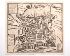
Bordeaux City View – Braun & Hogenberg Original Woodcut, ca. 1575
$887.39
£660.13
€740
CA$1,215.14
A$1,351.07
CHF 705.46
MX$16,445.87
NOK 9,001.32
SEK 8,433.80
DKK 5,633.21
Shipping
Retrieving quote...The 1stDibs Promise:
Authenticity Guarantee,
Money-Back Guarantee,
24-Hour Cancellation
About the Item
Bordeaux City View – Braun & Hogenberg Original Woodcut, ca. 1575
Description:
This detailed and highly decorative bird’s-eye view of Bordeaux, titled Bovrdeavx, originates from the renowned 16th-century city atlas Civitates Orbis Terrarum, compiled by Georg Braun and engraved by Frans Hogenberg. First published in Cologne between 1572 and 1617, the Civitates is considered the most important and comprehensive collection of early modern city views ever produced.
The engraving shows the French port city of Bordeaux as it appeared in the mid-16th century, viewed from the Garonne River, with ships sailing into the harbor and prominent buildings rising from the fortified city. The layout reveals the structured street plan, with marketplaces, churches, towers, and surrounding vineyards and countryside. A detailed legend in the left margin identifies key structures (A to N), including the Cathedral of Saint-André, the Grosse Cloche, and the Roman amphitheater.
Rich Renaissance-style cartouches frame the view, with stylized scrollwork and corner embellishments. The reverse side features letterpress text in Gothic type, providing a contemporary description of the city in Latin or German. This helps to authenticate the print as part of an early edition of the atlas, likely from around 1575–1580.
This map is both a beautiful decorative object and a valuable historical document, offering a rare visual insight into urban life and city planning during the Renaissance. Collectors prize Braun & Hogenberg views for their artistic merit, historical accuracy, and geographical interest.
Condition report:
Good impression on laid paper with wide margins. Letterpress text on the reverse. Light age-toning and minor foxing in the margins. No tears or restorations. Plate mark and woodcut lines are sharp and well-defined. A well-preserved and authentic example of early modern cartography.
Framing tips:
This piece deserves archival framing with a wide ivory or antique-white mat and a dark wood or gold-accented Renaissance-style frame. UV-protective glass is recommended to preserve the early paper and ink.
Technique: Woodcut with letterpress on verso
Maker: Georg Braun & Frans Hogenberg, Cologne, ca. 1575
- Dimensions:Height: 13 in (33 cm)Width: 15.95 in (40.5 cm)Depth: 0.01 in (0.2 mm)
- Materials and Techniques:Paper,Engraved
- Place of Origin:
- Period:
- Date of Manufacture:circa 1575
- Condition:Good impression on laid paper with wide margins. Letterpress text on the reverse, with some show through on the left. Light age-toning and minor foxing in the margins. No tears or restorations. Plate mark and woodcut lines are sharp and well-defined.
- Seller Location:Langweer, NL
- Reference Number:Seller: BG-12875-21stDibs: LU3054346026902
About the Seller
5.0
Recognized Seller
These prestigious sellers are industry leaders and represent the highest echelon for item quality and design.
Platinum Seller
Premium sellers with a 4.7+ rating and 24-hour response times
Established in 2009
1stDibs seller since 2017
2,511 sales on 1stDibs
Typical response time: <1 hour
- ShippingRetrieving quote...Shipping from: Langweer, Netherlands
- Return Policy
Authenticity Guarantee
In the unlikely event there’s an issue with an item’s authenticity, contact us within 1 year for a full refund. DetailsMoney-Back Guarantee
If your item is not as described, is damaged in transit, or does not arrive, contact us within 7 days for a full refund. Details24-Hour Cancellation
You have a 24-hour grace period in which to reconsider your purchase, with no questions asked.Vetted Professional Sellers
Our world-class sellers must adhere to strict standards for service and quality, maintaining the integrity of our listings.Price-Match Guarantee
If you find that a seller listed the same item for a lower price elsewhere, we’ll match it.Trusted Global Delivery
Our best-in-class carrier network provides specialized shipping options worldwide, including custom delivery.More From This Seller
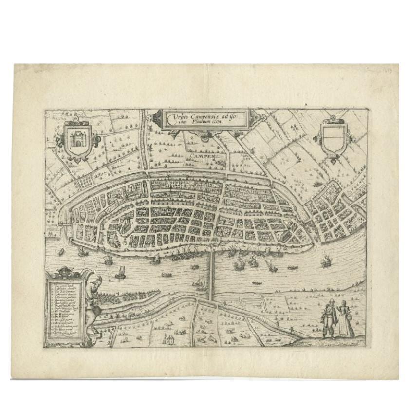
View AllAntique Map of the City of Kampen by Guicciardini, 1613
Located in Langweer, NL
Antique map titled 'Urbis Campensis (..)'. Plan of the city of Kampen, the Netherlands. This map originates from the 1613 edition of 'Discrittione di tutti i Paesi Bassi', by L. Guic...
Category
Antique 17th Century Maps
Materials
Paper

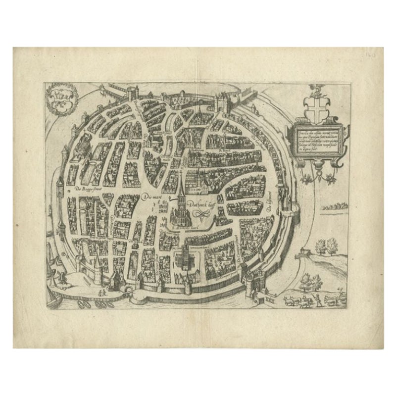
Antique Map of the City of Zwolle by Guicciardini, 1613
Located in Langweer, NL
Antique map titled 'Swolla'. Map of the city of Zwolle, the Netherlands. This map originates from the 1613 edition of 'Discrittione di tutti i Paesi Bassi', by L. Guicciardini, publi...
Category
Antique 17th Century Maps
Materials
Paper

$206 Sale Price
20% Off
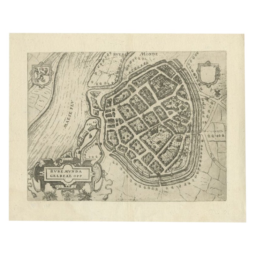
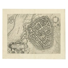
Antique Map of the City of Roermond by Guicciardini, 1613
Located in Langweer, NL
Antique map titled ‚Ruremunda Gelriae Opp‘. Plan of Roermond in the province of Limburg, The Netherlands, Holland. This map originates from the 1613 edition of 'Discrittione di tutti...
Category
Antique 17th Century Maps
Materials
Paper
$213 Sale Price
20% Off
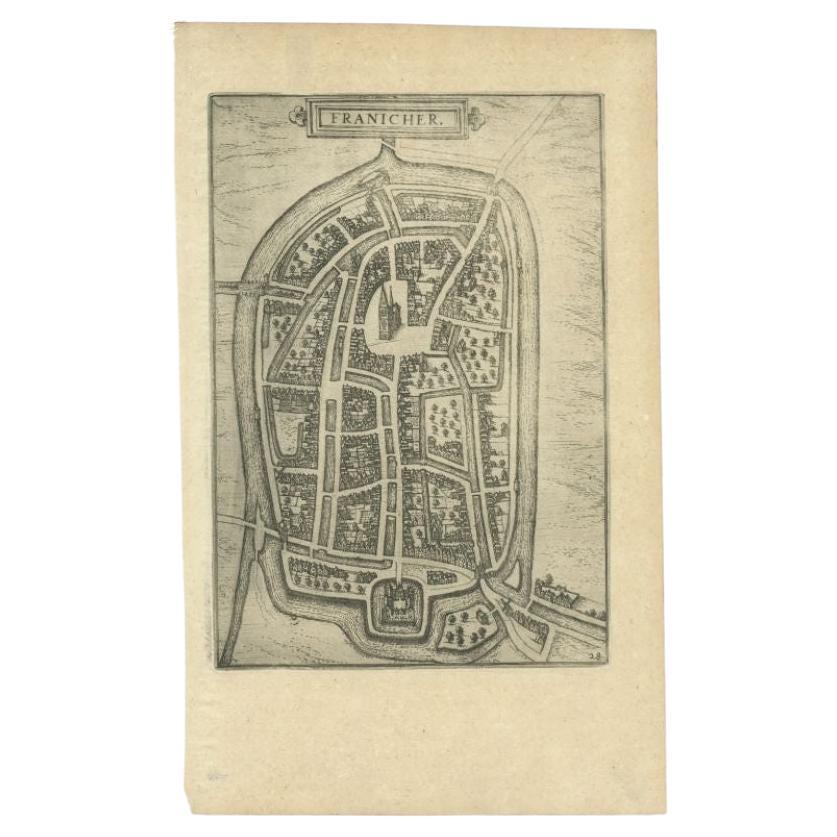
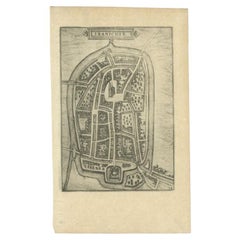
Antique Map of the City of Franeker by Guicciardini, 1613
Located in Langweer, NL
Antique map titled 'Franicher'. Plan of the city of Franeker, Friesland, the Netherlands. This map originates from the 1613 edition of 'Discrittione di tutti i Paesi Bassi', by L. Gu...
Category
Antique 17th Century Maps
Materials
Paper
$115 Sale Price
20% Off
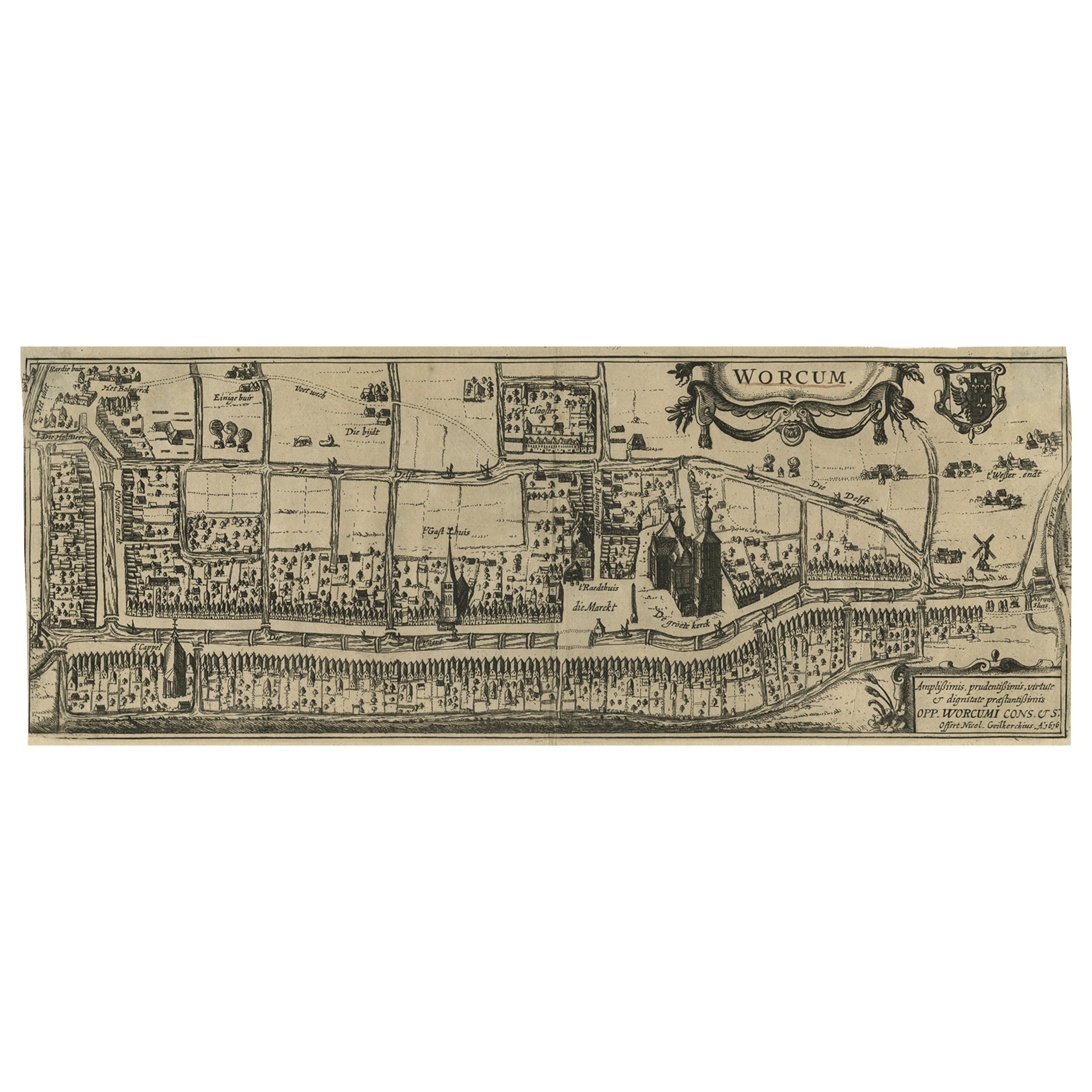
Original Old & Rare View of the City of Workum, Friesland, The Netherlands, 1616
Located in Langweer, NL
Antique map titled 'Worcum'. This print depicts the city of Workum (Friesland, The Netherlands). With German captions. This print originates from 'Rerum Frisicarum Historia' publishe...
Category
Antique 1610s Maps
Materials
Paper

$402 Sale Price
20% Off
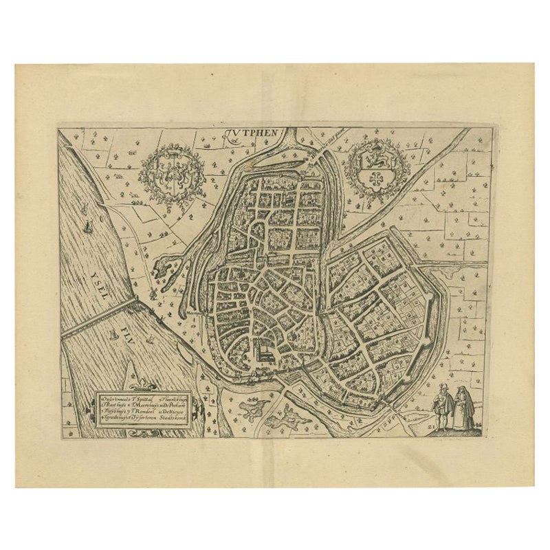
Antique Map of the City of Zutphen by Guicciardini, 1612
Located in Langweer, NL
Antique map Zutphen titled 'Zutphen'. This map depicts the city of Zutphen, Gelderland, The Netherlands. Originates from 'Beschryvinghe van alle de Neder-landen anderssins ghenoemt N...
Category
Antique 17th Century Maps
Materials
Paper

$180 Sale Price
20% Off
You May Also Like
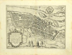
View of La Rochelle - Etching by G. Braun and F. Hogenberg - Late 16th Century
By Franz Hogenberg
Located in Roma, IT
This View of La Rochelle (ancient name: Rochel) is an original etching realized by George Braun and Franz Hogenberg as part of the famous Series "Civitates Orbis Terrarum".
The “Civ...
Category
16th Century Figurative Prints
Materials
Etching
17th Century Topographical Engraving Nantes & St. Malo, France, by Iohan Peeters
Located in New York, NY
The ancient city of Saint Malo in North Western France has long been associated with adventure on the high seas, piracy and exploration. It was the birthplace of several important in...
Category
Antique 17th Century Dutch Maps
Materials
Paper

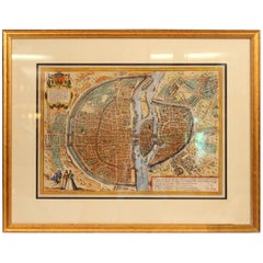
Old Engraving Map of Paris French Munster 16th Century Walled City Framed
Located in Wilton, CT
Old or antique colored engraving of Munster's 1572 map of Paris, circa 19th or 20th century (Frame was not opened to look for a publication ...
Category
20th Century French Renaissance Prints
Materials
Paper
$950 Sale Price
36% Off
Map of Magdeburg - Etching by G. Braun e F. Hogenberg - Late 16th Century
By Franz Hogenberg
Located in Roma, IT
This map of Magdebvrgvm is an original etching realized by George Braun and Frans Hogenberg, as part of the famous series "Civitates Orbis Terrarum" (Atlas of the Cities of the Worl...
Category
16th Century Figurative Prints
Materials
Etching
City of Neus - Original Etching by F. Hogenberg - Late 16th Century
By Franz Hogenberg
Located in Roma, IT
City of Neus is an original etching realized by Georg Braun and Franz Hogenberg as part of the famous Series "Civitates Orbis Terrarum".
Precious etch...
Category
16th Century Figurative Prints
Materials
Etching
Map of Nijmegen - Etching by G. Braun and F. Hogenberg - Late 16th Century
By Franz Hogenberg
Located in Roma, IT
This map of Noviomagvs is an original etching realized by Georg Braun and Franz Hogenberg as part of the famous series "Civitates Orbis Terrarum".
The state of preservation of the ...
Category
16th Century Figurative Prints
Materials
Etching
