Items Similar to Detailed Antique Map of Italy and surrounding Islands

Want more images or videos?
Request additional images or videos from the seller
1 of 6
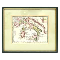
Detailed Antique Map of Italy and surrounding Islands
$586
$732.5020% Off
£439.24
£549.0520% Off
€496
€62020% Off
CA$805.07
CA$1,006.3320% Off
A$898.78
A$1,123.4720% Off
CHF 470.95
CHF 588.6820% Off
MX$11,001.94
MX$13,752.4320% Off
NOK 5,981.03
NOK 7,476.2920% Off
SEK 5,639.35
SEK 7,049.1920% Off
DKK 3,775.73
DKK 4,719.6720% Off
About the Item
Antique map titled 'Italie volgens de allernieuwste Uitgave van den Heere d'Anville'. Very detailed antique map, based on D'Anville's important map of Italy. The map extends to Sicily, Corsica, Sardinia, and Mallorca (Majorca). A small inset shows Malta in relation to Sicily. The title is enclosed in a decorative cartouche. Published by I. Tirion, dated 1761.
Tirion was born in Utrecht in 1705. He moved to Amsterdam in 1725 and set up shop on Damrak as a book publisher. Tirion quick rose in prominence by publishing pamphlets, historical works, and, most importantly, maps and atlases. He eventually relocated his printing house to the prestigious Kalverstraat. In his long career he produced eight atlases in multiple editions, some of which were published posthumously until about 1784. Most of his cartographic work is based on the earlier maps of Guillaume de L'Isle.
- Dimensions:Height: 16.5 in (41.9 cm)Width: 18.82 in (47.8 cm)Depth: 0.02 in (0.5 mm)
- Materials and Techniques:
- Period:
- Date of Manufacture:1761
- Condition:General age-related toning. Beautiful hand coloring. Original folding lines, one small closed split top margin. Minor wear, blank verso. Please study image carefully.
- Seller Location:Langweer, NL
- Reference Number:Seller: BG-135091stDibs: LU3054335846092
About the Seller
5.0
Recognized Seller
These prestigious sellers are industry leaders and represent the highest echelon for item quality and design.
Platinum Seller
Premium sellers with a 4.7+ rating and 24-hour response times
Established in 2009
1stDibs seller since 2017
2,513 sales on 1stDibs
Typical response time: <1 hour
- ShippingRetrieving quote...Shipping from: Langweer, Netherlands
- Return Policy
Authenticity Guarantee
In the unlikely event there’s an issue with an item’s authenticity, contact us within 1 year for a full refund. DetailsMoney-Back Guarantee
If your item is not as described, is damaged in transit, or does not arrive, contact us within 7 days for a full refund. Details24-Hour Cancellation
You have a 24-hour grace period in which to reconsider your purchase, with no questions asked.Vetted Professional Sellers
Our world-class sellers must adhere to strict standards for service and quality, maintaining the integrity of our listings.Price-Match Guarantee
If you find that a seller listed the same item for a lower price elsewhere, we’ll match it.Trusted Global Delivery
Our best-in-class carrier network provides specialized shipping options worldwide, including custom delivery.More From This Seller
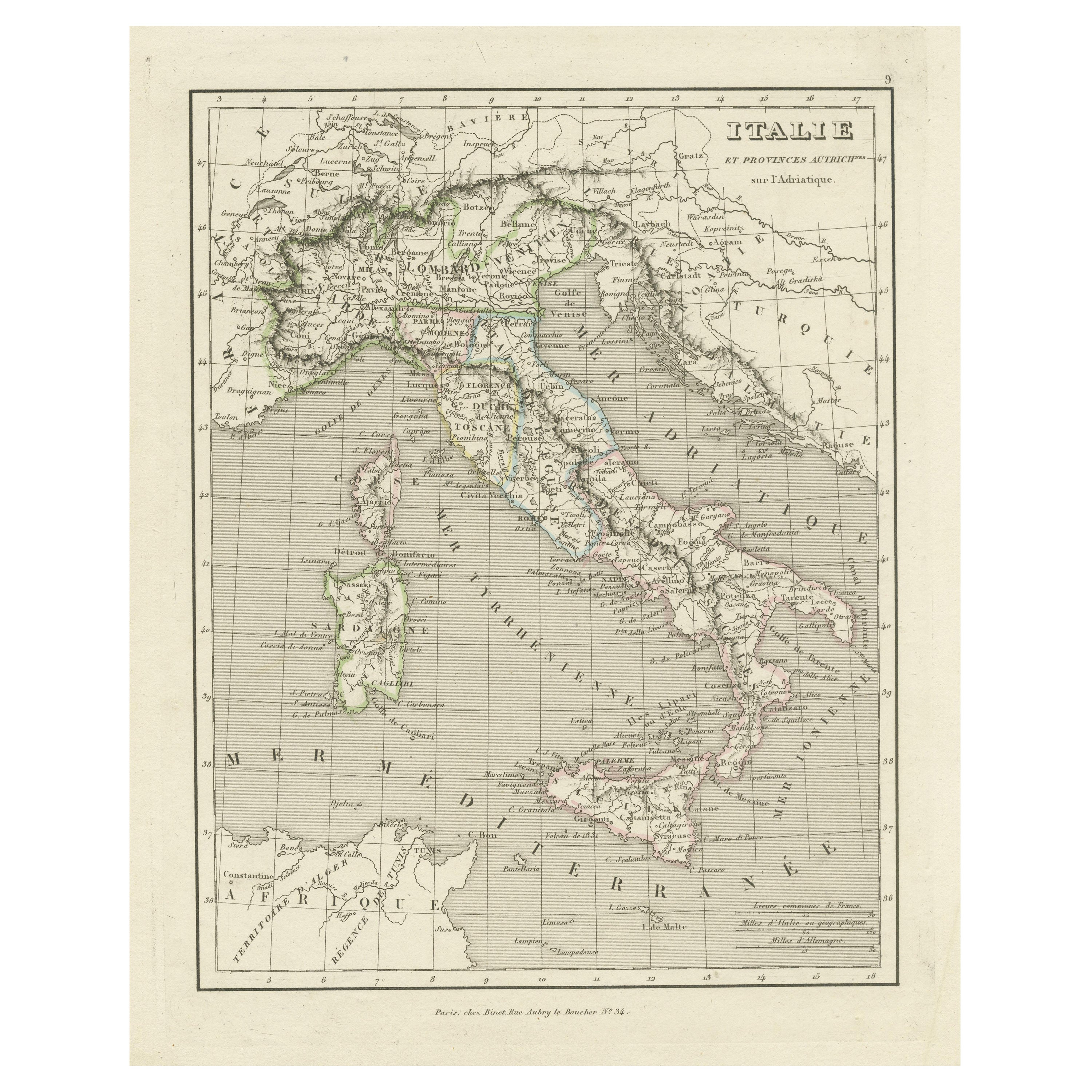
View AllAntique Map of Italy and Other Regions Near the Adriatic Sea
Located in Langweer, NL
Antique map titled 'Italie et Provinces Autrichnes sur l'Adriatique'. Original old map of Italy and surroundings. Also shows Sicily and Sardinia. Ori...
Category
Antique Mid-19th Century Maps
Materials
Paper
$160 Sale Price
20% Off
Antique Map of Italy, 1903, Featuring Islands of Sardinia and Sicily
Located in Langweer, NL
Title: Antique Map of Italy, 1903, Featuring Islands of Sardinia and Sicily
Description:
This finely detailed antique map, titled "Italy," was engraved and published in 1903 by the ...
Category
Early 20th Century Maps
Materials
Paper
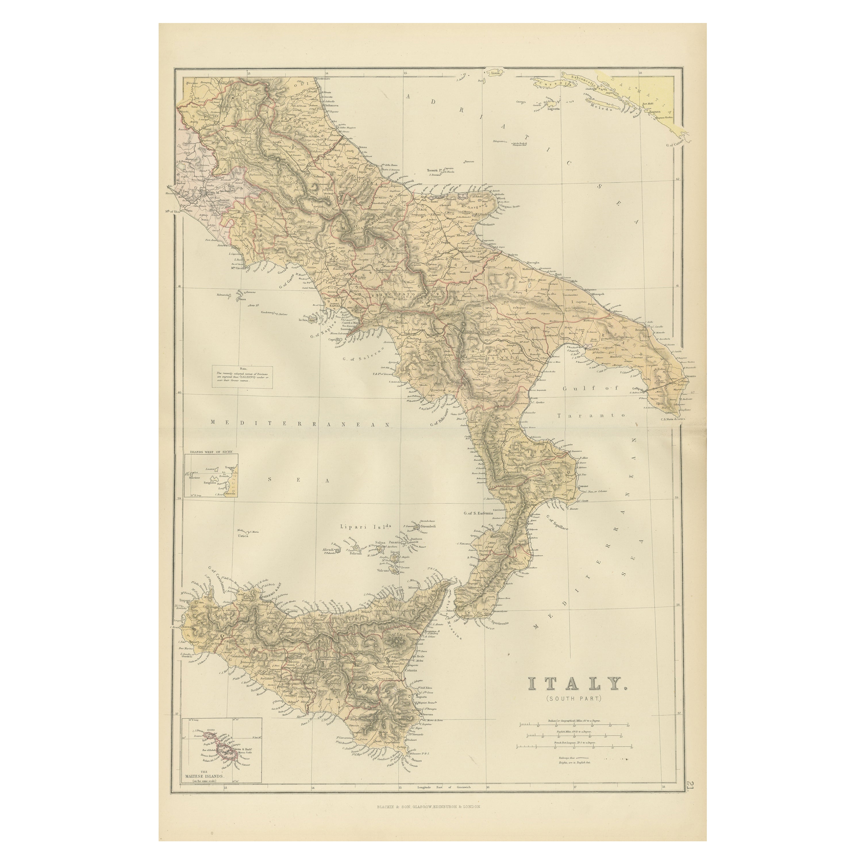
Original Antique Map of the South Part of Italy with an Inset of Malta, 1882
Located in Langweer, NL
Embark on a captivating journey through the southern part of Italy with an original Antique Map from the esteemed 'Comprehensive Atlas and Geography of the World,' meticulously craft...
Category
Antique 1880s Maps
Materials
Paper
$198 Sale Price
20% Off
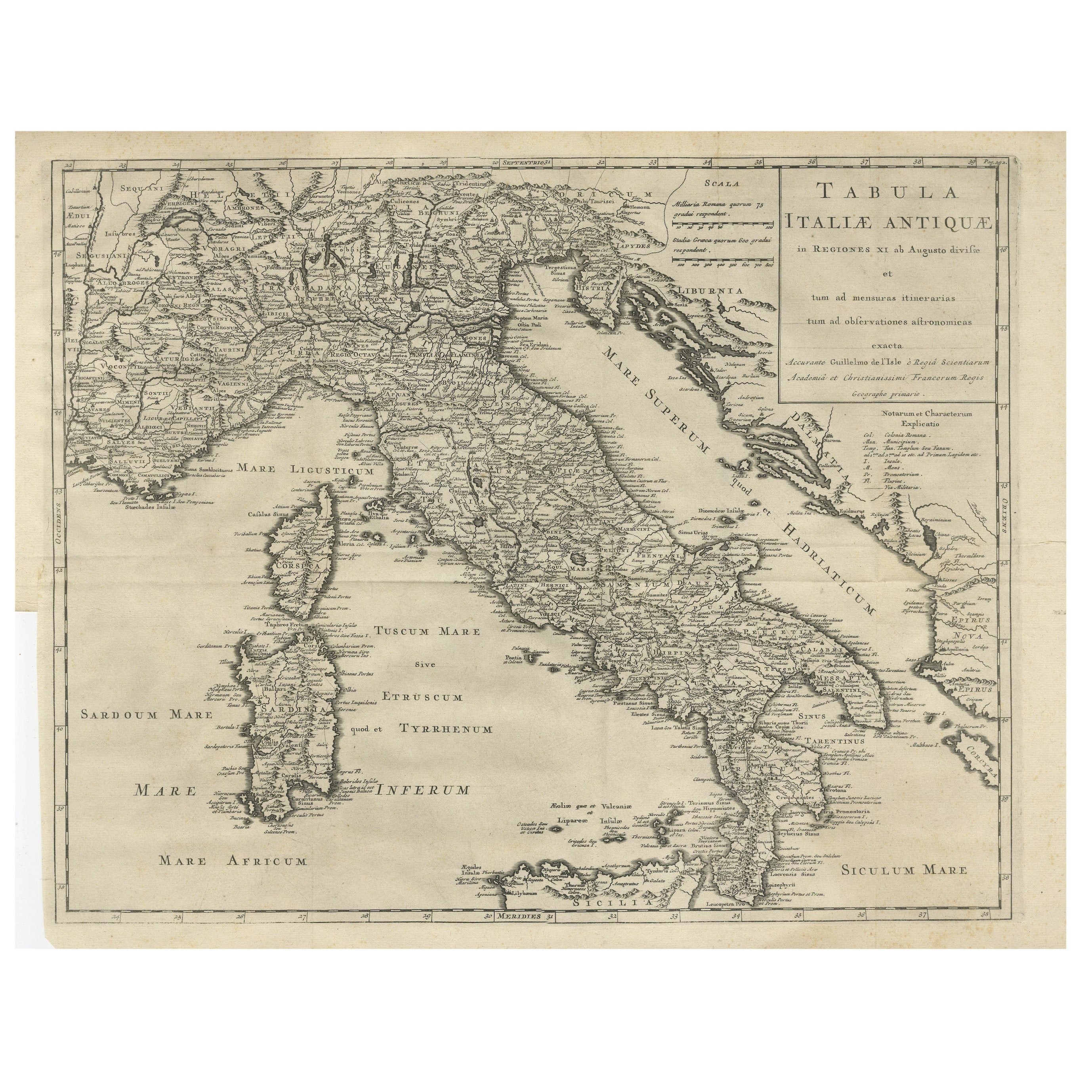
Antique Engraved Map of Italy in Roman Times, ca.1730
Located in Langweer, NL
Plain engr. map of Italy according to the division of Emperor Augustus by G. Delisle.
Title: "Tabula Italiae Antiquae In Regiones XI Ab Augusto Divisae Et Tum Ad Mensuras Itinerari...
Category
Antique 1730s Maps
Materials
Paper
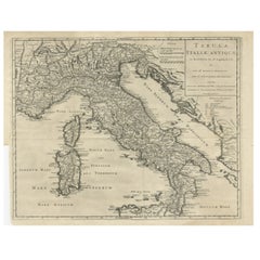
$642 Sale Price
20% Off
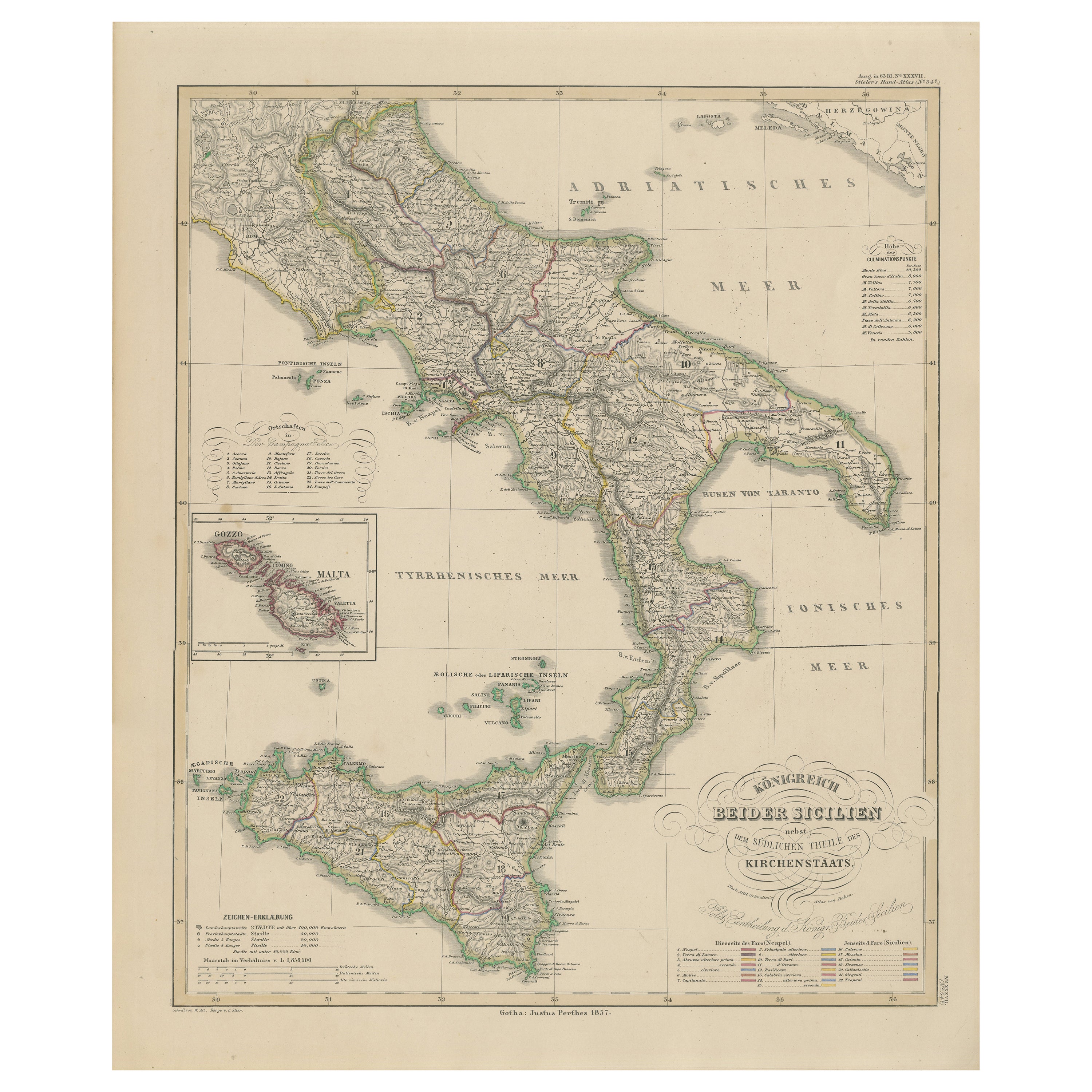
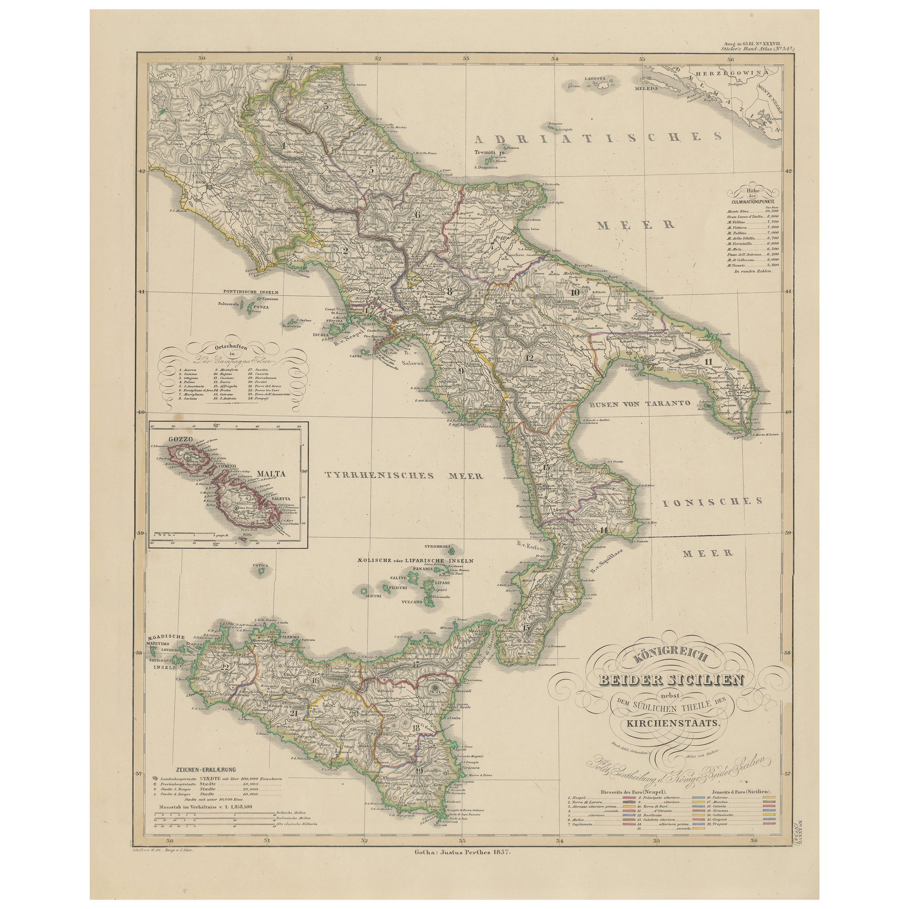
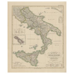
Kingdom of the Two Sicilies Map – Southern Italy and Sicily 1857
Located in Langweer, NL
Kingdom of the Two Sicilies Map – Southern Italy and Sicily 1857
This detailed antique print shows the “Königreich Beider Sicilien nebst dem südlichen Theile des Kirchenstaats” mean...
Category
Antique Mid-19th Century German Maps
Materials
Paper
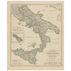
Kingdom of the Two Sicilies Map – Southern Italy and Sicily 1857
Located in Langweer, NL
Kingdom of the Two Sicilies Map – Southern Italy and Sicily 1857
This detailed antique print shows the “Königreich Beider Sicilien nebst dem südlichen Theile des Kirchenstaats” mean...
Category
Antique Mid-19th Century German Maps
Materials
Paper
You May Also Like
Large Original Antique Map of Italy. John Dower, 1861
Located in St Annes, Lancashire
Great map of Italy
Lithograph engraving by John Dower
Original colour
Published, 1861
Unframed
Good condition / repair to top right corner seen in last image
Category
Antique 1860s English Victorian Maps
Materials
Paper

Geographical Map of Italy
Located in Alessandria, Piemonte
BOLIS Publishing House - Bergamo.
A beautiful large map of Italy, on paper but suitably reinforced to preserve it correctly. The maps were usually p...
Category
Mid-20th Century Italian Other Prints
Materials
Paper

Italy, Central and Southern Part. Century Atlas antique map
Located in Melbourne, Victoria
'The Century Atlas. Italy, Central and Southern Part.'
Original antique map, 1903.
Inset maps of Sicily and Naples.
Central fold as issued. Map name an...
Category
Early 20th Century Victorian More Prints
Materials
Lithograph

Italy, Sicily, Sardinia, Corsica and Dalmatian Coast: A 17th Century Dutch Map
By Theodorus Danckerts
Located in Alamo, CA
This hand colored 17th century Dutch map entitled "Novissima et Accuratissima totius Italiae Corsicae et Sardiniae Descriptio" by Theodore Danckerts depicts the Italian Peninsula in ...
Category
Antique Late 17th Century Dutch Maps
Materials
Paper

Large Original Antique Map of The South of Italy. John Dower, 1861
Located in St Annes, Lancashire
Great map of the South of Italy
Lithograph engraving by John Dower
Original colour
Published, 1861
Unframed
Good condition
Free shipping
Category
Antique 1860s English Victorian Maps
Materials
Paper

1970s Framed Antique Map of Italy 1746 Original
Located in Nuernberg, DE
An extraordinary original antique map, framed in the 1970s by Brehm Nuremberg, Germany, showing Italy. Map is dated 1746 and approx. 7 ¼" wide and 5 ¾" high in viewable size. Framed ...
Category
Vintage 1970s Decorative Art
Materials
Glass, Wood
More Ways To Browse
Long Island Used Furniture
Antique Maltese
Antique Maltese Furniture
Malta Antique
18th Century Maltese Furniture
Giacometti Chairs
Antique Rug Wool Navy Blue Red
Bauhaus Flower Stand
French Table With Drawers
North Carolina Furniture
Antique Silver Platter
Boat Blueprint
Cream Plates
Vintage Art Deco Rugs
Vintage Serving Forks
Brewery Signs
Herati Rug
Venice Wood