Items Similar to Early Woodcut Map of Swabia and Bavaria in Germany, 1628

Want more images or videos?
Request additional images or videos from the seller
1 of 6
Early Woodcut Map of Swabia and Bavaria in Germany, 1628
$567.10
£425.07
€480
CA$779.10
A$869.79
CHF 455.76
MX$10,647.04
NOK 5,788.09
SEK 5,457.44
DKK 3,653.94
About the Item
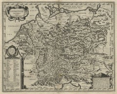
Title: Early Woodcut Map of Swabia and Bavaria, 16th Century
This early woodcut map titled "Schwaben und Bayernlande / Darbey auch begreiffen der Oenwaldt / Nordgaw / etc." provides a detailed depiction of the historical regions of Swabia (Schwaben) and Bavaria (Bayern) in Germany. The map showcases the geographic layout of cities, towns, rivers, and mountains, capturing the complex landscape of southern Germany during the 16th century.
The map is adorned with several descriptive inscriptions and a decorative title. The pictorial representation of the Alps and the rugged terrain in the northern section, along with the elaborate detailing of towns and cities, reflects the style of Renaissance cartography, where geographic accuracy was often combined with artistic flair.
The text along the top and bottom edges of the map serves as a reference to the region's boundaries and notable features, providing further context to the depicted territories. These maps were used not only as geographic references but also to display the political and territorial divisions of the Holy Roman Empire during this era.
Here are the translations of the text blocks:
1. Top-Center Text Block:
"Bavaria is enclosed by mountains to the south and north, richly blessed with mountains and forests, covered with beautiful meadows and especially dense woods, with many rivers and lakes, traversed by the Danube, and adorned with many fruitful fields, beautiful cities, castles, monasteries, and villages."
2. Top-Left Text Block:
"Swabia is a noble land in terms of location and fertility; mountains, valleys, forests, fields, orchards, gardens, fine food and drink, pure water, and fresh air. A place of the noblest and finest people, diligent, industrious, talented, upright, and God-fearing folk."
Condition report: Well-preserved with light toning consistent with age. Minor foxing along the edges. The paper remains crisp, and the details are clear, making it a charming example of early cartographic art.
- Dimensions:Height: 14.45 in (36.7 cm)Width: 16.26 in (41.3 cm)Depth: 0.01 in (0.2 mm)
- Materials and Techniques:Paper,Engraved
- Period:1620-1629
- Date of Manufacture:1628
- Condition:Condition report: Very good. Well-preserved with minor toning consistent with age. The print is crisp, and the details remain clear, with slight foxing in the margins. Overall, it is a charming and well-kept example of early cartography.
- Seller Location:Langweer, NL
- Reference Number:Seller: BG-13842-81stDibs: LU3054342576102
About the Seller
5.0
Recognized Seller
These prestigious sellers are industry leaders and represent the highest echelon for item quality and design.
Platinum Seller
Premium sellers with a 4.7+ rating and 24-hour response times
Established in 2009
1stDibs seller since 2017
2,513 sales on 1stDibs
Typical response time: <1 hour
- ShippingRetrieving quote...Shipping from: Langweer, Netherlands
- Return Policy
Authenticity Guarantee
In the unlikely event there’s an issue with an item’s authenticity, contact us within 1 year for a full refund. DetailsMoney-Back Guarantee
If your item is not as described, is damaged in transit, or does not arrive, contact us within 7 days for a full refund. Details24-Hour Cancellation
You have a 24-hour grace period in which to reconsider your purchase, with no questions asked.Vetted Professional Sellers
Our world-class sellers must adhere to strict standards for service and quality, maintaining the integrity of our listings.Price-Match Guarantee
If you find that a seller listed the same item for a lower price elsewhere, we’ll match it.Trusted Global Delivery
Our best-in-class carrier network provides specialized shipping options worldwide, including custom delivery.More From This Seller
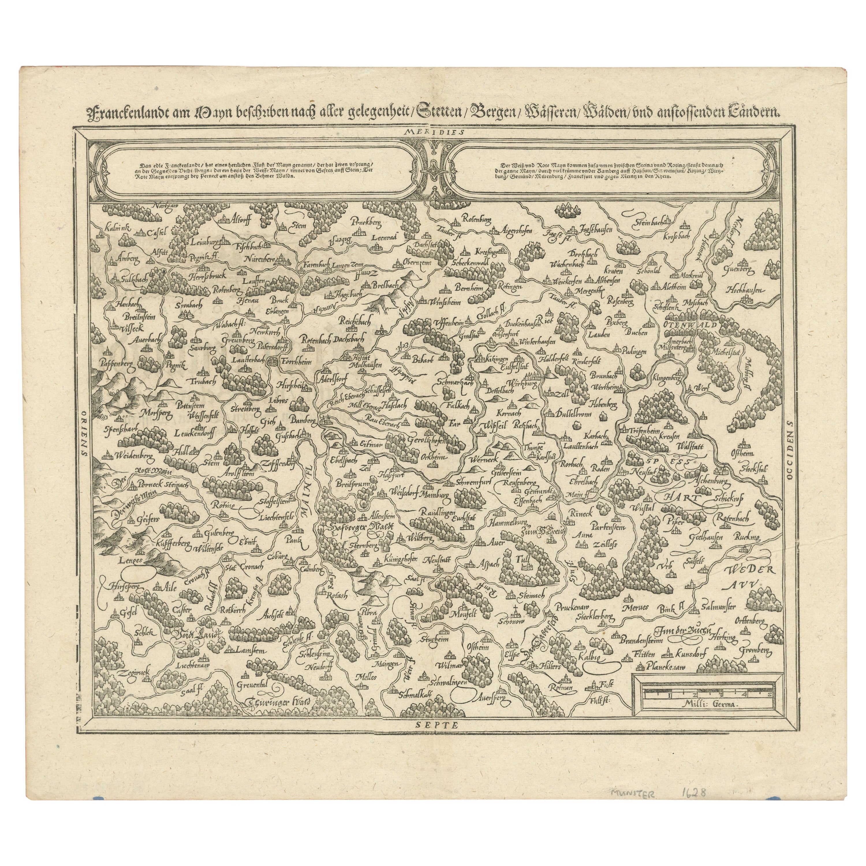
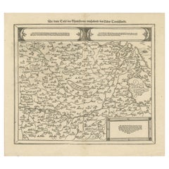
View AllEarly Woodcut Map of Franconia and Surrounding Regions, 1628
Located in Langweer, NL
Title: Early Woodcut Map of Franconia and Surrounding Regions, 1628
Franconia (Franckenlande) is a region in Germany. Historically, Franconia was a significant part of the Holy Roma...
Category
Antique 1620s Maps
Materials
Paper
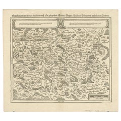
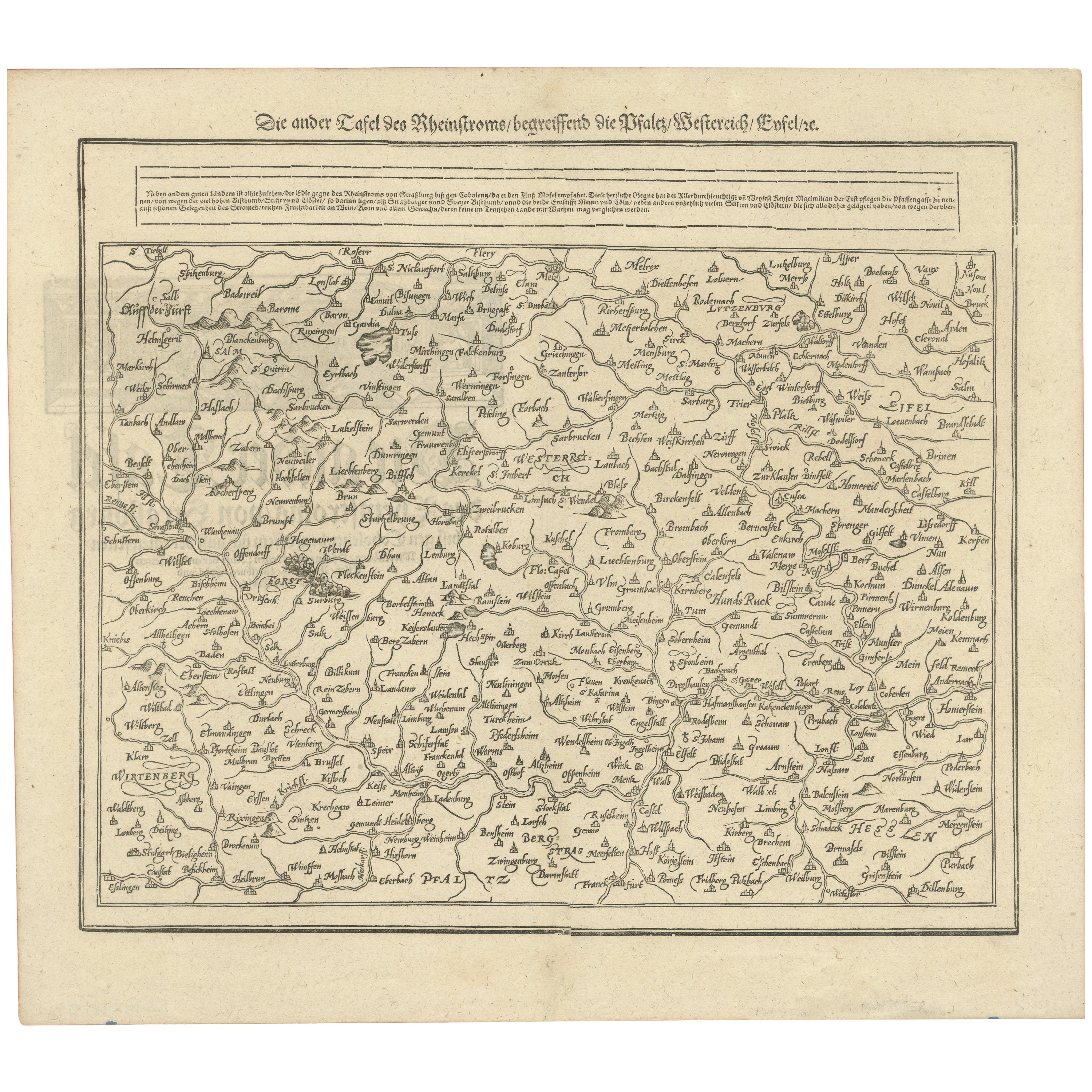
Woodcut Map of the Rhine River Region Covering the Palatinate, Austria and Elsa
Located in Langweer, NL
Early Woodcut Map of the Rhine River Region Covering the Palatinate, Austria, and Elsass, ca. 1628
This early woodcut map, titled "Die ander Tafel des Rheinstromes/begriffen die Pfa...
Category
Antique 1620s Maps
Materials
Paper
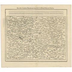
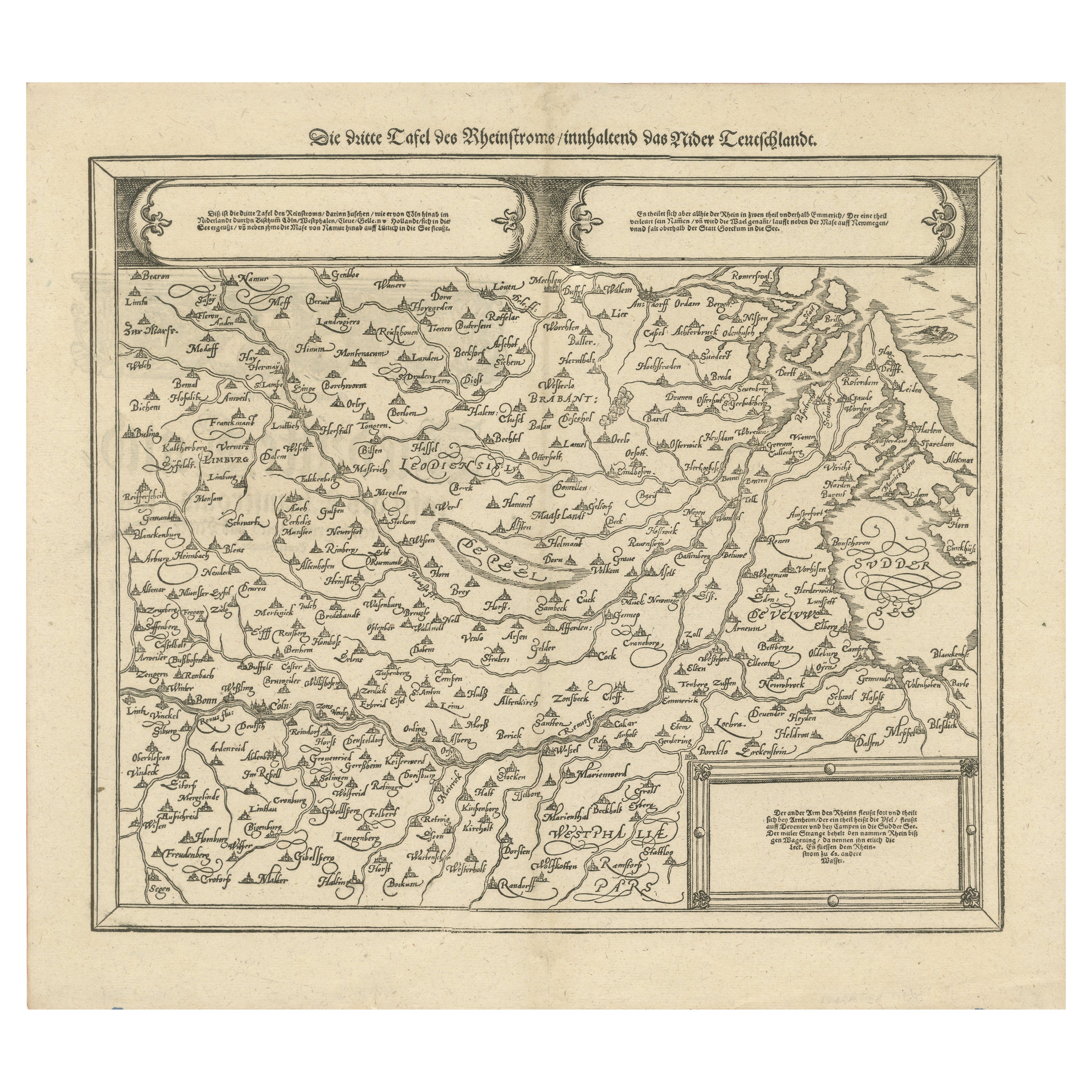
Early Woodcut Map of the Rhine River Region in Germany and Holland, circa 1628
Located in Langweer, NL
Early Woodcut Map of the Rhine River Region, "Die Dritte Tafel des Rheinstroms," ca. 16th Century
This early woodcut map, titled "Die Dritte Tafel des Rheinstroms Innhaltend das Nid...
Category
Antique 1620s Maps
Materials
Paper
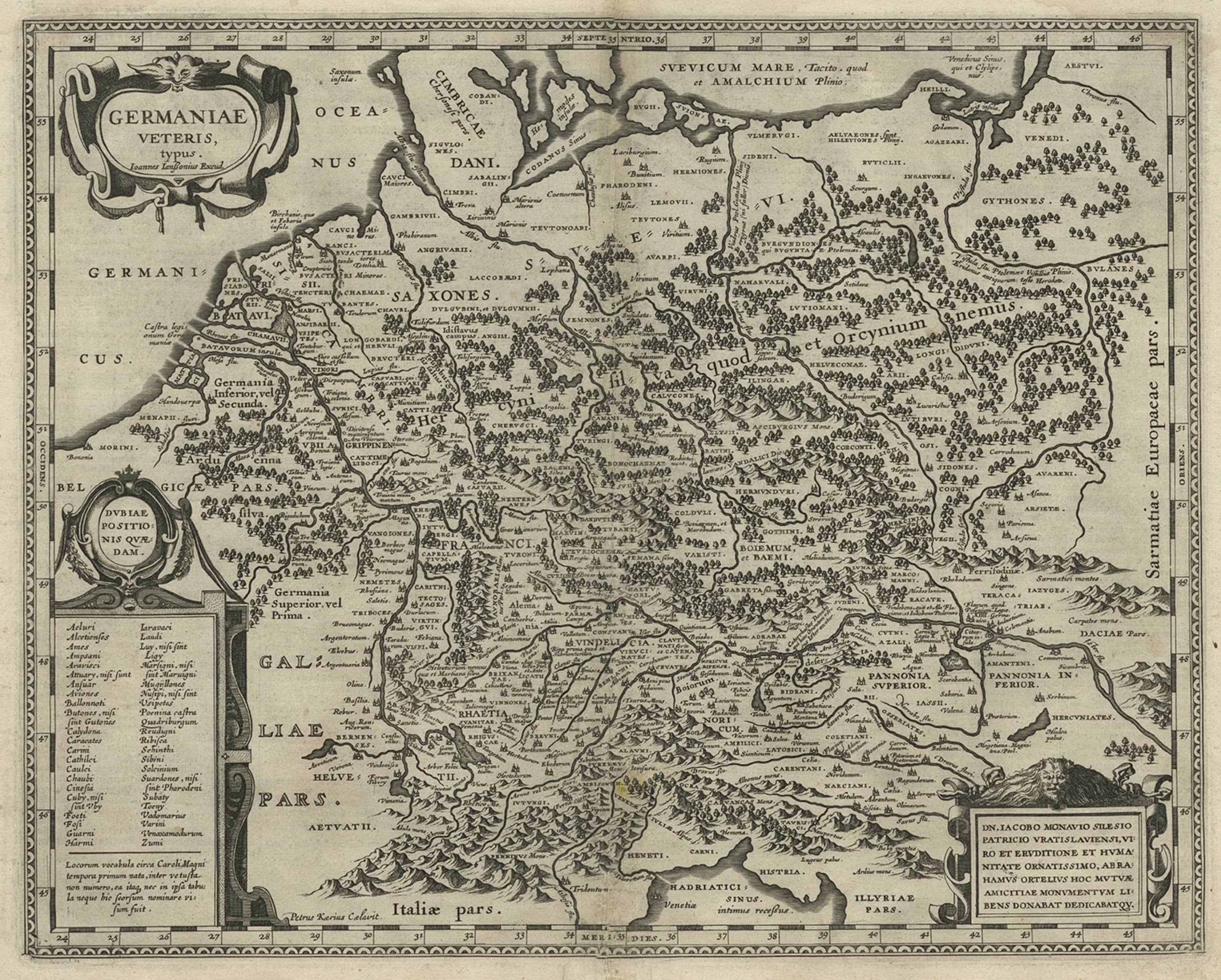
Antique Map of Germany of German in Roman Times, c.1660
Located in Langweer, NL
Antique map Germany titled 'Germaniae Veteris Typus'. Antique map probably by Blaeu or based on an earlier state by W. Blaeu.
Minor differences shown in the cartouches. Top left ha...
Category
Antique 17th Century Maps
Materials
Paper

$803 Sale Price
20% Off
Original Rare Antique Map of the Ancient German Empire in Northern Europe, c1650
Located in Langweer, NL
Antique map titled 'Germaniae Veteris typus.'
Map of the ancient German Empire in Northern Europe, based upon an earlier map by Ortelius. Extends fr...
Category
Antique 1650s Maps
Materials
Paper
$623 Sale Price
20% Off
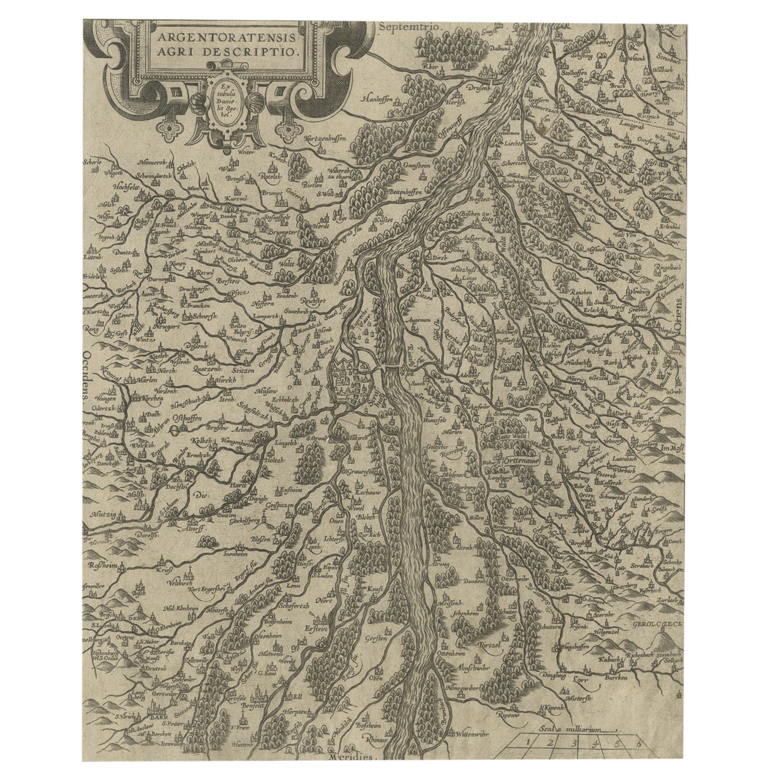
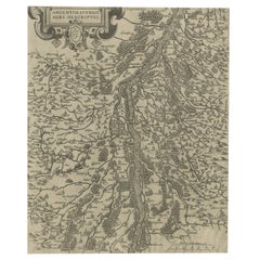
Original Antique Map of the Rhine, South and North of Strasbourg, Germany, 1608
Located in Langweer, NL
Antique map titled 'Argentoratensis agri descriptio'.
Original antique map of the Rhine, both south and north of Strasbourg, based on Daniel Specklin's three-sheet map of the Elz...
Category
Antique Early 1600s Maps
Materials
Paper
$302 Sale Price
20% Off
You May Also Like
17th Century Hand-Colored Map of a Region in West Germany by Janssonius
By Johannes Janssonius
Located in Alamo, CA
This attractive highly detailed 17th century original hand-colored map is entitled "Archiepiscopatus Maghdeburgensis et Anhaltinus Ducatus cum terris adjacentibus". It was published ...
Category
Antique Mid-17th Century Dutch Maps
Materials
Paper

Engraving Depicting 16th Century Map of Terra Sancta
Located in Buchanan, MI
Abraham Ortelius (Flemish, 1527-1598) Terra Sancta.
Engraving depicting 16th century map of Terra Sancta. Site 15" x 19.5.
Category
Antique 18th Century and Earlier Maps
Materials
Paper

Prussia, Poland, N. Germany, Etc: A Hand-colored 17th Century Map by Janssonius
By Johannes Janssonius
Located in Alamo, CA
This is an attractive hand-colored copperplate engraved 17th century map of Prussia entitled "Prussia Accurate Descripta a Gasparo Henneberg Erlichensi", published in Amsterdam by Joannes Janssonius in 1664. This very detailed map from the golden age of Dutch cartography includes present-day Poland, Latvia, Lithuania, Estonia and portions of Germany. This highly detailed map is embellished by three ornate pink, red, mint green and gold...
Category
Antique Mid-17th Century Dutch Maps
Materials
Paper

Original Antique Map of Switzerland, Engraved By Barlow, Dated 1807
Located in St Annes, Lancashire
Great map of Switzerland
Copper-plate engraving by Barlow
Published by Brightly & Kinnersly, Bungay, Suffolk.
Dated 1807
Unframed.
Category
Antique Early 1800s English Maps
Materials
Paper

17th Century Nicolas Visscher Map of Southeastern Europe
Located in Hamilton, Ontario
A beautiful, highly detailed map of southeastern Europe by Nicolas Visscher. Includes regions of Northern Italy (showing the cities Bologna, Padua, and Venice), Bohemia, Austria (sho...
Category
Antique 17th Century Dutch Maps
Materials
Paper

$1,350 Sale Price
38% Off
1592 Abraham Ortelius Map "Lorraine: Lotharingiae Nova Descripti, Ric.A005
Located in Norton, MA
1592 Abraham Ortelius map entitled
"Lorraine: Lotharingiae Nova Descripti
Ric.a005
Description: Ortelius is best known for producing the atlas from which this map comes from, "...
Category
Antique 16th Century Dutch Maps
Materials
Paper

More Ways To Browse
Bavaria Antique
Roman Inscription
German Renaissance Wood Furniture
Elios Chair
Plata Lappas
Red Retro Dining Set
Antique Bouquet
Antique Silver Glasses Case
Carlo Scarpa 1934 Chairs
Christofle Marly
1900 Antique Chairs
Glass Table Italian Round
Mid Century Colonial
Alvar Aalto Poster
Geometric Metal Table
Post Modern High Chairs
United Nations
Vintage Vine Rug