Items Similar to Eastern Texas Antique Map 1888 – Railroads, Counties & Settlements
Want more images or videos?
Request additional images or videos from the seller
1 of 10
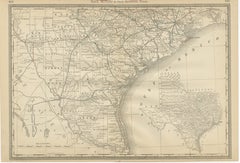
Eastern Texas Antique Map 1888 – Railroads, Counties & Settlements
$645.65
£477.44
€540
CA$893.48
A$994.83
CHF 517.69
MX$12,007.46
NOK 6,492.34
SEK 6,132.43
DKK 4,112.13
About the Item
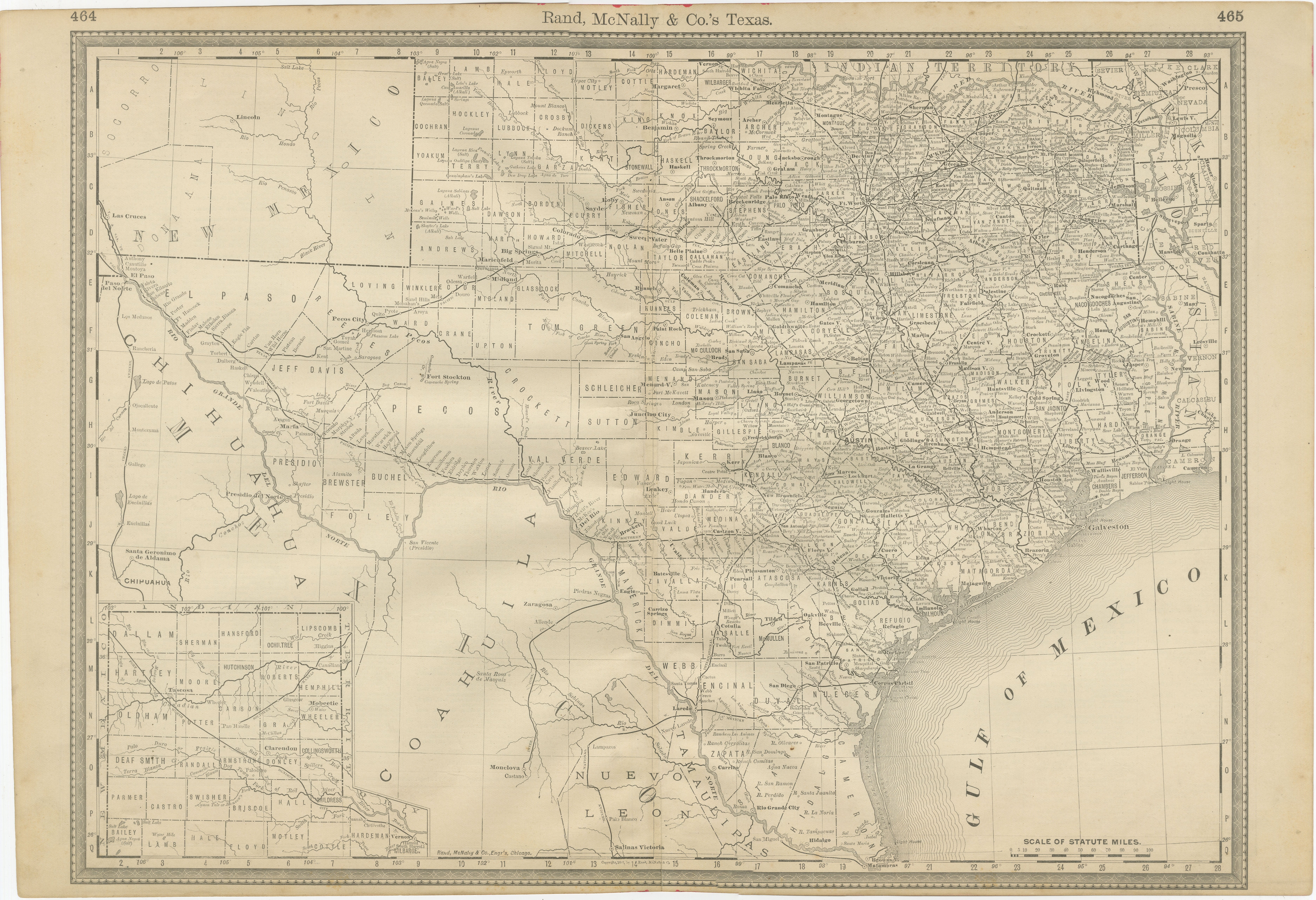
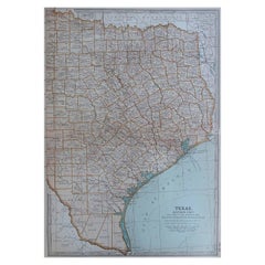
Eastern Texas Map 1888 – Rand McNally Antique Lithograph
This antique 1888 map of Eastern Texas, published by Rand, McNally & Co., provides a richly detailed depiction of one of the most economically and politically important regions of the state. Eastern Texas was the heart of cotton cultivation, cattle ranching, and railroad development during the late 19th century, and this map captures that significance with remarkable clarity.
Counties are finely engraved, including established ones such as Harris, Galveston, Jefferson, and Houston, alongside inland counties stretching westward into Erath, Brown, and Callahan. Major cities like Dallas, Houston, Galveston, Waco, and Austin stand out, reflecting their growing influence during this period. Countless smaller towns, railroad depots, and county seats are also shown, making this map an important genealogical and historical resource.
Railroads dominate the landscape, with red and blue lines marking the many competing lines that crisscrossed the region. The Houston & Texas Central, Missouri Pacific, Gulf, Colorado & Santa Fe, and International & Great Northern railroads are all represented, highlighting Eastern Texas as one of the most densely interconnected railroad regions in the South at the time. These railways facilitated the export of cotton through Galveston and Houston, while also linking Dallas and Fort Worth to the national economy.
Rivers, including the Trinity, Sabine, and Brazos, are carefully depicted, reinforcing the natural geography that shaped settlement and commerce. Eastern Texas’s proximity to Louisiana and Arkansas is also clear, situating the region as a cultural and economic crossroads between the Deep South and the western frontier.
This map reflects not only Rand, McNally & Co.’s cartographic precision but also the importance of Eastern Texas in shaping the broader history of the American South and West. It is an invaluable historical document for collectors of Texana, railroadiana, and maps of the Gulf South.
Condition: Very good, with light toning and foxing in margins. Plate mark visible. Minor edge wear consistent with age but paper remains strong with no significant tears or losses.
Framing tips: A dark wood or black frame with a cream mat will enhance the density of the railroad network and town names. For a more vibrant presentation, consider a double mat with a subtle red under-mat to highlight the rail lines.
Technique: Lithograph with printed detail
Maker: Rand, McNally & Co., Chicago, 1888
- Dimensions:Height: 14.18 in (36 cm)Width: 20.67 in (52.5 cm)Depth: 0.01 in (0.2 mm)
- Materials and Techniques:Paper,Engraved
- Place of Origin:
- Period:
- Date of Manufacture:1888
- Condition:Condition: Very good, with light toning and foxing in margins. Plate mark visible. Minor edge wear consistent with age but paper remains strong with no significant tears or losses.
- Seller Location:Langweer, NL
- Reference Number:Seller: BG-12794-461stDibs: LU3054346391222
About the Seller
5.0
Recognized Seller
These prestigious sellers are industry leaders and represent the highest echelon for item quality and design.
Platinum Seller
Premium sellers with a 4.7+ rating and 24-hour response times
Established in 2009
1stDibs seller since 2017
2,588 sales on 1stDibs
Typical response time: <1 hour
- ShippingRetrieving quote...Shipping from: Langweer, Netherlands
- Return Policy
Authenticity Guarantee
In the unlikely event there’s an issue with an item’s authenticity, contact us within 1 year for a full refund. DetailsMoney-Back Guarantee
If your item is not as described, is damaged in transit, or does not arrive, contact us within 7 days for a full refund. Details24-Hour Cancellation
You have a 24-hour grace period in which to reconsider your purchase, with no questions asked.Vetted Professional Sellers
Our world-class sellers must adhere to strict standards for service and quality, maintaining the integrity of our listings.Price-Match Guarantee
If you find that a seller listed the same item for a lower price elsewhere, we’ll match it.Trusted Global Delivery
Our best-in-class carrier network provides specialized shipping options worldwide, including custom delivery.More From This Seller
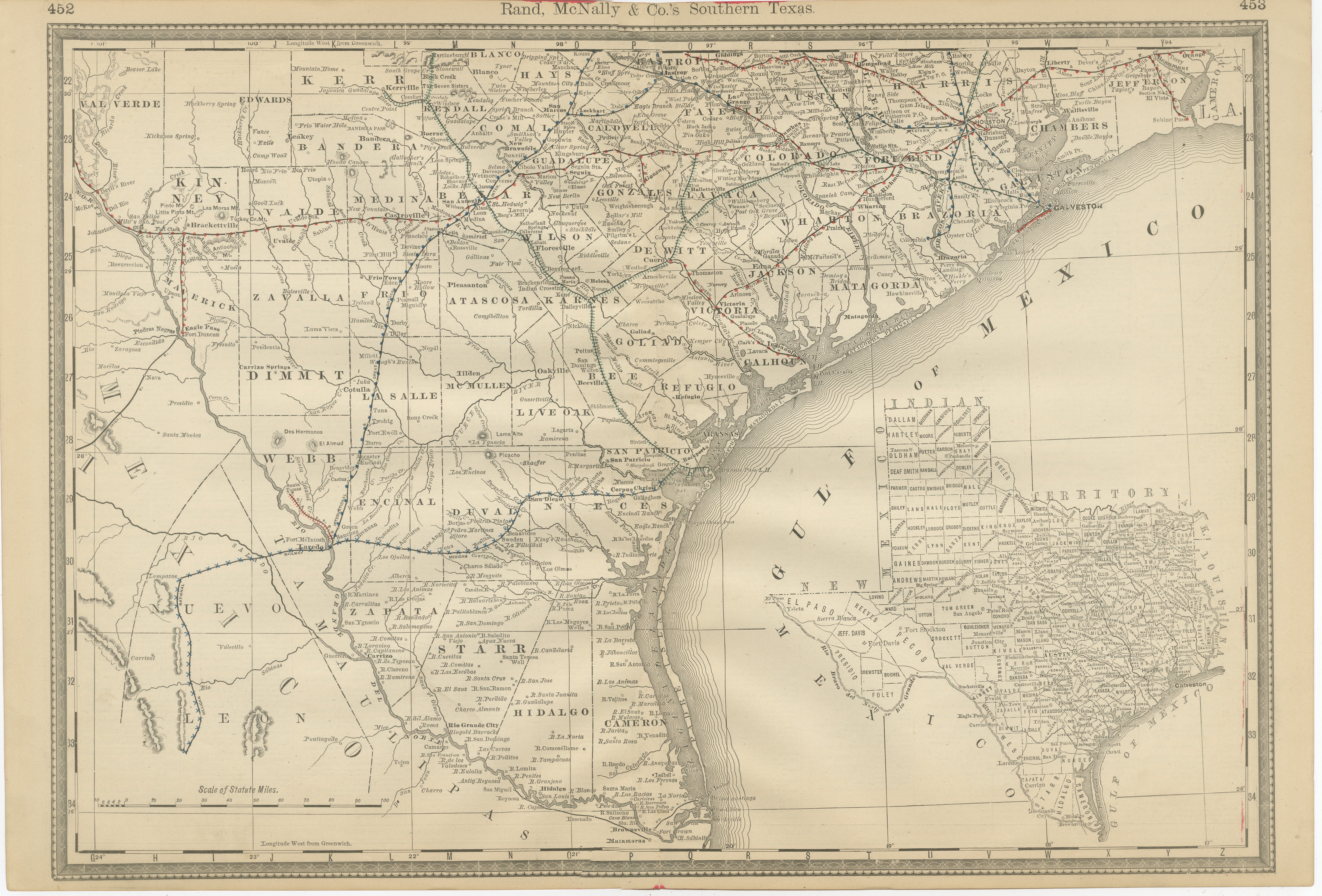
View AllAntique Map 1888 – Southern Texas Railroads, Counties & Settlements
Located in Langweer, NL
Southern Texas Map 1888 – Rand McNally Antique Lithograph
This antique 1888 map of Southern Texas, published by Rand, McNally & Co., depicts the Gulf Coast and borderlands with Mexi...
Category
Antique Late 19th Century American Maps
Materials
Paper
Texas Antique Map 1888 – Railroads, Counties & Frontier Settlements
Located in Langweer, NL
Texas Railroad Map 1888 – Rand McNally Antique Lithograph
This antique 1888 map of Texas, published by Rand, McNally & Co., provides a detailed overview of the state during a critic...
Category
Antique Late 19th Century American Maps
Materials
Paper

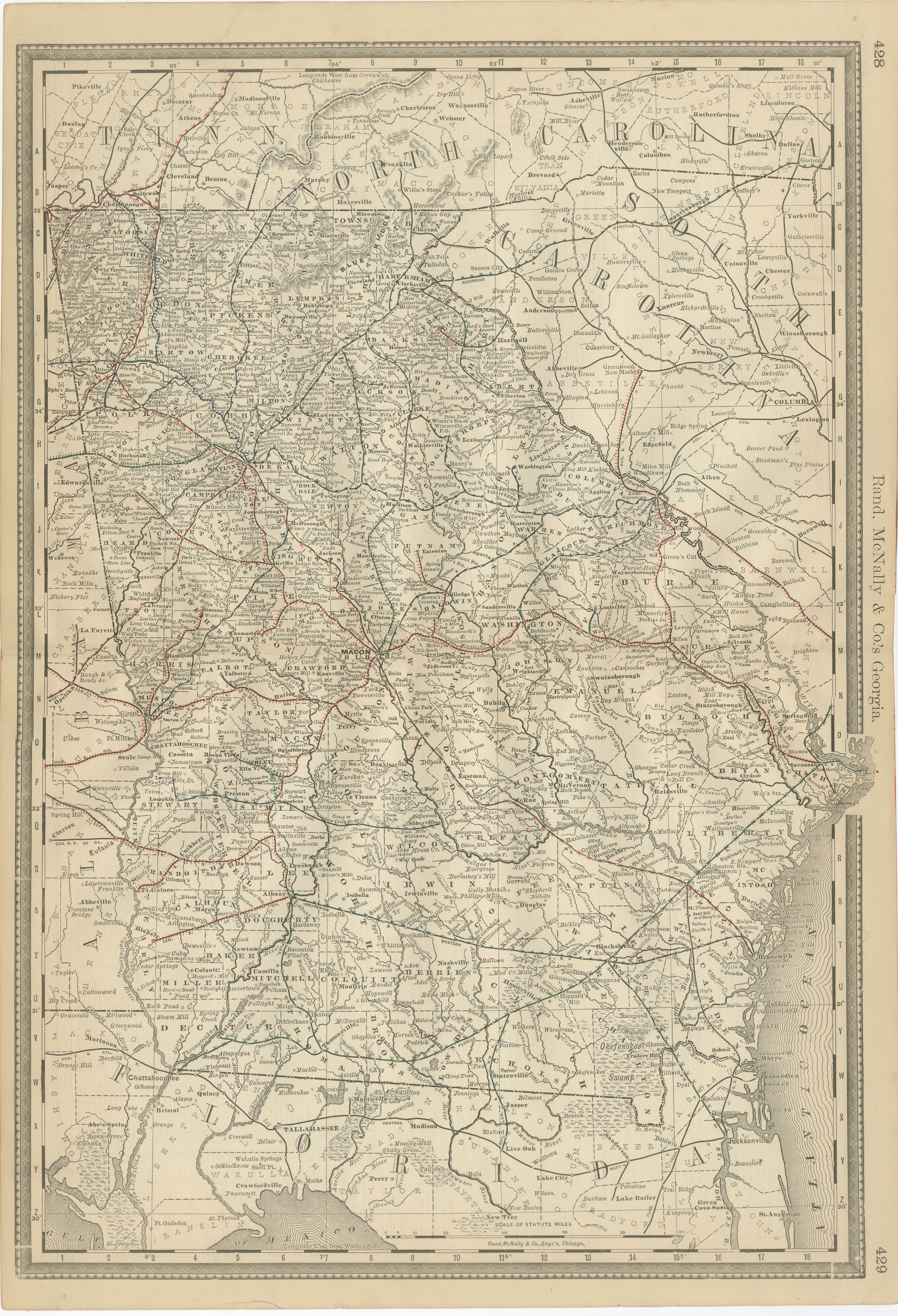
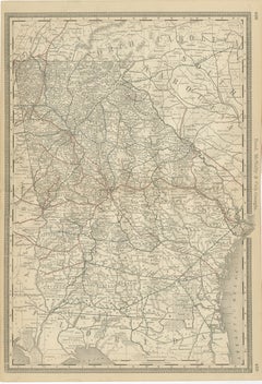
Georgia 1888 Antique Map – Railroads, Settlements & Frontier Counties
Located in Langweer, NL
Georgia Map 1888 – Rand McNally Antique Lithograph
This antique 1888 map of Georgia, published by Rand, McNally & Co., offers a detailed portrayal of the state in the post-Reconstru...
Category
Antique Late 19th Century American Maps
Materials
Paper
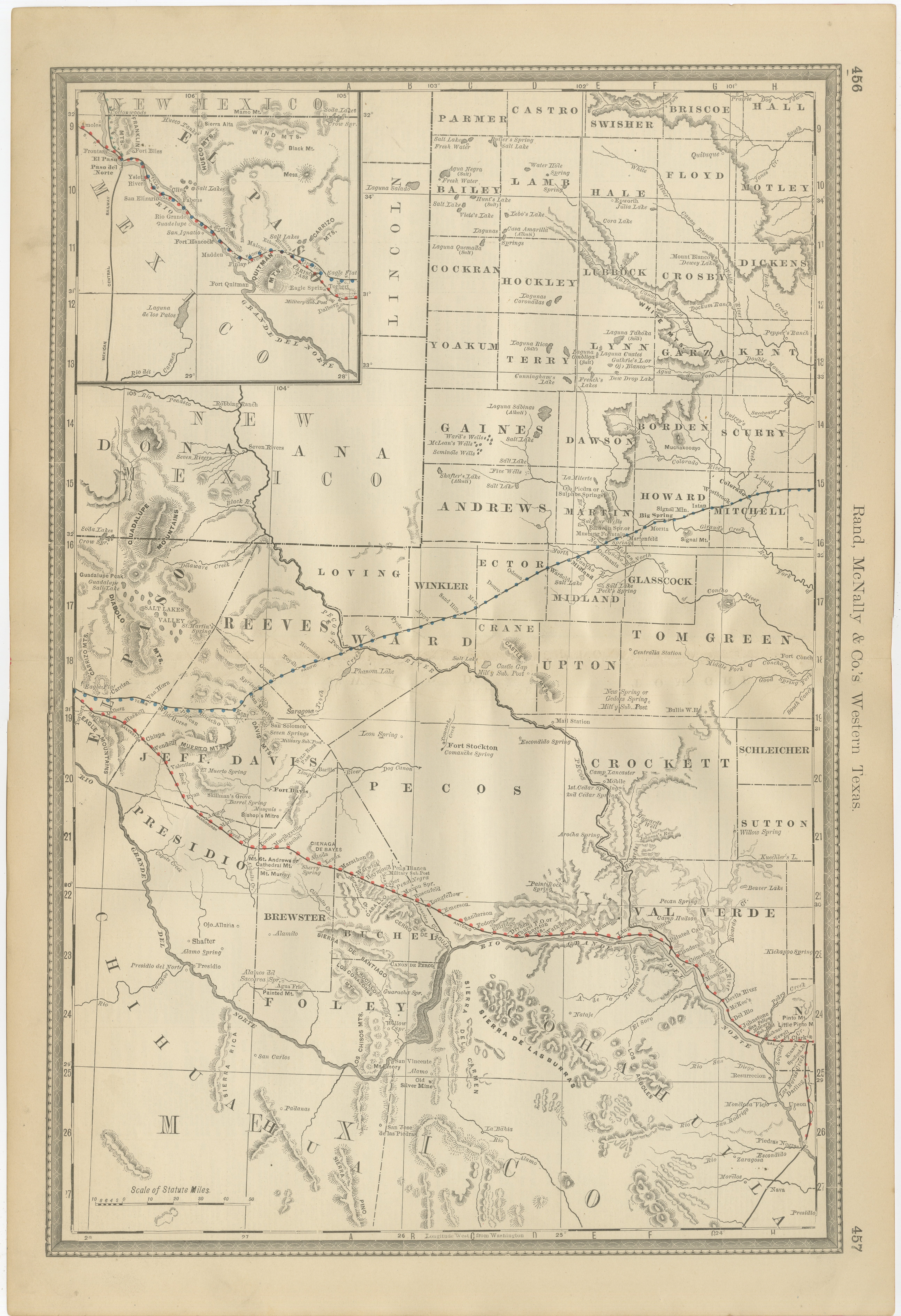
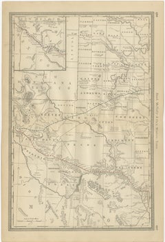
Western Texas Antique Map 1888 – Railroads, Counties & Frontier Towns
Located in Langweer, NL
Western Texas Map 1888 – Rand McNally Antique Lithograph
This antique 1888 map of Western Texas, published by Rand, McNally & Co., depicts the vast frontier counties of the region a...
Category
Antique Late 19th Century American Maps
Materials
Paper
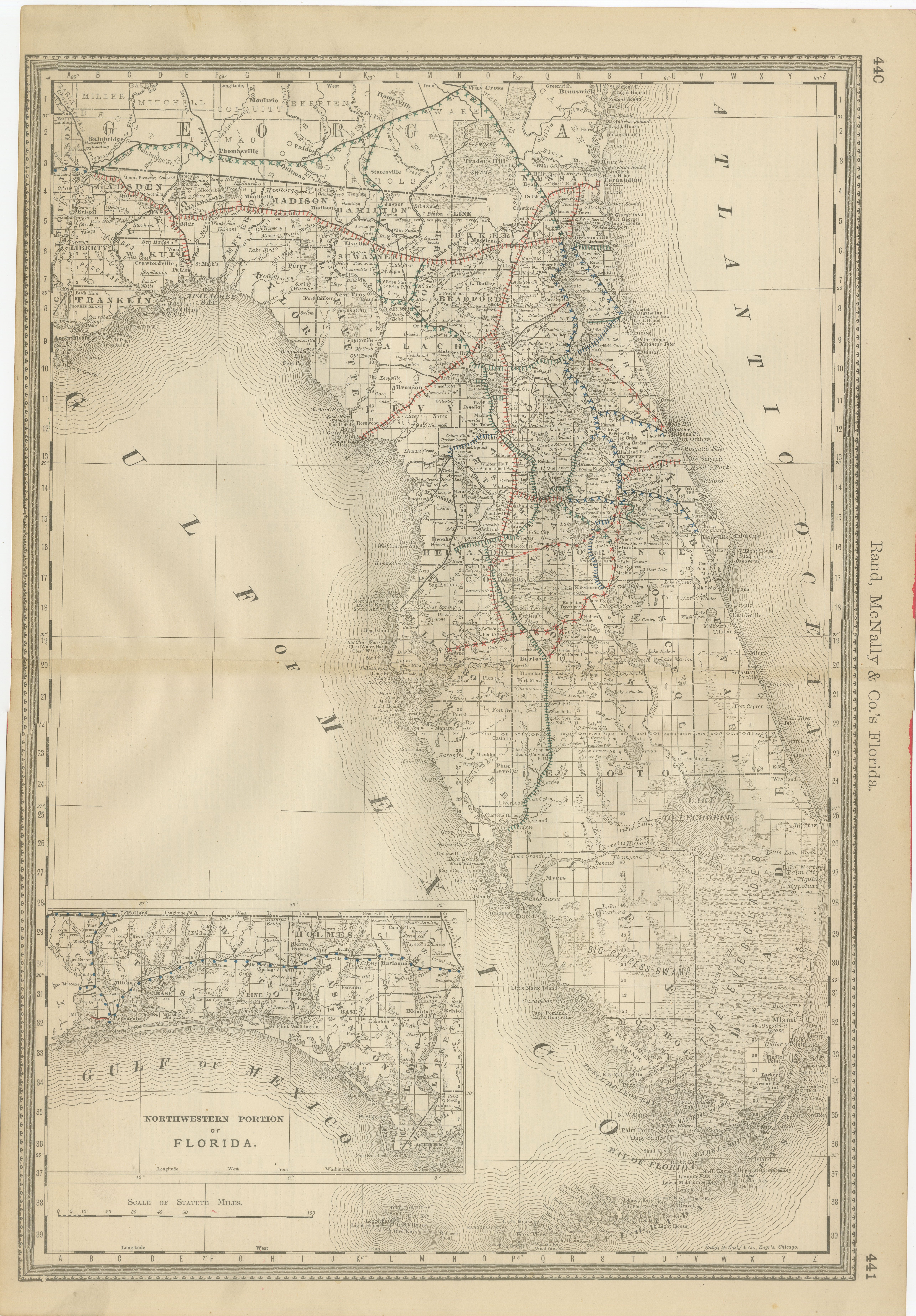
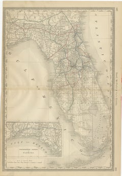
Florida 1888 Antique Map – Railroads, Settlements & Gulf Coast Detail
Located in Langweer, NL
Florida Map 1888 – Rand McNally Antique Lithograph
This antique 1888 map of Florida, published by Rand, McNally & Co., presents a detailed view of the state in the late 19th century...
Category
Antique Late 19th Century American Maps
Materials
Paper
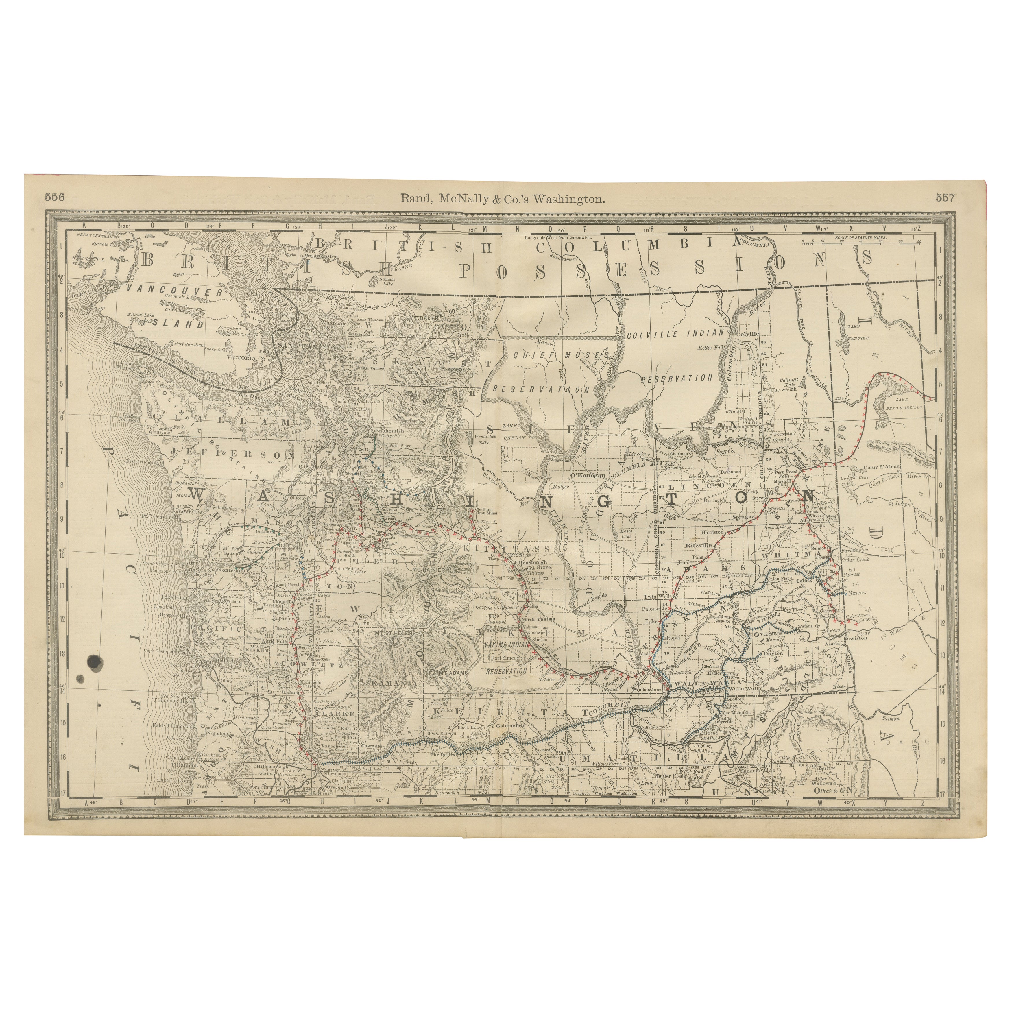
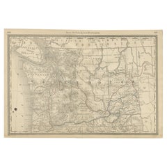
Washington Map 1888 – Antique Railroads, Indian Reservations & Counties
Located in Langweer, NL
Antique Map of Washington – Railroads, Counties & Indian Reservations, 1888
This original engraved map shows the Territory of Washington in 1888, a historically important moment jus...
Category
Antique Late 19th Century American Maps
Materials
Paper
You May Also Like
Original Antique Map of the American State of Texas ( Eastern Part ), 1903
Located in St Annes, Lancashire
Antique map of Texas ( Eastern part )
Published By A & C Black. 1903
Original colour
Good condition
Unframed.
Free shipping
Category
Antique Early 1900s English Maps
Materials
Paper
1899 Poole Brothers Antique Railroad Map of the Illinois Central Railroad
Located in Colorado Springs, CO
This is an 1899 railroad map of the Illinois Central and Yazoo and Mississippi Valley Railroads, published by the Poole Brothers. The map focuses on the continuous United States from the Atlantic to the Pacific Oceans, the Gulf of Mexico, and the Antilles. Remarkably detailed, the rail routes of the Illinois Central RR are marked in red, which each stop labeled. Major stops are overprinted in red, bold letters, with the short rail distances to New York listed above the stop and short rail distances to New Orleans listed below the name.
In addition to the Illinois Central network, numerous different rail lines are illustrated and the company running that line is noted along with many stops along each route. Sea routes from New Orleans to locations in Central America, the Caribbean, and Europe are marked and labeled with destination and distance, along with routes originating from Havana. Inset at bottom left is a map of Cuba; an inset map of Puerto Rico...
Category
Antique 1890s American Maps
Materials
Paper

Antique County Map, Buckinghamshire, Bedfordshire, Dutch, Framed, Janssonius
Located in Hele, Devon, GB
This is an antique county map of Buckinghamshire and Bedfordshire. A Dutch, framed atlas engraving by Johannes Janssonius, dating to the 17th century and later.
A treat for the col...
Category
Antique Mid-17th Century Dutch Maps
Materials
Paper

Original Antique English County Map, Herefordshire, J & C Walker, 1851
Located in St Annes, Lancashire
Great map of Herefordshire
Original colour
By J & C Walker
Published by Longman, Rees, Orme, Brown & Co. 1851
Unframed.
Category
Antique 1850s English Other Maps
Materials
Paper

Original Antique English County Map, Rutland, J & C Walker, 1851
Located in St Annes, Lancashire
Great map of Rutland
Original colour
By J & C Walker
Published by Longman, Rees, Orme, Brown & Co. 1851
Unframed.
Category
Antique 1850s English Other Maps
Materials
Paper

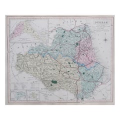
Original Antique English County Map, Durham, J & C Walker, 1851
Located in St Annes, Lancashire
Great map of Durham
Original colour
By J & C Walker
Published by Longman, Rees, Orme, Brown & Co. 1851
Unframed.
Category
Antique 1850s English Other Maps
Materials
Paper