Items Similar to Japanese Isles Map by Mallet, 1683 – Decorative Miniature Map

Video Loading
Want more images or videos?
Request additional images or videos from the seller
1 of 11
Japanese Isles Map by Mallet, 1683 – Decorative Miniature Map
$525.31
£387.41
€440
CA$726.06
A$807.43
CHF 423.79
MX$9,846.20
NOK 5,355.89
SEK 5,021.36
DKK 3,349.79
About the Item
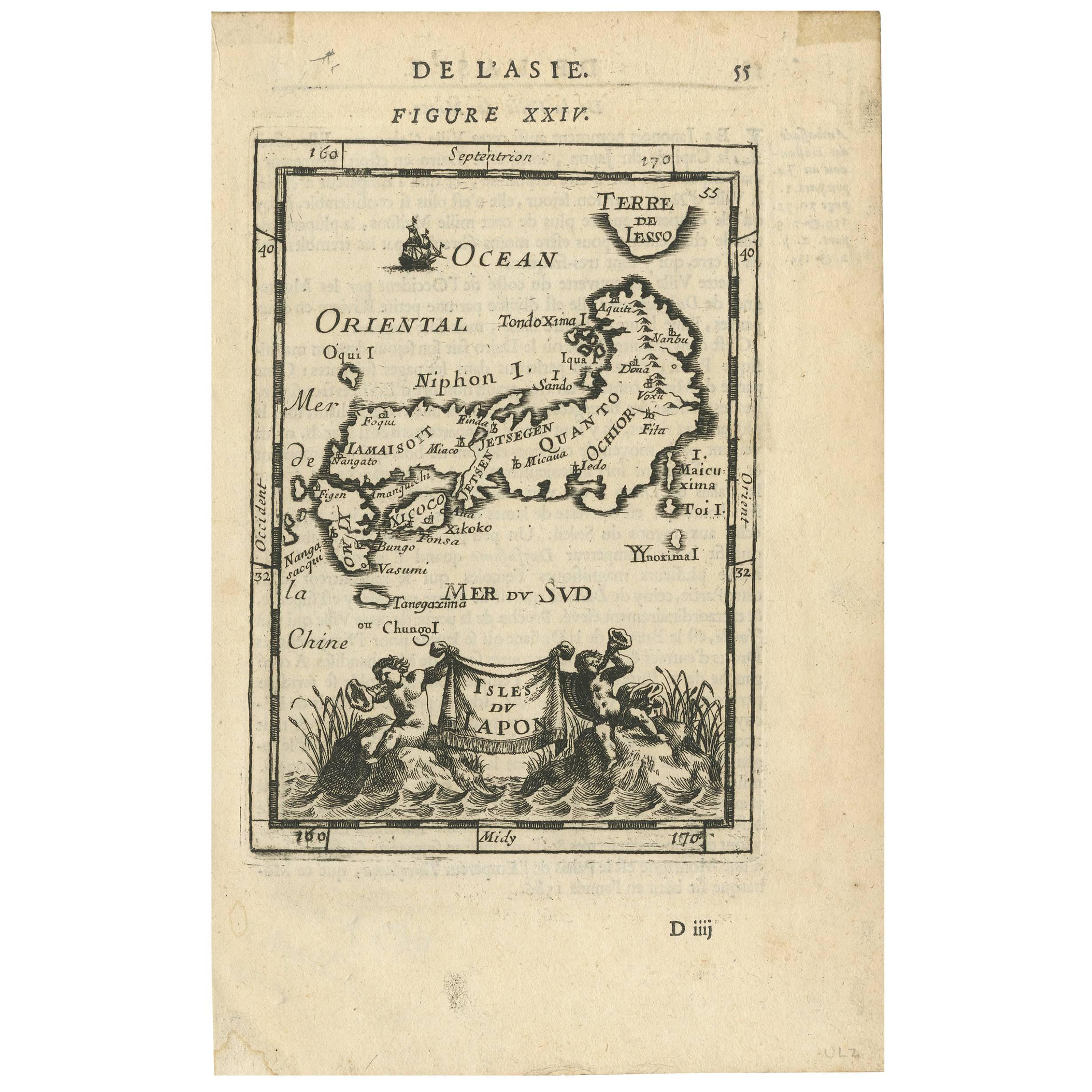
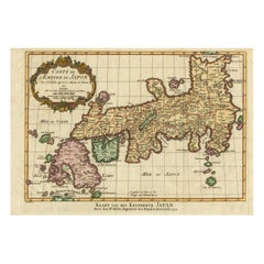
1683 Map of Japan Isles by Mallet – Decorative Miniature Map
This is an original antique map titled “Isles du Japon,” created by Alain Manesson Mallet and published in Paris in 1683. It was part of his renowned work Description de l’Univers, which comprised hundreds of maps and city views to illustrate the known world in a compact and accessible format for 17th-century readers.
The engraving depicts Japan, labelled as “Isles du Japon,” in a stylised and decorative manner typical of Mallet’s miniature cartography. The islands are shown with names such as Niphon, Xicoco, and Ieso (Hokkaido), reflecting European understanding of Japanese geography in the late 17th century based on limited Dutch and Jesuit sources. The seas surrounding the islands are named “Mer de la Chine,” “Mer du Sud,” and “Ocean Oriental,” and a small ship sails off the coast, enhancing its maritime charm.
At the bottom of the map is an attractive cartouche supported by two cherubs holding a banner inscribed “Isles du Japon,” with decorative plants and water waves, adding artistic appeal. This embellishment, along with the bright original hand colouring, makes the map highly decorative despite its small size.
Alain Manesson Mallet (1630–1706) was a French cartographer, engineer, and military teacher who worked under King Louis XIV. His maps are valued not only for their geographical content but also for their artistic engraving and elegant presentation, making them ideal for collectors of early Japanese maps, decorative cartography, and 17th-century European views of Asia.
Condition:
Very good condition. Strong impression with original hand colouring. Light age toning and faint spotting typical for antique paper, minor marginal marks away from the engraved area. No tears or restorations noted. Fully suitable for framing.
Framing tips:
Frame this miniature map with a wide off-white archival mat to emphasise its small size and fine detail. A slim gilt or dark wood frame will provide a classic presentation. UV-protective glass is recommended to preserve the vivid hand colouring and prevent fading over time.
- Dimensions:Height: 8.19 in (20.8 cm)Width: 5.32 in (13.5 cm)Depth: 0.01 in (0.2 mm)
- Materials and Techniques:Paper,Engraved
- Place of Origin:
- Period:1680-1689
- Date of Manufacture:1683
- Condition:Very good condition. Strong impression with original hand colouring. Light age toning and faint spotting typical for antique paper, minor marginal marks away from the engraved area. No tears or restorations noted. Fully suitable for framing.
- Seller Location:Langweer, NL
- Reference Number:Seller: BGSH-0051stDibs: LU3054345663822
About the Seller
5.0
Recognized Seller
These prestigious sellers are industry leaders and represent the highest echelon for item quality and design.
Platinum Seller
Premium sellers with a 4.7+ rating and 24-hour response times
Established in 2009
1stDibs seller since 2017
2,577 sales on 1stDibs
Typical response time: <1 hour
- ShippingRetrieving quote...Shipping from: Langweer, Netherlands
- Return Policy
Authenticity Guarantee
In the unlikely event there’s an issue with an item’s authenticity, contact us within 1 year for a full refund. DetailsMoney-Back Guarantee
If your item is not as described, is damaged in transit, or does not arrive, contact us within 7 days for a full refund. Details24-Hour Cancellation
You have a 24-hour grace period in which to reconsider your purchase, with no questions asked.Vetted Professional Sellers
Our world-class sellers must adhere to strict standards for service and quality, maintaining the integrity of our listings.Price-Match Guarantee
If you find that a seller listed the same item for a lower price elsewhere, we’ll match it.Trusted Global Delivery
Our best-in-class carrier network provides specialized shipping options worldwide, including custom delivery.More From This Seller
View AllAntique Map of Japan and Korea by Sanson, 'c.1690'
Located in Langweer, NL
Antique map titled 'Les Iles du Iapon (..)'. Original antique map, with beautiful (later) hand coloring, of Japan and the Island of Corey (Korea). Uncommon edition, with '234' at top...
Category
Antique Late 17th Century Maps
Materials
Paper

$955 Sale Price
20% Off
Antique Map of the Region of Osaka and Hirado Island in Japan, 1725
By Pieter Van Der Aa
Located in Langweer, NL
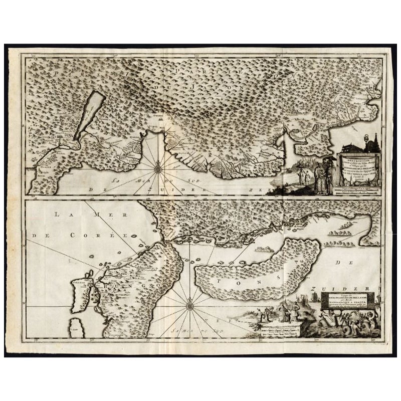
Antique map titled 'Description exacte et fidele des villes, bourgs et villages qui les Ambassadeurs de Hollande ont rencontrez dans leur voyage par terre de la ville Osacca jusqu'a ...
Category
Antique 18th Century Maps
Materials
Paper
$1,265 Sale Price
20% Off
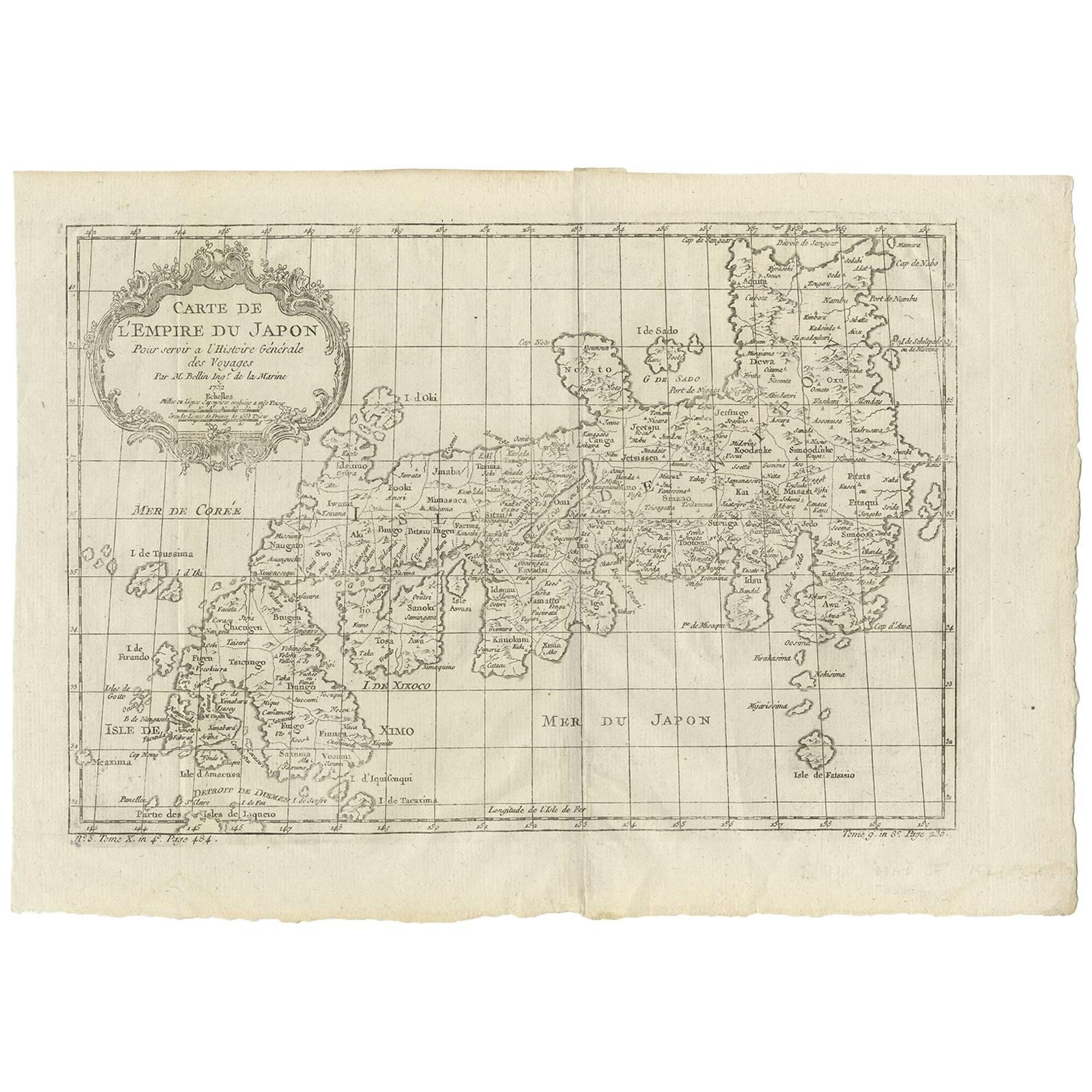
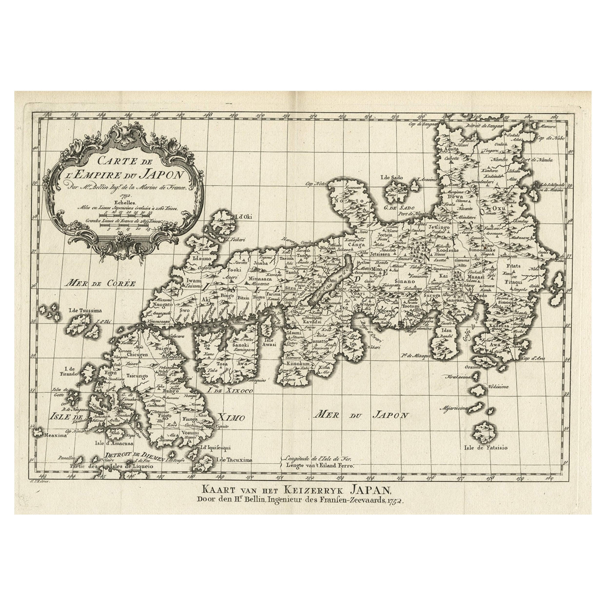
Nice Antique Map of the Empire of Japan. Centered on the Bay of Osaka, ca.1752
Located in Langweer, NL
Antique map titled 'Carte de L'Empire de Japon (..).'
Map of the Empire of Japan. Centered on the Bay of Osaka, this map covers from Hirado (here identified as I. Firando) and Naga...
Category
Antique 1750s Maps
Materials
Paper
$907 Sale Price
20% Off
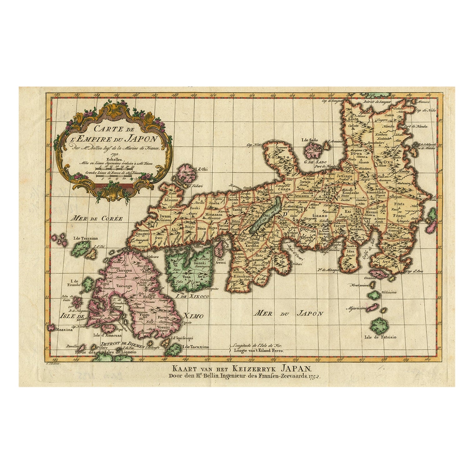
Antique Map of Japan by J.N. Bellin, 1752
Located in Langweer, NL
Bellin's wonderfully detailed map of Japan from the atlas of Prevost d'Exiles' influential collection of travel narratives, Histoire Generale des Voyages. Considered the best general...
Category
Antique Mid-18th Century Maps
Materials
Paper

$439 Sale Price
20% Off
Antique Map of Japan by A.M. Mallet, 1683
Located in Langweer, NL
A charming late 17th century French map with a very decorative title cartouche showing trumpet-blowing cherubs, by Allain Manneson Mallet (1630-1706), a well traveled military engine...
Category
Antique Late 17th Century French Maps
Materials
Paper

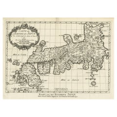
Original Antique Map of the Empire of Japan, Centered on the Bay of Osaka, c1752
Located in Langweer, NL
Antique map titled 'Carte de L'Empire de Japon (..).'
Map of the Empire of Japan. Centered on the Bay of Osaka, this map covers from Hirado (here identified as I. Firando) and Na...
Category
Antique 1750s Maps
Materials
Paper
$802 Sale Price
20% Off
You May Also Like
Ancient Map - Zeilan - Etching by Johannes Janssonius - 1650s
By Johannes Janssonius
Located in Roma, IT
Ancient Map - Zeilan is an ancient map realized in 1650 by Johannes Janssonius (1588-1664).
The Map is Hand-colored etching, with coeval watercoloring.
...
Category
1650s Modern Figurative Prints
Materials
Etching

Antique French Map of Asia Including China Indoneseia India, 1783
Located in Amsterdam, Noord Holland
Very nice map of Asia. 1783 Dedie au Roy.
Additional information:
Country of Manufacturing: Europe
Period: 18th century Qing (1661 - 1912)
Condition: Overall Condition B (Good Used)...
Category
Antique 18th Century European Maps
Materials
Paper

$648 Sale Price
20% Off
Antique Map - Mare Pacificum - Etching by Johannes Janssonius - 1650s
By Johannes Janssonius
Located in Roma, IT
Mare Pacificum is an antique map realized in 1650 by Johannes Janssonius (1588-1664).
The Map is Hand-colored etching, with coeval watercolorang.
Good conditions with slight foxing...
Category
1650s Modern Figurative Prints
Materials
Etching

Asia Declineatio: A 17th Century Hand-colored Map of Asia by Justus Danckerts
Located in Alamo, CA
This is a scarce 17th century beautifully hand-colored copperplate engraved map of Asia entitled “Exactissima Asiae Delineatio in Praecipuas Regiones Caerterasque Partes divisa et de...
Category
Late 17th Century Old Masters Landscape Prints
Materials
Engraving

Antique Map - Mar Di Athiopia - Etching by Johannes Janssonius - 1650s
By Johannes Janssonius
Located in Roma, IT
Antique Map - Mar Di Athiopia is an antique map realized in 1650 by Johannes Janssonius (1588-1664).
The Map is Hand-colored etching, with coeval watercolorang.
Good conditions wit...
Category
1650s Modern Figurative Prints
Materials
Etching

West Africa: A 17th Century Hand-Colored Map by Mercator/Hondius
By Gerard Mercator
Located in Alamo, CA
A 17th century hand-colored map entitled "Guineae Nova Descriptio" by Gerard Mercator and Jodocus Hondius, published in their 'Atlas Minor' in Amsterdam in 1635. It is focused on the...
Category
1630s Landscape Prints
Materials
Engraving

More Ways To Browse
Japan Antiques Collectables
King Louis Xiv
Antique French Miniature
Cherub Charm
Dutch Military
Japanese Compact
17th Century Dutch Wood Frames
Engraving Louis Xiv
Curved Velvet Couch
Velvet Curved Sofa
Wood Round Coffee Tables
Oak Brutalist
Used College Furniture
Wood Minimalist Chair
Antique Imperial Furniture
Gold Modern Coffee Table
Large Side Tables
18th Century Gilded Furniture