Items Similar to Large Original Antique Map of Alaska, USA, C.1900


Want more images or videos?
Request additional images or videos from the seller
1 of 5
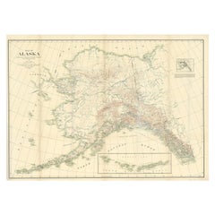
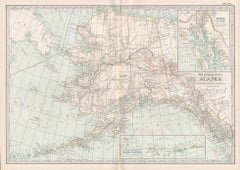
Large Original Antique Map of Alaska, USA, C.1900
$50
£37.96
€43.42
CA$69.86
A$77.70
CHF 40.57
MX$945.48
NOK 518.15
SEK 485.93
DKK 324.04
Shipping
Retrieving quote...The 1stDibs Promise:
Authenticity Guarantee,
Money-Back Guarantee,
24-Hour Cancellation
About the Item
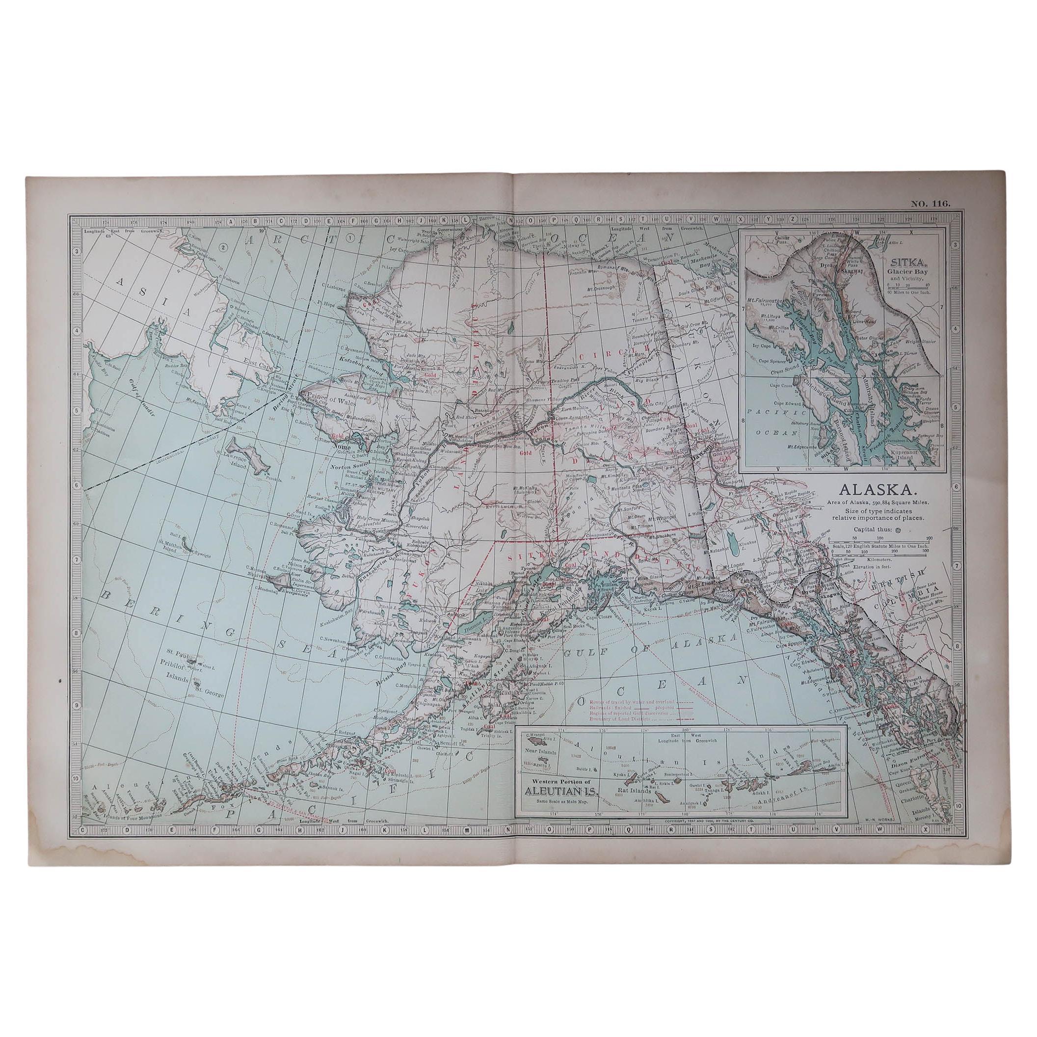
Fabulous map of Alaska
Original color
Engraved and printed by the George F. Cram Company, Indianapolis.
Published, C.1900
Unframed
Free shipping.
- Dimensions:Height: 22 in (55.88 cm)Width: 15 in (38.1 cm)Depth: 0.07 in (1.78 mm)
- Materials and Techniques:Paper,Other
- Place of Origin:
- Period:
- Date of Manufacture:1900
- Condition:Wear consistent with age and use.
- Seller Location:St Annes, GB
- Reference Number:1stDibs: LU1836332469912
About the Seller
4.9
Platinum Seller
Premium sellers with a 4.7+ rating and 24-hour response times
1stDibs seller since 2016
3,114 sales on 1stDibs
Typical response time: 1 hour
Associations
International Confederation of Art and Antique Dealers' Associations
- ShippingRetrieving quote...Shipping from: St Annes, United Kingdom
- Return Policy
Authenticity Guarantee
In the unlikely event there’s an issue with an item’s authenticity, contact us within 1 year for a full refund. DetailsMoney-Back Guarantee
If your item is not as described, is damaged in transit, or does not arrive, contact us within 7 days for a full refund. Details24-Hour Cancellation
You have a 24-hour grace period in which to reconsider your purchase, with no questions asked.Vetted Professional Sellers
Our world-class sellers must adhere to strict standards for service and quality, maintaining the integrity of our listings.Price-Match Guarantee
If you find that a seller listed the same item for a lower price elsewhere, we’ll match it.Trusted Global Delivery
Our best-in-class carrier network provides specialized shipping options worldwide, including custom delivery.More From This Seller
View AllOriginal Antique Map of the American State of Alaska, 1903
Located in St Annes, Lancashire
Antique map of Alaska
Published By A & C Black. 1903
Original colour
Good condition
Unframed.
Free shipping
Category
Antique Early 1900s English Maps
Materials
Paper

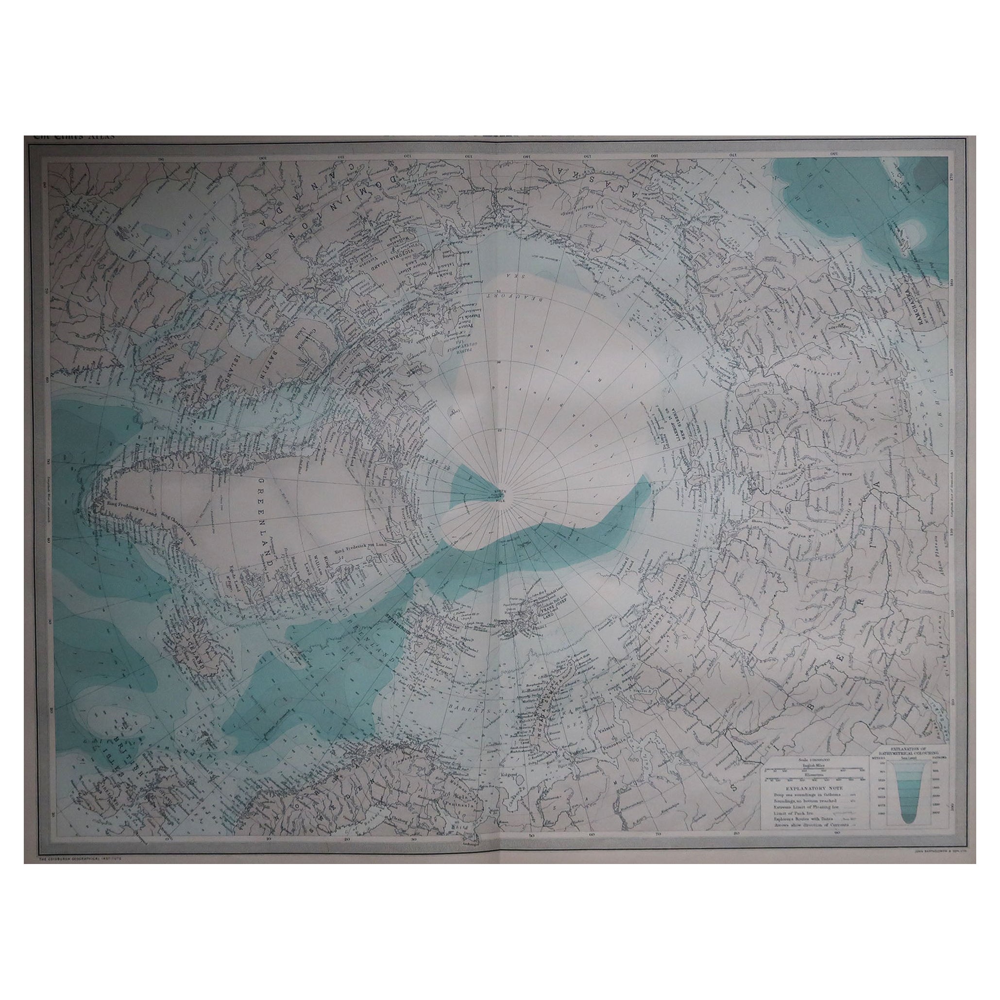
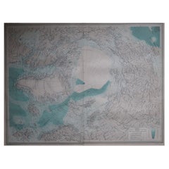
Large Original Vintage Map of The North Pole, circa 1920
Located in St Annes, Lancashire
Great maps of The North Pole.
Unframed.
Original color.
By John Bartholomew and Co. Edinburgh Geographical Institute.
Published, circa 1920.
Free shipp...
Category
Vintage 1920s British Maps
Materials
Paper
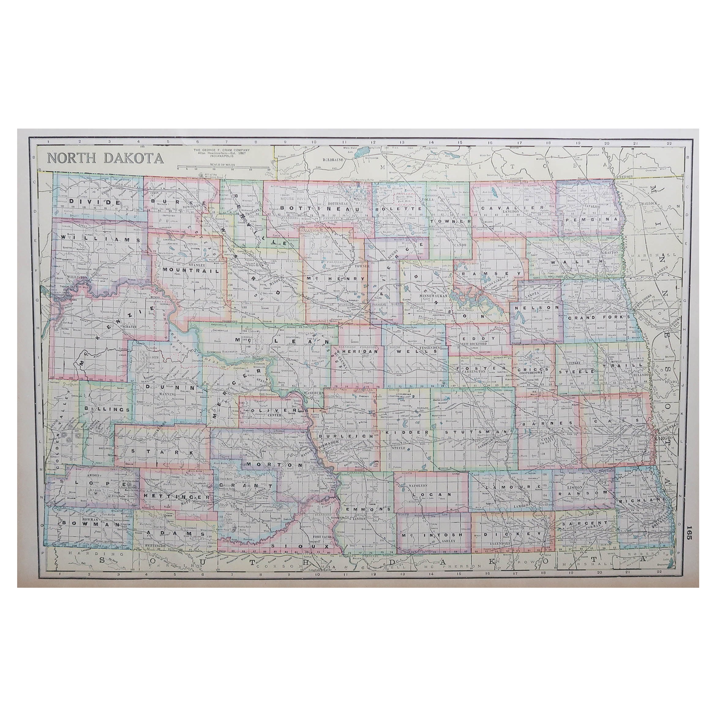
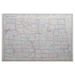
Large Original Antique Map of North Dakota, USA, circa 1900
Located in St Annes, Lancashire
Fabulous map of North Dakota
Original color
Engraved and printed by the George F. Cram Company, Indianapolis.
Published, circa 1900
Unframed
Free shi...
Category
Antique 1890s American Maps
Materials
Paper
Original Antique Map of the American State of Washington, 1903
Located in St Annes, Lancashire
Antique map of Washington
Published By A & C Black. 1903
Original colour
Good condition
Unframed.
Free shipping
Category
Antique Early 1900s English Maps
Materials
Paper

Large Original Vintage Map of North America, circa 1920
Located in St Annes, Lancashire
Great map of North America
Original color. Good condition
Published by Alexander Gross
Unframed.
Category
Vintage 1920s English Edwardian Maps
Materials
Paper

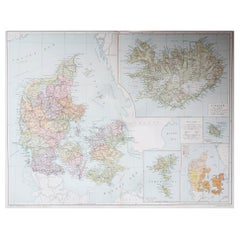
Large Original Vintage Map of Iceland, circa 1920
Located in St Annes, Lancashire
Great map of Iceland
Original color. Good condition
Published by Alexander Gross
Unframed.
Category
Vintage 1920s English Victorian Maps
Materials
Paper
You May Also Like
Antique Map of Alaska '1904'
Located in Langweer, NL
An antique map titled 'Map of Alaska Compiled Under the Direction of R.U. Goode, Geographer,' which relies on data from both the U.S. Geological Survey a...
Category
Early 20th Century Maps
Materials
Paper
$575 Sale Price
20% Off
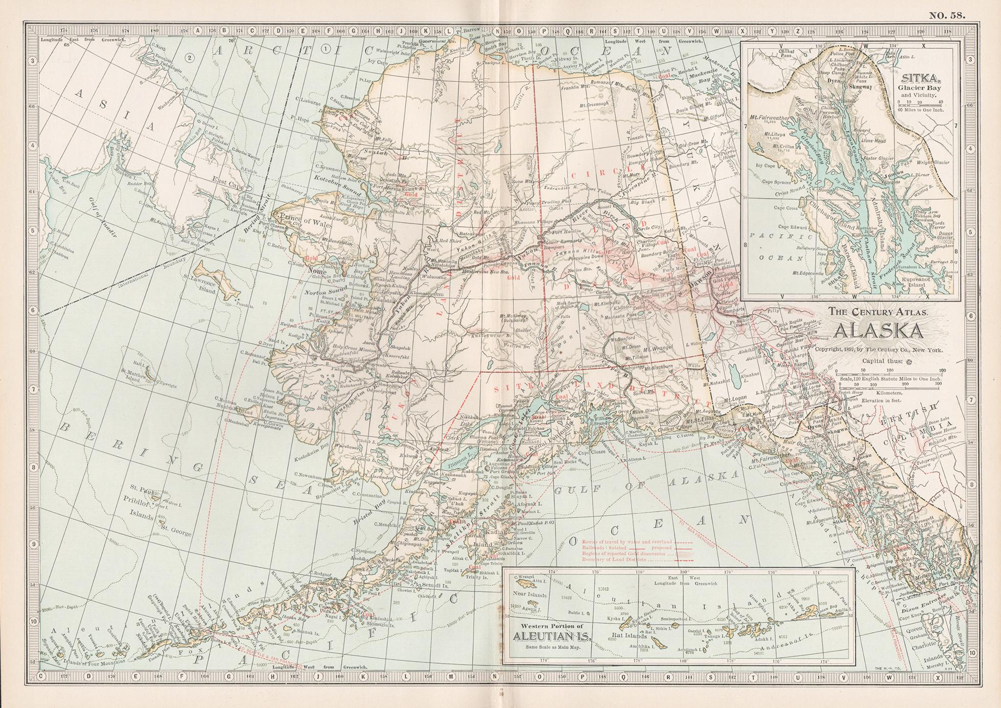
Alaska, United States of America, Century Atlas state antique vintage map
Located in Melbourne, Victoria
'The Century Atlas. Alaska.' Inset maps of 'Sitka, Glacier Bay' and Aleutian Is.'.
Original antique map, 1903.
Central fold as issued. Map name and number printed on the reverse cor...
Category
Early 20th Century Victorian More Prints
Materials
Lithograph

Alaska, North America. Century Atlas antique vintage map
Located in Melbourne, Victoria
'The Century Atlas. Alaska, North America.'
Original antique map, 1903.
Inset maps of 'Sitka, Glacier Bay' and Aleutian Is.'.
Central fold as issued. Map name and number printed on...
Category
Early 20th Century Victorian More Prints
Materials
Lithograph
Antique Map of the Arctic Regions by Lowry '1852'
Located in Langweer, NL
Antique map titled 'Arctic Regions'. Original map of the Arctic Regions. This map originates from 'Lowry's Table Atlas constructed and engraved from the most recent Authorities' by J...
Category
Antique Mid-19th Century Maps
Materials
Paper

$95 Sale Price
20% Off
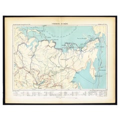
Antique Map of Siberia by Reclus, 1881
Located in Langweer, NL
Antique map titled 'Itineraires en Siberie.' This map shows the itineraries of famous explorers in Siberia between 1648 and 1879. This original old antique print / plate originates f...
Category
Antique 19th Century Maps
Materials
Paper
19th-Century Decorative Map of British America with Arctic and Pacific Vignettes
Located in Langweer, NL
19th-Century Decorative Map of British America with Arctic and Pacific Vignettes
This 19th-century map of British America, drawn and engraved by J. Rapkin and published by J & F T...
Category
Antique 1850s Maps
Materials
Paper

More Ways To Browse
Used Furniture Indianapolis
J And C Bavaria
Map Of Barbados
Montreal Map
Antique Furniture Toledo Ohio
Laos Antique Map
Orinoco Furniture
Johann Baptist Homann On Sale
Rand Mcnally Vintage Maps
Tipu Sultan
Antique Map Bermuda
Antique Map Holder
Lancashire Map
Maltese Falcon
Raised Relief Map
William Dampier
Antique Chesapeake Bay Map
Astrology Map