Items Similar to Louisiana Antique Map 1888 – The Pelican State, Railroads & Counties

Want more images or videos?
Request additional images or videos from the seller
1 of 10
Louisiana Antique Map 1888 – The Pelican State, Railroads & Counties
$550
£406.71
€460
CA$761.11
A$847.45
CHF 441
MX$10,228.58
NOK 5,530.51
SEK 5,223.92
DKK 3,502.92
About the Item
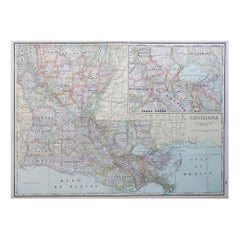
Louisiana Map 1888 – Rand McNally Antique Lithograph
This antique 1888 map of Louisiana, published by Rand, McNally & Co., provides a richly detailed picture of the state in the late 19th century. The map captures Louisiana during a period of recovery and modernization after the Civil War, when agriculture, commerce along the Mississippi River, and expanding railroads defined its economy and society.
All parishes are clearly engraved, with parish seats and smaller towns labeled throughout. The map emphasizes the state’s unique geography, including the Mississippi River and its delta, the Atchafalaya Basin, and the intricate network of bayous, lakes, and wetlands that define southern Louisiana. New Orleans, Baton Rouge, and Shreveport stand out as major centers of trade and industry, while numerous smaller communities appear across the fertile parishes of the river corridor and Gulf Coast.
Railroads are prominently shown in red and blue, reflecting their growing importance in connecting Louisiana’s agricultural interior with national markets. Lines such as the Texas & Pacific, New Orleans Pacific, and Louisville & Nashville appear, illustrating how railroads supplemented the traditional river trade while also reshaping settlement patterns. The port of New Orleans remains central, serving as a major gateway for cotton, sugar, and lumber exports through the Gulf of Mexico.
The map also depicts Louisiana’s borders with Texas, Mississippi, and Arkansas, situating the state as a crossroads of the Gulf South. Natural features such as the Red River, Lake Pontchartrain, and the coastal marshlands are carefully engraved, highlighting the challenges and opportunities of the landscape.
As with all Rand, McNally maps of this era, the engraving is precise and practical, designed for both reference and historical record. Today, the map serves as a valuable artifact for understanding Louisiana’s development at a pivotal time in its history.
Condition: Very good, with light toning and foxing in margins. Plate mark visible. Central fold as issued. Paper strong with no tears or losses.
Framing tips: A walnut or black frame with a cream mat will highlight the coastal details and parish divisions. A subtle blue or grey secondary mat could enhance the Gulf of Mexico and waterways.
Technique: Lithograph with printed detail
Maker: Rand, McNally & Co., Chicago, 1888
Special note: Maps of Louisiana from the late 19th century are particularly desirable among collectors, as they capture the state’s distinctive geography, the importance of the Mississippi River trade, and the emergence of the railroad network that shaped its modern economy.
- Dimensions:Height: 14.18 in (36 cm)Width: 20.67 in (52.5 cm)Depth: 0.01 in (0.2 mm)
- Materials and Techniques:Paper,Engraved
- Place of Origin:
- Period:
- Date of Manufacture:1888
- Condition:Condition: Very good, with light toning and foxing in margins. Plate mark visible. Central fold as issued. Paper strong with no tears or losses.
- Seller Location:Langweer, NL
- Reference Number:Seller: BG-12794-411stDibs: LU3054346391382
About the Seller
5.0
Recognized Seller
These prestigious sellers are industry leaders and represent the highest echelon for item quality and design.
Platinum Seller
Premium sellers with a 4.7+ rating and 24-hour response times
Established in 2009
1stDibs seller since 2017
2,587 sales on 1stDibs
Typical response time: <1 hour
- ShippingRetrieving quote...Shipping from: Langweer, Netherlands
- Return Policy
Authenticity Guarantee
In the unlikely event there’s an issue with an item’s authenticity, contact us within 1 year for a full refund. DetailsMoney-Back Guarantee
If your item is not as described, is damaged in transit, or does not arrive, contact us within 7 days for a full refund. Details24-Hour Cancellation
You have a 24-hour grace period in which to reconsider your purchase, with no questions asked.Vetted Professional Sellers
Our world-class sellers must adhere to strict standards for service and quality, maintaining the integrity of our listings.Price-Match Guarantee
If you find that a seller listed the same item for a lower price elsewhere, we’ll match it.Trusted Global Delivery
Our best-in-class carrier network provides specialized shipping options worldwide, including custom delivery.More From This Seller
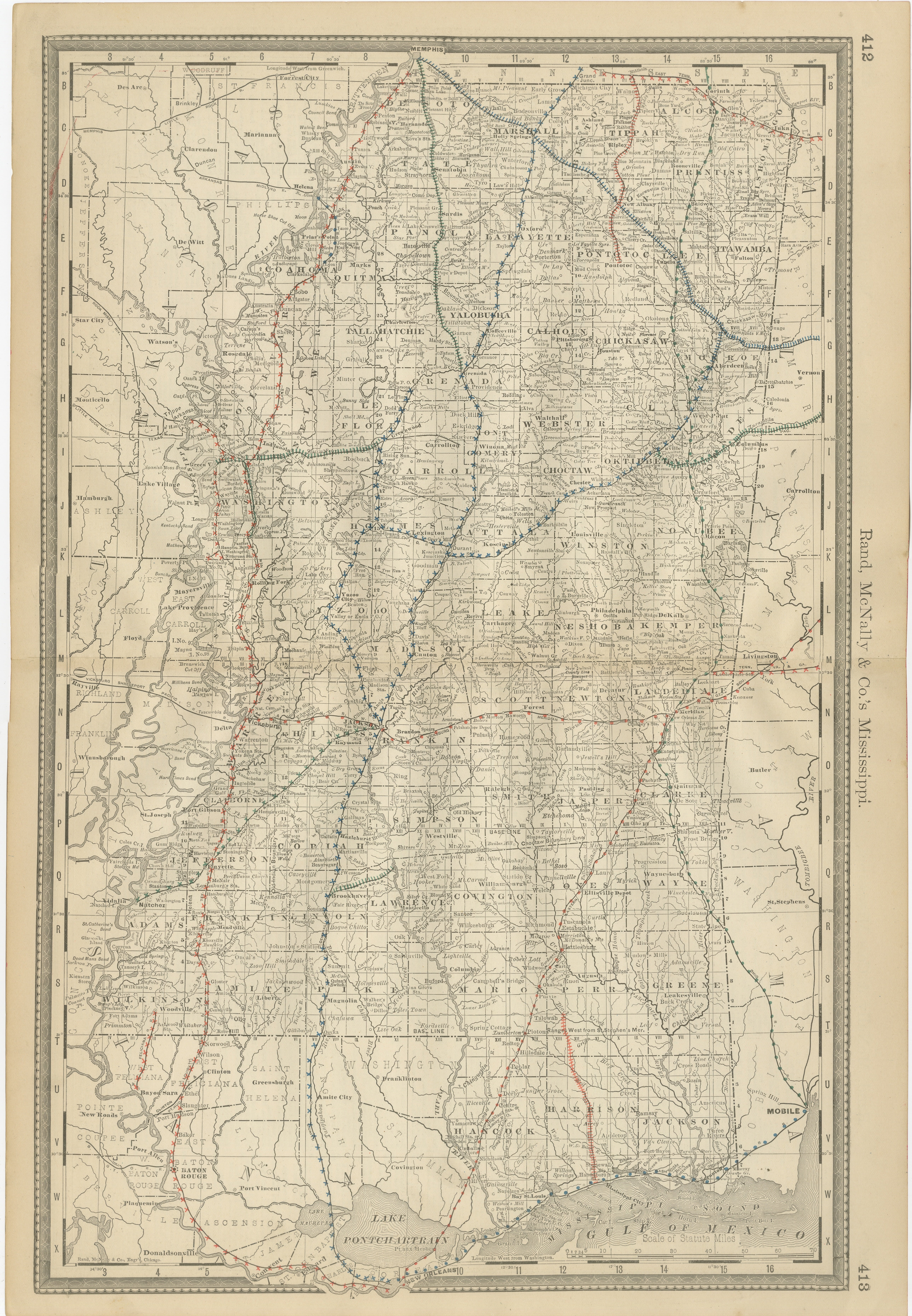
View AllMississippi Antique Map 1888 – The Magnolia State, Railroads & Counties
Located in Langweer, NL
Mississippi Map 1888 – Rand McNally Antique Lithograph
This antique 1888 map of Mississippi, published by Rand, McNally & Co., provides a highly detailed representation of the state...
Category
Antique Late 19th Century American Maps
Materials
Paper
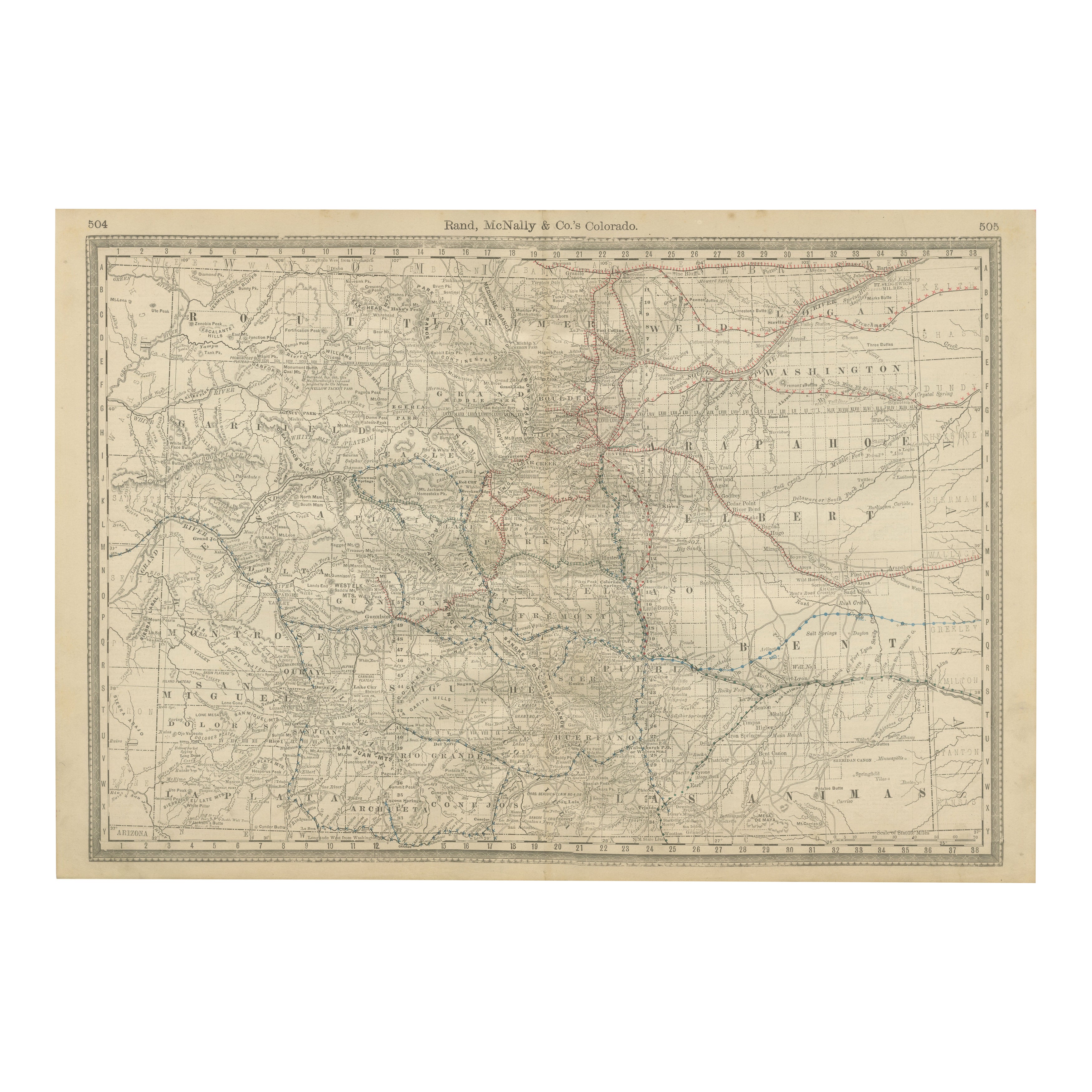
1888 Colorado Map – The Centennial State’s Railroads, Mines & Counties
Located in Langweer, NL
Antique Map of Colorado – Railroads, Mining Towns & Counties, 1888
This antique engraved map depicts the state of Colorado in 1888, published by Rand, McNally & Co. in Chicago for t...
Category
Antique Late 19th Century American Maps
Materials
Paper
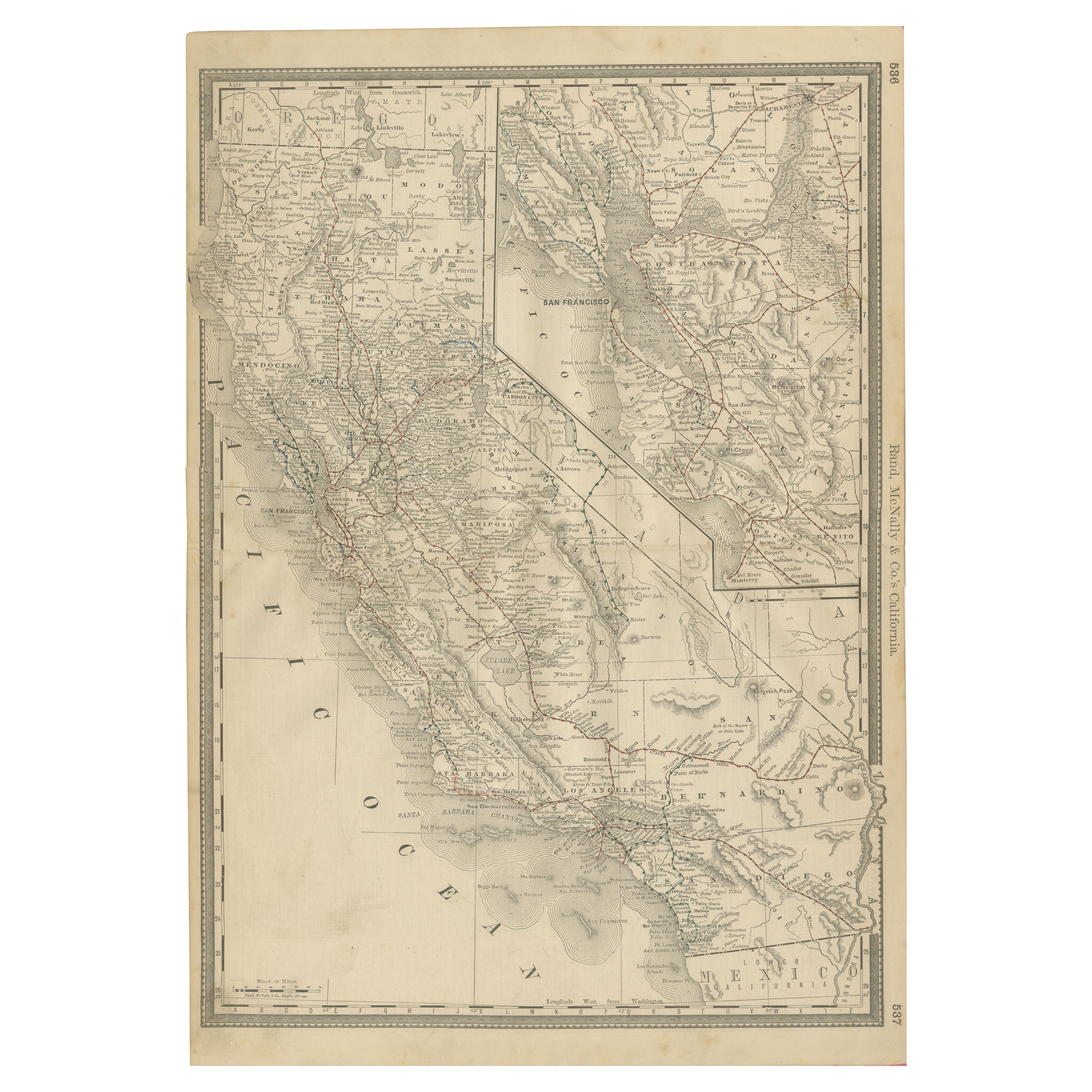
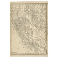
1888 California Map – The Golden State’s Railroads, Cities & Counties
Located in Langweer, NL
Antique Map of California – Railroads, Cities & Counties, 1888
This antique engraved map shows California in 1888, at a time of enormous growth and transformation. Published by Rand...
Category
Antique Late 19th Century American Maps
Materials
Paper
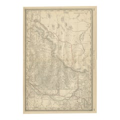
1888 Idaho Map – The Gem State’s Railroads, Mining Camps & Counties
Located in Langweer, NL
Antique Map of Idaho – Railroads, Mining Camps & Counties, 1888
This antique engraved map depicts the Territory of Idaho in 1888, engraved and published by Rand, McNally & Co. in Ch...
Category
Antique Late 19th Century American Maps
Materials
Paper
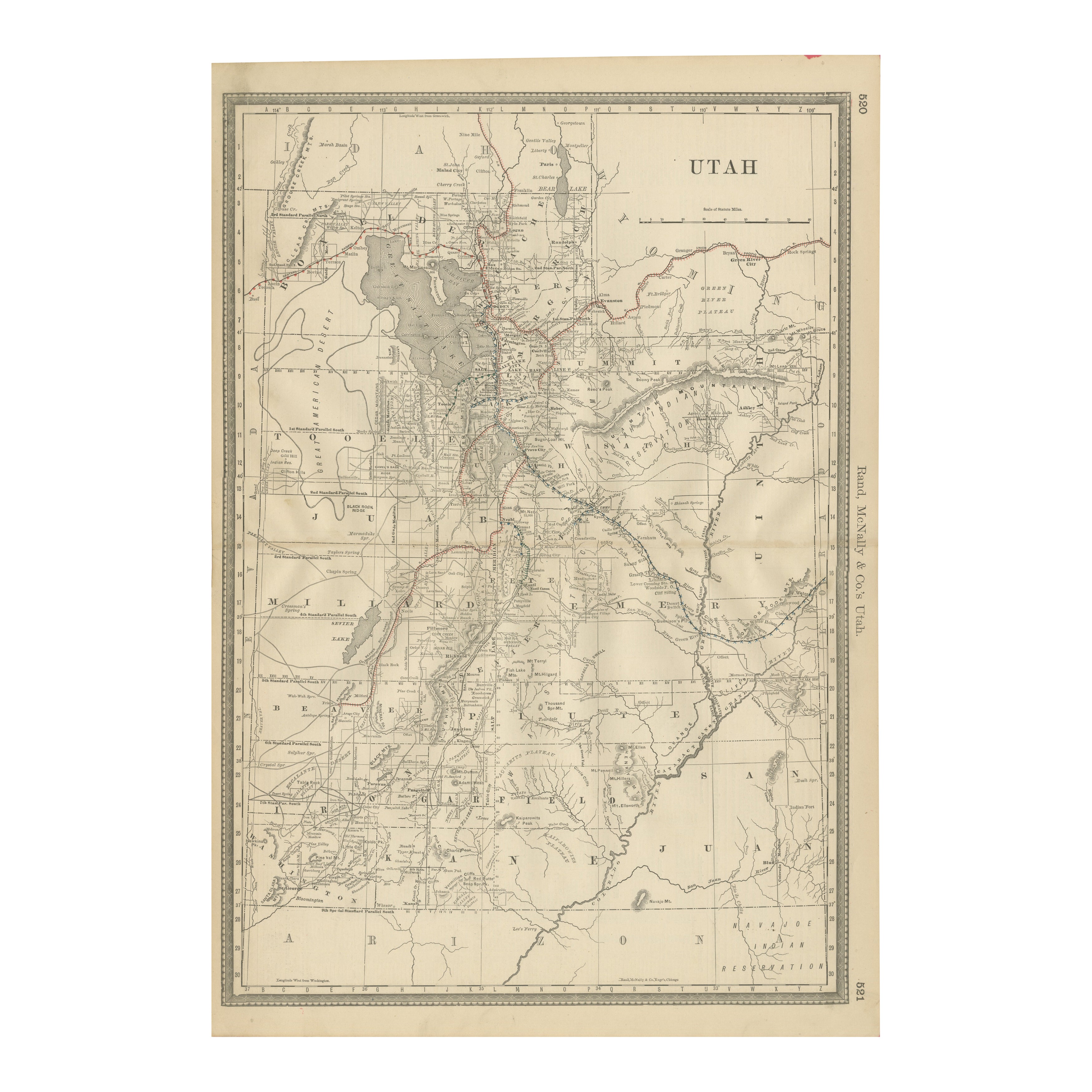
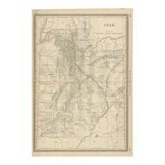
Rare 1888 Utah Map – The Beehive State’s Railroads, Counties & Great Salt Lake
Located in Langweer, NL
Antique Map of Utah – Railroads, Counties & Great Salt Lake, 1888
This antique engraved map presents the Territory of Utah in 1888, published by Rand, McNally & Co. in Chicago for t...
Category
Antique Late 19th Century American Maps
Materials
Paper
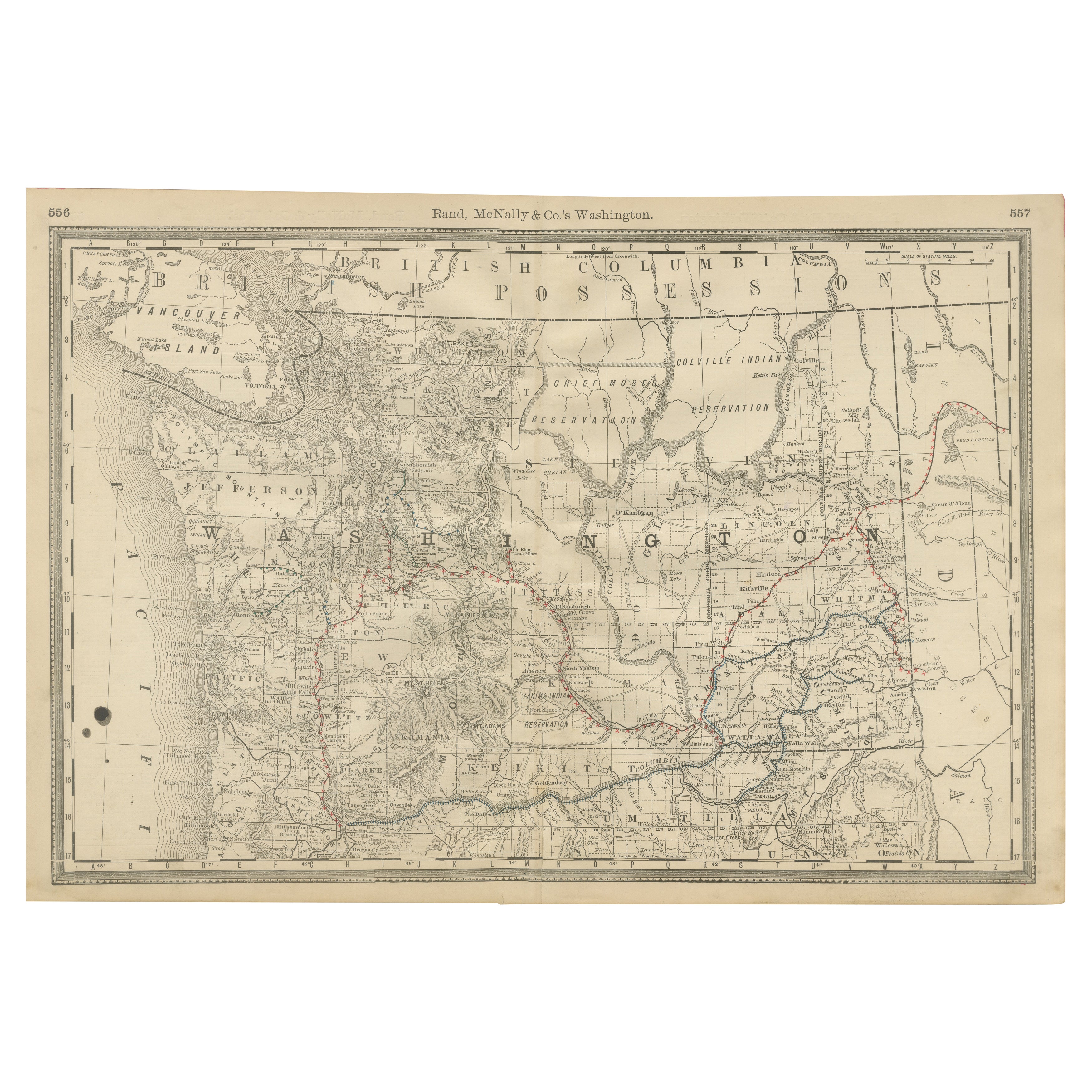
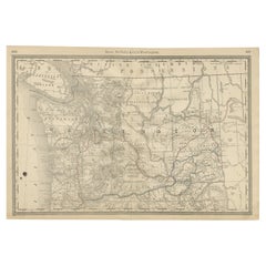
Washington Map 1888 – Antique Railroads, Indian Reservations & Counties
Located in Langweer, NL
Antique Map of Washington – Railroads, Counties & Indian Reservations, 1888
This original engraved map shows the Territory of Washington in 1888, a historically important moment jus...
Category
Antique Late 19th Century American Maps
Materials
Paper
You May Also Like
Original Antique Map of the American State of Louisiana, 1903
Located in St Annes, Lancashire
Antique map of Louisiana
Published By A & C Black. 1903
Original colour
Good condition
Unframed.
Free shipping
Category
Antique Early 1900s English Maps
Materials
Paper

1899 Poole Brothers Antique Railroad Map of the Illinois Central Railroad
Located in Colorado Springs, CO
This is an 1899 railroad map of the Illinois Central and Yazoo and Mississippi Valley Railroads, published by the Poole Brothers. The map focuses on the continuous United States from the Atlantic to the Pacific Oceans, the Gulf of Mexico, and the Antilles. Remarkably detailed, the rail routes of the Illinois Central RR are marked in red, which each stop labeled. Major stops are overprinted in red, bold letters, with the short rail distances to New York listed above the stop and short rail distances to New Orleans listed below the name.
In addition to the Illinois Central network, numerous different rail lines are illustrated and the company running that line is noted along with many stops along each route. Sea routes from New Orleans to locations in Central America, the Caribbean, and Europe are marked and labeled with destination and distance, along with routes originating from Havana. Inset at bottom left is a map of Cuba; an inset map of Puerto Rico...
Category
Antique 1890s American Maps
Materials
Paper

Large Original Antique Map of Louisiana, USA, C.1900
Located in St Annes, Lancashire
Fabulous map of Louisiana.
Original color.
Engraved and printed by the George F. Cram Company, Indianapolis.
Published, c.1900.
Unframed.
Repair ...
Category
Antique 1890s American Maps
Materials
Paper
Original Antique Map of the American State of Washington, 1889
Located in St Annes, Lancashire
Great map of Washington
Drawn and Engraved by W. & A.K. Johnston
Published By A & C Black, Edinburgh.
Original colour
Unframed.
Category
Antique 1880s Scottish Victorian Maps
Materials
Paper

Original Antique Map of the American State of Oregon, 1889
Located in St Annes, Lancashire
Great map of Oregon
Drawn and Engraved by W. & A.K. Johnston
Published By A & C Black, Edinburgh.
Original colour
Unframed.
Category
Antique 1880s Scottish Victorian Maps
Materials
Paper
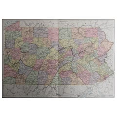
Original Antique Map of the American State of Pennsylvania, 1889
Located in St Annes, Lancashire
Great map of Pennsylvania
Drawn and Engraved by W. & A.K. Johnston
Published By A & C Black, Edinburgh.
Original colour
Unframed.
Repair to a minor tear on bottom edge.
Category
Antique 1880s Scottish Victorian Maps
Materials
Paper