Items Similar to Map of Aude France with Carcassonne and Languedoc Vineyards, 19th Century


Want more images or videos?
Request additional images or videos from the seller
1 of 10
Map of Aude France with Carcassonne and Languedoc Vineyards, 19th Century
$143.90
£107.05
€120
CA$197.05
A$219.09
CHF 114.40
MX$2,666.90
NOK 1,459.67
SEK 1,367.64
DKK 913.49
Shipping
Retrieving quote...The 1stDibs Promise:
Authenticity Guarantee,
Money-Back Guarantee,
24-Hour Cancellation
About the Item
Map of Aude France with Carcassonne and Languedoc Vineyards, 19th Century
Description:
This elegant 19th-century map of Aude, a department in southern France along the Mediterranean coast, was engraved for the Nouvel Atlas Illustré and published in Paris by Migeon. It offers a rich visual and historical depiction of a region known for its medieval heritage, wine production, and proximity to both the Pyrenees and the Mediterranean Sea.
The map presents the full layout of Aude with towns, roads, and rivers carefully labeled, and department borders highlighted in soft hand-applied lavender tones. At the center lies Carcassonne, one of the most iconic fortified cities in Europe, whose medieval citadel is a UNESCO World Heritage site. The surrounding landscape is marked by mountain foothills, river valleys, and vineyards, reflecting the area's diverse topography.
To the left is a portrait of General Antoine-François Andréossy, a distinguished artillery officer and diplomat born in Castelnaudary. Below him, an engraving depicts a southern French village with a Romanesque church, typical of the Aude countryside. In the lower right corner, a lively harbor view shows the port at Gruissan, linking the department to Mediterranean trade and culture. The inclusion of the coat of arms and classical decorative motifs adds to the historical charm of the print.
Aude is part of the historic Languedoc wine region and is especially known for producing robust red wines and sparkling wines like Blanquette de Limoux, considered by many to be the world’s oldest sparkling wine. The vineyards around Limoux and the Corbières hills yield Grenache, Syrah, Mourvèdre, and other varietals that define the rich, earthy character of southern French wines. The climate, shaped by both mountain and sea, creates ideal growing conditions.
This map is not only a piece of cartographic history but also a reflection of the cultural identity of Aude during the 19th century, capturing its architecture, prominent individuals, and viticultural heritage.
Condition summary:
Very good condition with light toning around the edges and minor foxing in the margins. Engraving is crisp and the original hand coloring remains bright and clean.
Framing tips:
A warm wood or gilded frame would enhance the classic feel of this map. Pair it with an off-white or pale grey mat to complement the pastel coloring. UV-protective glass is recommended to preserve the paper and detail.
- Dimensions:Height: 10.28 in (26.1 cm)Width: 12.8 in (32.5 cm)Depth: 0.01 in (0.2 mm)
- Materials and Techniques:Paper,Engraved
- Place of Origin:
- Period:
- Date of Manufacture:circa 1850
- Condition:Very good condition with light toning around the edges and minor foxing in the margins. Engraving is crisp and the original hand coloring remains bright and clean.
- Seller Location:Langweer, NL
- Reference Number:Seller: BG-13331-101stDibs: LU3054345359612
About the Seller
5.0
Recognized Seller
These prestigious sellers are industry leaders and represent the highest echelon for item quality and design.
Platinum Seller
Premium sellers with a 4.7+ rating and 24-hour response times
Established in 2009
1stDibs seller since 2017
2,510 sales on 1stDibs
Typical response time: <1 hour
- ShippingRetrieving quote...Shipping from: Langweer, Netherlands
- Return Policy
Authenticity Guarantee
In the unlikely event there’s an issue with an item’s authenticity, contact us within 1 year for a full refund. DetailsMoney-Back Guarantee
If your item is not as described, is damaged in transit, or does not arrive, contact us within 7 days for a full refund. Details24-Hour Cancellation
You have a 24-hour grace period in which to reconsider your purchase, with no questions asked.Vetted Professional Sellers
Our world-class sellers must adhere to strict standards for service and quality, maintaining the integrity of our listings.Price-Match Guarantee
If you find that a seller listed the same item for a lower price elsewhere, we’ll match it.Trusted Global Delivery
Our best-in-class carrier network provides specialized shipping options worldwide, including custom delivery.More From This Seller
View AllMap of Ardèche France with Annonay and Vineyards by Vuillemin, 19th c
Located in Langweer, NL
Map of Ardèche France with Annonay and Vineyards by Vuillemin, 19th c
This beautifully engraved 19th-century map of Ardèche, a department in southeastern France, comes from Alexandr...
Category
Antique Mid-19th Century French Maps
Materials
Paper

Map of Allier France with Saint-Pourçain Wine Region by Vuillemin, 19th c
Located in Langweer, NL
Map of Allier France with Saint-Pourçain Wine Region by Vuillemin, 19th c
This decorative 19th-century map of Allier, a central department of France, comes from the celebrated Nouve...
Category
Antique Mid-19th Century French Maps
Materials
Paper

Map of Ariège France with Foix and Pyrenees Landscape by Vuillemin, 19th c
Located in Langweer, NL
Map of Ariège France with Foix and Pyrenees Landscape by Vuillemin, 19th c
Description:
This beautifully detailed 19th-century map of the Ariège department in southwestern France wa...
Category
Antique Mid-19th Century French Maps
Materials
Paper

Map of Gard France with Pont du Gard and Wine Regions by Vuillemin, 19th c
Located in Langweer, NL
Title: Map of Gard France with Pont du Gard and Wine Regions by Vuillemin, 19th c
Description:
This finely engraved 19th-century map of the department of Gard in southern France was...
Category
Antique Mid-19th Century French Maps
Materials
Paper

Map of Aube France with Troyes and Champagne Wine Region, 19th Century
Located in Langweer, NL
Map of Aube France with Troyes and Champagne Vineyards by Vuillemin, 19th c
Description:
This 19th-century map of the Aube department in the Grand Est region of northeastern France ...
Category
Antique Mid-19th Century French Maps
Materials
Paper

Map of Côtes-du-Nord France with Saint-Brieuc and Brittany Coastline, c.1850
Located in Langweer, NL
Map of Côtes-du-Nord France with Saint-Brieuc and Brittany Coastline, 19th c
Description:
This elegant 19th-century map of Côtes-du-Nord, the historic name for what is now known as ...
Category
Antique Mid-19th Century French Maps
Materials
Paper

You May Also Like
Aude, France. Antique map of a French department, 1856
By Victor Levasseur
Located in Melbourne, Victoria
'Dept. de L' Aude', steel engraving with original outline hand-colouring., 1856, from Levasseur's 'Atlas National Illustre'.
This area of France is famous for its wide variety of v...
Category
19th Century Naturalistic Landscape Prints
Materials
Engraving

Aube, France. Antique map of a French department, 1856
By Victor Levasseur
Located in Melbourne, Victoria
'Dept. de L'Aube', steel engraving with original outline hand-colouring., 1856, from Levasseur's 'Atlas National Illustre'.
This area of France is known for its production of Chaou...
Category
19th Century Naturalistic Landscape Prints
Materials
Engraving

Large 19th Century Map of France
Located in Pease pottage, West Sussex
Large 19th Century Map of France.
Remarkable condition, with a pleasing age worn patina.
Recently framed.
France Circa 1874.
Category
Antique Late 19th Century French Maps
Materials
Linen, Paper

Saone and Loire, France. Antique map of a French department, 1856
By Victor Levasseur
Located in Melbourne, Victoria
'Dept. de Saone et Loire', steel engraving with original outline hand-colouring., 1856, from Levasseur's Atlas National Illustre.
The French department of Saone et Loire is at the ...
Category
19th Century Naturalistic Landscape Prints
Materials
Engraving

Map of Haute Vienne - Original Lithograph - 19th Century
Located in Roma, IT
Map of Haute Vienne is an original lithograph artwork realized by an Anonymous engraver of the 19th century.
Printed in the series of "France Pittoresque".
Titled "France Pittore...
Category
19th Century Modern Figurative Prints
Materials
Lithograph

Calvados, France. Antique map of a French department, 1856
By Victor Levasseur
Located in Melbourne, Victoria
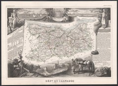
'Dept. du Calvados', steel engraving with original outline hand-colouring., 1856, from Levasseur's 'Atlas National Illustre'.
This area of France is known for its production of Cal...
Category
19th Century Naturalistic Landscape Prints
Materials
Engraving
More Ways To Browse
Vineyard Furniture
French Wine Map
Antique Wine Labels
Port Wine
Port Wine Glasses
Nouvel Glass
Romanesque Light
6x10 Rug
Styles Of Antique Desks
Black And White Coffee Table
Metal Relief
Curved Velvet Couch
Velvet Curved Sofa
Wood Round Coffee Tables
Antique Paper Flowers
Oak Brutalist
Used College Furniture
Wood Minimalist Chair