Items Similar to Map of Calvados France with Caen and Cider-Brandy Region, 19th Century


Want more images or videos?
Request additional images or videos from the seller
1 of 10
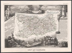
Map of Calvados France with Caen and Cider-Brandy Region, 19th Century
$139.82
£105.45
€120
CA$193.32
A$216.55
CHF 113.74
MX$2,633.16
NOK 1,440.31
SEK 1,367.24
DKK 913.52
About the Item
Map of Calvados France with Caen and Cider-Brandy Region, 19th Century
Description:
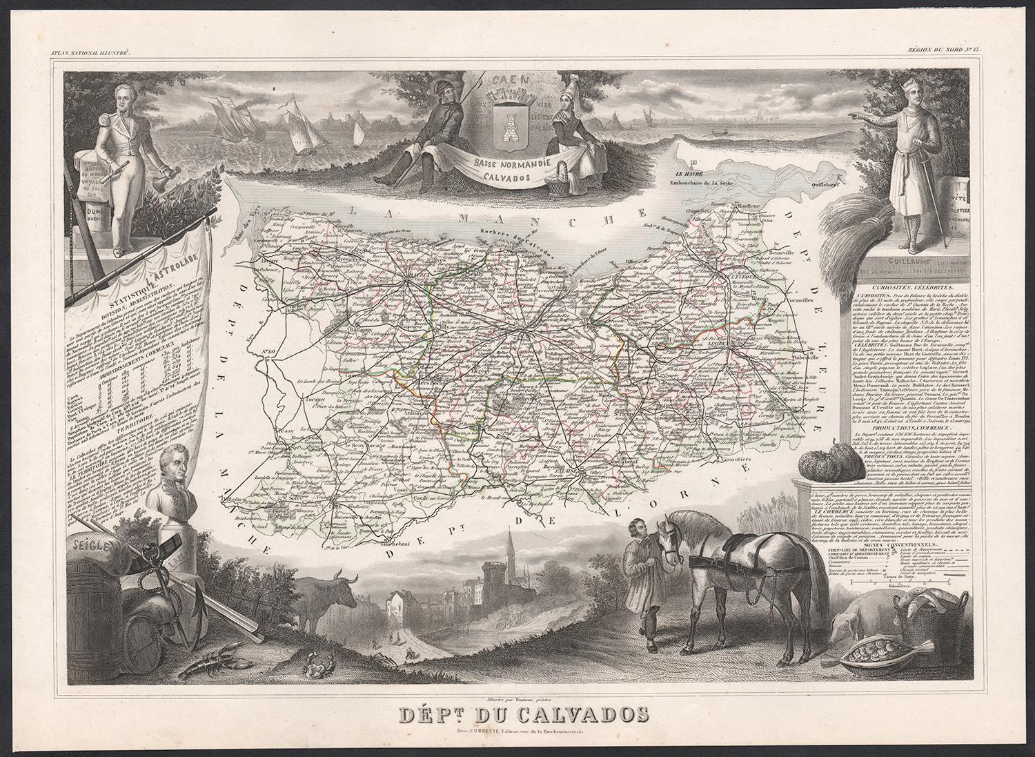
This finely engraved 19th-century map of the Calvados department in Normandy, northwestern France, comes from the *Nouvel Atlas Illustré* published in Paris by Migeon. The map was drawn by Alexandre Vuillemin and features a rich combination of precise geography and elegant embellishments, reflecting the historical and agricultural importance of this coastal region.
The map outlines Calvados in soft pink hand-coloring, highlighting towns, rivers, and roads, with the English Channel (La Manche) bordering the north. Caen, the department's capital and a cultural center since medieval times, is prominently positioned. The cartographic detailing includes the famed Norman countryside and coast, which played a vital role in French history and later in World War II.
In the lower left is a portrait of Dumont d’Urville, the explorer and naval officer born in Condé-sur-Noireau in Calvados. He is shown with nautical instruments, referencing his significant contributions to French exploration and science. In the lower right is a finely rendered view of the city of Caen, with its imposing Gothic architecture, likely representing the Church of Saint-Pierre or the Abbey of Saint-Étienne founded by William the Conqueror.
Calvados is perhaps best known for its namesake apple brandy, produced in the rolling orchards that stretch across the region. The department lies at the heart of the Calvados AOC, where cider apples are grown and distilled into one of France’s most iconic spirits. Alongside Calvados brandy, the region also produces fine cider, pommeau, and a range of cheeses, most notably Pont-l'Évêque and Livarot. These agricultural products have earned Calvados a reputation for rustic elegance and culinary depth.
This map captures the spirit of Normandy's maritime heritage, its agricultural landscape, and its intellectual legacy, making it ideal for collectors of historic French regions or food and wine enthusiasts.
Condition summary:
Very good condition with some light toning and minor foxing to the margins. The engraved detail is crisp, and the original hand coloring is well preserved.
Framing tips:
A rustic oak or walnut frame would match the map’s Norman character. A soft ivory or light grey mat will highlight the pink border color and the engraved vignette of Caen. Use museum-quality glass to protect and enhance the print for display.
- Dimensions:Height: 10.28 in (26.1 cm)Width: 12.8 in (32.5 cm)Depth: 0.01 in (0.2 mm)
- Materials and Techniques:Paper,Engraved
- Place of Origin:
- Period:
- Date of Manufacture:circa 1850
- Condition:Very good condition with some light toning and minor foxing to the margins. The engraved detail is crisp, and the original hand coloring is well preserved.
- Seller Location:Langweer, NL
- Reference Number:Seller: BG-13331-131stDibs: LU3054345359802
About the Seller
5.0
Recognized Seller
These prestigious sellers are industry leaders and represent the highest echelon for item quality and design.
Platinum Seller
Premium sellers with a 4.7+ rating and 24-hour response times
Established in 2009
1stDibs seller since 2017
2,517 sales on 1stDibs
Typical response time: <1 hour
- ShippingRetrieving quote...Shipping from: Langweer, Netherlands
- Return Policy
Authenticity Guarantee
In the unlikely event there’s an issue with an item’s authenticity, contact us within 1 year for a full refund. DetailsMoney-Back Guarantee
If your item is not as described, is damaged in transit, or does not arrive, contact us within 7 days for a full refund. Details24-Hour Cancellation
You have a 24-hour grace period in which to reconsider your purchase, with no questions asked.Vetted Professional Sellers
Our world-class sellers must adhere to strict standards for service and quality, maintaining the integrity of our listings.Price-Match Guarantee
If you find that a seller listed the same item for a lower price elsewhere, we’ll match it.Trusted Global Delivery
Our best-in-class carrier network provides specialized shipping options worldwide, including custom delivery.More From This Seller
View AllMap of Allier France with Saint-Pourçain Wine Region by Vuillemin, 19th c
Located in Langweer, NL
Map of Allier France with Saint-Pourçain Wine Region by Vuillemin, 19th c
This decorative 19th-century map of Allier, a central department of France, comes from the celebrated Nouve...
Category
Antique Mid-19th Century French Maps
Materials
Paper

Map of Côtes-du-Nord France with Saint-Brieuc and Brittany Coastline, c.1850
Located in Langweer, NL
Map of Côtes-du-Nord France with Saint-Brieuc and Brittany Coastline, 19th c
Description:
This elegant 19th-century map of Côtes-du-Nord, the historic name for what is now known as ...
Category
Antique Mid-19th Century French Maps
Materials
Paper

Map of Côte-d'Or France with Dijon and Burgundy Wine Region, 19th Century
Located in Langweer, NL
Map of Côte-d'Or France with Dijon and Burgundy Wine Region, 19th Century
Description:
This beautifully engraved 19th-century map of Côte-d'Or, located in the historic region of Bur...
Category
Antique Mid-19th Century French Maps
Materials
Paper

Antique Map of Calvados ‘France’ by V. Levasseur, 1854
By Victor Levasseur
Located in Langweer, NL
Antique map titled 'Dépt. du Calvados'. Map of the French department of Calvados, France. This area of France is known for its production of Calvados, the world's fines apple brandy....
Category
Antique Mid-19th Century Maps
Materials
Paper
$186 Sale Price
20% Off
Map of Aude France with Carcassonne and Languedoc Vineyards, 19th Century
Located in Langweer, NL
Map of Aude France with Carcassonne and Languedoc Vineyards, 19th Century
Description:
This elegant 19th-century map of Aude, a department in southern France along the Mediterranean...
Category
Antique Mid-19th Century French Maps
Materials
Paper

Antique Map of Calais ‘France’ by V. Levasseur, 1854
By Victor Levasseur
Located in Langweer, NL
Antique map titled 'Dépt. du Pas de Calais'. Map of the French department of Calais, France. This area is known for producing Maroilles, a soft cheese made from cow’s milk and with a...
Category
Antique Mid-19th Century Maps
Materials
Paper
$167 Sale Price
20% Off
You May Also Like
Calvados, France. Antique map of a French department, 1856
By Victor Levasseur
Located in Melbourne, Victoria
'Dept. du Calvados', steel engraving with original outline hand-colouring., 1856, from Levasseur's 'Atlas National Illustre'.
This area of France is known for its production of Cal...
Category
19th Century Naturalistic Landscape Prints
Materials
Engraving
Large 19th Century Map of France
Located in Pease pottage, West Sussex
Large 19th Century Map of France.
Remarkable condition, with a pleasing age worn patina.
Recently framed.
France Circa 1874.
Category
Antique Late 19th Century French Maps
Materials
Linen, Paper

Circa 1950 original map poster of Calvados, designed by André Lesot - Normandy
Located in PARIS, FR
This circa 1950 original map poster of Calvados, designed by André Lesot, is a beautifully detailed representation of this historic region in Normandy, France. Produced by Éditions G...
Category
1950s Prints and Multiples
Materials
Lithograph, Paper, Linen
Aude, France. Antique map of a French department, 1856
By Victor Levasseur
Located in Melbourne, Victoria
'Dept. de L' Aude', steel engraving with original outline hand-colouring., 1856, from Levasseur's 'Atlas National Illustre'.
This area of France is famous for its wide variety of v...
Category
19th Century Naturalistic Landscape Prints
Materials
Engraving

The Normandy Region of France: A 17th C. Hand-colored Map by Sanson and Jaillot
By Nicolas Sanson
Located in Alamo, CA
This large hand-colored map entitled "Le Duché et Gouvernement de Normandie divisée en Haute et Basse Normandie en divers Pays; et par evêchez, avec le Gouvernement General du Havre ...
Category
Antique 1690s French Maps
Materials
Paper

Var, France. Antique map of a French department, 1856
By Victor Levasseur
Located in Melbourne, Victoria
'Dept. du Var', steel engraving with original outline hand-colouring., 1856, from Levasseur's Atlas National Illustre.
Var covers the heart of the French Riviera or Cote d'Azur., and includes the resort cities of Cannes, Nice and San Tropez...
Category
19th Century Naturalistic Landscape Prints
Materials
Engraving

More Ways To Browse
Antique Ivory Collectables
Abbey Antique
French Wine Map
Pink Wine Glass
Antique Brandy
Antique Brandy Glasses
Nouvel Glass
William The Conqueror
Pierre Dumont
6x10 Rug
Styles Of Antique Desks
Black And White Coffee Table
Metal Relief
Curved Velvet Couch
Velvet Curved Sofa
Wood Round Coffee Tables
Antique Paper Flowers
Oak Brutalist