Items Similar to Map of Charente France with Cognac Region and Château de La Rochefoucauld, 1850


Want more images or videos?
Request additional images or videos from the seller
1 of 10
Map of Charente France with Cognac Region and Château de La Rochefoucauld, 1850
$143.90
£107.05
€120
CA$197.05
A$219.09
CHF 114.40
MX$2,666.90
NOK 1,459.67
SEK 1,367.64
DKK 913.49
Shipping
Retrieving quote...The 1stDibs Promise:
Authenticity Guarantee,
Money-Back Guarantee,
24-Hour Cancellation
About the Item
Map of Charente France with Cognac Region and Château de La Rochefoucauld, 19th c
Description:
This richly illustrated 19th-century map of the Charente department in southwestern France was published in Paris by Migeon as part of the *Nouvel Atlas Illustré*. Drawn by Alexandre Vuillemin, the map combines accurate geography with artistic flourishes that reflect the cultural and historical wealth of this renowned region, particularly known for its world-famous brandy.
Hand-colored in soft violet tones along the borders, the map features detailed engravings of rivers, towns, and roads across the Charente department. Angoulême, the departmental capital, is prominently marked near the center, surrounded by historic communes including Cognac, Jarnac, Ruffec, and Barbezieux. The topography is delicately rendered, emphasizing the undulating countryside of western France.
In the lower right corner is a beautifully engraved vignette of the Château de La Rochefoucauld, one of the most striking Renaissance castles in France. Above it is a portrait of the military leader François de La Rochefoucauld, Duke of La Rochefoucauld and notable author of the famous *Maximes*. To the upper left is a portrait of King François I, born in Cognac, underscoring the region’s royal heritage. A young woman in traditional attire and botanical setting decorates the lower left, adding a pastoral charm to the map’s composition.
The department of Charente is internationally celebrated for the production of Cognac, a world-class brandy made from white grapes grown in the region’s chalky soil. Cognac and nearby towns like Jarnac are home to some of France’s most prestigious distilleries, including Hennessy, Martell, and Courvoisier. The region is also known for producing pineau des Charentes, a fortified wine, and for its strong literary and printing history, especially centered in Angoulême.
This map is a striking tribute to the legacy of the Charente region—its landscape, noble estates, historic personalities, and contribution to global spirits culture.
Condition summary:
Very good condition with light toning and a few minor foxing marks mostly in the margins. The hand coloring is well preserved and the engraving remains crisp and detailed.
Framing tips:
A black or walnut wood frame will pair beautifully with this piece. Use a warm cream or soft grey mat to enhance the tones of the paper and highlight the engraved architectural and portrait details. UV-protective glass is recommended for preservation.
- Dimensions:Height: 10.28 in (26.1 cm)Width: 12.8 in (32.5 cm)Depth: 0.01 in (0.2 mm)
- Materials and Techniques:Paper,Engraved
- Place of Origin:
- Period:
- Date of Manufacture:circa 1850
- Condition:Very good condition with light toning and a few minor foxing marks mostly in the margins. The hand coloring is well preserved and the engraving remains crisp and detailed.
- Seller Location:Langweer, NL
- Reference Number:Seller: BG-13331-151stDibs: LU3054345359882
About the Seller
5.0
Recognized Seller
These prestigious sellers are industry leaders and represent the highest echelon for item quality and design.
Platinum Seller
Premium sellers with a 4.7+ rating and 24-hour response times
Established in 2009
1stDibs seller since 2017
2,510 sales on 1stDibs
Typical response time: <1 hour
- ShippingRetrieving quote...Shipping from: Langweer, Netherlands
- Return Policy
Authenticity Guarantee
In the unlikely event there’s an issue with an item’s authenticity, contact us within 1 year for a full refund. DetailsMoney-Back Guarantee
If your item is not as described, is damaged in transit, or does not arrive, contact us within 7 days for a full refund. Details24-Hour Cancellation
You have a 24-hour grace period in which to reconsider your purchase, with no questions asked.Vetted Professional Sellers
Our world-class sellers must adhere to strict standards for service and quality, maintaining the integrity of our listings.Price-Match Guarantee
If you find that a seller listed the same item for a lower price elsewhere, we’ll match it.Trusted Global Delivery
Our best-in-class carrier network provides specialized shipping options worldwide, including custom delivery.More From This Seller
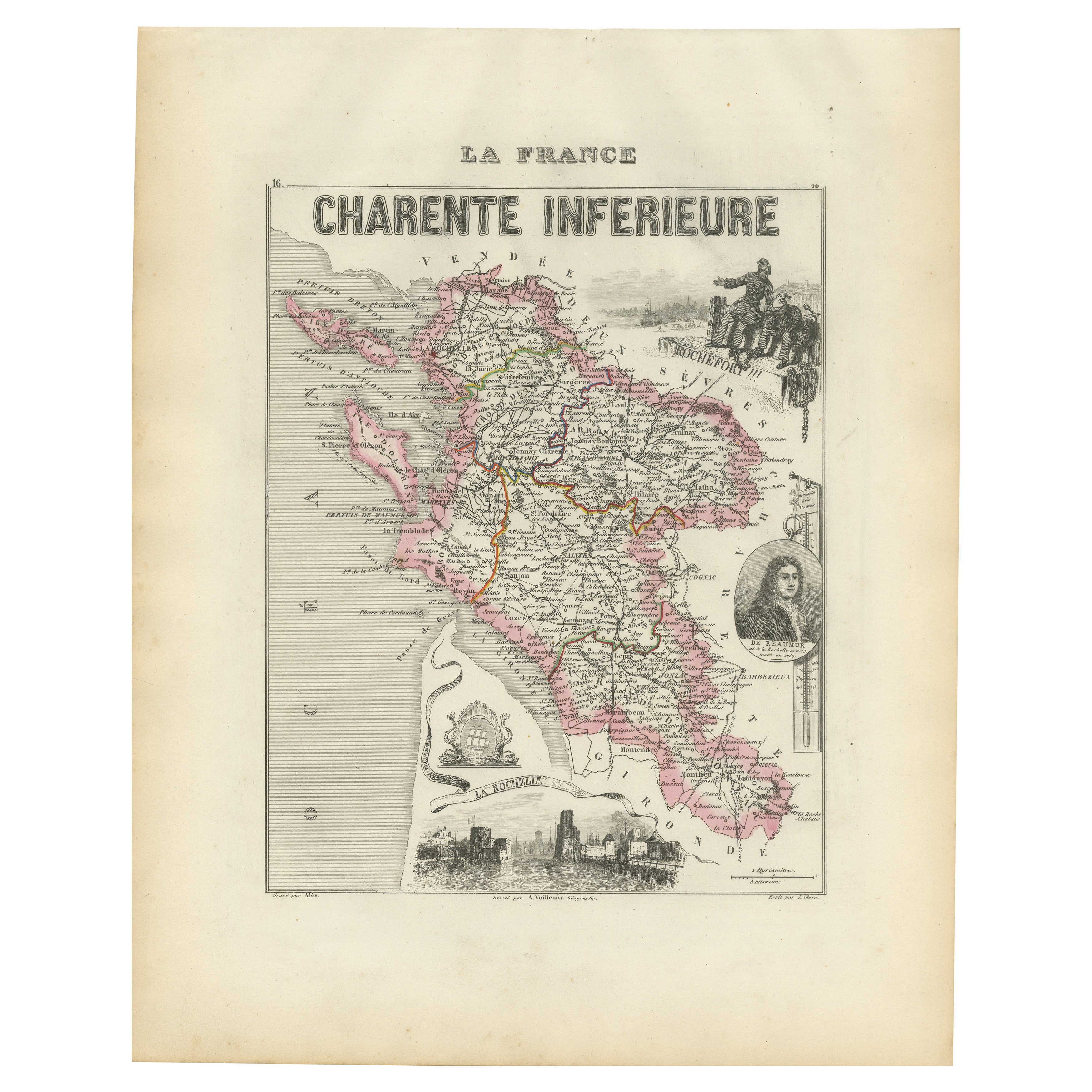
View AllMap of Charente-Inférieure France with La Rochelle and Coastal Vineyards, c.1850
Located in Langweer, NL
Map of Charente-Inférieure France with La Rochelle and Coastal Vineyards, 19th c
Description:
This decorative 19th-century map of the former department of Charente-Inférieure, now k...
Category
Antique Mid-19th Century French Maps
Materials
Paper
Map of Côtes-du-Nord France with Saint-Brieuc and Brittany Coastline, c.1850
Located in Langweer, NL
Map of Côtes-du-Nord France with Saint-Brieuc and Brittany Coastline, 19th c
Description:
This elegant 19th-century map of Côtes-du-Nord, the historic name for what is now known as ...
Category
Antique Mid-19th Century French Maps
Materials
Paper

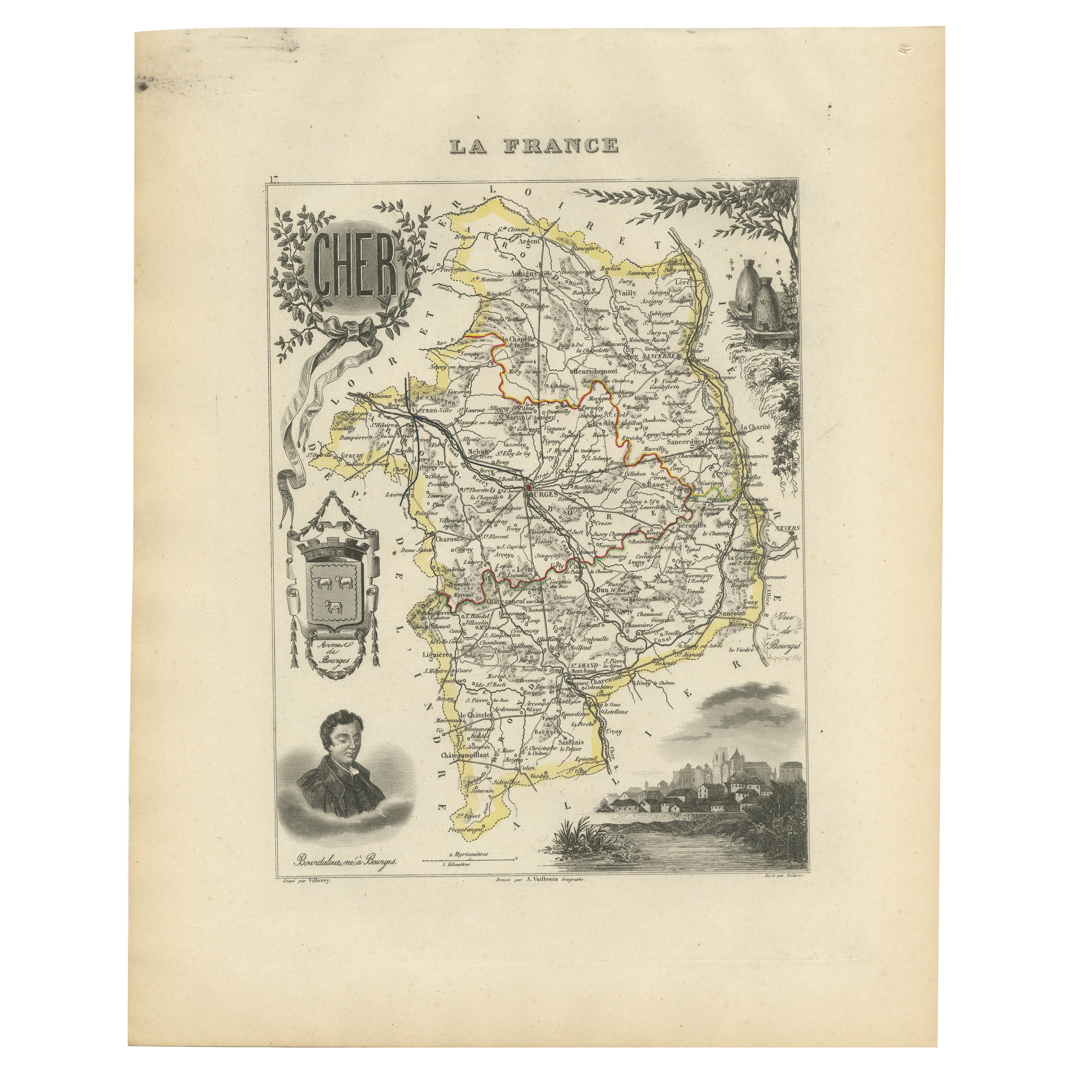
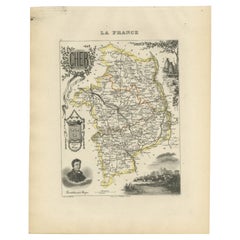
Map of Cher France with Bourges, Sancerre Vineyards and Engraved Vignettes, 1850
Located in Langweer, NL
Map of Charente-Inférieure France with La Rochelle and Coastal Vineyards, 19th c
Description:
This decorative 19th-century map of the former department of Charente-Inférieure, now k...
Category
Antique Mid-19th Century French Maps
Materials
Paper
Map of Allier France with Saint-Pourçain Wine Region by Vuillemin, 19th c
Located in Langweer, NL
Map of Allier France with Saint-Pourçain Wine Region by Vuillemin, 19th c
This decorative 19th-century map of Allier, a central department of France, comes from the celebrated Nouve...
Category
Antique Mid-19th Century French Maps
Materials
Paper

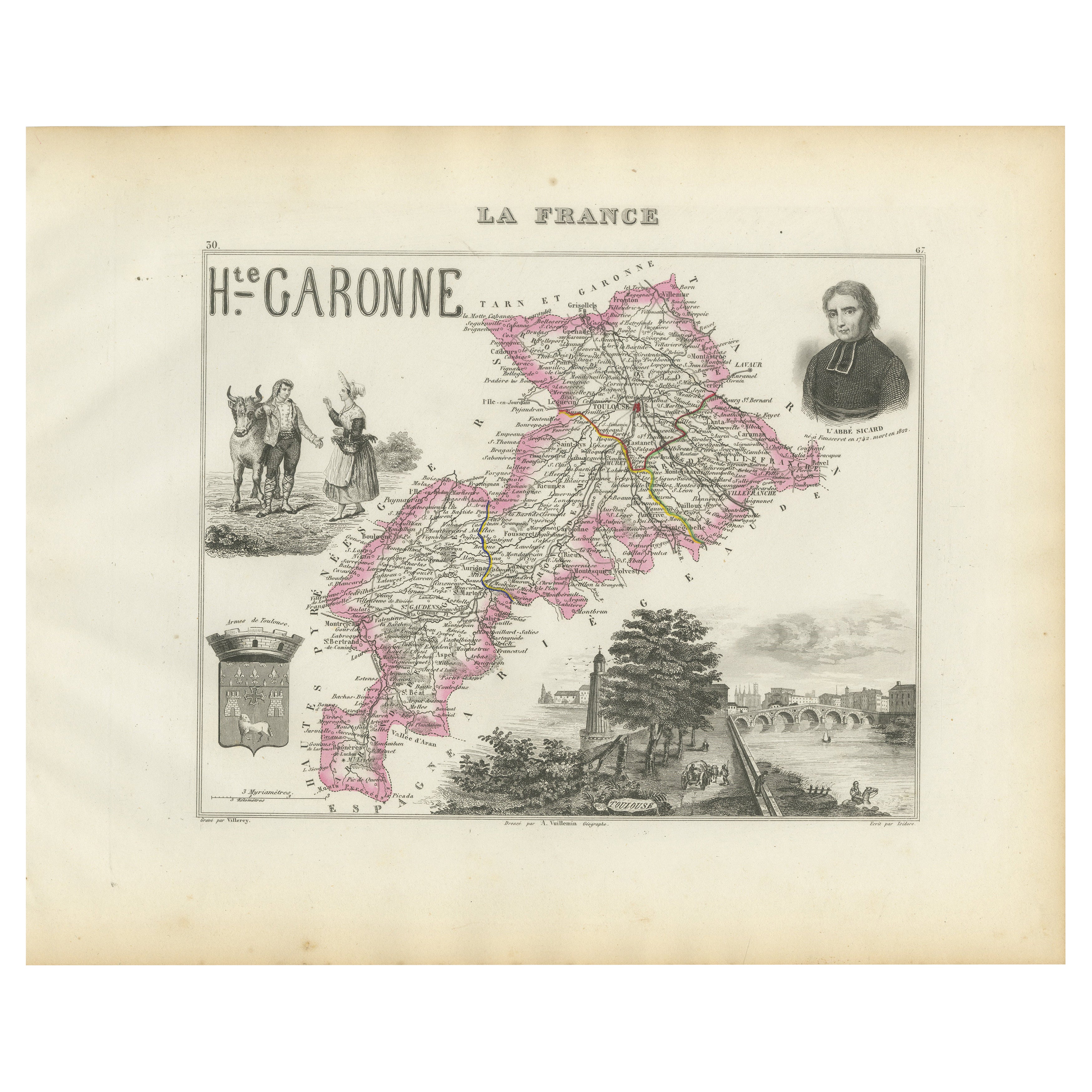
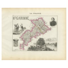
Map of Haute-Garonne France with Toulouse and Garonne River by Vuillemin, c.1850
Located in Langweer, NL
Map of Haute-Garonne France with Toulouse and Garonne River by Vuillemin, 19th c
Description:
This finely engraved 19th-century map of the department of Haute-Garonne, located in so...
Category
Antique Mid-19th Century French Maps
Materials
Paper
Map of Aude France with Carcassonne and Languedoc Vineyards, 19th Century
Located in Langweer, NL
Map of Aude France with Carcassonne and Languedoc Vineyards, 19th Century
Description:
This elegant 19th-century map of Aude, a department in southern France along the Mediterranean...
Category
Antique Mid-19th Century French Maps
Materials
Paper

You May Also Like
Aude, France. Antique map of a French department, 1856
By Victor Levasseur
Located in Melbourne, Victoria
'Dept. de L' Aude', steel engraving with original outline hand-colouring., 1856, from Levasseur's 'Atlas National Illustre'.
This area of France is famous for its wide variety of v...
Category
19th Century Naturalistic Landscape Prints
Materials
Engraving

Saone and Loire, France. Antique map of a French department, 1856
By Victor Levasseur
Located in Melbourne, Victoria
'Dept. de Saone et Loire', steel engraving with original outline hand-colouring., 1856, from Levasseur's Atlas National Illustre.
The French department of Saone et Loire is at the ...
Category
19th Century Naturalistic Landscape Prints
Materials
Engraving

L'Isere, France. Antique map of French department, 1856
By Victor Levasseur
Located in Melbourne, Victoria
'Dept. de L'Isere', Steel engraving with original outline hand-colouring., 1856, from Levasseur's 'Atlas National Illustre'.
This area is known for its production of Bleu du Vercor...
Category
19th Century Naturalistic Landscape Prints
Materials
Engraving

Large 19th Century Map of France
Located in Pease pottage, West Sussex
Large 19th Century Map of France.
Remarkable condition, with a pleasing age worn patina.
Recently framed.
France Circa 1874.
Category
Antique Late 19th Century French Maps
Materials
Linen, Paper

Var, France. Antique map of a French department, 1856
By Victor Levasseur
Located in Melbourne, Victoria
'Dept. du Var', steel engraving with original outline hand-colouring., 1856, from Levasseur's Atlas National Illustre.
Var covers the heart of the French Riviera or Cote d'Azur., and includes the resort cities of Cannes, Nice and San Tropez...
Category
19th Century Naturalistic Landscape Prints
Materials
Engraving

Lozere, France. Antique map of a French department, 1856
By Victor Levasseur
Located in Melbourne, Victoria
'Dept. de La Lozere', steel engraving with original outline hand-colouring., 1856, from Levasseur's 'Atlas National Illustre'.
This remote mountainous part of Languedoc is rural, s...
Category
19th Century Naturalistic Landscape Prints
Materials
Engraving

More Ways To Browse
Chateau De
Cognac Glass
French Wine Map
Antique Cognac
Colored Wine Glass
Antique Brandy
Antique Brandy Glasses
Nouvel Glass
Portrait Of Renaissance Woman
Antique Distillery
Brandy And Cognac Glasses
Brandy Warmer
Antique Brandy Warmer
6x10 Rug
Styles Of Antique Desks
Black And White Coffee Table
Metal Relief
Curved Velvet Couch