Items Similar to Map of Côte-d'Or France with Dijon and Burgundy Wine Region, 19th Century


Want more images or videos?
Request additional images or videos from the seller
1 of 10
Map of Côte-d'Or France with Dijon and Burgundy Wine Region, 19th Century
$167.74
£124.87
€140
CA$229.76
A$255.55
CHF 133.44
MX$3,109.72
NOK 1,704.21
SEK 1,598.24
DKK 1,065.77
Shipping
Retrieving quote...The 1stDibs Promise:
Authenticity Guarantee,
Money-Back Guarantee,
24-Hour Cancellation
About the Item
Map of Côte-d'Or France with Dijon and Burgundy Wine Region, 19th Century
Description:
This beautifully engraved 19th-century map of Côte-d'Or, located in the historic region of Burgundy, was drawn by Alexandre Vuillemin and published by Migeon in Paris as part of the *Nouvel Atlas Illustré*. Meticulously detailed and adorned with elegant vignettes, the map presents one of France’s most prestigious wine regions with geographic clarity and cultural reverence.
The map is bordered in soft pink watercolor and includes all major roads, rivers, and towns. Dijon, the department’s capital and a center of culture and gastronomy, is prominently marked, as are Beaune, Nuits-Saint-Georges, and other key communes of the Côte d’Or vineyard belt. The topography emphasizes the region’s east-facing slopes that form the heart of the wine-producing Côte de Nuits and Côte de Beaune.
In the lower left is an engraving of the city of Dijon, framed by its Gothic spires and medieval architecture. In the upper right is a portrait of a notable local figure, finely framed with ornamental detailing. The departmental coat of arms appears in the upper left, flanked by grapevines and acanthus leaves, alluding to the wine heritage of the region.
Côte-d'Or is home to some of the world’s most renowned vineyards, producing exceptional Pinot Noir and Chardonnay wines. The Côte de Nuits is celebrated for its powerful, age-worthy reds, including grand crus like Romanée-Conti and Clos de Vougeot. The Côte de Beaune is known for both outstanding reds and whites, with names such as Meursault, Puligny-Montrachet, and Corton-Charlemagne. The region’s complex terroir, centuries-old wine tradition, and strict appellation controls make it a benchmark for fine wine globally.
This map is not only a tribute to the geography of the region but also a beautiful celebration of its vinicultural and architectural achievements. It is ideal for collectors of antique maps, wine history, or French decorative prints.
Condition summary:
Very good condition with minor foxing and some light toning to the outer margins. The hand-coloring remains vibrant, and the engraving is clean and crisp.
Framing tips:
A dark mahogany or black frame pairs elegantly with the refined engraving style and pink border. A warm cream or light grey mat complements the map's historical aesthetic. Use museum-grade glass to protect the artwork and enhance visual clarity.
- Dimensions:Height: 12.8 in (32.5 cm)Width: 10.28 in (26.1 cm)Depth: 0.01 in (0.2 mm)
- Materials and Techniques:Paper,Engraved
- Place of Origin:
- Period:
- Date of Manufacture:circa 1850
- Condition:Very good condition with minor foxing and some light toning to the outer margins. The hand-coloring remains vibrant, and the engraving is clean and crisp.
- Seller Location:Langweer, NL
- Reference Number:Seller: BG-13331-201stDibs: LU3054345363642
About the Seller
5.0
Recognized Seller
These prestigious sellers are industry leaders and represent the highest echelon for item quality and design.
Platinum Seller
Premium sellers with a 4.7+ rating and 24-hour response times
Established in 2009
1stDibs seller since 2017
2,510 sales on 1stDibs
Typical response time: <1 hour
- ShippingRetrieving quote...Shipping from: Langweer, Netherlands
- Return Policy
Authenticity Guarantee
In the unlikely event there’s an issue with an item’s authenticity, contact us within 1 year for a full refund. DetailsMoney-Back Guarantee
If your item is not as described, is damaged in transit, or does not arrive, contact us within 7 days for a full refund. Details24-Hour Cancellation
You have a 24-hour grace period in which to reconsider your purchase, with no questions asked.Vetted Professional Sellers
Our world-class sellers must adhere to strict standards for service and quality, maintaining the integrity of our listings.Price-Match Guarantee
If you find that a seller listed the same item for a lower price elsewhere, we’ll match it.Trusted Global Delivery
Our best-in-class carrier network provides specialized shipping options worldwide, including custom delivery.More From This Seller
View AllMap of Allier France with Saint-Pourçain Wine Region by Vuillemin, 19th c
Located in Langweer, NL
Map of Allier France with Saint-Pourçain Wine Region by Vuillemin, 19th c
This decorative 19th-century map of Allier, a central department of France, comes from the celebrated Nouve...
Category
Antique Mid-19th Century French Maps
Materials
Paper

Map of Côtes-du-Nord France with Saint-Brieuc and Brittany Coastline, c.1850
Located in Langweer, NL
Map of Côtes-du-Nord France with Saint-Brieuc and Brittany Coastline, 19th c
Description:
This elegant 19th-century map of Côtes-du-Nord, the historic name for what is now known as ...
Category
Antique Mid-19th Century French Maps
Materials
Paper

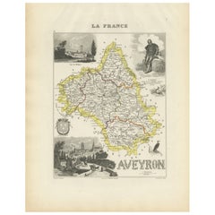
Map of Aveyron France with Rodez, Millau and Wine Routes, 19th Century
Located in Langweer, NL
Map of Aveyron France with Rodez, Millau and Wine Routes, 19th Century
Description:
This detailed and decorative 19th-century map of Aveyron, a department in southern France, was dr...
Category
Antique Mid-19th Century French Maps
Materials
Paper
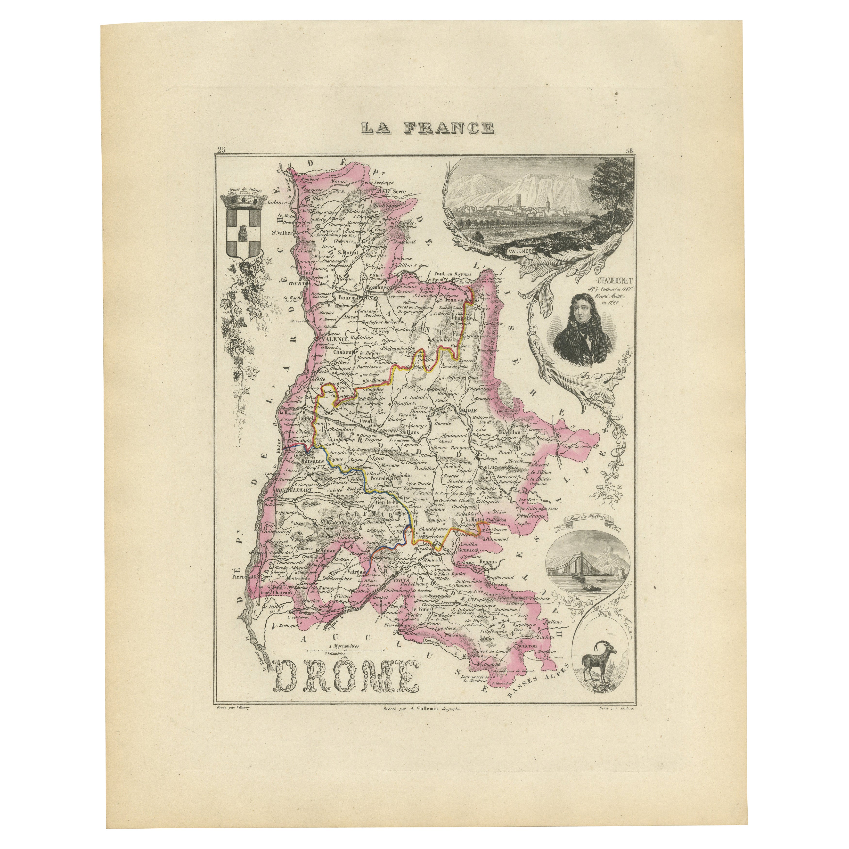
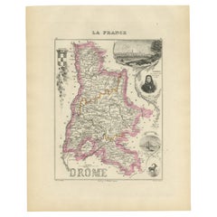
Map of Drôme France with Valence and Rhône Valley Wine Region, 19th Century
Located in Langweer, NL
Map of Drôme France with Valence and Rhône Valley Wine Region, 19th Century
Description:
This beautifully engraved 19th-century map of the Drôme department in southeastern France wa...
Category
Antique Mid-19th Century French Maps
Materials
Paper
Map of Gard France with Pont du Gard and Wine Regions by Vuillemin, 19th c
Located in Langweer, NL
Title: Map of Gard France with Pont du Gard and Wine Regions by Vuillemin, 19th c
Description:
This finely engraved 19th-century map of the department of Gard in southern France was...
Category
Antique Mid-19th Century French Maps
Materials
Paper

Map of Aude France with Carcassonne and Languedoc Vineyards, 19th Century
Located in Langweer, NL
Map of Aude France with Carcassonne and Languedoc Vineyards, 19th Century
Description:
This elegant 19th-century map of Aude, a department in southern France along the Mediterranean...
Category
Antique Mid-19th Century French Maps
Materials
Paper

You May Also Like
Large 19th Century Map of France
Located in Pease pottage, West Sussex
Large 19th Century Map of France.
Remarkable condition, with a pleasing age worn patina.
Recently framed.
France Circa 1874.
Category
Antique Late 19th Century French Maps
Materials
Linen, Paper

France, Northern Part. Century Atlas antique map
Located in Melbourne, Victoria
'The Century Atlas. France, Northern Part.'
Original antique map, 1903.
Inset maps of 'France in Provinces' and 'Paris and Vicinity'.
Central fold as issued. Map name and number pr...
Category
Early 20th Century Victorian More Prints
Materials
Lithograph

Aude, France. Antique map of a French department, 1856
By Victor Levasseur
Located in Melbourne, Victoria
'Dept. de L' Aude', steel engraving with original outline hand-colouring., 1856, from Levasseur's 'Atlas National Illustre'.
This area of France is famous for its wide variety of v...
Category
19th Century Naturalistic Landscape Prints
Materials
Engraving

Aube, France. Antique map of a French department, 1856
By Victor Levasseur
Located in Melbourne, Victoria
'Dept. de L'Aube', steel engraving with original outline hand-colouring., 1856, from Levasseur's 'Atlas National Illustre'.
This area of France is known for its production of Chaou...
Category
19th Century Naturalistic Landscape Prints
Materials
Engraving

Indre and Loire, France. Antique map of a French department, 1856
By Victor Levasseur
Located in Melbourne, Victoria
'Dept. d'Indre et Loire', steel engraving with original outline hand-colouring., 1856, from Levasseur's 'Atlas National Illustre'.
This area is known for its production of Chenin b...
Category
19th Century Naturalistic Landscape Prints
Materials
Engraving

The Normandy Region of France: A 17th C. Hand-colored Map by Sanson and Jaillot
By Nicolas Sanson
Located in Alamo, CA
This large hand-colored map entitled "Le Duché et Gouvernement de Normandie divisée en Haute et Basse Normandie en divers Pays; et par evêchez, avec le Gouvernement General du Havre ...
Category
Antique 1690s French Maps
Materials
Paper
