Items Similar to Map of Drôme France with Valence and Rhône Valley Wine Region, 19th Century


Want more images or videos?
Request additional images or videos from the seller
1 of 10
Map of Drôme France with Valence and Rhône Valley Wine Region, 19th Century
$167.89
£124.89
€140
CA$229.89
A$255.61
CHF 133.46
MX$3,111.38
NOK 1,702.95
SEK 1,595.58
DKK 1,065.74
Shipping
Retrieving quote...The 1stDibs Promise:
Authenticity Guarantee,
Money-Back Guarantee,
24-Hour Cancellation
About the Item
Map of Drôme France with Valence and Rhône Valley Wine Region, 19th Century
Description:
This beautifully engraved 19th-century map of the Drôme department in southeastern France was created by Alexandre Vuillemin and published by Migeon in Paris as part of the *Nouvel Atlas Illustré*. Combining precise geography with classical decoration, this map offers a detailed portrait of a region that bridges the Alpine foothills and the fertile Rhône Valley.
Outlined in soft hand-colored pink, the map includes towns, roads, rivers, and administrative borders. Valence, the departmental capital and a historic gateway to the south of France, is prominently placed near the top. Other notable towns such as Montélimar, Die, and Nyons are labeled with clarity, and the layout captures the topographical transition from mountainous terrain in the east to the flatter Rhône corridor in the west.
At the top right, a vignette of Valence shows the town nestled beneath the Vercors mountains. Below that is a portrait of the French dramatist Pierre-Antoine de Chamfort, who was born in Clermont-Ferrand but had associations with the intellectual life of the region. Additional engravings include a suspension bridge over the Rhône River and an image of a goat, likely referencing the local production of regional cheeses and pastoral traditions.
Drôme lies in the heart of the Côtes du Rhône wine region, particularly its southern section. The department is home to some well-regarded appellations including Crozes-Hermitage, Hermitage, and Clairette de Die. These wines—made from Syrah, Marsanne, Roussanne, and Muscat, among other grapes—are known for their rich textures, spice, and balance. In addition to viticulture, the region is also recognized for truffle production, olive oil, nougat from Montélimar, and lavender fields in the southern zones.
This antique map is a fitting tribute to Drôme’s blend of agricultural richness, cultural history, and natural beauty. It is a wonderful addition to any collection of wine-related maps, regional French art, or decorative cartography.
Condition summary:
Very good condition with slight age toning and a few minor foxing marks along the margins. The engraved lines are sharp and the original hand coloring remains vibrant.
Framing tips:
A walnut or dark oak frame will complement the regional warmth of the Drôme landscape. Use a light cream or muted lavender mat to match the coloring and draw out the engraved vignettes. UV-protective glass is recommended for preservation and clarity.
- Dimensions:Height: 10.28 in (26.1 cm)Width: 12.8 in (32.5 cm)Depth: 0.01 in (0.2 mm)
- Materials and Techniques:Paper,Engraved
- Place of Origin:
- Period:
- Date of Manufacture:circa 1850
- Condition:Very good condition with slight age toning and a few minor foxing marks along the margins. The engraved lines are sharp and the original hand coloring remains vibrant.
- Seller Location:Langweer, NL
- Reference Number:Seller: BG-13331-251stDibs: LU3054345363872
About the Seller
5.0
Recognized Seller
These prestigious sellers are industry leaders and represent the highest echelon for item quality and design.
Platinum Seller
Premium sellers with a 4.7+ rating and 24-hour response times
Established in 2009
1stDibs seller since 2017
2,510 sales on 1stDibs
Typical response time: <1 hour
- ShippingRetrieving quote...Shipping from: Langweer, Netherlands
- Return Policy
Authenticity Guarantee
In the unlikely event there’s an issue with an item’s authenticity, contact us within 1 year for a full refund. DetailsMoney-Back Guarantee
If your item is not as described, is damaged in transit, or does not arrive, contact us within 7 days for a full refund. Details24-Hour Cancellation
You have a 24-hour grace period in which to reconsider your purchase, with no questions asked.Vetted Professional Sellers
Our world-class sellers must adhere to strict standards for service and quality, maintaining the integrity of our listings.Price-Match Guarantee
If you find that a seller listed the same item for a lower price elsewhere, we’ll match it.Trusted Global Delivery
Our best-in-class carrier network provides specialized shipping options worldwide, including custom delivery.More From This Seller
View AllMap of Allier France with Saint-Pourçain Wine Region by Vuillemin, 19th c
Located in Langweer, NL
Map of Allier France with Saint-Pourçain Wine Region by Vuillemin, 19th c
This decorative 19th-century map of Allier, a central department of France, comes from the celebrated Nouve...
Category
Antique Mid-19th Century French Maps
Materials
Paper

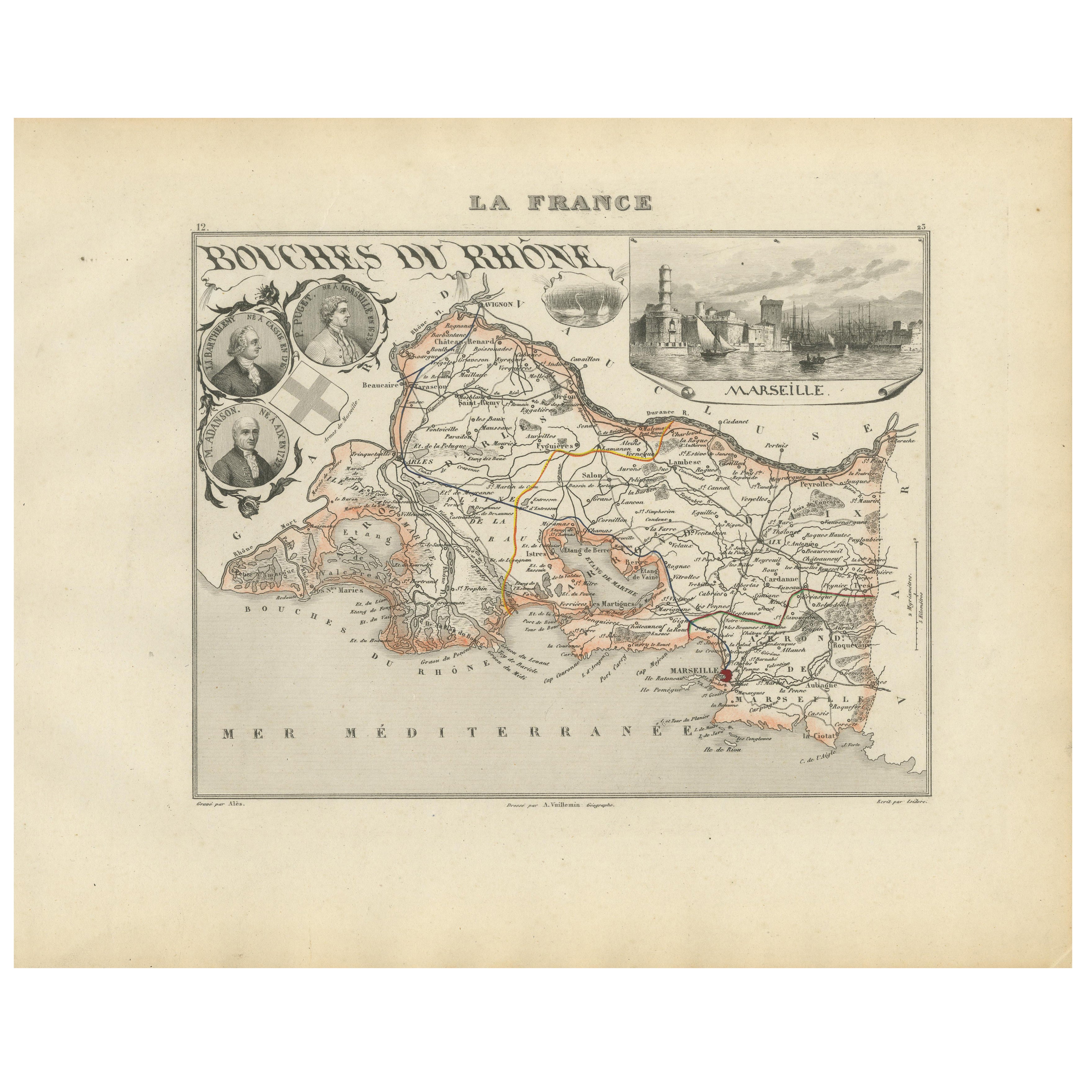
Map of Bouches-du-Rhône France with Marseille and Rhône Delta, 19th Century
Located in Langweer, NL
Map of Bouches-du-Rhône France with Marseille and Rhône Delta, 19th Century
Description:
This finely engraved 19th-century map of the Bouches-du-Rhône department in southeastern Fra...
Category
Antique Mid-19th Century French Maps
Materials
Paper
Map of Côtes-du-Nord France with Saint-Brieuc and Brittany Coastline, c.1850
Located in Langweer, NL
Map of Côtes-du-Nord France with Saint-Brieuc and Brittany Coastline, 19th c
Description:
This elegant 19th-century map of Côtes-du-Nord, the historic name for what is now known as ...
Category
Antique Mid-19th Century French Maps
Materials
Paper

Map of Côte-d'Or France with Dijon and Burgundy Wine Region, 19th Century
Located in Langweer, NL
Map of Côte-d'Or France with Dijon and Burgundy Wine Region, 19th Century
Description:
This beautifully engraved 19th-century map of Côte-d'Or, located in the historic region of Bur...
Category
Antique Mid-19th Century French Maps
Materials
Paper

Map of Aisne France with Soissons and Champagne Vineyards by Vuillemin, 19th c
Located in Langweer, NL
Map of Aisne France with Soissons and Champagne Vineyards by Vuillemin, 19th c
Description:
This richly detailed 19th-century engraved and hand-colored map of the department of Aisn...
Category
Antique Mid-19th Century French Maps
Materials
Paper

Map of Ariège France with Foix and Pyrenees Landscape by Vuillemin, 19th c
Located in Langweer, NL
Map of Ariège France with Foix and Pyrenees Landscape by Vuillemin, 19th c
Description:
This beautifully detailed 19th-century map of the Ariège department in southwestern France wa...
Category
Antique Mid-19th Century French Maps
Materials
Paper

You May Also Like
Large 19th Century Map of France
Located in Pease pottage, West Sussex
Large 19th Century Map of France.
Remarkable condition, with a pleasing age worn patina.
Recently framed.
France Circa 1874.
Category
Antique Late 19th Century French Maps
Materials
Linen, Paper

Map of Haute Vienne - Original Lithograph - 19th Century
Located in Roma, IT
Map of Haute Vienne is an original lithograph artwork realized by an Anonymous engraver of the 19th century.
Printed in the series of "France Pittoresque".
Titled "France Pittore...
Category
19th Century Modern Figurative Prints
Materials
Lithograph

L'Isere, France. Antique map of French department, 1856
By Victor Levasseur
Located in Melbourne, Victoria
'Dept. de L'Isere', Steel engraving with original outline hand-colouring., 1856, from Levasseur's 'Atlas National Illustre'.
This area is known for its production of Bleu du Vercor...
Category
19th Century Naturalistic Landscape Prints
Materials
Engraving

France, Northern Part. Century Atlas antique map
Located in Melbourne, Victoria
'The Century Atlas. France, Northern Part.'
Original antique map, 1903.
Inset maps of 'France in Provinces' and 'Paris and Vicinity'.
Central fold as issued. Map name and number pr...
Category
Early 20th Century Victorian More Prints
Materials
Lithograph

Map of Rhône - Original Etching - 19th Century
Located in Roma, IT
Map of Rhône is an original antique etching realized by an anonymous engraver of the 19th Century.
Printed in series of "France Pittoresque" at the top center.
The state of preserv...
Category
19th Century Modern Figurative Prints
Materials
Etching

Aude, France. Antique map of a French department, 1856
By Victor Levasseur
Located in Melbourne, Victoria
'Dept. de L' Aude', steel engraving with original outline hand-colouring., 1856, from Levasseur's 'Atlas National Illustre'.
This area of France is famous for its wide variety of v...
Category
19th Century Naturalistic Landscape Prints
Materials
Engraving

More Ways To Browse
French Wine Map
Mid Century Spices
Antique Wine Labels
Colored Wine Glass
Pink Wine Glass
French Walnut Oil
Dior Wine Glasses
Nouvel Glass
6x10 Rug
Styles Of Antique Desks
Black And White Coffee Table
Metal Relief
Curved Velvet Couch
Velvet Curved Sofa
Wood Round Coffee Tables
Antique Paper Flowers
Oak Brutalist
Used College Furniture