Items Similar to Map of Eure-et-Loir France with Chartres Cathedral and Marceau Portrait, c.1850


Want more images or videos?
Request additional images or videos from the seller
1 of 10
Map of Eure-et-Loir France with Chartres Cathedral and Marceau Portrait, c.1850
$167.74
£124.87
€140
CA$229.76
A$255.55
CHF 133.44
MX$3,109.72
NOK 1,704.21
SEK 1,598.24
DKK 1,065.77
Shipping
Retrieving quote...The 1stDibs Promise:
Authenticity Guarantee,
Money-Back Guarantee,
24-Hour Cancellation
About the Item
Map of Eure-et-Loir France with Chartres Cathedral and Marceau Portrait, 19th c
This detailed and elegantly illustrated 19th-century map of the Eure-et-Loir department in north-central France was drawn by Alexandre Vuillemin and published in Paris by Migeon as part of the *Nouvel Atlas Illustré*. Combining precise cartography with rich historical symbolism, the map captures the agricultural and cultural identity of a region closely tied to the history of the French monarchy and the Catholic Church.
Outlined in soft lilac hand-coloring, the map shows the full extent of Eure-et-Loir, including its road networks, towns, and rivers. The city of Chartres, the department’s capital, is prominently featured near the center. Other important towns such as Dreux, Nogent-le-Rotrou, and Châteaudun are also clearly marked, reflecting the region’s strategic position between Paris and the Loire Valley.
At the top right is a finely engraved portrait of General François-Séverin Marceau, a revolutionary army officer born in Chartres in 1769. His military legacy is commemorated through his prominent placement on the map. At the bottom, two vignettes feature striking views of the region’s medieval fortresses and ruined châteaux, offering a glimpse into its feudal and architectural past. One engraving is likely a view of the ruins near Châteaudun or Nogent-le-Rotrou, reinforcing the historical depth of the area.
Eure-et-Loir lies within the Beauce plain, one of the most productive agricultural areas in France, often referred to as the "granary of France" due to its vast wheat fields. Though not a major wine-producing department, the region is vital for its grain and livestock production and has a long ecclesiastical tradition. Chartres Cathedral, a UNESCO World Heritage site, is one of the most celebrated examples of Gothic architecture in Europe, known for its towering spires and remarkably preserved stained-glass windows.
This map is an ideal addition for collectors interested in French history, military heritage, or ecclesiastical art, offering both visual charm and regional significance.
Condition summary:
Very good condition with light age toning and minor foxing in the margins. The engraving remains sharp and the original hand coloring is well preserved.
Framing tips:
A dark walnut or black frame will emphasize the historical gravitas of this map. Pair it with an ivory or soft grey mat to enhance the coloring and support the Gothic architectural details. UV-protective glass is recommended for display and archival care.
- Dimensions:Height: 12.8 in (32.5 cm)Width: 10.28 in (26.1 cm)Depth: 0.01 in (0.2 mm)
- Materials and Techniques:Paper,Engraved
- Place of Origin:
- Period:
- Date of Manufacture:circa 1850
- Condition:Very good condition with light age toning and minor foxing in the margins. The engraving remains sharp and the original hand coloring is well preserved.
- Seller Location:Langweer, NL
- Reference Number:Seller: BG-13331-271stDibs: LU3054345363892
About the Seller
5.0
Recognized Seller
These prestigious sellers are industry leaders and represent the highest echelon for item quality and design.
Platinum Seller
Premium sellers with a 4.7+ rating and 24-hour response times
Established in 2009
1stDibs seller since 2017
2,510 sales on 1stDibs
Typical response time: <1 hour
- ShippingRetrieving quote...Shipping from: Langweer, Netherlands
- Return Policy
Authenticity Guarantee
In the unlikely event there’s an issue with an item’s authenticity, contact us within 1 year for a full refund. DetailsMoney-Back Guarantee
If your item is not as described, is damaged in transit, or does not arrive, contact us within 7 days for a full refund. Details24-Hour Cancellation
You have a 24-hour grace period in which to reconsider your purchase, with no questions asked.Vetted Professional Sellers
Our world-class sellers must adhere to strict standards for service and quality, maintaining the integrity of our listings.Price-Match Guarantee
If you find that a seller listed the same item for a lower price elsewhere, we’ll match it.Trusted Global Delivery
Our best-in-class carrier network provides specialized shipping options worldwide, including custom delivery.More From This Seller
View AllMap of Côtes-du-Nord France with Saint-Brieuc and Brittany Coastline, c.1850
Located in Langweer, NL
Map of Côtes-du-Nord France with Saint-Brieuc and Brittany Coastline, 19th c
Description:
This elegant 19th-century map of Côtes-du-Nord, the historic name for what is now known as ...
Category
Antique Mid-19th Century French Maps
Materials
Paper

Map of Eure France with Evreux, Poussin and Normandy Countryside, 19th Century
Located in Langweer, NL
Map of Eure France with Evreux, Poussin and Normandy Countryside, 19th Century
Description:
This 19th-century engraved map of the Eure department in the Normandy region of northern ...
Category
Antique Mid-19th Century French Maps
Materials
Paper
Map of Allier France with Saint-Pourçain Wine Region by Vuillemin, 19th c
Located in Langweer, NL
Map of Allier France with Saint-Pourçain Wine Region by Vuillemin, 19th c
This decorative 19th-century map of Allier, a central department of France, comes from the celebrated Nouve...
Category
Antique Mid-19th Century French Maps
Materials
Paper

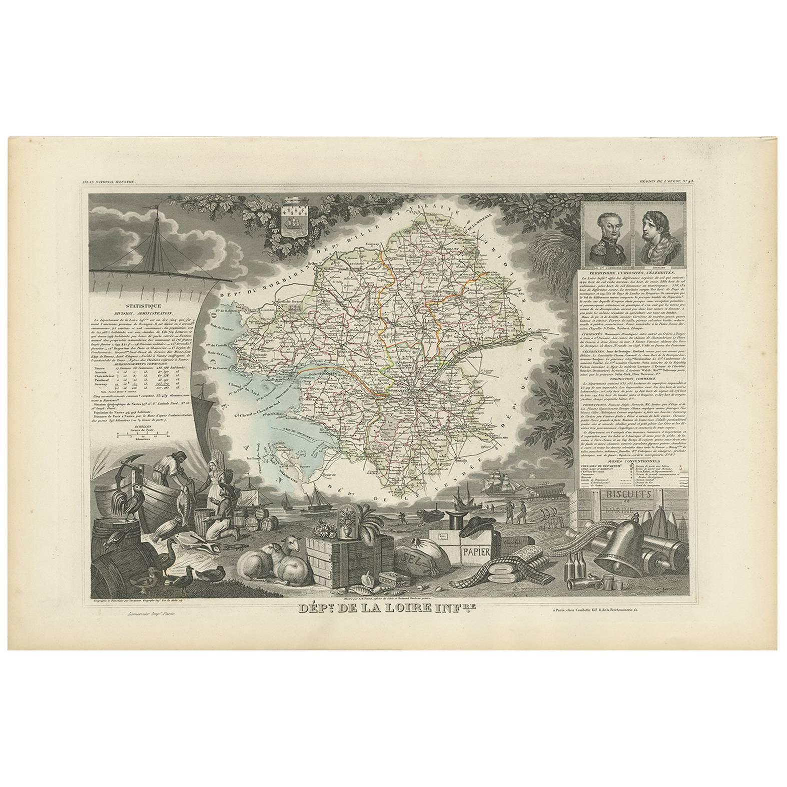
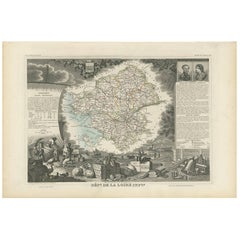
Antique Map of Loire Inferieure ‘France’ by V. Levasseur, 1854
Located in Langweer, NL
Antique map titled 'Dépt. de la Loire Inferieure'. Map of the French department of Loire Inferieure, France (currently known as Loire-Atlantique.) This area of France is part of the ...
Category
Antique Mid-19th Century Maps
Materials
Paper
$191 Sale Price
20% Off
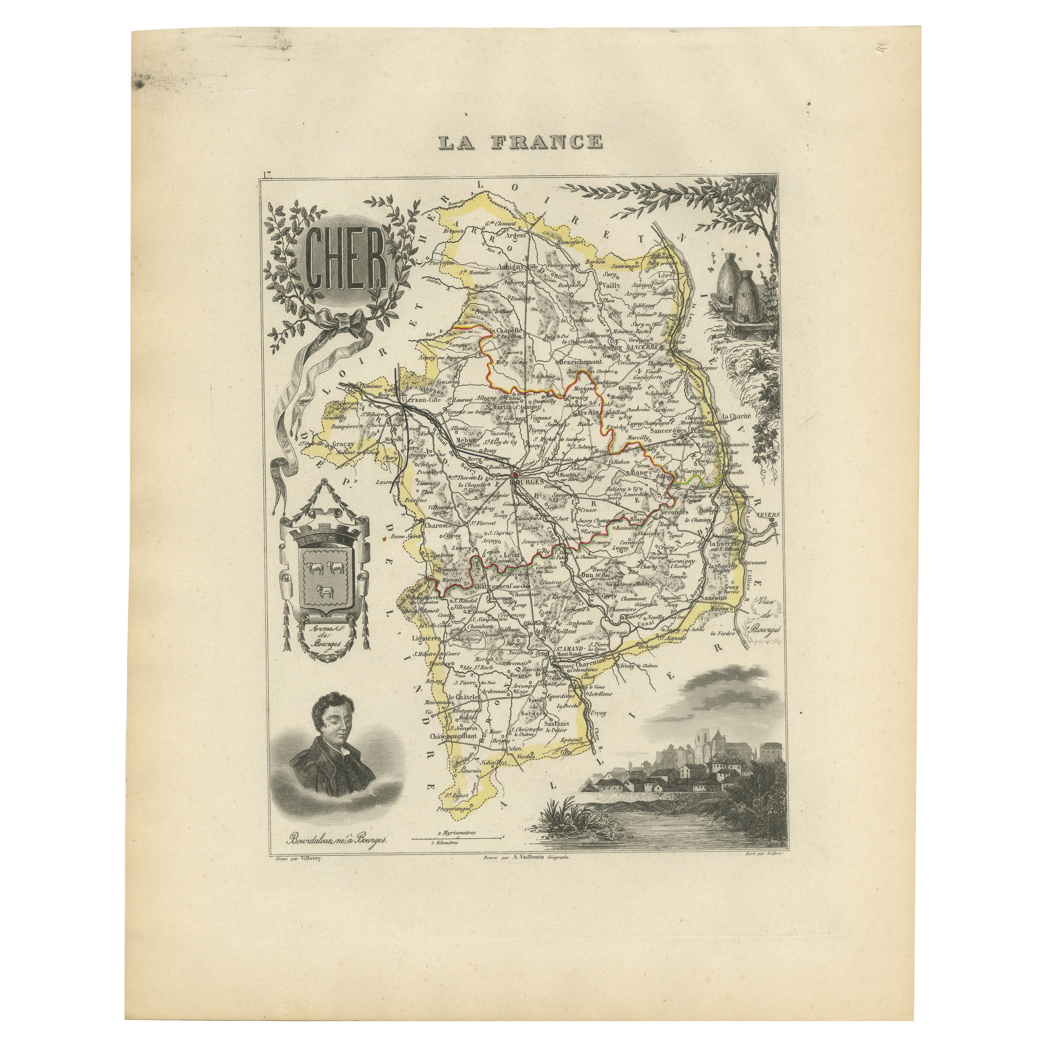
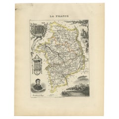
Map of Cher France with Bourges, Sancerre Vineyards and Engraved Vignettes, 1850
Located in Langweer, NL
Map of Charente-Inférieure France with La Rochelle and Coastal Vineyards, 19th c
Description:
This decorative 19th-century map of the former department of Charente-Inférieure, now k...
Category
Antique Mid-19th Century French Maps
Materials
Paper
Map of Charente France with Cognac Region and Château de La Rochefoucauld, 1850
Located in Langweer, NL
Map of Charente France with Cognac Region and Château de La Rochefoucauld, 19th c
Description:
This richly illustrated 19th-century map of the Charente department in southwestern Fr...
Category
Antique Mid-19th Century French Maps
Materials
Paper

You May Also Like
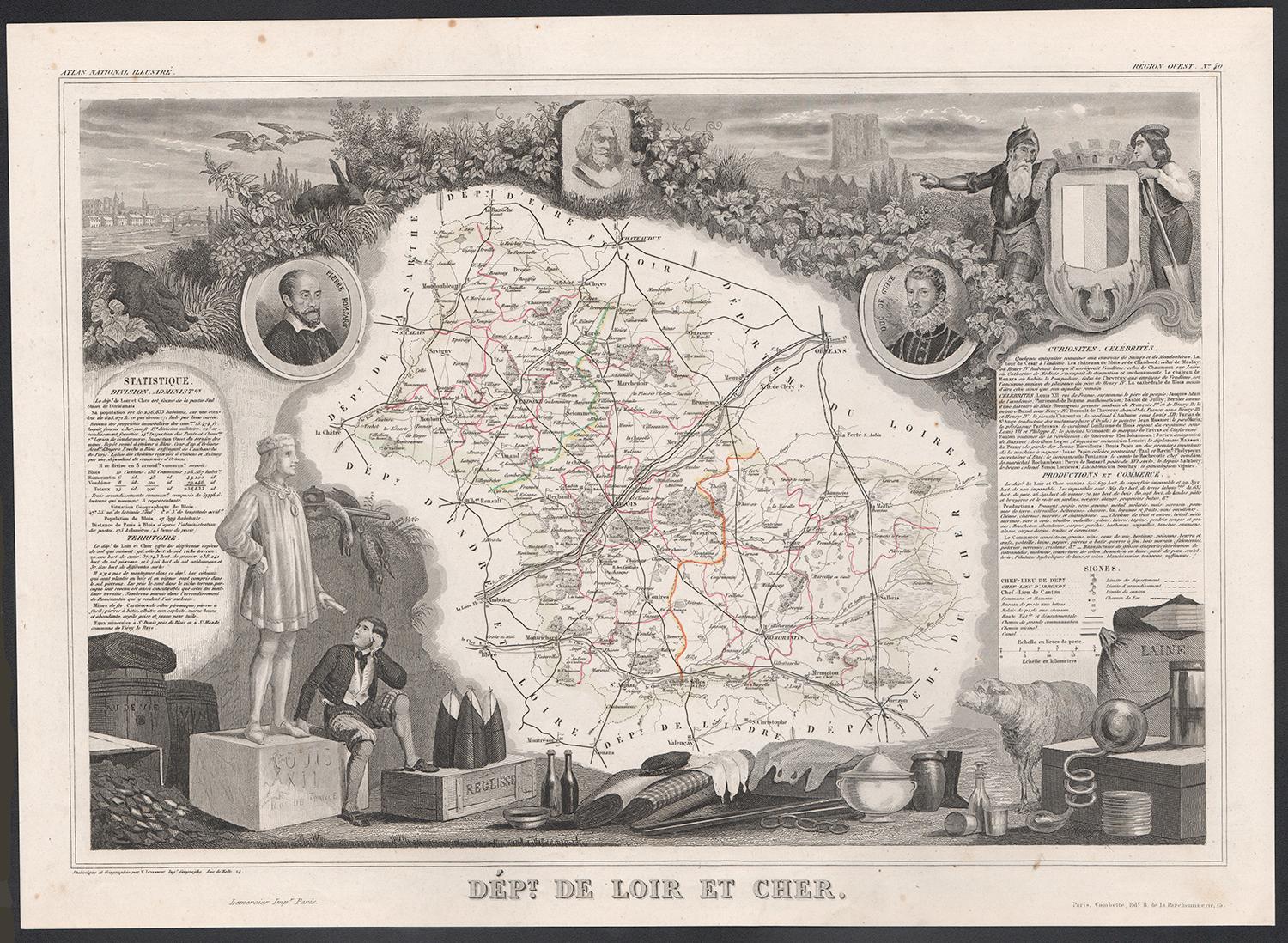
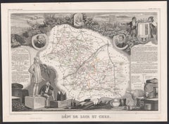
Loir and Cher, France. Antique map of a French department, 1856
By Victor Levasseur
Located in Melbourne, Victoria
'Dept. de Loir and Cher', steel engraving with original outline hand-colouring., 1856, from Levasseur's Atlas National Illustre.
This area is mainly known for its production of Sel...
Category
19th Century Naturalistic Landscape Prints
Materials
Engraving
Saone and Loire, France. Antique map of a French department, 1856
By Victor Levasseur
Located in Melbourne, Victoria
'Dept. de Saone et Loire', steel engraving with original outline hand-colouring., 1856, from Levasseur's Atlas National Illustre.
The French department of Saone et Loire is at the ...
Category
19th Century Naturalistic Landscape Prints
Materials
Engraving

Indre and Loire, France. Antique map of a French department, 1856
By Victor Levasseur
Located in Melbourne, Victoria
'Dept. d'Indre et Loire', steel engraving with original outline hand-colouring., 1856, from Levasseur's 'Atlas National Illustre'.
This area is known for its production of Chenin b...
Category
19th Century Naturalistic Landscape Prints
Materials
Engraving

Aube, France. Antique map of a French department, 1856
By Victor Levasseur
Located in Melbourne, Victoria
'Dept. de L'Aube', steel engraving with original outline hand-colouring., 1856, from Levasseur's 'Atlas National Illustre'.
This area of France is known for its production of Chaou...
Category
19th Century Naturalistic Landscape Prints
Materials
Engraving

L'Isere, France. Antique map of French department, 1856
By Victor Levasseur
Located in Melbourne, Victoria
'Dept. de L'Isere', Steel engraving with original outline hand-colouring., 1856, from Levasseur's 'Atlas National Illustre'.
This area is known for its production of Bleu du Vercor...
Category
19th Century Naturalistic Landscape Prints
Materials
Engraving

Aude, France. Antique map of a French department, 1856
By Victor Levasseur
Located in Melbourne, Victoria
'Dept. de L' Aude', steel engraving with original outline hand-colouring., 1856, from Levasseur's 'Atlas National Illustre'.
This area of France is famous for its wide variety of v...
Category
19th Century Naturalistic Landscape Prints
Materials
Engraving

More Ways To Browse
Antique Ivory Collectables
Ecclesiastical Art
Antique Cathedral Glass
French Wine Map
Gothic Engraving
Gothic Spire
Gothic Window Frame
Nouvel Glass
6x10 Rug
Styles Of Antique Desks
Black And White Coffee Table
Metal Relief
Curved Velvet Couch
Velvet Curved Sofa
Wood Round Coffee Tables
Antique Paper Flowers
Oak Brutalist
Used College Furniture