Items Similar to Map of Eure France with Evreux, Poussin and Normandy Countryside, 19th Century


Want more images or videos?
Request additional images or videos from the seller
1 of 10
Map of Eure France with Evreux, Poussin and Normandy Countryside, 19th Century
$167.89
£124.89
€140
CA$229.89
A$255.61
CHF 133.46
MX$3,111.38
NOK 1,702.95
SEK 1,595.58
DKK 1,065.74
Shipping
Retrieving quote...The 1stDibs Promise:
Authenticity Guarantee,
Money-Back Guarantee,
24-Hour Cancellation
About the Item
Map of Eure France with Evreux, Poussin and Normandy Countryside, 19th Century
Description:
This 19th-century engraved map of the Eure department in the Normandy region of northern France was drawn by Alexandre Vuillemin and published by Migeon in Paris as part of the *Nouvel Atlas Illustré*. The map combines detailed geographic representation with classical decorative flourishes, offering a glimpse into the cultural and natural heritage of this part of France.
The borders of Eure are highlighted in soft blue hand coloring, with all major towns, rivers, roads, and administrative boundaries carefully engraved. Evreux, the departmental capital, is prominently featured near the center, while other towns such as Vernon, Louviers, Les Andelys, and Bernay are clearly labeled. The river Seine winds through the northeastern section, reflecting Eure’s strategic importance as part of the greater Paris-to-Le Havre corridor.
At the lower left is a charming vignette of Evreux, with its cathedral rising above the townscape. A portrait of the 17th-century painter Nicolas Poussin appears in the upper left, celebrating one of France’s greatest classical artists who was born near Les Andelys in Eure. The upper right corner features the departmental coat of arms with a fleur-de-lis and decorative flourishes. The lower edge includes a pastoral landscape evoking the Normandy countryside.
Eure, part of historic Normandy, has long been known for its fertile farmland, riverside villages, and forested areas. Though not a principal wine region, it is deeply associated with apple orchards and cider production, as well as dairy farming and cheese making. Its proximity to Paris and Rouen historically made it an important supplier of agricultural products. Architecturally, the region is rich in Romanesque and Gothic churches, châteaux, and the ruins of medieval fortresses.
This map is a wonderful example of decorative French cartography, rich in both geographical detail and cultural references. It appeals to collectors with interests in Normandy, French regional history, or antique engravings with artistic flair.
Condition summary:
Very good antique condition. Minor foxing and slight toning mostly confined to the outer margins. Engraved detail is crisp and the hand coloring remains clear and intact.
Framing tips:
Best suited to a medium oak or black frame. Pair with a neutral cream or pale blue mat to complement the soft border coloring and engraved vignettes. Use UV-protective glass to preserve the print and enhance clarity.
- Dimensions:Height: 10.28 in (26.1 cm)Width: 12.8 in (32.5 cm)Depth: 0.01 in (0.2 mm)
- Materials and Techniques:Paper,Engraved
- Place of Origin:
- Period:
- Date of Manufacture:circa 1850
- Condition:Very good antique condition. Minor foxing and slight toning mostly confined to the outer margins. Engraved detail is crisp and the hand coloring remains clear and intact.
- Seller Location:Langweer, NL
- Reference Number:Seller: BG-13331-261stDibs: LU3054345363882
About the Seller
5.0
Recognized Seller
These prestigious sellers are industry leaders and represent the highest echelon for item quality and design.
Platinum Seller
Premium sellers with a 4.7+ rating and 24-hour response times
Established in 2009
1stDibs seller since 2017
2,510 sales on 1stDibs
Typical response time: <1 hour
- ShippingRetrieving quote...Shipping from: Langweer, Netherlands
- Return Policy
Authenticity Guarantee
In the unlikely event there’s an issue with an item’s authenticity, contact us within 1 year for a full refund. DetailsMoney-Back Guarantee
If your item is not as described, is damaged in transit, or does not arrive, contact us within 7 days for a full refund. Details24-Hour Cancellation
You have a 24-hour grace period in which to reconsider your purchase, with no questions asked.Vetted Professional Sellers
Our world-class sellers must adhere to strict standards for service and quality, maintaining the integrity of our listings.Price-Match Guarantee
If you find that a seller listed the same item for a lower price elsewhere, we’ll match it.Trusted Global Delivery
Our best-in-class carrier network provides specialized shipping options worldwide, including custom delivery.More From This Seller
View AllMap of Aube France with Troyes and Champagne Wine Region, 19th Century
Located in Langweer, NL
Map of Aube France with Troyes and Champagne Vineyards by Vuillemin, 19th c
Description:
This 19th-century map of the Aube department in the Grand Est region of northeastern France ...
Category
Antique Mid-19th Century French Maps
Materials
Paper

Map of Aude France with Carcassonne and Languedoc Vineyards, 19th Century
Located in Langweer, NL
Map of Aude France with Carcassonne and Languedoc Vineyards, 19th Century
Description:
This elegant 19th-century map of Aude, a department in southern France along the Mediterranean...
Category
Antique Mid-19th Century French Maps
Materials
Paper

Map of Côtes-du-Nord France with Saint-Brieuc and Brittany Coastline, c.1850
Located in Langweer, NL
Map of Côtes-du-Nord France with Saint-Brieuc and Brittany Coastline, 19th c
Description:
This elegant 19th-century map of Côtes-du-Nord, the historic name for what is now known as ...
Category
Antique Mid-19th Century French Maps
Materials
Paper

Map of Allier France with Saint-Pourçain Wine Region by Vuillemin, 19th c
Located in Langweer, NL
Map of Allier France with Saint-Pourçain Wine Region by Vuillemin, 19th c
This decorative 19th-century map of Allier, a central department of France, comes from the celebrated Nouve...
Category
Antique Mid-19th Century French Maps
Materials
Paper

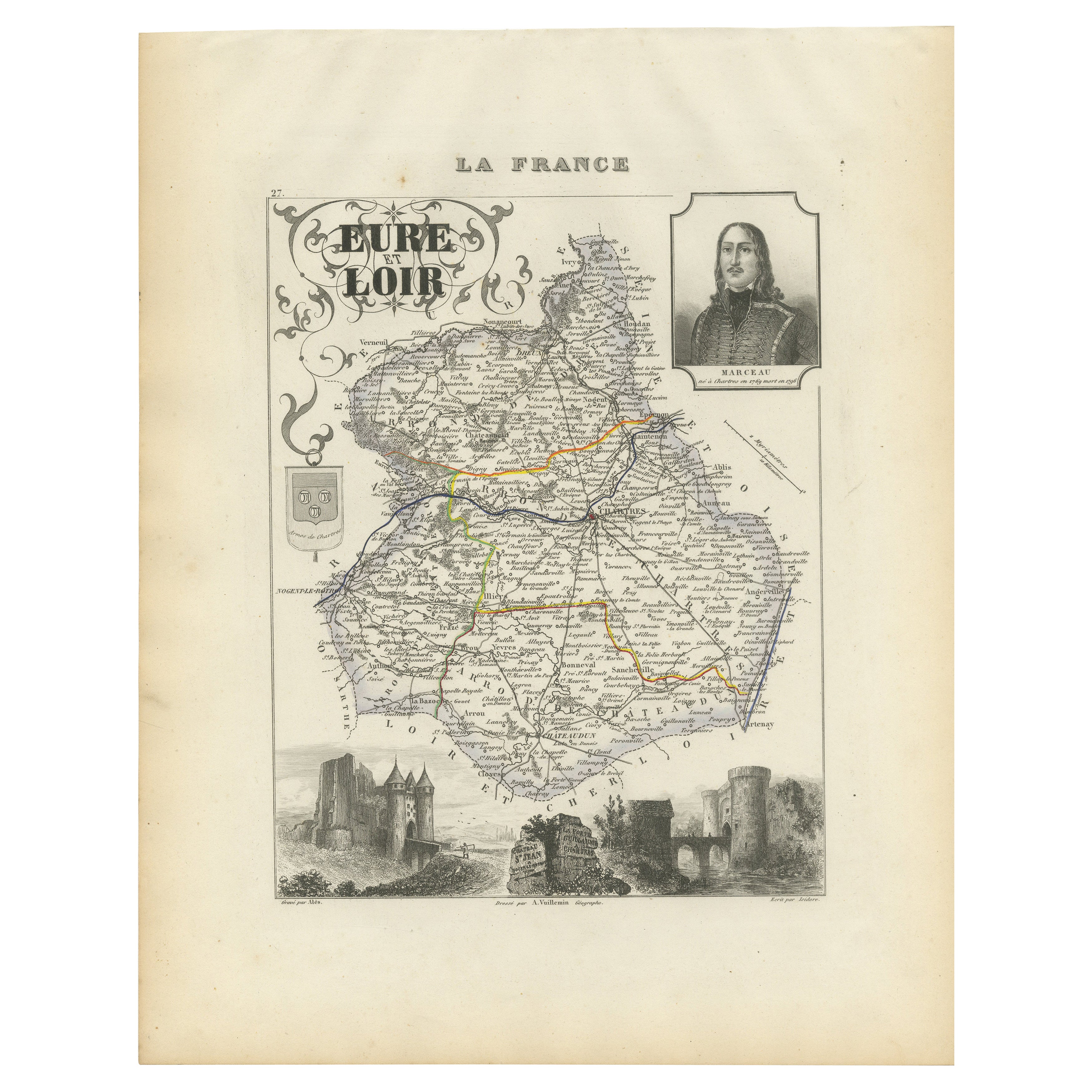
Map of Eure-et-Loir France with Chartres Cathedral and Marceau Portrait, c.1850
Located in Langweer, NL
Map of Eure-et-Loir France with Chartres Cathedral and Marceau Portrait, 19th c
This detailed and elegantly illustrated 19th-century map of the Eure-et-Loir department in north-cent...
Category
Antique Mid-19th Century French Maps
Materials
Paper
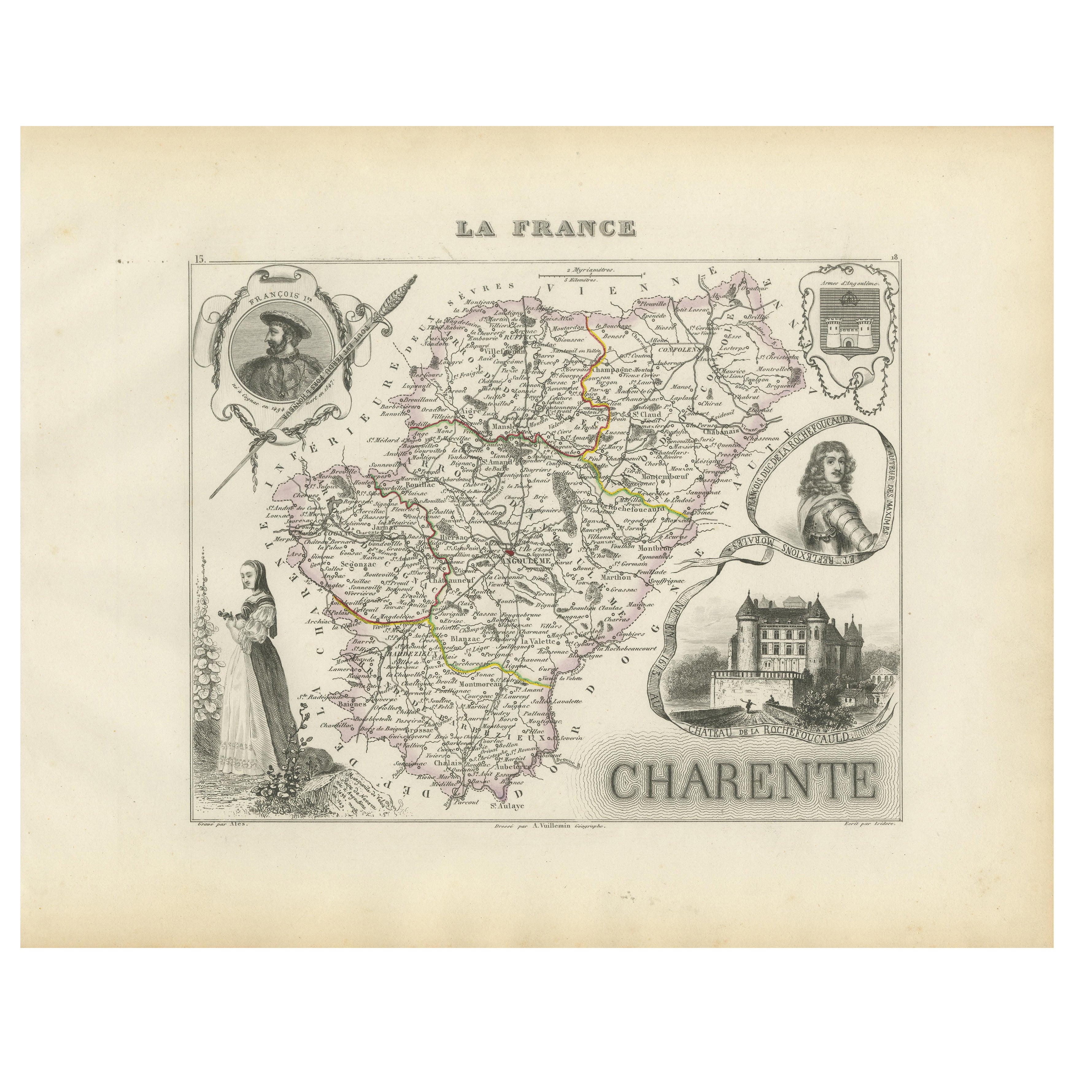
Map of Charente France with Cognac Region and Château de La Rochefoucauld, 1850
Located in Langweer, NL
Map of Charente France with Cognac Region and Château de La Rochefoucauld, 19th c
Description:
This richly illustrated 19th-century map of the Charente department in southwestern Fr...
Category
Antique Mid-19th Century French Maps
Materials
Paper

You May Also Like
Aube, France. Antique map of a French department, 1856
By Victor Levasseur
Located in Melbourne, Victoria
'Dept. de L'Aube', steel engraving with original outline hand-colouring., 1856, from Levasseur's 'Atlas National Illustre'.
This area of France is known for its production of Chaou...
Category
19th Century Naturalistic Landscape Prints
Materials
Engraving

Aude, France. Antique map of a French department, 1856
By Victor Levasseur
Located in Melbourne, Victoria
'Dept. de L' Aude', steel engraving with original outline hand-colouring., 1856, from Levasseur's 'Atlas National Illustre'.
This area of France is famous for its wide variety of v...
Category
19th Century Naturalistic Landscape Prints
Materials
Engraving

Indre and Loire, France. Antique map of a French department, 1856
By Victor Levasseur
Located in Melbourne, Victoria
'Dept. d'Indre et Loire', steel engraving with original outline hand-colouring., 1856, from Levasseur's 'Atlas National Illustre'.
This area is known for its production of Chenin b...
Category
19th Century Naturalistic Landscape Prints
Materials
Engraving

Saone and Loire, France. Antique map of a French department, 1856
By Victor Levasseur
Located in Melbourne, Victoria
'Dept. de Saone et Loire', steel engraving with original outline hand-colouring., 1856, from Levasseur's Atlas National Illustre.
The French department of Saone et Loire is at the ...
Category
19th Century Naturalistic Landscape Prints
Materials
Engraving

Lozere, France. Antique map of a French department, 1856
By Victor Levasseur
Located in Melbourne, Victoria
'Dept. de La Lozere', steel engraving with original outline hand-colouring., 1856, from Levasseur's 'Atlas National Illustre'.
This remote mountainous part of Languedoc is rural, s...
Category
19th Century Naturalistic Landscape Prints
Materials
Engraving

Large 19th Century Map of France
Located in Pease pottage, West Sussex
Large 19th Century Map of France.
Remarkable condition, with a pleasing age worn patina.
Recently framed.
France Circa 1874.
Category
Antique Late 19th Century French Maps
Materials
Linen, Paper

More Ways To Browse
Antique Village Soft
Antique Rouen
Antique Cathedral Glass
Riverside Furniture
French Wine Map
Wine 17th
Gothic Engraving
Antique Wine Labels
Used Furniture Vernon
17th Century Wine Glasses
Nouvel Glass
6x10 Rug
Styles Of Antique Desks
Black And White Coffee Table
Metal Relief
Curved Velvet Couch
Velvet Curved Sofa
Wood Round Coffee Tables