Items Similar to Map of Haute-Garonne France with Toulouse and Garonne River by Vuillemin, c.1850


Want more images or videos?
Request additional images or videos from the seller
1 of 10
Map of Haute-Garonne France with Toulouse and Garonne River by Vuillemin, c.1850
$167.89
£124.89
€140
CA$229.89
A$255.61
CHF 133.46
MX$3,111.38
NOK 1,702.95
SEK 1,595.58
DKK 1,065.74
Shipping
Retrieving quote...The 1stDibs Promise:
Authenticity Guarantee,
Money-Back Guarantee,
24-Hour Cancellation
About the Item
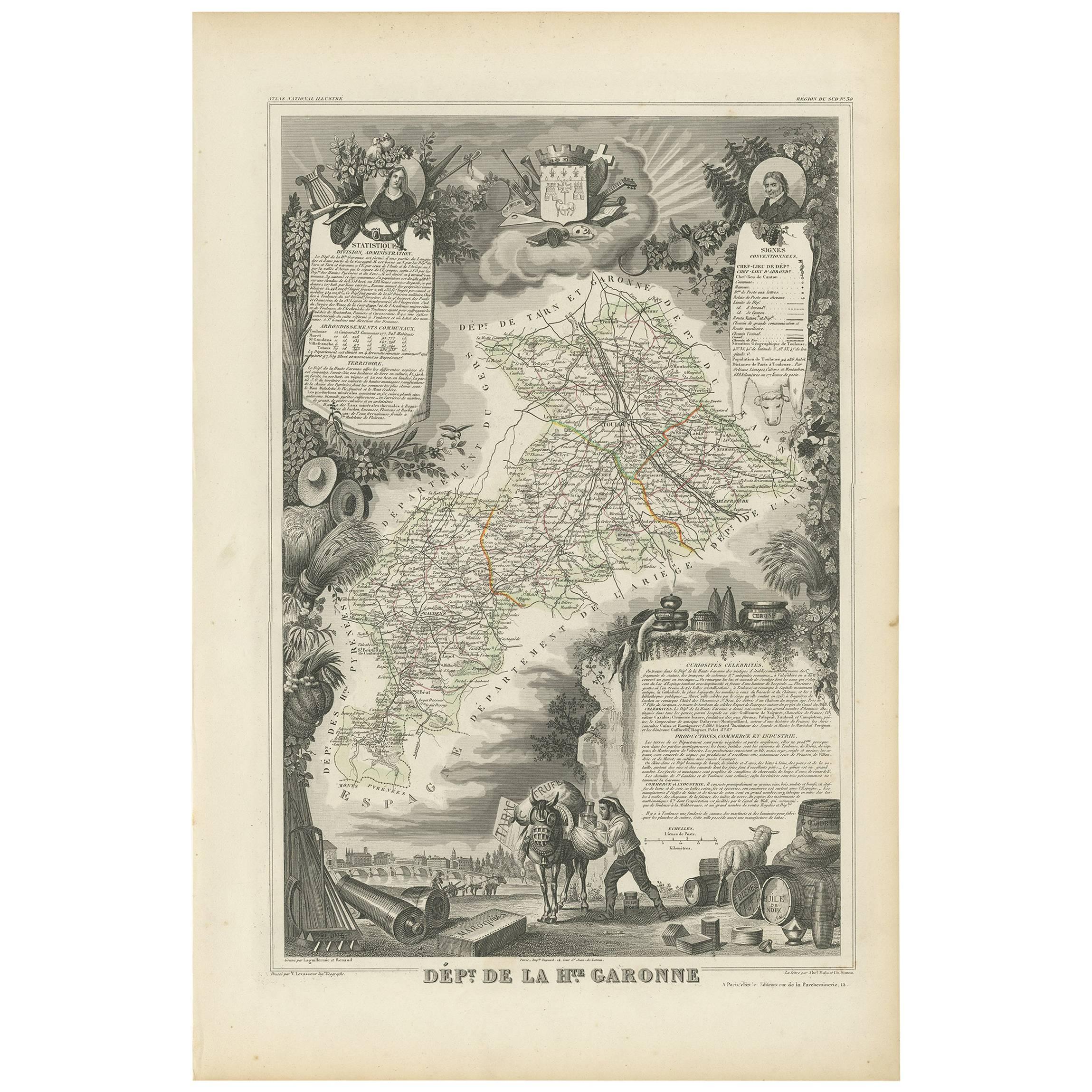
Map of Haute-Garonne France with Toulouse and Garonne River by Vuillemin, 19th c
Description:
This finely engraved 19th-century map of the department of Haute-Garonne, located in southwestern France, is part of Alexandre Vuillemin’s *Nouvel Atlas Illustré*, published in Paris by Migeon. The map presents a detailed view of the region’s topography and settlements, enriched by charming vignettes and portraits that highlight its cultural and historical importance.
Haute-Garonne is situated in the Occitanie region and is named after the Garonne River, which flows through the department’s capital, Toulouse. The map displays the area’s borders in soft hand-applied pink, and meticulously marks rivers, roads, and towns. Toulouse is prominently featured at the center, reflecting its status as the economic and cultural heart of the department.
The map is visually enriched with several artistic details. At the lower right, an attractive vignette shows the city of Toulouse with the Garonne River and a stone bridge—likely the Pont Neuf—connecting the historic parts of the city. At the top right, a portrait of the Abbé Sicard, a notable educator and pioneer in teaching the deaf, pays homage to one of the region’s historical figures. On the left side, a costumed couple with an ox—representing regional dress and agricultural heritage—adds a folkloric touch. The department's coat of arms is also included, further underscoring its civic identity.
Haute-Garonne is part of the greater Sud-Ouest wine region of France. Though better known today for its high-tech industry centered in Toulouse, the department still has a presence in viticulture. Local wines fall under the Comté Tolosan IGP label, and grape varieties such as Merlot, Cabernet Franc, and Tannat are grown in nearby areas. The region’s climate—characterized by warm summers and cool winters—supports a variety of wine styles, from red to white and rosé.
Alexandre Vuillemin was a noted 19th-century French cartographer who brought artistry and clarity to geographical publishing. His maps, engraved with great precision and often accompanied by cultural illustrations, were widely admired and collected. Publisher Migeon specialized in quality illustrated atlases that served both educational and decorative purposes.
Condition summary:
Very good condition with mild age toning and a few faint foxing spots near the edges. The engraved detail is crisp and the hand coloring remains clean and vivid.
Framing tips:
Best displayed in a natural wood or black frame to enhance the contrast of the engraving. A cream or soft rose-tinted mat will pair well with the pink border. Use UV-protective glass to preserve the fine detail and coloring.
- Dimensions:Height: 10.28 in (26.1 cm)Width: 12.8 in (32.5 cm)Depth: 0.01 in (0.2 mm)
- Materials and Techniques:Paper,Engraved
- Place of Origin:
- Period:
- Date of Manufacture:circa 1850
- Condition:Very good condition with mild age toning and a few faint foxing spots near the edges. The engraved detail is crisp and the hand coloring remains clean and vivid.
- Seller Location:Langweer, NL
- Reference Number:Seller: BG-13331-301stDibs: LU3054345363932
About the Seller
5.0
Recognized Seller
These prestigious sellers are industry leaders and represent the highest echelon for item quality and design.
Platinum Seller
Premium sellers with a 4.7+ rating and 24-hour response times
Established in 2009
1stDibs seller since 2017
2,510 sales on 1stDibs
Typical response time: <1 hour
- ShippingRetrieving quote...Shipping from: Langweer, Netherlands
- Return Policy
Authenticity Guarantee
In the unlikely event there’s an issue with an item’s authenticity, contact us within 1 year for a full refund. DetailsMoney-Back Guarantee
If your item is not as described, is damaged in transit, or does not arrive, contact us within 7 days for a full refund. Details24-Hour Cancellation
You have a 24-hour grace period in which to reconsider your purchase, with no questions asked.Vetted Professional Sellers
Our world-class sellers must adhere to strict standards for service and quality, maintaining the integrity of our listings.Price-Match Guarantee
If you find that a seller listed the same item for a lower price elsewhere, we’ll match it.Trusted Global Delivery
Our best-in-class carrier network provides specialized shipping options worldwide, including custom delivery.More From This Seller
View AllAntique Map of Haute-Garonne ‘France’ by V. Levasseur, 1854
Located in Langweer, NL
Antique map titled 'Dépt. de la Hte. Garonne'. Map of the French department of Haute-Garonne, France. This area of France produces the delicious but lesser known Buzet wines, and ten...
Category
Antique Mid-19th Century Maps
Materials
Paper
$172 Sale Price
20% Off
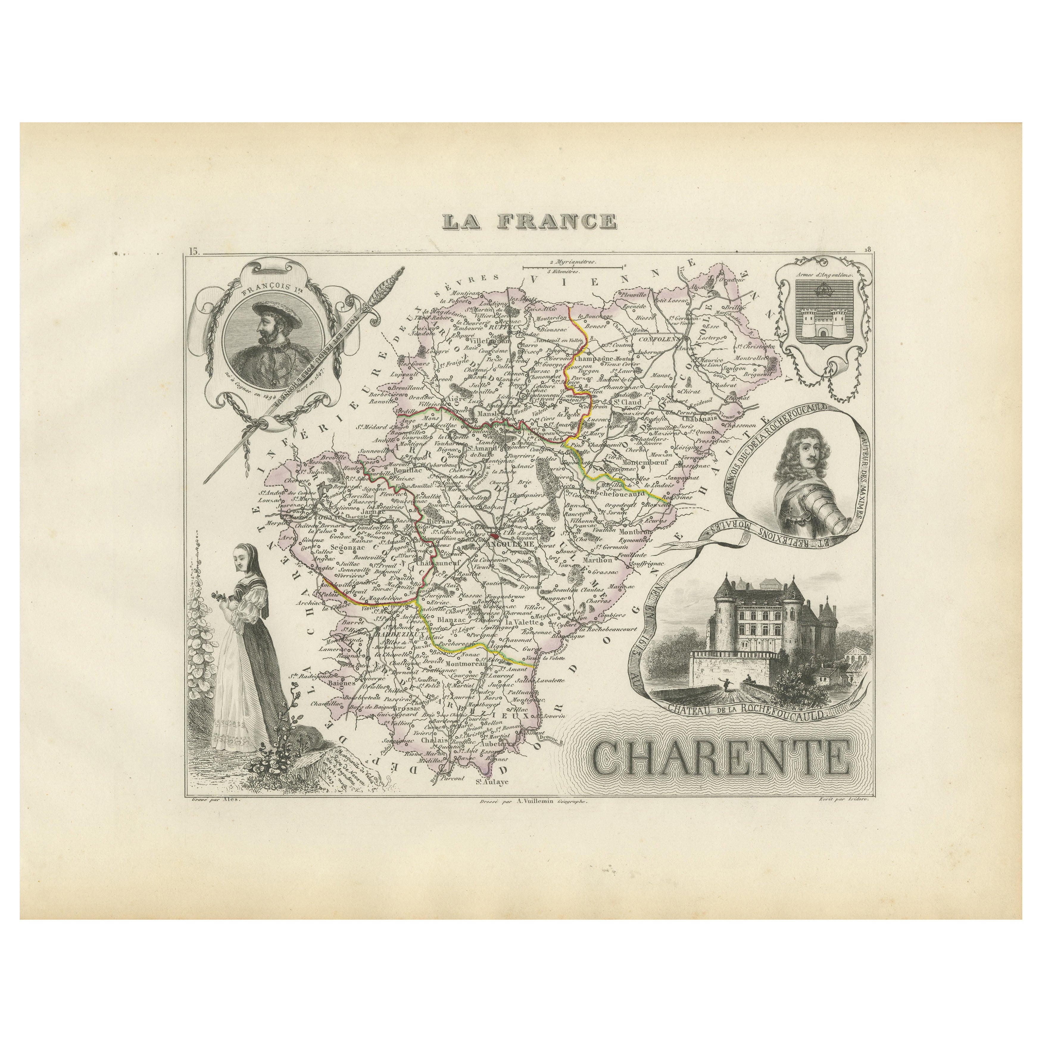
Map of Charente France with Cognac Region and Château de La Rochefoucauld, 1850
Located in Langweer, NL
Map of Charente France with Cognac Region and Château de La Rochefoucauld, 19th c
Description:
This richly illustrated 19th-century map of the Charente department in southwestern Fr...
Category
Antique Mid-19th Century French Maps
Materials
Paper

Map of Ariège France with Foix and Pyrenees Landscape by Vuillemin, 19th c
Located in Langweer, NL
Map of Ariège France with Foix and Pyrenees Landscape by Vuillemin, 19th c
Description:
This beautifully detailed 19th-century map of the Ariège department in southwestern France wa...
Category
Antique Mid-19th Century French Maps
Materials
Paper

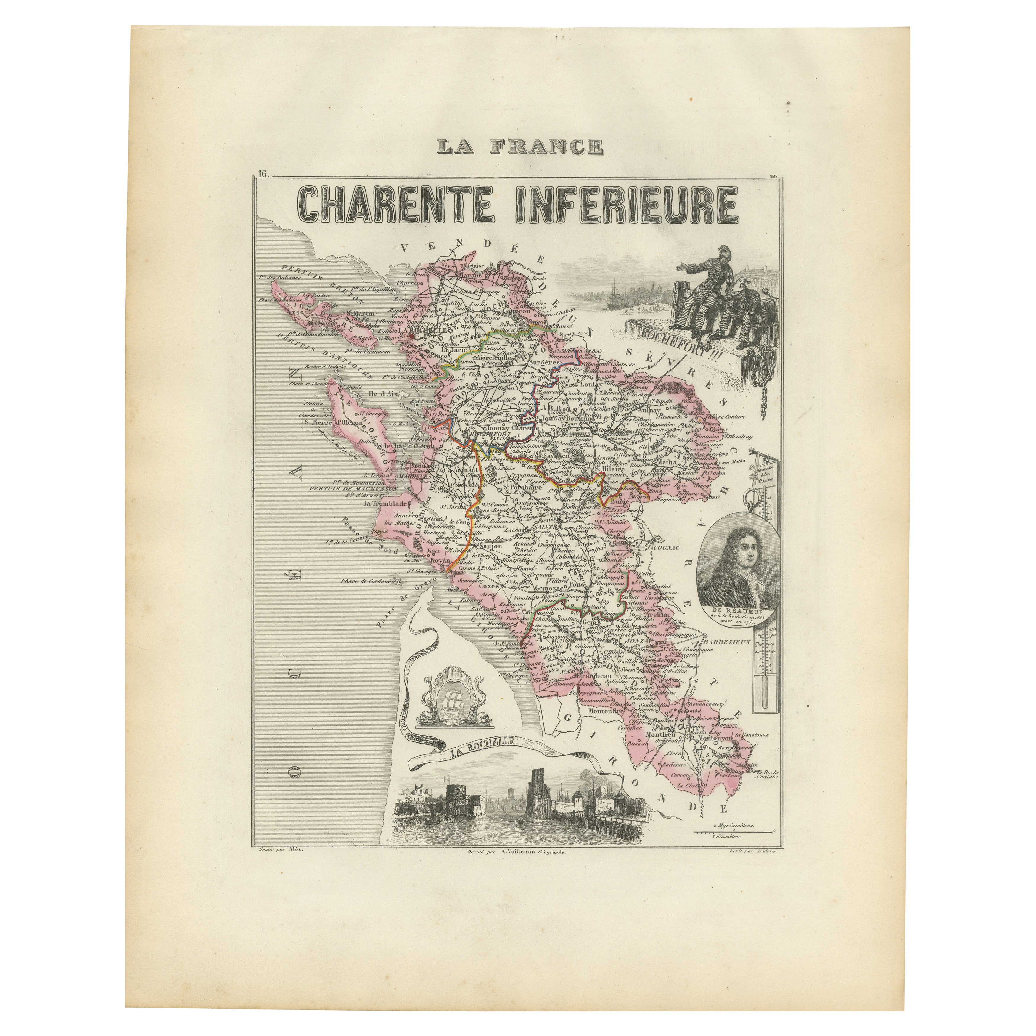
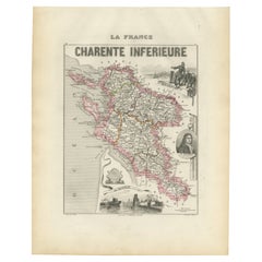
Map of Charente-Inférieure France with La Rochelle and Coastal Vineyards, c.1850
Located in Langweer, NL
Map of Charente-Inférieure France with La Rochelle and Coastal Vineyards, 19th c
Description:
This decorative 19th-century map of the former department of Charente-Inférieure, now k...
Category
Antique Mid-19th Century French Maps
Materials
Paper
Map of Gard France with Pont du Gard and Wine Regions by Vuillemin, 19th c
Located in Langweer, NL
Title: Map of Gard France with Pont du Gard and Wine Regions by Vuillemin, 19th c
Description:
This finely engraved 19th-century map of the department of Gard in southern France was...
Category
Antique Mid-19th Century French Maps
Materials
Paper

Map of Côtes-du-Nord France with Saint-Brieuc and Brittany Coastline, c.1850
Located in Langweer, NL
Map of Côtes-du-Nord France with Saint-Brieuc and Brittany Coastline, 19th c
Description:
This elegant 19th-century map of Côtes-du-Nord, the historic name for what is now known as ...
Category
Antique Mid-19th Century French Maps
Materials
Paper

You May Also Like
Saone and Loire, France. Antique map of a French department, 1856
By Victor Levasseur
Located in Melbourne, Victoria
'Dept. de Saone et Loire', steel engraving with original outline hand-colouring., 1856, from Levasseur's Atlas National Illustre.
The French department of Saone et Loire is at the ...
Category
19th Century Naturalistic Landscape Prints
Materials
Engraving

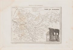
Tarn et Garonne Map - Original Lithograph - 19th Century
Located in Roma, IT
Tarn et Garonne Map is an original lithograph realized by an Anonymous artist of the 19th Century.
Printed in series of "France Pittoresque" at the top center.
The state of preservation of the artwork is good.
An interesting piece of art in this geographical map...
Category
19th Century Modern Figurative Prints
Materials
Paper, Lithograph
L'Herault, France. Antique map of a French department, 1856
By Victor Levasseur
Located in Melbourne, Victoria
'Dept. de Saone et Loire', steel engraving with original outline hand-colouring., 1856, from Levasseur's Atlas National Illustre.
This area is home to a wide variety of vineyards a...
Category
19th Century Naturalistic Landscape Prints
Materials
Engraving

L'Isere, France. Antique map of French department, 1856
By Victor Levasseur
Located in Melbourne, Victoria
'Dept. de L'Isere', Steel engraving with original outline hand-colouring., 1856, from Levasseur's 'Atlas National Illustre'.
This area is known for its production of Bleu du Vercor...
Category
19th Century Naturalistic Landscape Prints
Materials
Engraving

Aude, France. Antique map of a French department, 1856
By Victor Levasseur
Located in Melbourne, Victoria
'Dept. de L' Aude', steel engraving with original outline hand-colouring., 1856, from Levasseur's 'Atlas National Illustre'.
This area of France is famous for its wide variety of v...
Category
19th Century Naturalistic Landscape Prints
Materials
Engraving

Aube, France. Antique map of a French department, 1856
By Victor Levasseur
Located in Melbourne, Victoria
'Dept. de L'Aube', steel engraving with original outline hand-colouring., 1856, from Levasseur's 'Atlas National Illustre'.
This area of France is known for its production of Chaou...
Category
19th Century Naturalistic Landscape Prints
Materials
Engraving
