Items Similar to Map of Pescadores Islands (Pong-Hou) & Formosa – French Jesuit Engraving, 1790

Want more images or videos?
Request additional images or videos from the seller
1 of 10
Map of Pescadores Islands (Pong-Hou) & Formosa – French Jesuit Engraving, 1790
$402.98
£300.02
€340
CA$555.25
A$618.27
CHF 326.95
MX$7,523.91
NOK 4,121.32
SEK 3,882.89
DKK 2,588.26
About the Item
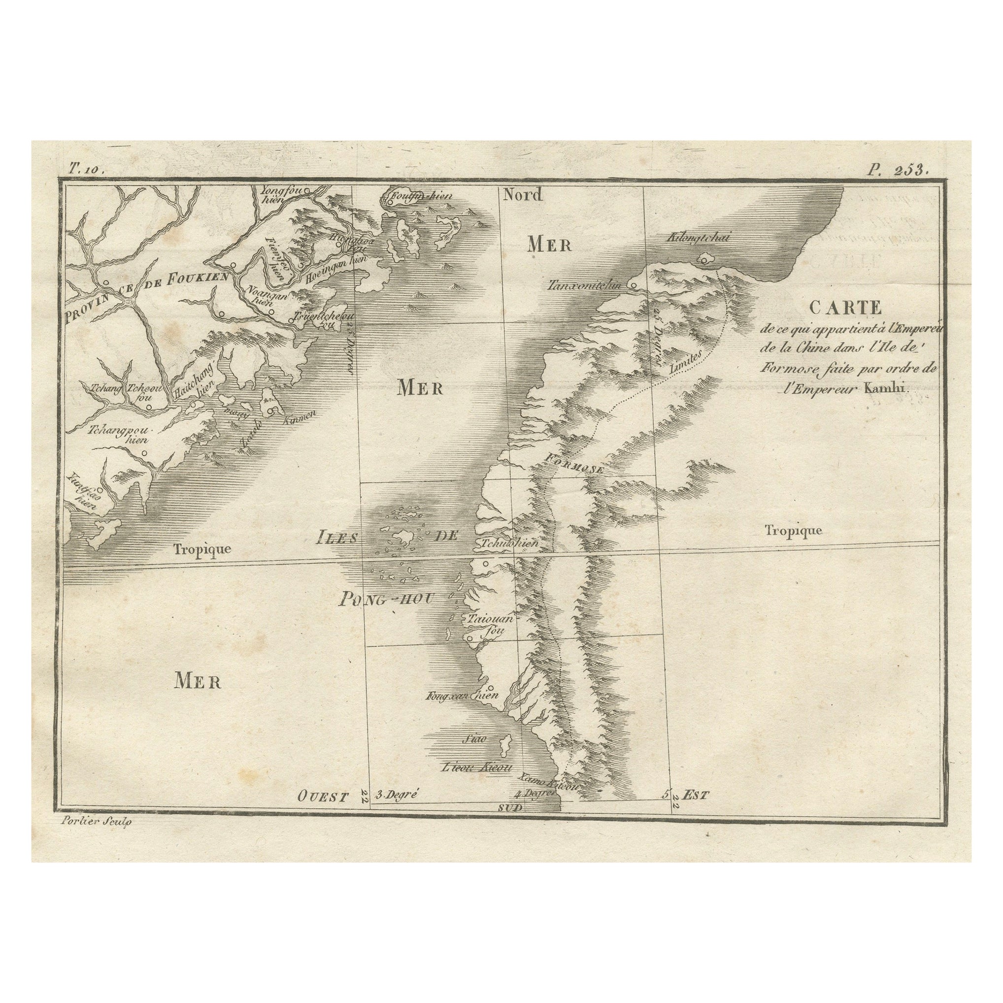
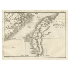
Map of the Pescadores Islands (Pong-Hou) and Formosa – French Jesuit Engraving by Portier, c.1790
This finely engraved French map, produced by Portier around 1790, depicts the Pescadores Islands (Iles de Pong-Hou) and part of the western coast of Formosa (modern Taiwan). The map is titled in French as “Carte des Isles de Pong-Hou suivant le point sur lequel ont été faites les Cartes de la Chine et de la Tartarie par l’ordre et aux frais de l’Empereur,” indicating that it was based on Chinese imperial surveys commissioned by the Emperor.
The Pescadores archipelago is shown in detail, with numerous islands labeled by their transliterated Chinese names, including Gonochou, Stehko yu, Kilong yu, Teou yu, Tetchou yu, and Paoaning yu. The western coast of Taiwan features key settlements and natural features, such as Makakeou, Kiailao, and the mountainous interior, labeled “Montagnes Montaux” and “Liulieu.” The coastline is depicted with fine hachuring to indicate relief and coastal shape, while the neatline includes a degree scale for longitude and latitude.
Located in the Taiwan Strait, the Pescadores have historically been a strategic maritime location for trade and naval operations between China and Southeast Asia. This map reflects the Jesuit tradition of combining European engraving techniques with geographic data obtained from Chinese sources, an exchange that significantly advanced European knowledge of East Asian geography in the 18th century.
The cartouche, with its elegant frame and classical lettering, enhances the visual appeal, making the map not only a historical document but also a decorative work suitable for framing.
Condition report: Good condition with a strong plate mark and clean impression. Minor toning, light foxing and a waterstain, but mainly in the margins. A central fold as issued. Paper remains stable and well-preserved.
Framing tips: Best displayed in a slim black or dark wood frame with an off-white archival mat. A double mat with a subtle grey inner line could complement the engraved tones.
Technique: Engraving
Maker: Portier, France, c.1790
- Dimensions:Height: 6.11 in (15.5 cm)Width: 7.88 in (20 cm)Depth: 0.01 in (0.2 mm)
- Materials and Techniques:Paper,Engraved
- Place of Origin:
- Period:
- Date of Manufacture:circa 1790
- Condition:Condition report: Good condition with a strong plate mark and clean impression. Minor toning, light foxing and a waterstain, but mainly in the margins. A central fold as issued. Paper remains stable and well-preserved.
- Seller Location:Langweer, NL
- Reference Number:Seller: BG-14078-161stDibs: LU3054346211122
About the Seller
5.0
Recognized Seller
These prestigious sellers are industry leaders and represent the highest echelon for item quality and design.
Platinum Seller
Premium sellers with a 4.7+ rating and 24-hour response times
Established in 2009
1stDibs seller since 2017
2,567 sales on 1stDibs
Typical response time: <1 hour
- ShippingRetrieving quote...Shipping from: Langweer, Netherlands
- Return Policy
Authenticity Guarantee
In the unlikely event there’s an issue with an item’s authenticity, contact us within 1 year for a full refund. DetailsMoney-Back Guarantee
If your item is not as described, is damaged in transit, or does not arrive, contact us within 7 days for a full refund. Details24-Hour Cancellation
You have a 24-hour grace period in which to reconsider your purchase, with no questions asked.Vetted Professional Sellers
Our world-class sellers must adhere to strict standards for service and quality, maintaining the integrity of our listings.Price-Match Guarantee
If you find that a seller listed the same item for a lower price elsewhere, we’ll match it.Trusted Global Delivery
Our best-in-class carrier network provides specialized shipping options worldwide, including custom delivery.More From This Seller
View AllMap of Formosa and Pescadores – French Jesuit Engraving by Portier, c.1790
Located in Langweer, NL
Map of Formosa and Pescadores – French Jesuit Engraving by Portier, c.1790
This antique French map, engraved by Portier around 1790, depicts the island of Formosa (modern Taiwan), t...
Category
Antique Late 18th Century French Maps
Materials
Paper
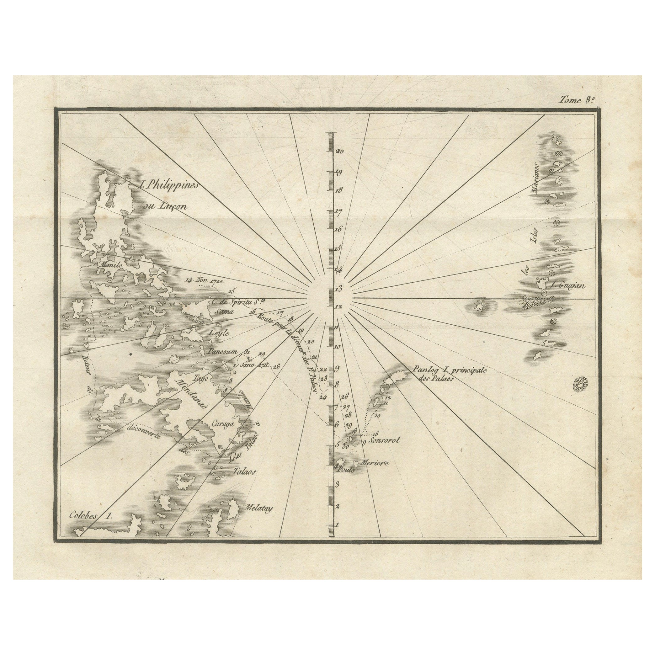
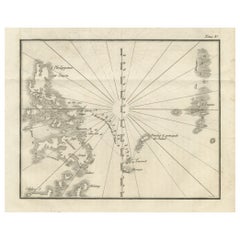
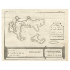
Map of the Philippines and Palau Islands – Antique French Engraving, c.1790
Located in Langweer, NL
Map of the Philippines and Palau Islands – Antique French Engraving, c.1790
This antique French maritime chart depicts the western Pacific region between the Philippines and the Pal...
Category
Antique Late 18th Century French Maps
Materials
Paper
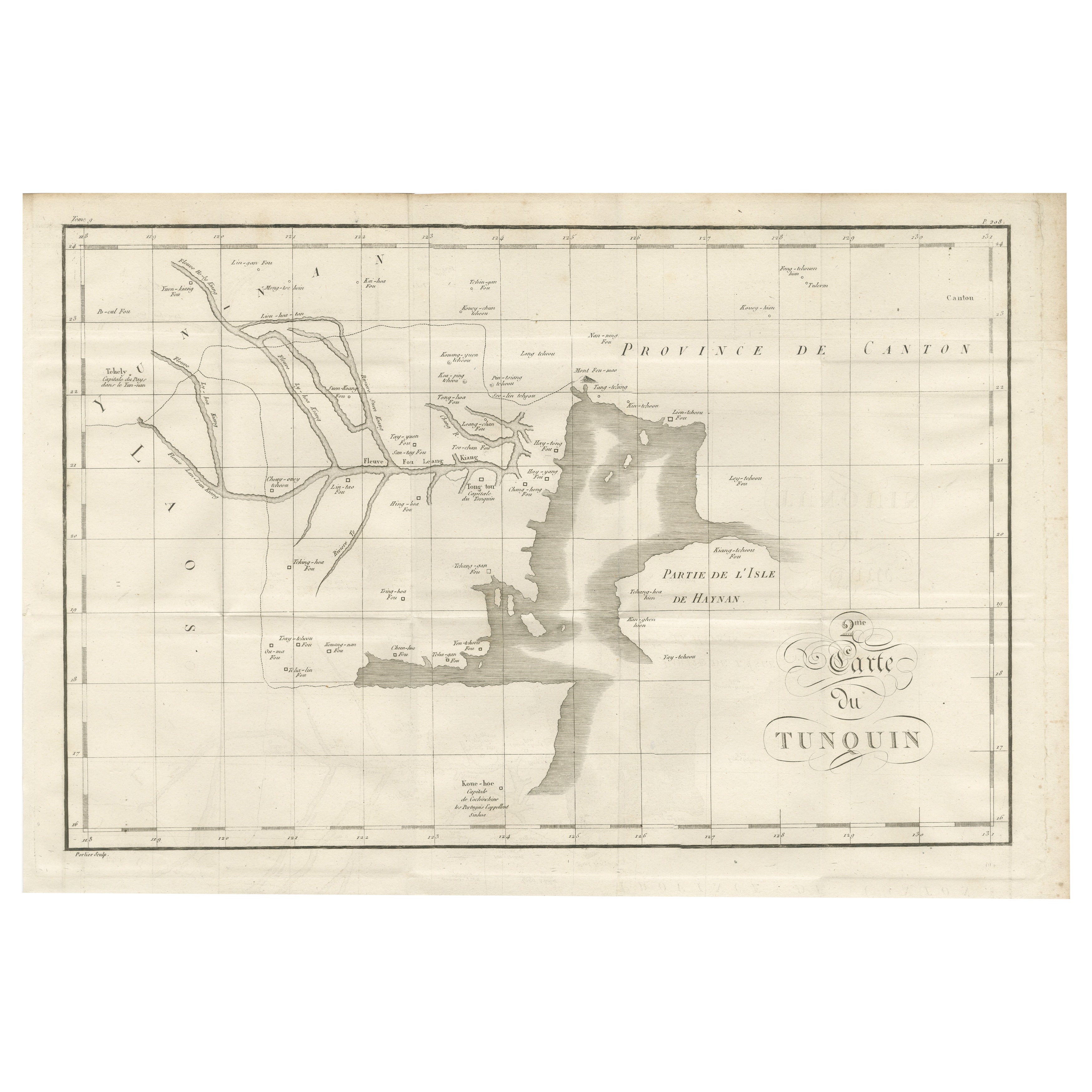
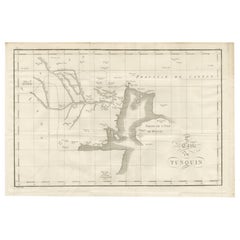
Antique Map of Tonkin and Hainan Island – 18th Century French Engraving
Located in Langweer, NL
Antique Map of Tonkin and Hainan Island – 18th Century French Engraving
This is the “5me Carte du Tunquin,” an antique engraved map depicting the northern coastal region of modern-d...
Category
Antique Late 18th Century French Maps
Materials
Paper
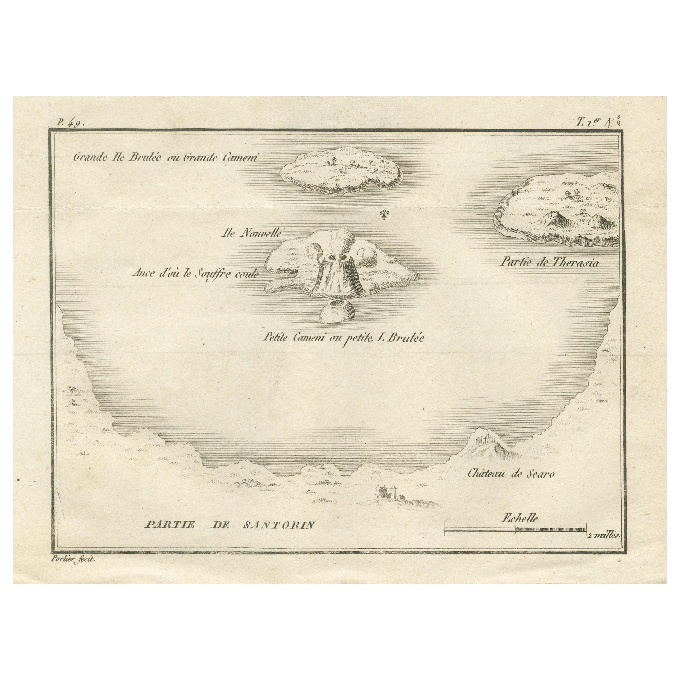
Map of the Volcano Islands of Santorini – Antique Engraving by Portier, ca.1790
Located in Langweer, NL
Map of the Volcano Islands of Santorini – Antique French Engraving by Portier, c.1790
This antique French engraving presents a detailed view of the volcanic islands at the center of...
Category
Antique Late 18th Century French Maps
Materials
Paper
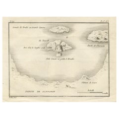
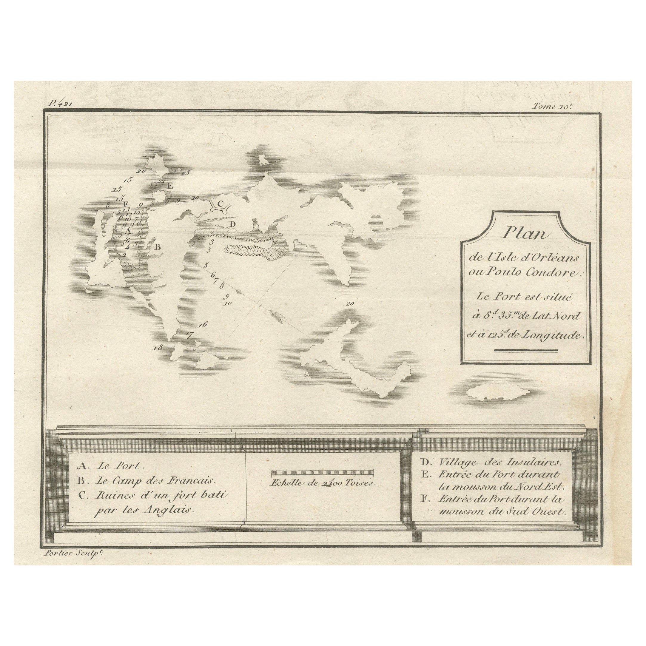
Plan of Poulo Condore (Côn Sơn Island) – Antique French Engraving, ca.1790
Located in Langweer, NL
Plan of Poulo Condore (Côn Sơn Island) – Antique French Engraving by Portier, c.1790
This antique French engraving, created by Portier around 1790, presents a detailed plan of Poulo...
Category
Antique Late 18th Century French Maps
Materials
Paper
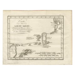
Antique Map of the Ryukyu Islands – Map of the Islands of Lieou-Kieou, c.1760
Located in Langweer, NL
Map of the Ryukyu Islands – “Carte des Isles de Lieou-Kieou”, c.1760
This rare 18th-century copperplate map, titled Carte des Isles de Lieou-Kieou, presents the Ryukyu Islands (toda...
Category
Antique Late 18th Century French Maps
Materials
Paper
You May Also Like
Antique Map - Mare Pacificum - Etching by Johannes Janssonius - 1650s
By Johannes Janssonius
Located in Roma, IT
Mare Pacificum is an antique map realized in 1650 by Johannes Janssonius (1588-1664).
The Map is Hand-colored etching, with coeval watercolorang.
Good conditions with slight foxing...
Category
1650s Modern Figurative Prints
Materials
Etching

West Coast of Africa; Guinea & Sierra Leone: Bellin 18th Century Map
Located in Alamo, CA
This is a Jacques Bellin copper-plate map entitled "Partie de la Coste de Guinee Dupuis la Riviere de Sierra Leona Jusquau Cap das Palmas", depicting the coast of Guinea and Sierra L...
Category
1740s Old Masters Landscape Prints
Materials
Engraving

Antique Map - Mar Di Athiopia - Etching by Johannes Janssonius - 1650s
By Johannes Janssonius
Located in Roma, IT
Antique Map - Mar Di Athiopia is an antique map realized in 1650 by Johannes Janssonius (1588-1664).
The Map is Hand-colored etching, with coeval watercolorang.
Good conditions wit...
Category
1650s Modern Figurative Prints
Materials
Etching

Ancient Map - Zeilan - Etching by Johannes Janssonius - 1650s
By Johannes Janssonius
Located in Roma, IT
Ancient Map - Zeilan is an ancient map realized in 1650 by Johannes Janssonius (1588-1664).
The Map is Hand-colored etching, with coeval watercoloring.
...
Category
1650s Modern Figurative Prints
Materials
Etching

Ancient Map of Senegal - Original Etching - 19th Century
Located in Roma, IT
Map of Senegal is an original etching realized by an anonymous engraver of the 19th Century.
Printed in series of "France Pittoresque" at the top center.
The state of preservation ...
Category
19th Century Figurative Prints
Materials
Etching

Map of Mar Del Nort - Etching by Johannes Janssonius - 1650s
By Johannes Janssonius
Located in Roma, IT
Antique Map -Mar Del Nort is an antique map realized in 1650 by Johannes Janssonius (1588-1664).
The Map is Hand-colored etching, with coeval watercolorang.
Good conditions with sl...
Category
1650s Modern Figurative Prints
Materials
Etching
