Items Similar to Map of Tierra del Fuego and the Straits of Magellan and Le Maire, c.1760


Want more images or videos?
Request additional images or videos from the seller
1 of 10
Map of Tierra del Fuego and the Straits of Magellan and Le Maire, c.1760
$405.19
£300.07
€340
CA$558.24
A$620.66
CHF 326.82
MX$7,530.49
NOK 4,137.65
SEK 3,867.69
DKK 2,588.02
About the Item
Map of Tierra del Fuego and the Straits of Magellan and Le Maire, c.1760
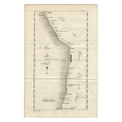
This 18th-century copperplate map, titled Carte de la Terre de Feu et des Détroits de Magellan et de le Maire avec les Nouvelles Isles d’Anycao et de Beauchêne, depicts the southernmost extremity of South America. It includes Tierra del Fuego (*Terre de Feu*), the Strait of Magellan, the Strait of Le Maire, and surrounding islands.
The western part of the map shows the entrance to the Strait of Magellan from the Pacific (Mer du Sud), with points and capes such as C. Victoire, C. Froward, and C. Galland labeled. The eastern section presents the open Atlantic (Mer du Nord) with islands including the Isles d’Anycao, Isles de Beauchêne, Isle de Sable, Isle de l’État, and Isle Barnevelt. The southern limit features Cape Horn (Cap de Horn) and the Diego Ramirez Islands.
Coastal features are carefully delineated, reflecting European navigational interest in this strategic maritime passage linking the Atlantic and Pacific Oceans before the construction of the Panama Canal. By the mid-18th century, the Straits of Magellan were a key route for European exploration and trade with the Pacific, though the treacherous conditions led some navigators to prefer the open sea route around Cape Horn.
The decorative title cartouche occupies the right side of the map, while the lower left contains a scale of 40 leagues. Marked “Tome 5, N° 3” in the upper right, the plate comes from an Enlightenment-era geographic and exploration series documenting significant maritime routes.
Condition: Very good for age, with a central fold as issued. Slight toning and minor creasing in margins. Strong plate impression with sharp coastal detail.
Framing tips: A black or dark walnut frame with an ivory or cream mount will emphasize the fine engraved lines. This map pairs well with other 18th-century maritime charts of South America or Antarctic-adjacent regions.
Technique: Copperplate engraving
Maker: French school, c.1760
- Dimensions:Height: 7.88 in (20 cm)Width: 12.41 in (31.5 cm)Depth: 0.01 in (0.2 mm)
- Materials and Techniques:Paper,Engraved
- Place of Origin:
- Period:
- Date of Manufacture:circa 1760
- Condition:Condition: Very good for age, with a central fold as issued. Slight toning and minor creasing in margins. Strong plate impression with sharp coastal detail.
- Seller Location:Langweer, NL
- Reference Number:Seller: BG-14078-361stDibs: LU3054346218692
About the Seller
5.0
Recognized Seller
These prestigious sellers are industry leaders and represent the highest echelon for item quality and design.
Platinum Seller
Premium sellers with a 4.7+ rating and 24-hour response times
Established in 2009
1stDibs seller since 2017
2,569 sales on 1stDibs
Typical response time: <1 hour
- ShippingRetrieving quote...Shipping from: Langweer, Netherlands
- Return Policy
Authenticity Guarantee
In the unlikely event there’s an issue with an item’s authenticity, contact us within 1 year for a full refund. DetailsMoney-Back Guarantee
If your item is not as described, is damaged in transit, or does not arrive, contact us within 7 days for a full refund. Details24-Hour Cancellation
You have a 24-hour grace period in which to reconsider your purchase, with no questions asked.Vetted Professional Sellers
Our world-class sellers must adhere to strict standards for service and quality, maintaining the integrity of our listings.Price-Match Guarantee
If you find that a seller listed the same item for a lower price elsewhere, we’ll match it.Trusted Global Delivery
Our best-in-class carrier network provides specialized shipping options worldwide, including custom delivery.More From This Seller
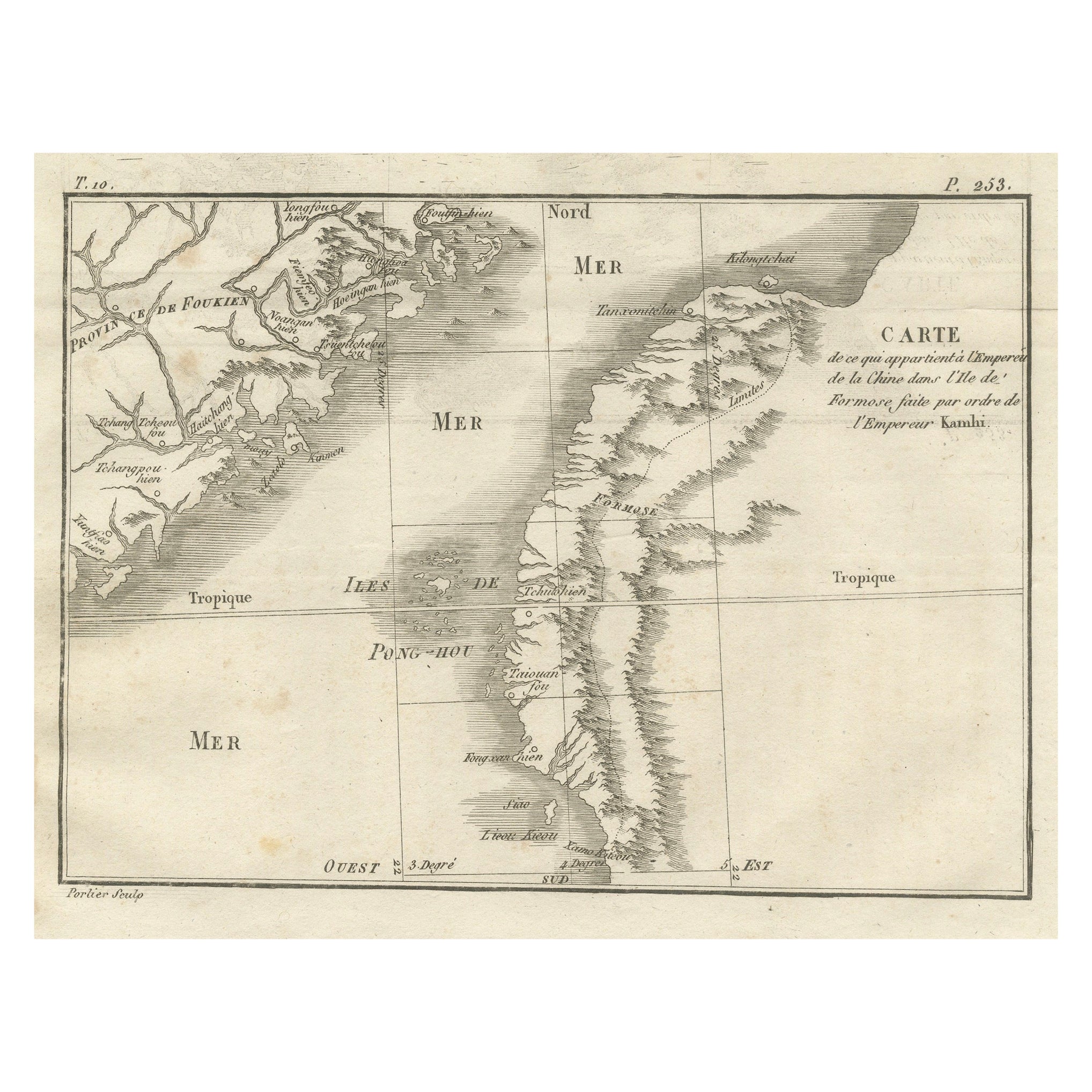
View AllMap of Formosa and Pescadores – French Jesuit Engraving by Portier, c.1790
Located in Langweer, NL
Map of Formosa and Pescadores – French Jesuit Engraving by Portier, c.1790
This antique French map, engraved by Portier around 1790, depicts the island of Formosa (modern Taiwan), t...
Category
Antique Late 18th Century French Maps
Materials
Paper
Martinique Map by Rigobert Bonne – French Antique Map, c.1768
Located in Langweer, NL
Map of Martinique by Rigobert Bonne, circa 1768
This is a detailed antique map of Martinique titled “Isle de la Martinique,” engraved by Rigobert Bonne around 1768 for the Atlas Encyclopédique. Bonne, a renowned French hydrographer and successor to Bellin, is celebrated for his scientifically precise and elegantly engraved maps.
The map shows Martinique with its mountainous interior, rivers, and settlements labelled, including Fort Royal, Fort St. Pierre, Le Marin, and Le Prêcheur. Coastal features, bays, and capes are marked, along with anchorages important for maritime navigation in the 18th century. The depiction includes relief shown pictorially, characteristic of Bonne’s cartographic style, enhancing both geographic understanding and aesthetic appeal.
This copperplate engraving retains original hand colouring outlining the coastlines in delicate blue and brown tones, typical for the period. It served as a key reference for scholars, navigators, and colonial administrators during France’s colonial presence in the Caribbean.
Condition:
Good condition overall. A strong impression with bright, original hand-colour outlines. General age toning, faint offsetting, and a vertical fold as issued in the atlas. Margins ample all around for framing.
Framing suggestions:
This historic Caribbean map...
Category
Antique 1760s French Maps
Materials
Paper

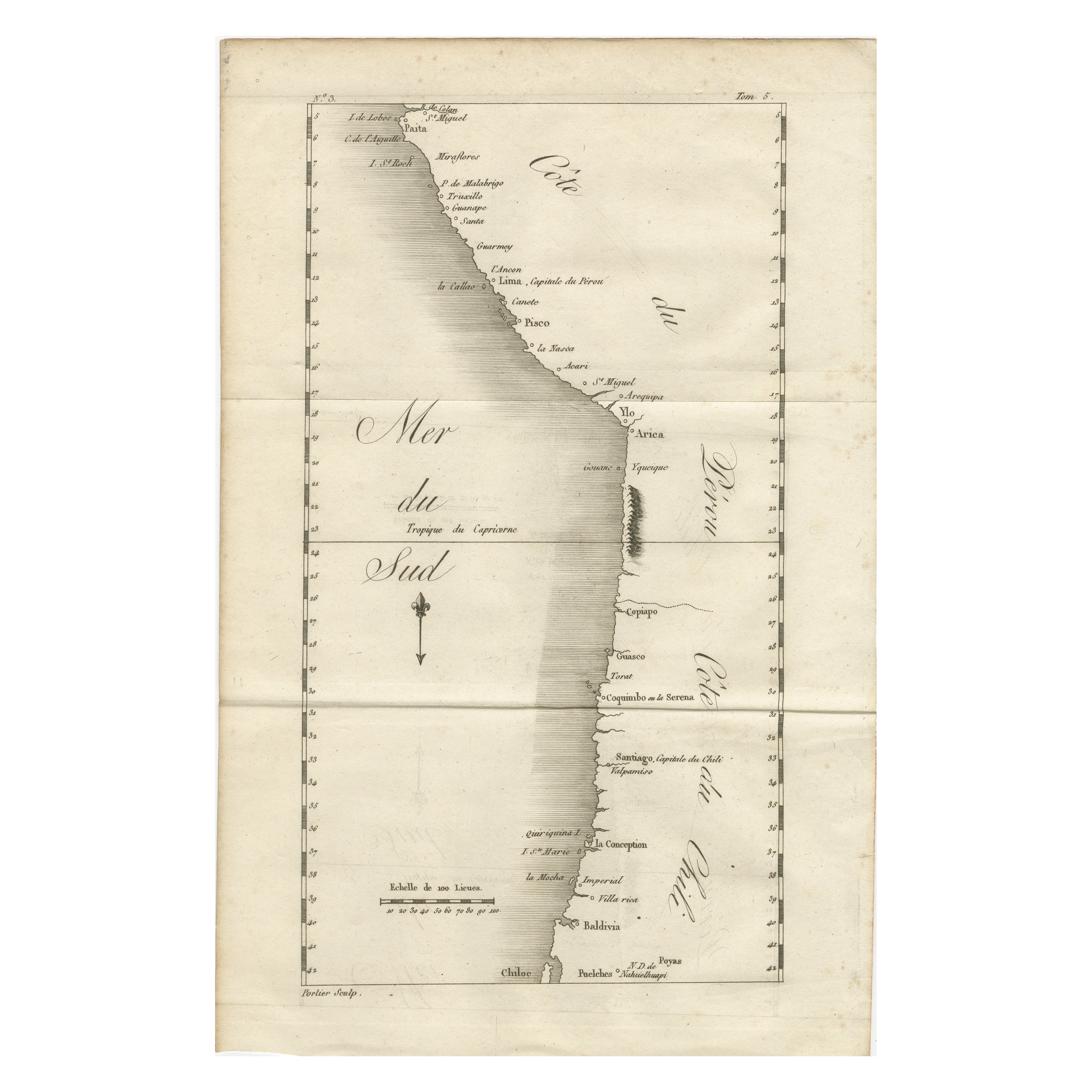
Antique Map of the Coast of Peru and Chile – Detailing Ports & Coastlines, c1760
Located in Langweer, NL
Map of the Coast of Peru and Chile – “Côte du Pérou et Côte du Chili”, c.1760
This 18th-century copperplate engraving presents a detailed chart of the Pacific coastline from norther...
Category
Antique Late 18th Century French Maps
Materials
Paper
Antique Map of the Environs of Cap-Français, Saint-Domingue, c.1760
Located in Langweer, NL
Antique Map of the Environs of Cap-Français, Saint-Domingue, c.1760
This detailed 18th-century copperplate engraving, titled Carte des Environs du Cap Français et des Paroisses qui ...
Category
Antique Early 18th Century French Maps
Materials
Paper
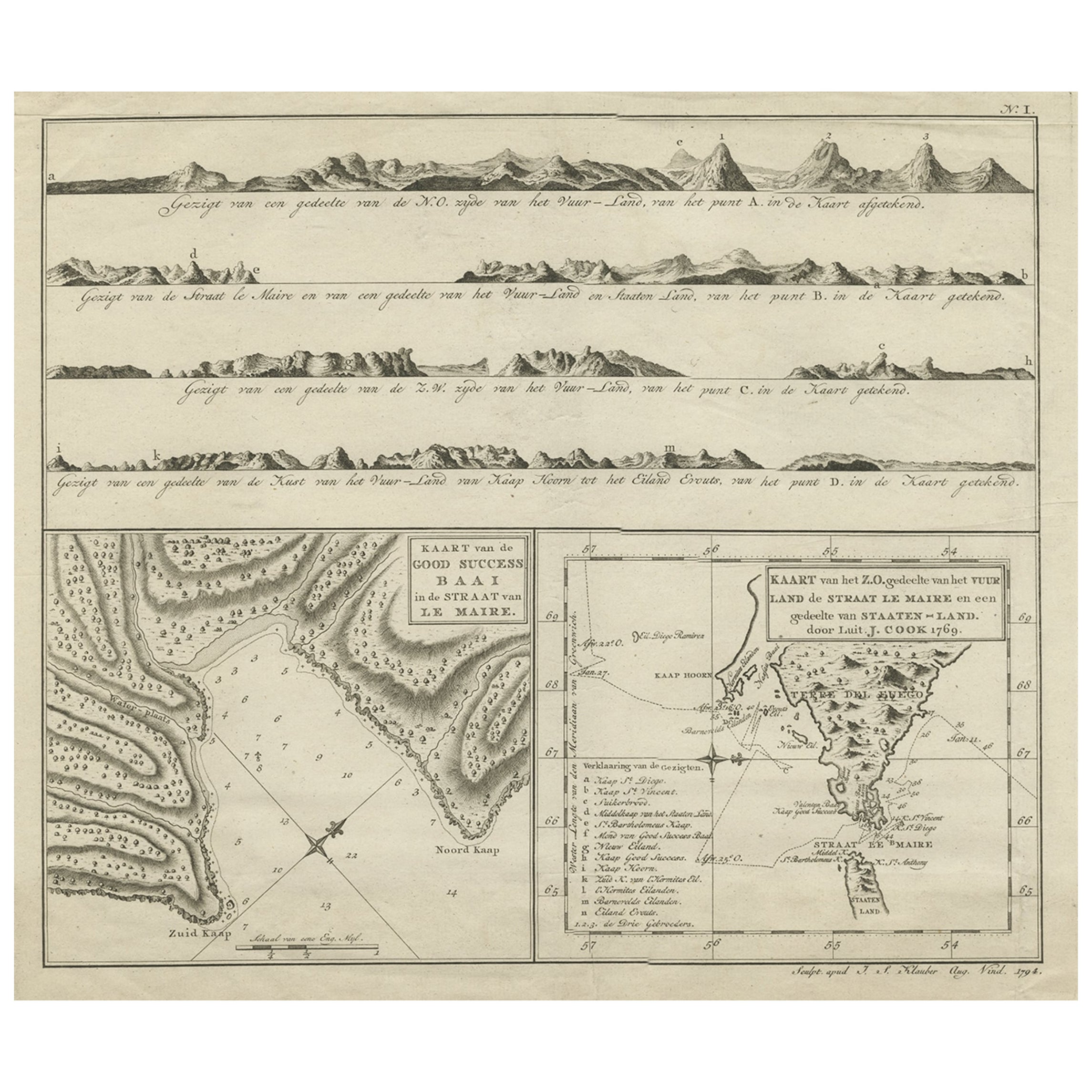
Antique Map of the Strait of Le Maire Between Terra Fuego & Staten Island, 1803
Located in Langweer, NL
Antique map titled 'Kaart van de Good Success Baai in de Straat van Le Maire (..)'.
Antique map of the Strait of Le Maire between Terra Fuego and Staten Island. On top, various c...
Category
Antique Early 1800s Maps
Materials
Paper
$600 Sale Price
20% Off
Antique Map of South America by J. Cook (1775)
Located in Langweer, NL
Antique map titled 'Kaart van het Zuidlyk Eind van Amerika'. Map of the sourthern part of South America, focusing on Cook's tracks around the Cape Horn and Tierra del Fuego in 1775. ...
Category
Antique Late 18th Century Maps
Materials
Paper

$562 Sale Price
20% Off
You May Also Like
Antique 1765 Wine Country Folding Map of France, Bordeau etc.
Located in Paonia, CO
Route du Carosse de Bordeaux, part de Paris tous les Mardis a 11 matin. a et pafse 1765 is a comprehensive map with two routes through the wine country of France starting in Paris going south...
Category
1760s Other Art Style Landscape Prints
Materials
Etching

California: 18th Century Hand-colored Map by de Vaugondy
By Didier Robert de Vaugondy
Located in Alamo, CA
This is an 18th century hand-colored map of the western portions of North America entitled "Carte de la Californie et des Pays Nord-Ouest separés de l'Asie par le détroit d'Anian, ex...
Category
1770s Landscape Prints
Materials
Engraving

Original Antique Map of South America. C.1780
Located in St Annes, Lancashire
Great map of South America
Copper-plate engraving
Published C.1780
Two small worm holes to left side of map
Unframed.
Category
Antique Early 1800s English Georgian Maps
Materials
Paper

Southerlandia Map - Etching by Johannes Janssonius - 1650
By Johannes Janssonius
Located in Roma, IT
Southerlandia Map is an ancient map realized in 1650 by Johannes Janssonius (1588-1664).
The Map is Hand-colored etching, with coeval watercoloring.
Good conditions.
From Atlantis...
Category
1650s Modern Figurative Prints
Materials
Etching

West Coast of Africa; Guinea & Sierra Leone: Bellin 18th Century Map
Located in Alamo, CA
This is a Jacques Bellin copper-plate map entitled "Partie de la Coste de Guinee Dupuis la Riviere de Sierra Leona Jusquau Cap das Palmas", depicting the coast of Guinea and Sierra L...
Category
1740s Old Masters Landscape Prints
Materials
Engraving

Map of Mar Del Nort - Etching by Johannes Janssonius - 1650s
By Johannes Janssonius
Located in Roma, IT
Antique Map -Mar Del Nort is an antique map realized in 1650 by Johannes Janssonius (1588-1664).
The Map is Hand-colored etching, with coeval watercolorang.
Good conditions with sl...
Category
1650s Modern Figurative Prints
Materials
Etching
