Items Similar to Nebraska Railroad Map 1888 – Rand McNally Antique Lithograph
Want more images or videos?
Request additional images or videos from the seller
1 of 10
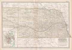
Nebraska Railroad Map 1888 – Rand McNally Antique Lithograph
$573.91
£424.39
€480
CA$794.20
A$884.30
CHF 460.17
MX$10,673.30
NOK 5,770.97
SEK 5,451.04
DKK 3,655.23
About the Item
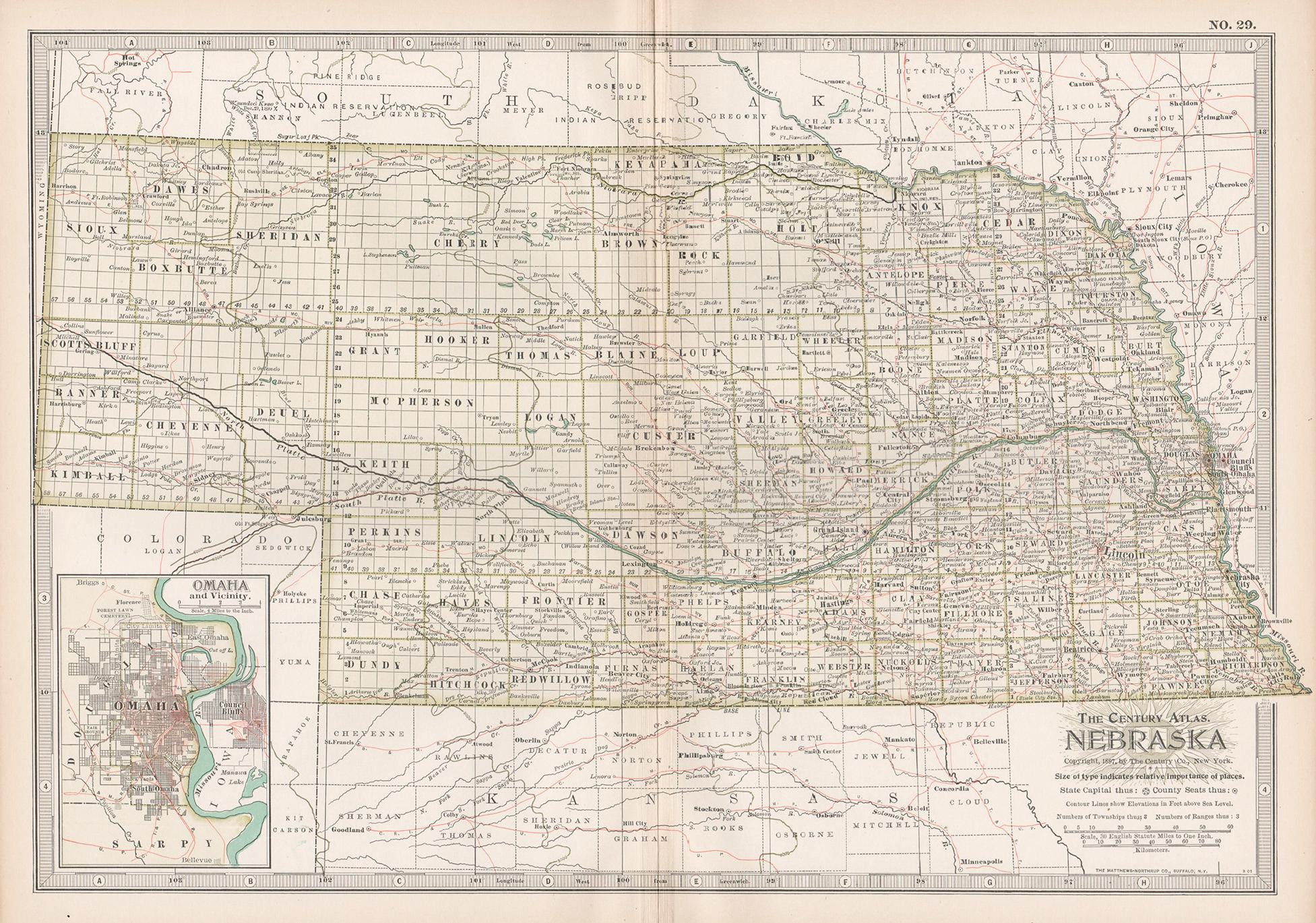
Nebraska Railroad Map 1888 – Rand McNally Antique Lithograph
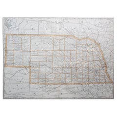
This finely detailed map of Nebraska, published by Rand, McNally & Co. in 1888, provides an excellent overview of the state at a pivotal moment in its development. Produced during the great railroad expansion era, the map illustrates the rapidly growing network of rail lines crisscrossing the plains, helping to transform Nebraska from a frontier region into a thriving agricultural and transport hub.
The map clearly shows counties, towns, settlements, railroads, rivers, and geographical features across the state. Major cities such as Omaha, Lincoln, and Grand Island are emphasized, while countless smaller towns and railway stations reflect the rapid pace of settlement. County divisions are neatly engraved, and the map captures both well-established areas in the east and the more sparsely settled western counties, such as Sioux, Sheridan, Cherry, and Dawes.
Railroads dominate the landscape, with extensive red and blue lines marking the routes of the Union Pacific, Chicago, Burlington & Quincy, Chicago, Rock Island & Pacific, and other key lines. These routes highlight Nebraska’s central role in linking the Midwest with the western territories and the Pacific Coast. The Union Pacific’s line running through North Platte and Kearney is particularly notable, as it formed a vital segment of the first transcontinental railroad.
Equally striking are the references to Native American lands and agencies in northern Nebraska, including the Omaha and Winnebago Reservations, as well as connections across the Missouri River into Iowa and South Dakota. The presence of military forts, such as Old Fort Kearny and Fort Sidney just over the Colorado border, underlines the state’s importance as a transportation corridor during the late 19th century.
The map’s precision reflects Rand, McNally & Co.’s growing reputation as one of America’s leading map publishers. Its combination of railroad detail, county divisions, and settlement names makes it an invaluable resource for historians, genealogists, and collectors with an interest in the development of the Great Plains. For those tracing family roots or studying the history of Nebraska’s transformation from frontier to statehood (achieved in 1867), this 1888 edition offers an authentic period perspective.
Condition: Good, with age toning, light foxing, and small edge wear consistent with age. Plate mark visible. Paper remains strong with no major tears or losses.
Framing tips: A walnut or cherry wood frame with a cream or pale beige mat will highlight the map’s antique charm. A double mat with a subtle red or blue under-mat can emphasize the railroad lines.
Technique: Lithograph with printed color
Maker: Rand, McNally & Co., Chicago, 1888
- Dimensions:Height: 14.18 in (36 cm)Width: 20.67 in (52.5 cm)Depth: 0.01 in (0.2 mm)
- Materials and Techniques:Paper,Engraved
- Place of Origin:
- Period:
- Date of Manufacture:1888
- Condition:Condition: Good, with age toning, light foxing, and small edge wear consistent with age. Plate mark visible. Paper remains strong with no major tears or losses.
- Seller Location:Langweer, NL
- Reference Number:Seller: BG-12794-521stDibs: LU3054346382872
About the Seller
5.0
Recognized Seller
These prestigious sellers are industry leaders and represent the highest echelon for item quality and design.
Platinum Seller
Premium sellers with a 4.7+ rating and 24-hour response times
Established in 2009
1stDibs seller since 2017
2,587 sales on 1stDibs
Typical response time: <1 hour
- ShippingRetrieving quote...Shipping from: Langweer, Netherlands
- Return Policy
Authenticity Guarantee
In the unlikely event there’s an issue with an item’s authenticity, contact us within 1 year for a full refund. DetailsMoney-Back Guarantee
If your item is not as described, is damaged in transit, or does not arrive, contact us within 7 days for a full refund. Details24-Hour Cancellation
You have a 24-hour grace period in which to reconsider your purchase, with no questions asked.Vetted Professional Sellers
Our world-class sellers must adhere to strict standards for service and quality, maintaining the integrity of our listings.Price-Match Guarantee
If you find that a seller listed the same item for a lower price elsewhere, we’ll match it.Trusted Global Delivery
Our best-in-class carrier network provides specialized shipping options worldwide, including custom delivery.More From This Seller
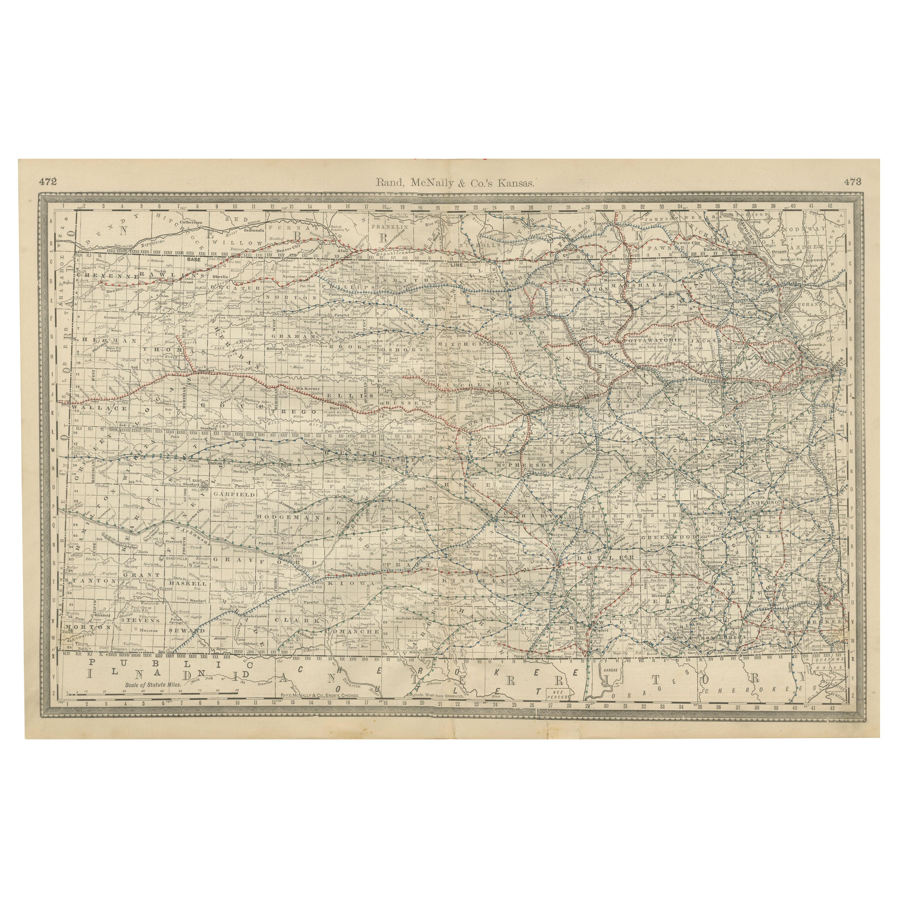
View AllKansas Railroad Map 1888 – Rand McNally Antique Lithograph
Located in Langweer, NL
Kansas Railroad Map 1888 – Rand McNally Antique Lithograph
This antique 1888 map of Kansas by Rand, McNally & Co. offers a detailed view of the state during a period of rapid expans...
Category
Antique Late 19th Century American Maps
Materials
Paper
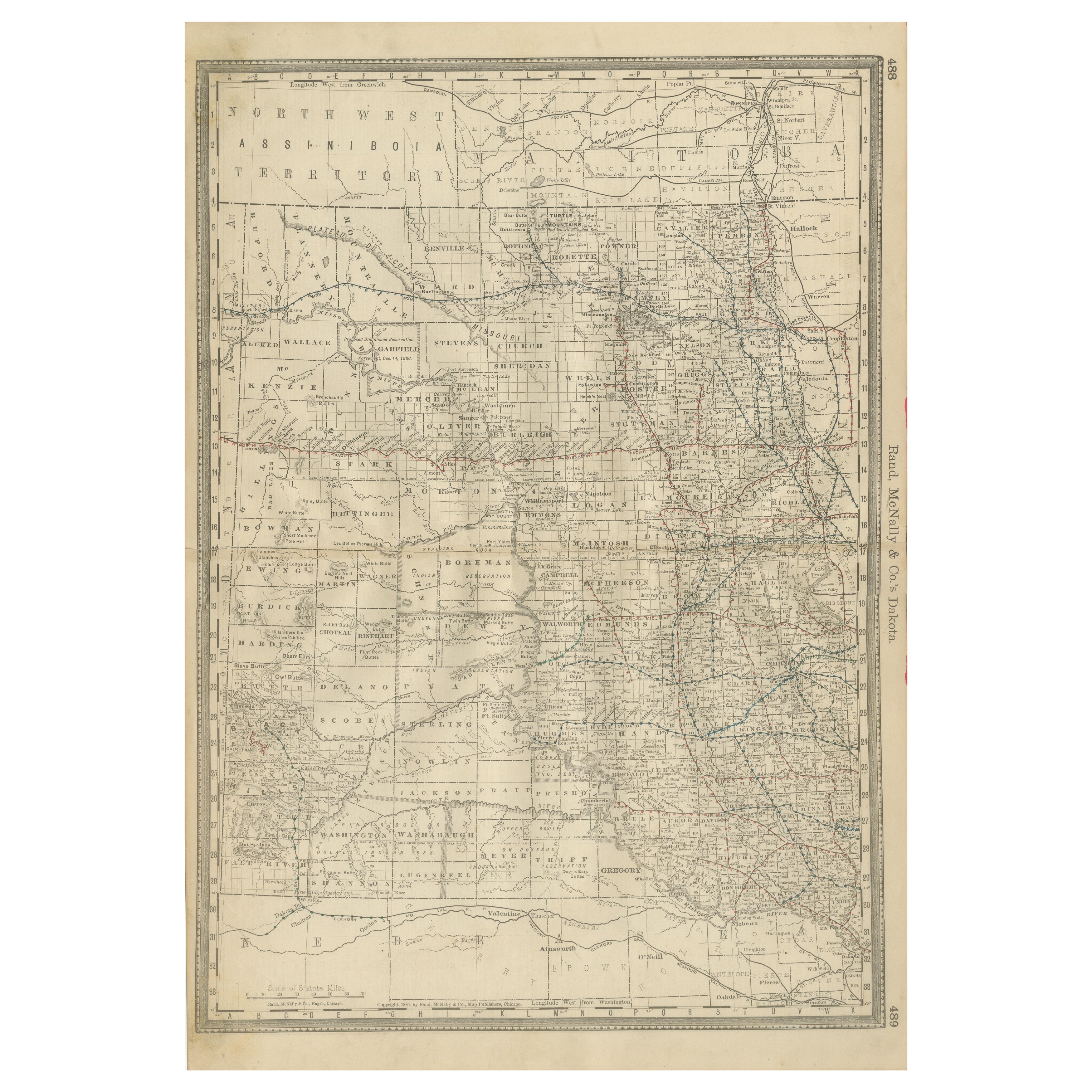
Dakota Territory Railroad Map 1888 – Rand McNally Antique Lithograph
Located in Langweer, NL
Antique Map of Dakota Territory – Rand McNally Railroad Map, 1888
This detailed 1888 map of Dakota by Rand, McNally & Co. captures the region in the final year before its division i...
Category
Antique Late 19th Century American Maps
Materials
Paper
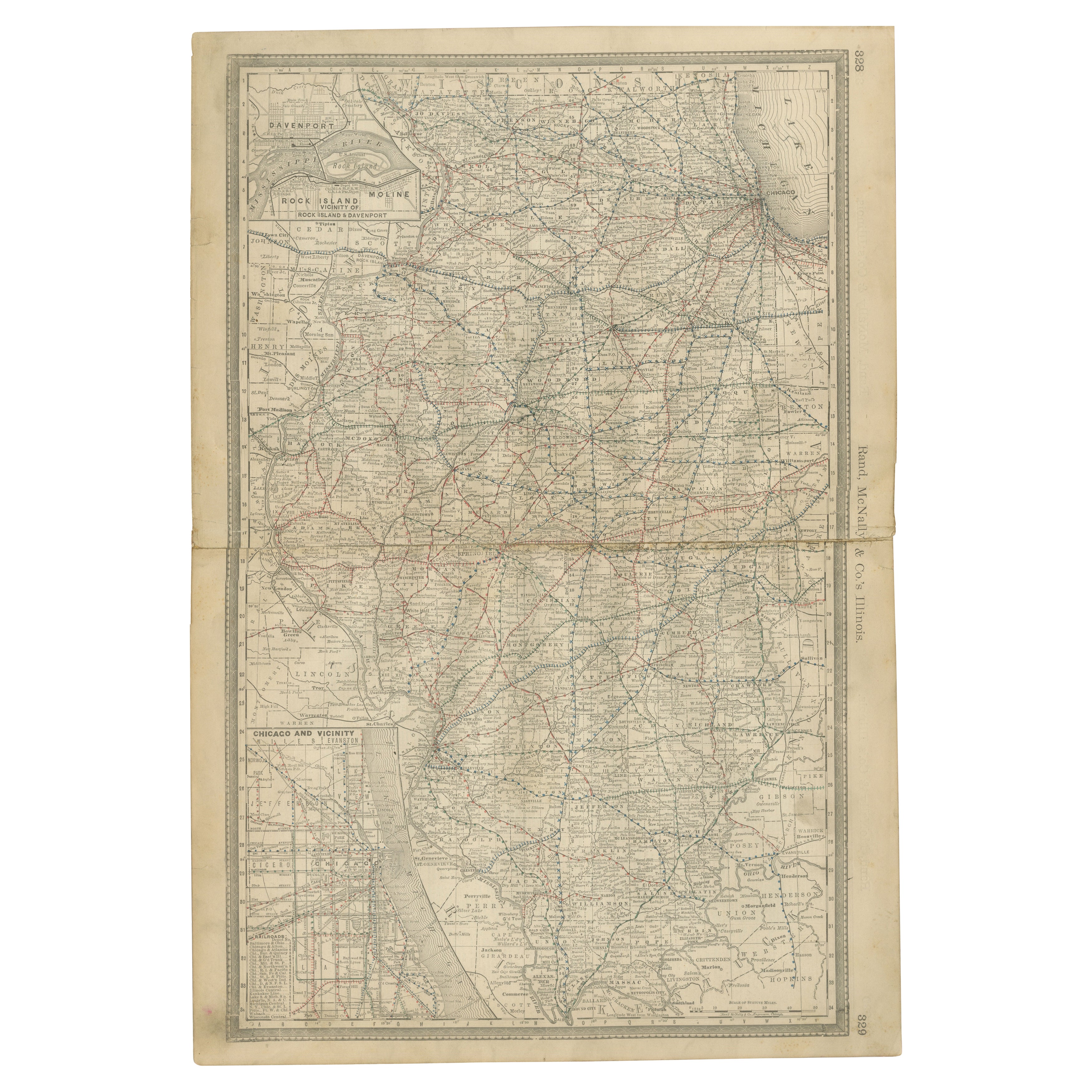
Detailed Antique Map of Illinois – Railroads, Cities & Counties, 1888
Located in Langweer, NL
Antique Map of Illinois – Railroads, Cities & Counties, 1888
This finely detailed antique map shows the state of Illinois in the late 19th century, engraved and published in 1888 by...
Category
Antique Late 19th Century American Maps
Materials
Paper

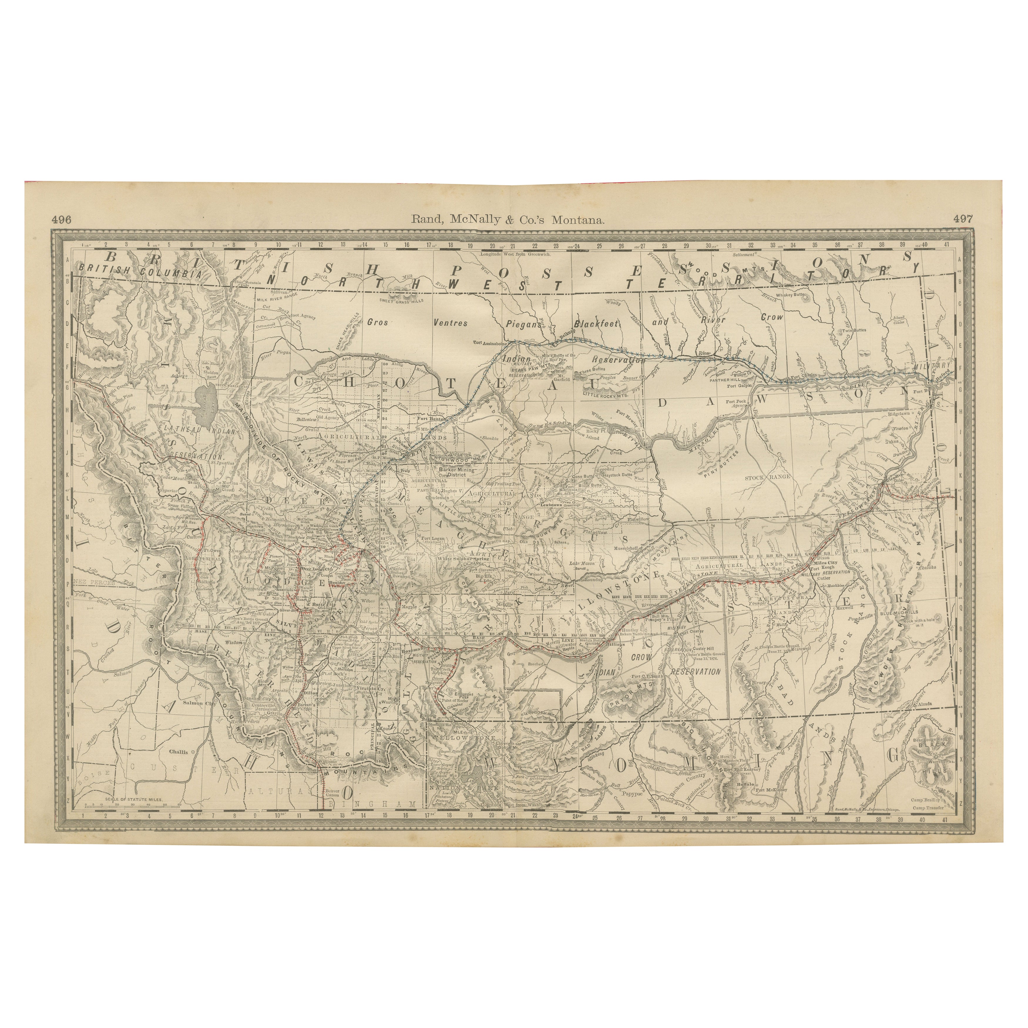
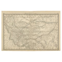
Old Map of Montana – Railroads, Indian Reservations & Frontier Settlements 1888
Located in Langweer, NL
Antique Map of Montana – Railroads, Indian Reservations & Frontier Settlements, 1888
This antique engraved map depicts the Territory of Montana in 1888, engraved and published by Ra...
Category
Antique Late 19th Century American Maps
Materials
Paper
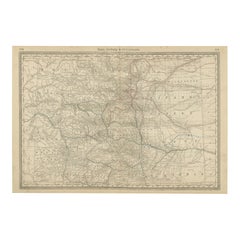
1888 Colorado Map – The Centennial State’s Railroads, Mines & Counties
Located in Langweer, NL
Antique Map of Colorado – Railroads, Mining Towns & Counties, 1888
This antique engraved map depicts the state of Colorado in 1888, published by Rand, McNally & Co. in Chicago for t...
Category
Antique Late 19th Century American Maps
Materials
Paper
1888 New Mexico Map – Railroads, Counties & The Land of Enchantment
Located in Langweer, NL
Antique Map of New Mexico – Railroads, Counties & Frontier Settlements, 1888
This antique engraved map depicts the Territory of New Mexico in 1888, engraved and published by Rand, M...
Category
Antique Late 19th Century American Maps
Materials
Paper

You May Also Like
Nebraska. USA. Century Atlas state antique vintage map
Located in Melbourne, Victoria
'The Century Atlas. Nebraska.'
Original antique map, 1903.
Central fold as issued. Map name and number printed on the reverse corners.
Sheet 29.5cm by 40cm.
Category
Early 20th Century Victorian More Prints
Materials
Lithograph
Large Original Antique Map of Nebraska, USA, 1894
By Rand McNally & Co.
Located in St Annes, Lancashire
Fabulous map of Nebraska
Original color
By Rand, McNally & Co.
Published, 1894
Unframed
Some slight restoration to the Gosper / Furnas area. Seen in the last image
Free shipping.
Category
Antique 1890s American Maps
Materials
Paper
Original Antique Map of the American State of Nebraska, 1903
Located in St Annes, Lancashire
Antique map of Nebraska
Published By A & C Black. 1903
Original colour
Good condition
Unframed.
Free shipping
Category
Antique Early 1900s English Maps
Materials
Paper

South Dakota. USA. Century Atlas state antique vintage map
Located in Melbourne, Victoria
'The Century Atlas. South Dakota.'
Original antique map, 1903.
Central fold as issued. Map name and number printed on the reverse corners.
Sheet 29.5cm ...
Category
Early 20th Century Victorian More Prints
Materials
Lithograph
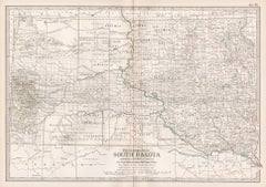
Original Antique Map of South Dakota by Rand McNally, circa 1900
By Rand McNally & Co.
Located in St Annes, Lancashire
Fabulous monochrome map with red outline color
Original color
By Rand, McNally & Co.
Published, circa 1900
Unframed
Minor edge tears.
Category
Antique Early 1900s American Edwardian Maps
Materials
Paper

Original Antique Map of the American State of South Dakota, 1903
Located in St Annes, Lancashire
Antique map of South Dakota
Published By A & C Black. 1903
Original colour
Good condition
Unframed.
Free shipping
Category
Antique Early 1900s English Maps
Materials
Paper
