Items Similar to Old Map of Carnarvonshire 1844 – Caernarfon Bangor Pwllheli Beaumaris Bay
Want more images or videos?
Request additional images or videos from the seller
1 of 10
Old Map of Carnarvonshire 1844 – Caernarfon Bangor Pwllheli Beaumaris Bay
$228.35
$285.4320% Off
£169.91
£212.3920% Off
€192
€24020% Off
CA$313.74
CA$392.1720% Off
A$350.16
A$437.7020% Off
CHF 184.22
CHF 230.2820% Off
MX$4,253.45
MX$5,316.8120% Off
NOK 2,335.46
NOK 2,919.3220% Off
SEK 2,185.69
SEK 2,732.1220% Off
DKK 1,461.62
DKK 1,827.0320% Off
About the Item
Title: Old Map of Carnarvonshire by Samuel Lewis 1844 – Caernarfon Bangor Pwllheli Beaumaris Bay
Description: This antique map of Carnarvonshire was published in 1844 for Samuel Lewis’ Topographical Dictionary of Wales. It features major towns and landmarks including Caernarfon, Bangor, Pwllheli, and the scenic Beaumaris Bay. The map shows shaded terrain, rivers, and coastal outlines, with hand-colored borders dividing the county’s various unions. A decorative compass rose and a reference key add historical detail and charm.
Condition:
The map is in very good condition with some light age toning and clean margins. The engraved lines are sharp and the original hand coloring remains bright and clear. There are no visible tears or major imperfections.
Framing suggestions:
Use an ivory, cream, or light tan acid-free mat to complement the aged paper and colored borders. Choose a frame in dark wood, black with a soft finish, or antique gold to enhance the historical appeal. UV-protective glass is recommended. A striking piece for a study, hallway, or as a gift for those with North Welsh heritage or an interest in vintage maps.
Keywords:
Carnarvonshire map 1844 Samuel Lewis antique map Wales Caernarfon Bangor Pwllheli Beaumaris Bay historical map Victorian cartography hand-colored Welsh counties Cardigan Bay
- Dimensions:Height: 8.75 in (22.2 cm)Width: 11.23 in (28.5 cm)Depth: 0.01 in (0.2 mm)
- Materials and Techniques:
- Period:
- Date of Manufacture:1844
- Condition:The map is in very good condition with some light age toning and clean margins. The engraved lines are sharp and the original hand coloring remains bright and clear. There are no visible tears or major imperfections.
- Seller Location:Langweer, NL
- Reference Number:Seller: BG-027341stDibs: LU3054344599902
About the Seller
5.0
Recognized Seller
These prestigious sellers are industry leaders and represent the highest echelon for item quality and design.
Platinum Seller
Premium sellers with a 4.7+ rating and 24-hour response times
Established in 2009
1stDibs seller since 2017
2,565 sales on 1stDibs
Typical response time: <1 hour
- ShippingRetrieving quote...Shipping from: Langweer, Netherlands
- Return Policy
Authenticity Guarantee
In the unlikely event there’s an issue with an item’s authenticity, contact us within 1 year for a full refund. DetailsMoney-Back Guarantee
If your item is not as described, is damaged in transit, or does not arrive, contact us within 7 days for a full refund. Details24-Hour Cancellation
You have a 24-hour grace period in which to reconsider your purchase, with no questions asked.Vetted Professional Sellers
Our world-class sellers must adhere to strict standards for service and quality, maintaining the integrity of our listings.Price-Match Guarantee
If you find that a seller listed the same item for a lower price elsewhere, we’ll match it.Trusted Global Delivery
Our best-in-class carrier network provides specialized shipping options worldwide, including custom delivery.More From This Seller
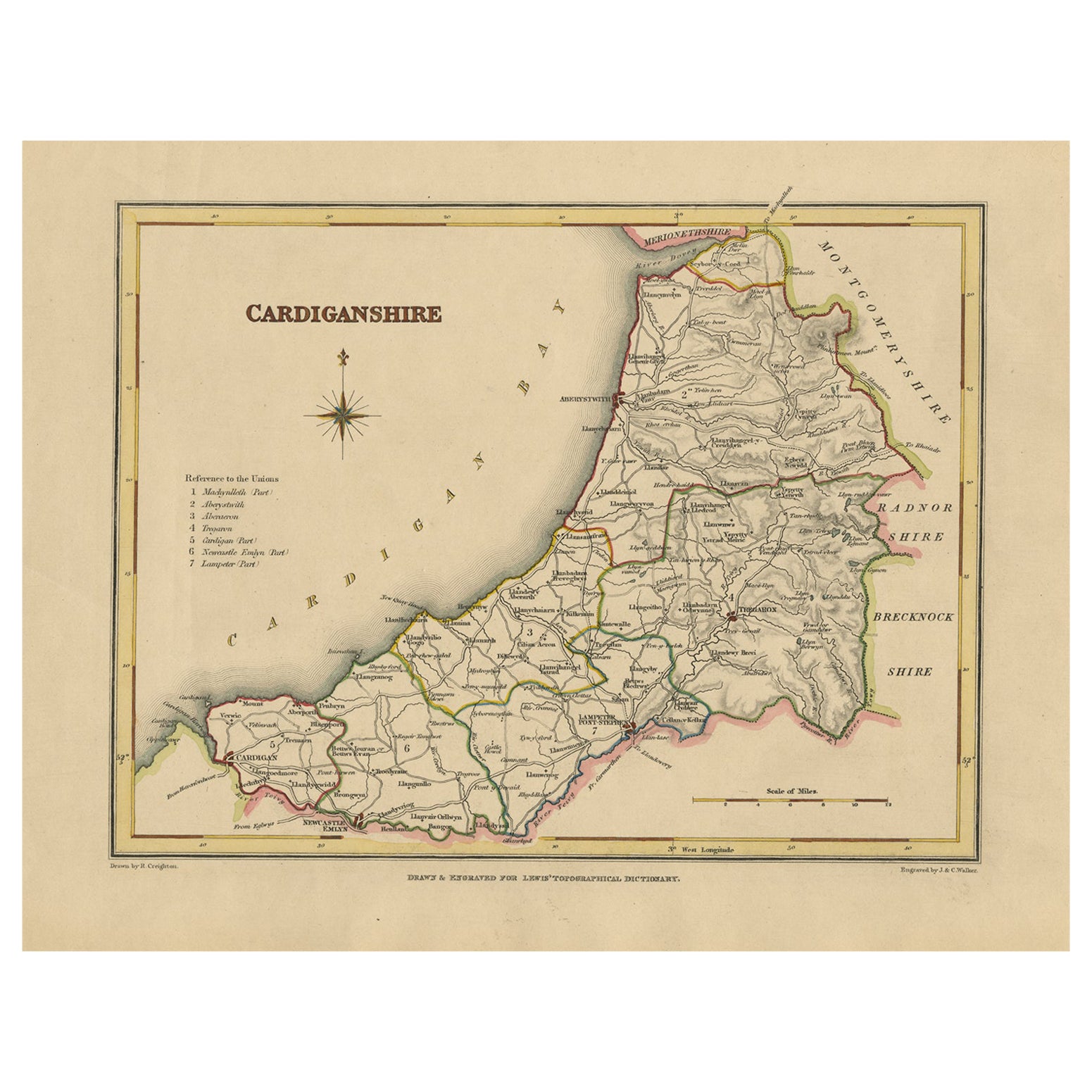
View AllOld Map of Cardiganshire by Lewis 1844 – Aberystwyth Cardigan Tregaron Lampeter
Located in Langweer, NL
Old Map of Cardiganshire by Samuel Lewis 1844 – Aberystwyth Cardigan Tregaron Lampeter
This antique 1844 map of Cardiganshire was drawn and engraved ...
Category
Antique 1840s Maps
Materials
Paper

$228 Sale Price
20% Off
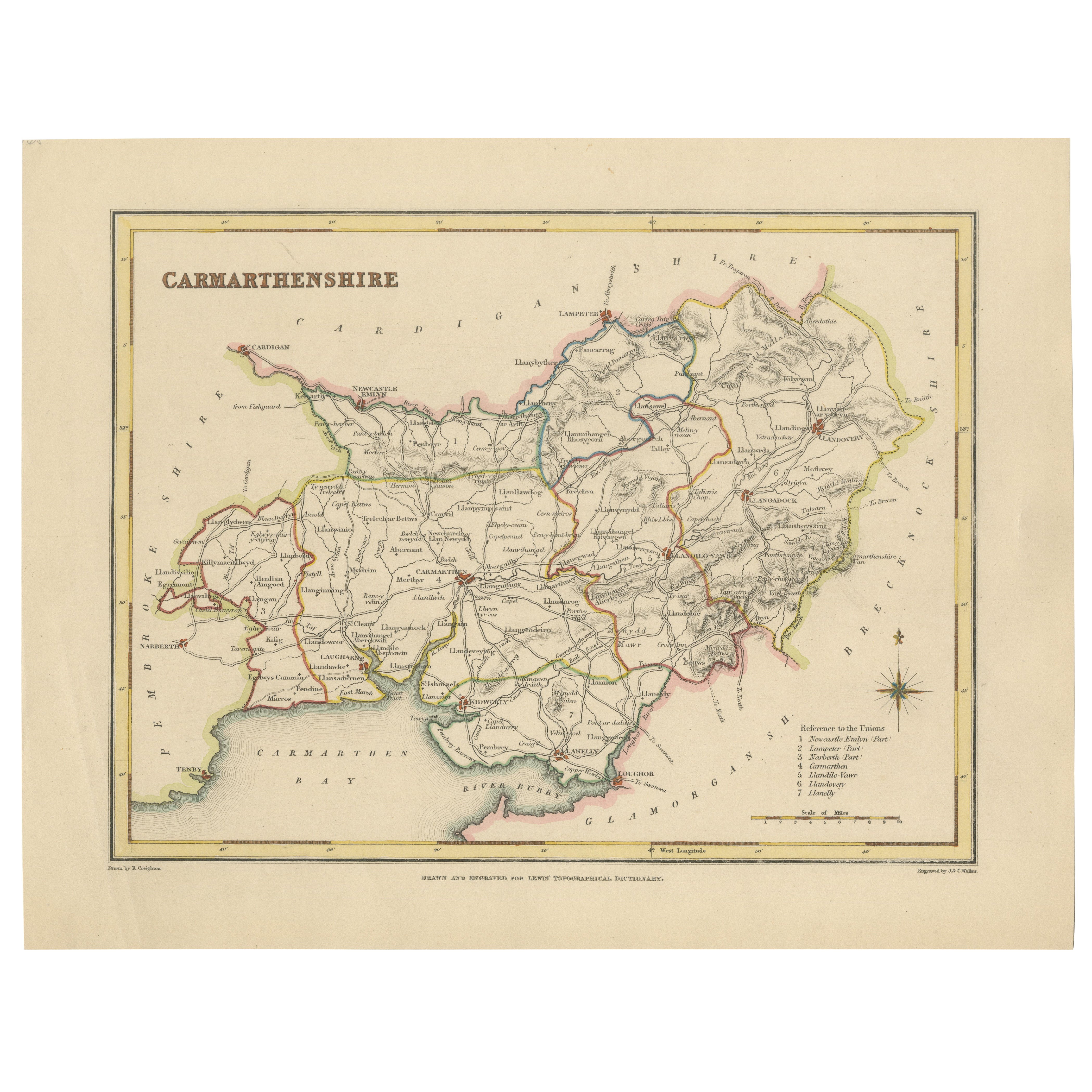
Map of Carmarthenshire 1844 – Carmarthen Llandeilo Llanelli Laugharne Llandovery
Located in Langweer, NL
Title: Old Map of Carmarthenshire by Samuel Lewis 1844 – Carmarthen Llandeilo Llanelli Laugharne Llandovery
Description: This detailed 1844 map of Carmarthenshire was drawn and engraved for Samuel Lewis’ Topographical Dictionary of Wales. It highlights major towns such as Carmarthen, Llandeilo, Llanelli, Laugharne, and Llandovery. The county's roads, rivers, and hilly terrain are finely engraved and shaded, while original hand coloring outlines the administrative divisions. The map includes a compass rose and a reference to the seven unions within the county.
Condition:
The map is in very good antique condition with minimal age toning and wide clean margins. The engraving is crisp and the hand coloring remains bright and accurate. There are no tears or major defects.
Framing suggestions:
A cream or soft beige acid-free mat will complement the aged paper and hand coloring. Frame in dark wood, antique gold, or a muted black to highlight the historical character. Use UV-protective glass to preserve the colors. Suitable for traditional interiors, libraries, or as a heritage gift.
Keywords:
Carmarthenshire map 1844 Samuel Lewis antique...
Category
Antique 1840s Maps
Materials
Paper
$228 Sale Price
20% Off
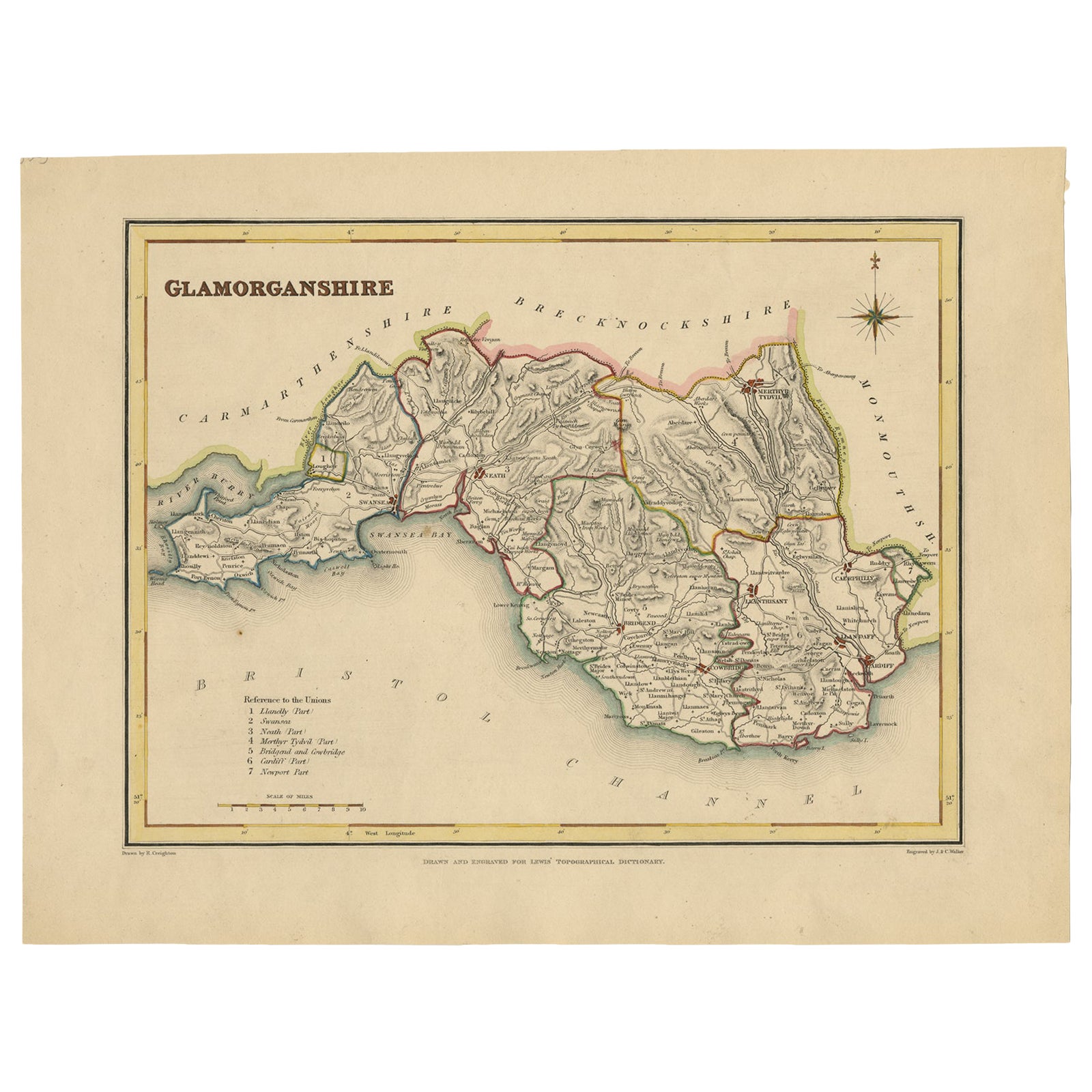
Old Map of Glamorganshire by Lewis 1844 – Swansea Cardiff Merthyr Tydfil Neath
Located in Langweer, NL
Title: Old Map of Glamorganshire by Samuel Lewis 1844 – Swansea Cardiff Merthyr Tydfil Neath
Description: This detailed map of Glamorganshire was published in 1844 for Samuel Lewis’ Topographical Dictionary of Wales. It showcases major towns such as Swansea, Cardiff, Merthyr Tydfil, Neath, and Bridgend. The map features original hand coloring that outlines the county borders and includes shaded topographical elements to show the landscape. A decorative compass rose and a reference to the seven unions add both style and historical context.
Condition:
The map is in good antique condition with minor age toning and clean margins. The engraving remains sharp and the original colors are clear and unfaded. No major damage or repairs are visible.
Framing suggestions:
Use a soft cream or ivory acid-free mat to match the natural tone of the paper. Choose a dark wood, antique gold, or black frame with a soft patina to enhance the historical feel. UV-protective glass is recommended to preserve the colors. This map is ideal for a home office, study, or as a thoughtful gift for those with Welsh heritage.
Keywords:
Glamorganshire map 1844 Samuel Lewis antique...
Category
Antique 1840s Maps
Materials
Paper

$228 Sale Price
20% Off
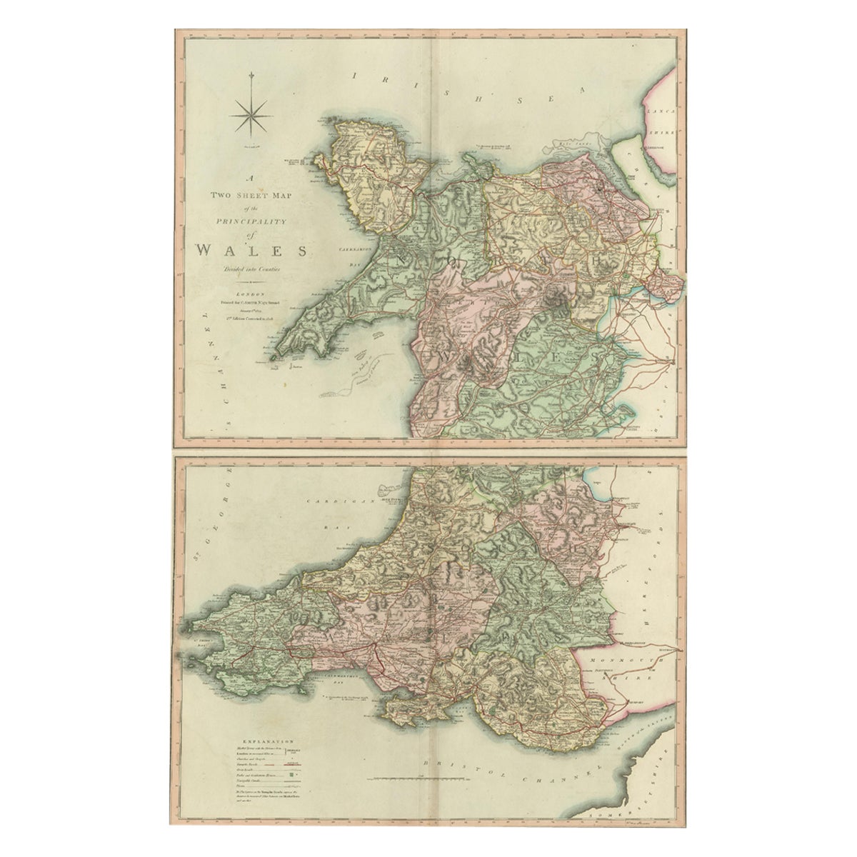
Two Sheet Map of the Principality of Wales Divided into Counties, 1804
Located in Langweer, NL
A well engraved and detailed large-scale map of Wales, printed on two sheets .
The map is thoroughly detailed and includes good information regarding t...
Category
Antique Early 1800s Maps
Materials
Paper
$523 Sale Price / set
20% Off
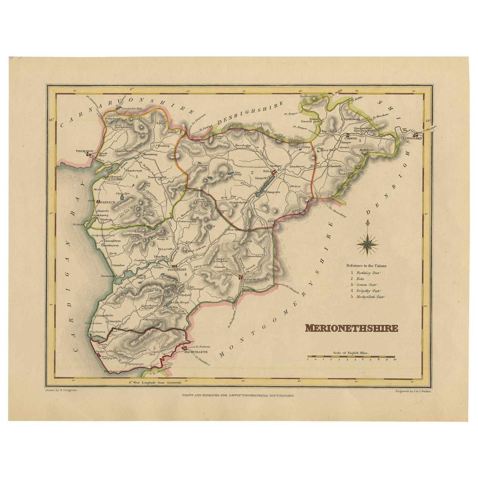
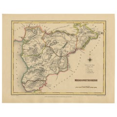
Old Map of Merionethshire by Lewis, 1844: Barmouth, Bala, Harlech, Dolgelley
Located in Langweer, NL
Old Map of Merionethshire by Samuel Lewis 1844 – Barmouth Bala Harlech Dolgelley
Description: This finely engraved hand-colored map of Merionethshire was published in 1844 for Samu...
Category
Antique 1840s Maps
Materials
Paper
$228 Sale Price
20% Off
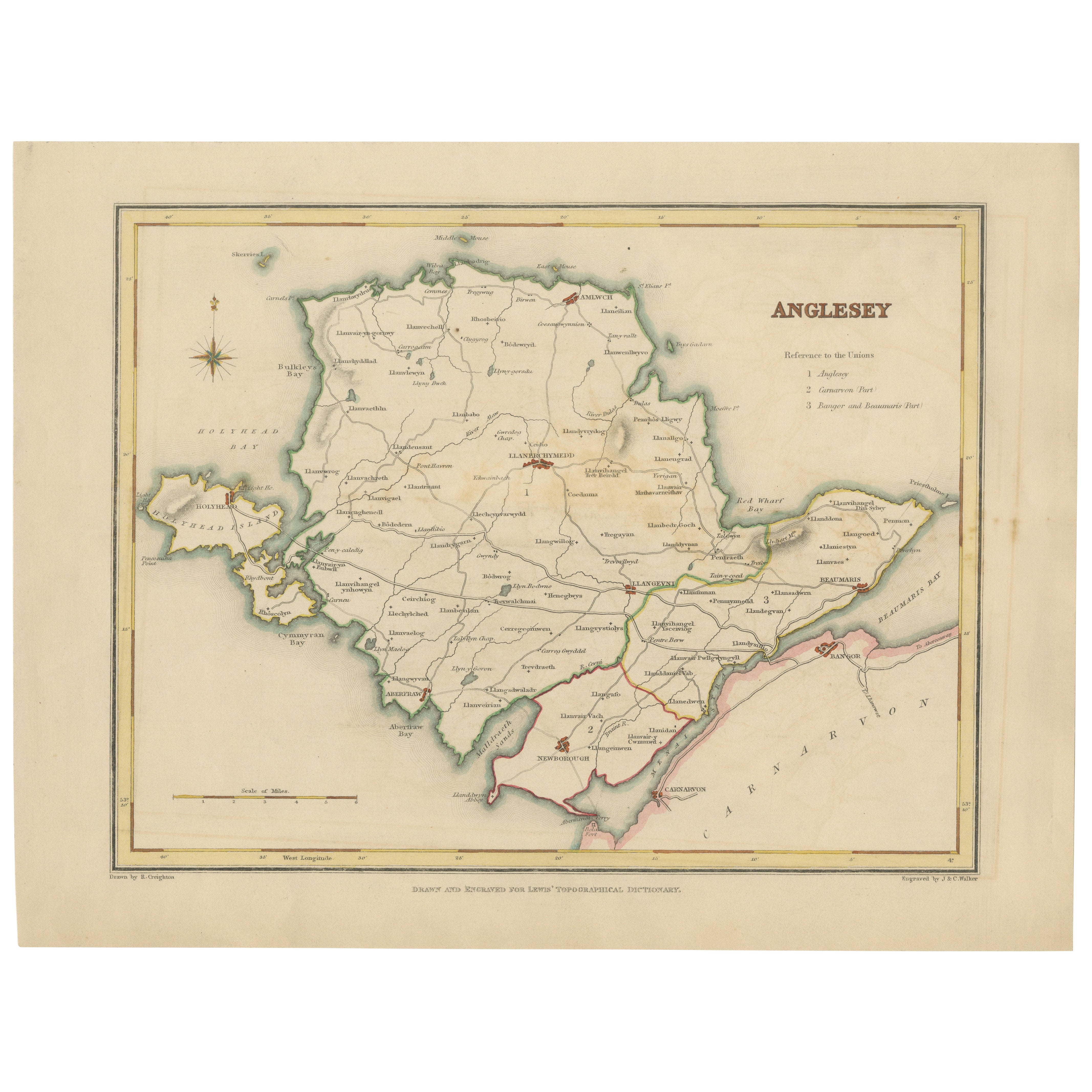
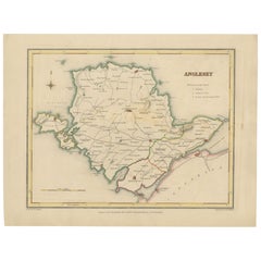
Old Map of Anglesey 1844 – Beaumaris Holyhead Llanerchymedd Amlwch Llangefni
Located in Langweer, NL
Title: Old Map of Anglesey by Samuel Lewis 1844 – Beaumaris Holyhead Llanerchymedd Amlwch Llangefni
Description: This antique 1844 map of Anglesey was drawn and engraved for Samuel ...
Category
Antique 1840s Maps
Materials
Paper
$209 Sale Price
20% Off
You May Also Like
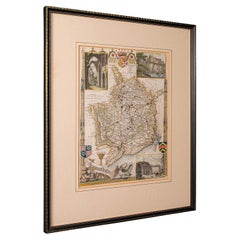
Original Antique English County Map - Monmouthshire. J & C Walker. 1851
Located in St Annes, Lancashire
Great map of Monmouthshire
Original colour
By J & C Walker
Published by Longman, Rees, Orme, Brown & Co. 1851
Unframed.
Category
Antique 1850s English Other Maps
Materials
Paper

Map North Wales Robert Marsden Anglesey
Located in BUNGAY, SUFFOLK
Map of North Wales by Robert Marsden
Including Anglesey
Charming topography and detail and colouring
just purchased more information to follow.
Category
Antique 18th Century English Georgian Maps
Materials
Paper

Antique Lithography Map, Monmouthshire, Framed, Welsh Cartography, Victorian
Located in Hele, Devon, GB
This is an antique lithography map of Monmouthshire. An English, framed atlas engraving of cartographic interest, dating to the mid 19th century and later.
Superb lithography of Mo...
Category
Antique Mid-19th Century British Victorian Maps
Materials
Glass, Wood, Paper
1851 Map of "Independent Tartary", Ric. R018
Located in Norton, MA
1851 Map of
Independent Tartary
"Russia"
Ric.r018
A highly decorative 1851 map of Independent Tartary by John Tallis and John Rapkin. Covers the regions between the Caspian Sea and Lake Bakquash and between Russia and Afghanistan. These include the ancient Silk Route kingdoms of Khiva, Tartaria, Kokand, and Bokhara. Today this region roughly includes Kazakhstan, Uzbekistan, Turkmenistan, Kyrgyzstan, and Tajikistan. This wonderful map offers a wealth of detail for anyone with an interest in the Central Asian portion of the ancient Silk Road. Identifies various caravan routes, deserts, wells, and stopping points, including the cities of Bokhara and Samarkand. Three vignettes by W. Bragg decorate the map, these including an image of Tartars on a Journey, a horseback Bride Chase, and a tartar camp site. Surrounded by a vine motif border. Engraved by J. Rapkin for John Tallis's 1851 Illustrated Atlas .
Tartary Antique Map...
Category
Antique 19th Century Unknown Maps
Materials
Paper

Large Original Antique Map of the Environs of Cork, Ireland, circa 1880
Located in St Annes, Lancashire
Great map of The Environs of Cork
Published circa 1880
Unframed
Free shipping.
Category
Antique 1880s Scottish Maps
Materials
Paper
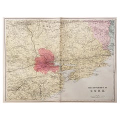
Original Antique English County Map, Herefordshire, J & C Walker, 1851
Located in St Annes, Lancashire
Great map of Herefordshire
Original colour
By J & C Walker
Published by Longman, Rees, Orme, Brown & Co. 1851
Unframed.
Category
Antique 1850s English Other Maps
Materials
Paper

More Ways To Browse
Antique Ivory Collectables
Used Furniture North Bay
Antique Gold Compass
Compass Rose Gold
Silver Bowl Large
Down Couch
Used Lighter Art
Blue Edge Glass
Mahogany 1950s Furniture
Solid Mahogany Table
Dessert Glasses
Geometric Glass Table
Mid Century Pin
6x10 Rug
Studded Furniture
Styles Of Antique Desks
Black And White Coffee Table
Metal Relief