Items Similar to Old Map of the New Philippines – Early 18th Century Spanish East Indies, 1706


Want more images or videos?
Request additional images or videos from the seller
1 of 10
Old Map of the New Philippines – Early 18th Century Spanish East Indies, 1706
$524.36
£388.33
€440
CA$722.42
A$803.21
CHF 422.94
MX$9,745.33
NOK 5,354.60
SEK 5,005.25
DKK 3,349.21
About the Item
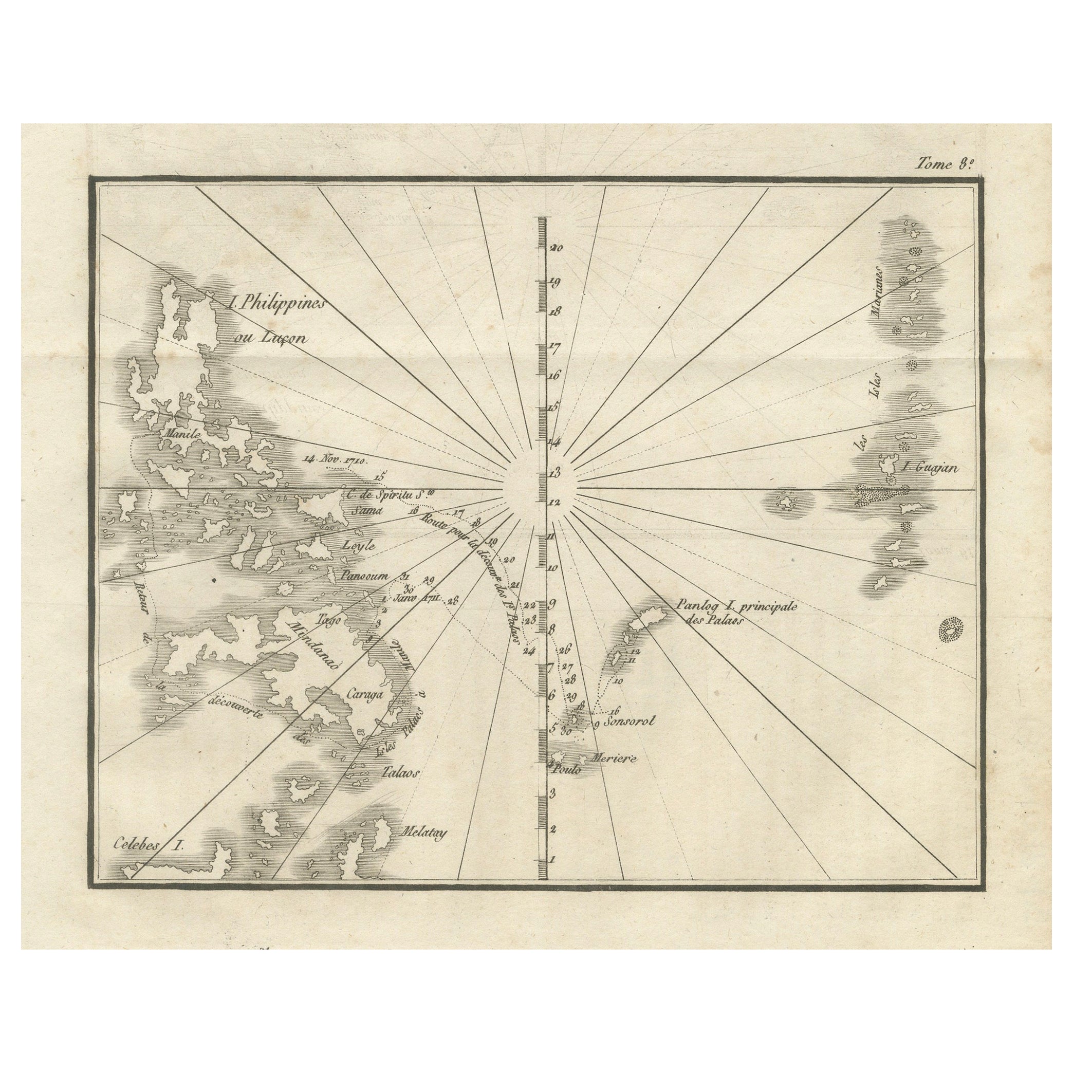
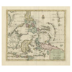
Map of the New Philippines – “Carte des Nouvelles Philippines”, 1706
This 18th-century copperplate map, titled Carte des Nouvelles Philippines, depicts the island chain referred to as the “New Philippines,” discovered under the auspices of King Philip V of Spain (Philippe V, Roy d’Espagne). Dated 1706 in the upper right, the map shows the region in the western Pacific that includes parts of today’s southern Philippines, the easternmost islands of Indonesia (Moluccas), and scattered islands of Micronesia.
The western side of the map features portions of Mindanao (Isle de Mindanao), Samal, and surrounding islands, as well as the Moluccas (Isles Moluques) and the island of Gilolo (Halmahera). Extending eastward, the chart plots numerous small islands, each named in French transliteration from local or Spanish forms, such as Panloy, Leto, Taldap, Sabos, Amaroot, and Parom. The Equator (Ligne Equinoctiale) is marked across the southern section, with islands like Parwin, Ulter, and various groups to the north and east.
The map is oriented with north at the top and is drawn in a style typical of early 18th-century European maritime exploration charts, with an emphasis on island positions rather than inland features. Its geographic coverage reflects Spanish and Jesuit missionary interest in this remote and relatively little-known part of the Pacific, linking it to the Manila galleon trade routes and Spain’s colonial ambitions in Asia and Oceania.
Marked “Tome 8, N° 1” in the upper right, this plate was part of a multi-volume travel and exploration series, engraved to bring new geographic discoveries to a European readership.
Condition: Very good for age, with a central fold as issued. Minor toning and light foxing in margins. Strong plate impression with clear lettering and fine island detail.
Framing tips: A black or dark walnut frame with an ivory mount will draw attention to the crisp island outlines and historical character. This map pairs well with other 18th-century Pacific and Southeast Asian charts.
Technique: Copperplate engraving
Maker: French school, c.1706–1760
- Dimensions:Height: 7.88 in (20 cm)Width: 9.22 in (23.4 cm)Depth: 0.01 in (0.2 mm)
- Materials and Techniques:Paper,Engraved
- Place of Origin:
- Period:
- Date of Manufacture:circa 1706
- Condition:Condition: Very good for age, with a central fold as issued. Minor toning and light foxing in margins. Strong plate impression with clear lettering and fine island detail.
- Seller Location:Langweer, NL
- Reference Number:Seller: BG-14078-321stDibs: LU3054346218172
About the Seller
5.0
Recognized Seller
These prestigious sellers are industry leaders and represent the highest echelon for item quality and design.
Platinum Seller
Premium sellers with a 4.7+ rating and 24-hour response times
Established in 2009
1stDibs seller since 2017
2,569 sales on 1stDibs
Typical response time: <1 hour
- ShippingRetrieving quote...Shipping from: Langweer, Netherlands
- Return Policy
Authenticity Guarantee
In the unlikely event there’s an issue with an item’s authenticity, contact us within 1 year for a full refund. DetailsMoney-Back Guarantee
If your item is not as described, is damaged in transit, or does not arrive, contact us within 7 days for a full refund. Details24-Hour Cancellation
You have a 24-hour grace period in which to reconsider your purchase, with no questions asked.Vetted Professional Sellers
Our world-class sellers must adhere to strict standards for service and quality, maintaining the integrity of our listings.Price-Match Guarantee
If you find that a seller listed the same item for a lower price elsewhere, we’ll match it.Trusted Global Delivery
Our best-in-class carrier network provides specialized shipping options worldwide, including custom delivery.More From This Seller
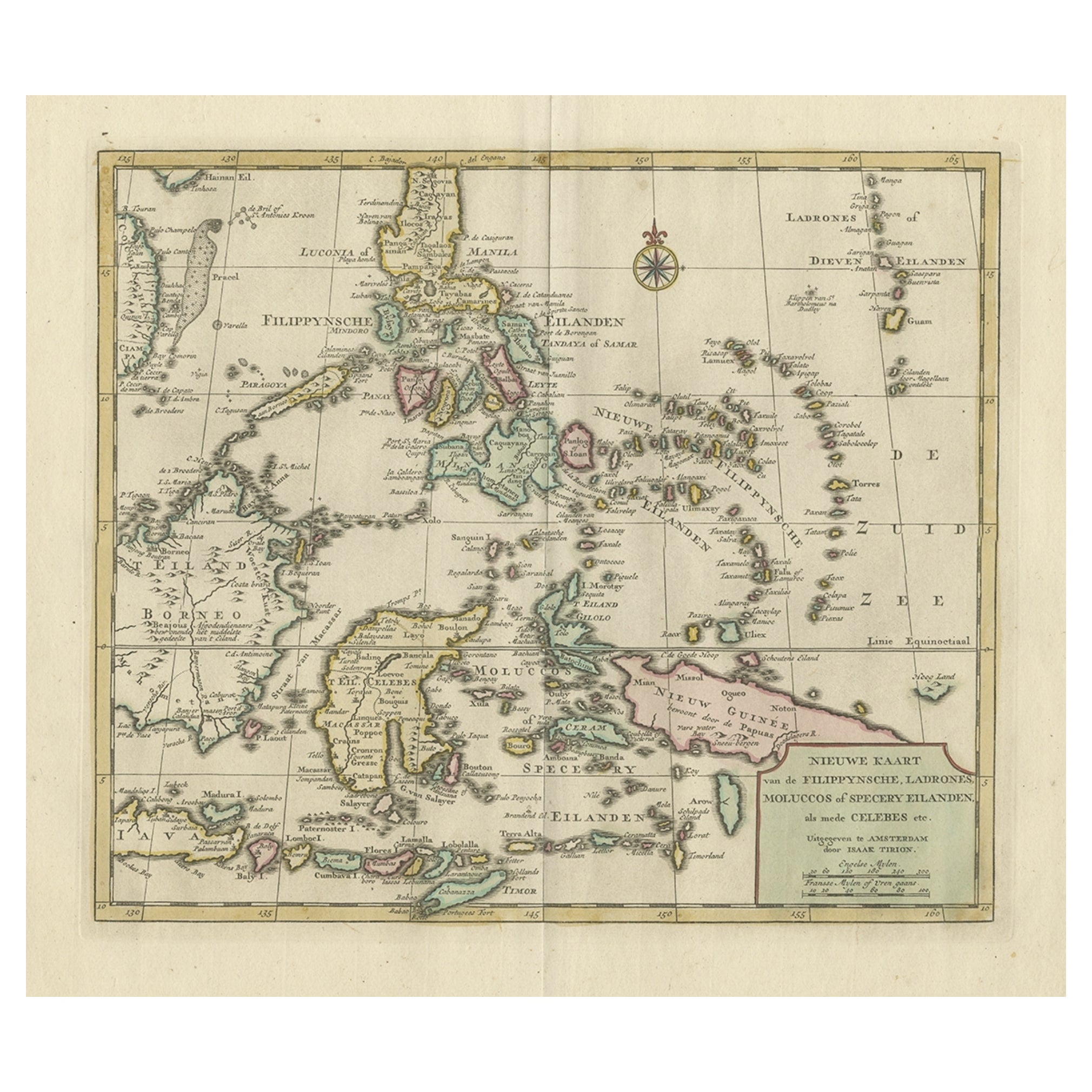
View AllOld Map of the Philippines and Part of Indonesia 'Spice Islands', 1744
Located in Langweer, NL
Antique map titled 'Nieuwe Kaart van de Filippynsche, Ladrones, Moluccos of Specery Eilanden, als mede Celebes etc'.
Old map of the Philippines and part of Indonesia. Originates ...
Category
Antique 1740s Maps
Materials
Paper

$629 Sale Price
20% Off
Old Original Map of the Philippines and Part of Indonesia 'Spice Islands', 1744
Located in Langweer, NL
Antique map titled 'Nieuwe Kaart van de Filippynsche, Ladrones, Moluccos of Specery Eilanden, als mede Celebes etc'.
Old map of the Philippines and part of Indonesia. Originates ...
Category
Antique 1740s Maps
Materials
Paper
$886 Sale Price
20% Off
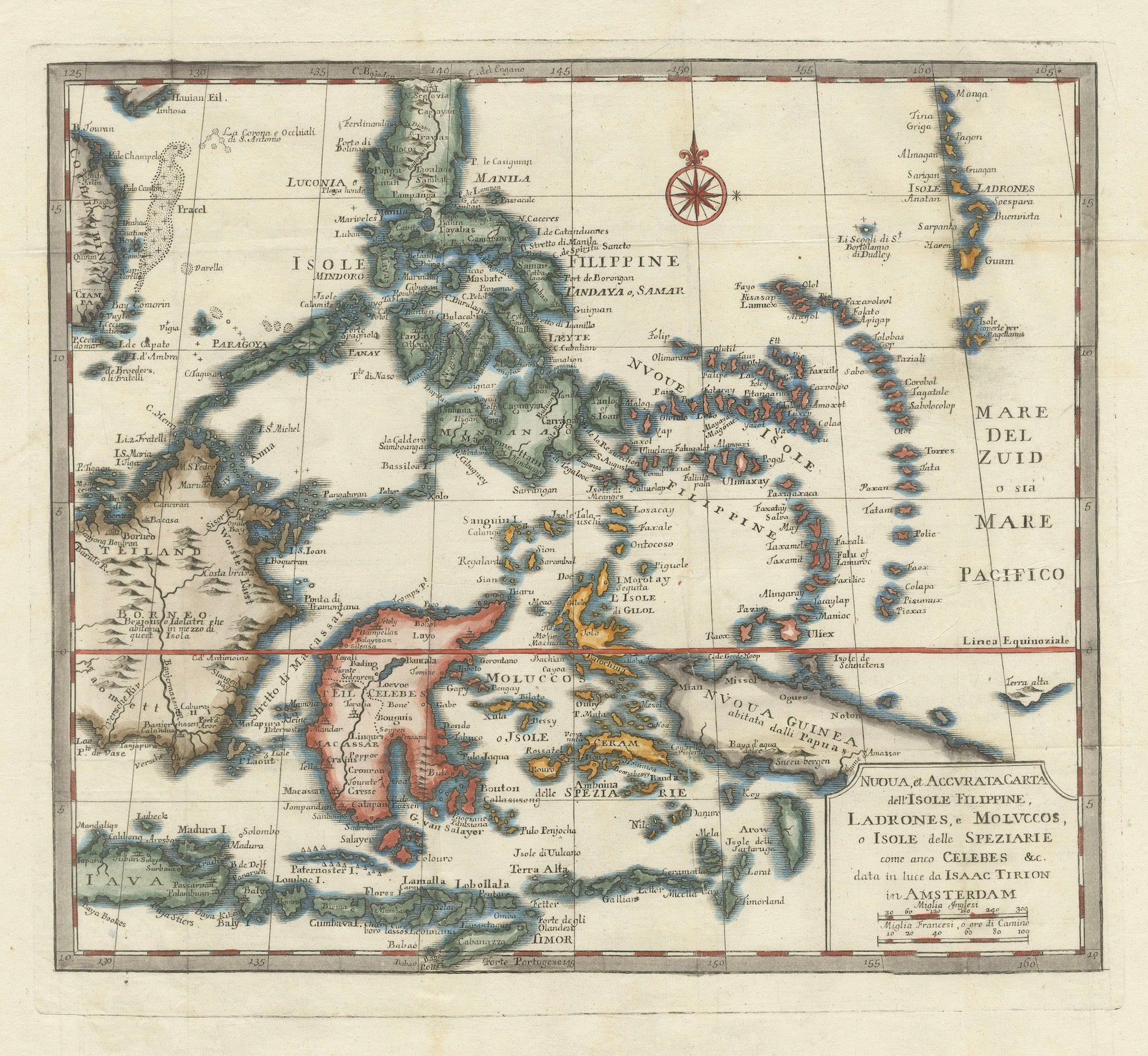
1738 Map of the Philippines & Eastern Indonesia: Spice Islands by Tirion
Located in Langweer, NL
1738 Map of the Philippines & Eastern Indonesia: Spice Islands by Tirion/Albrizzi
This beautifully hand-colored map from circa 1738, created by Tirion and Albrizzi, showcases the Philippines and the eastern part of Indonesia, reflecting the Dutch colonial interests in the region.
The map features a detailed representation of the numerous islands, including the renowned Spice or Banda Islands, pivotal to the Dutch spice trade.
Key regions include the Philippines (Isole Filippine), the Mariana Islands (Ladrones), with Guam, the Caroline and Palau Islands (Nieuwe Fillippynsche Eilenden), the Moluccas (Moluccos) known as the Spice Islands, the eastern tip of Java and Borneo, and a portion of Papua New Guinea.
Measuring 12.8 inches wide by 11.1 inches high, the map is in excellent condition with a crisp impression, slight foxing, and minor printer's creases, printed on a bright sheet with a lion watermark.
Keywords:
- Philippines historical map
- Eastern Indonesia map...
Category
Antique 1730s Maps
Materials
Paper

Map of the Philippines and Palau Islands – Antique French Engraving, c.1790
Located in Langweer, NL
Map of the Philippines and Palau Islands – Antique French Engraving, c.1790
This antique French maritime chart depicts the western Pacific region between the Philippines and the Pal...
Category
Antique Late 18th Century French Maps
Materials
Paper
Antique Map of the Northern Portion of the Philippines by J.N. Bellin, 1764
Located in Langweer, NL
Detailed map of the Northern portion of the Philippines, extending from Batanes and Babuyanes to Mindonoro and Masbate, and centered on Luzon. One of the most detailed maps of the pe...
Category
Antique Mid-18th Century Maps
Materials
Paper

$262 Sale Price
16% Off
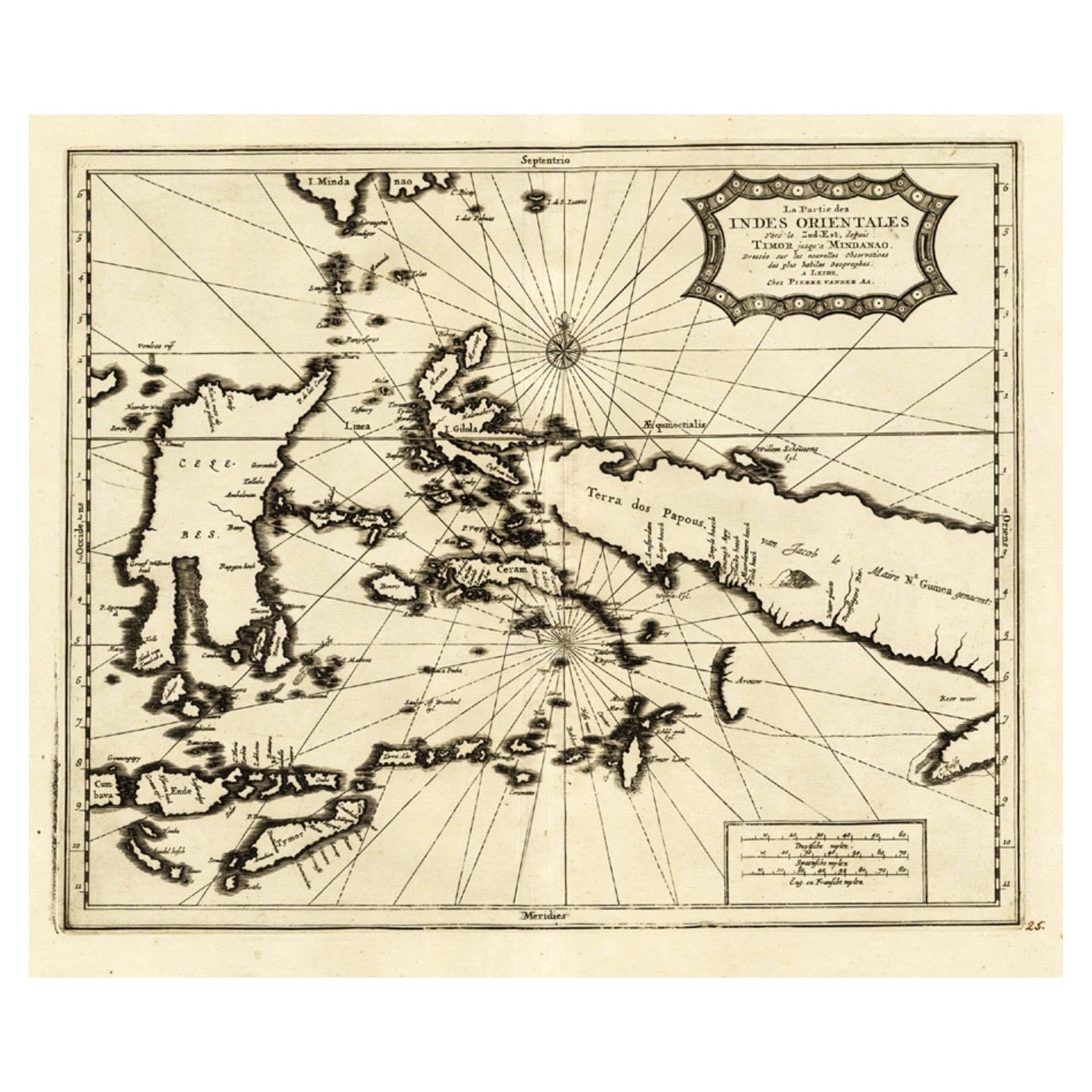
Extremely Rare Map of the East-Indies towards the South-East 'Indonesia', 1725
Located in Langweer, NL
Antique map titled 'La partie des Indes Orientales vers le Zud-Est, depuis Timor jusqu'a Midanao (...).' (The part of the East-Indies towards the South-East, from Timor to Mindanao.)...
Category
Antique 1720s Maps
Materials
Paper
$1,096 Sale Price
20% Off
You May Also Like
Original Antique Map of The Philippines. C.1900
Located in St Annes, Lancashire
Fabulous map of The Philippines
Original color.
Engraved and printed by the George F. Cram Company, Indianapolis.
Published, C.1900.
Unframed.
Free shipping.
Category
Antique 1890s American Maps
Materials
Paper

Original Antique Map of South East Asia by Thomas Clerk, 1817
Located in St Annes, Lancashire
Great map of South East Asia
Copper-plate engraving
Drawn and engraved by Thomas Clerk, Edinburgh.
Published by Mackenzie And Dent, 1817
Unframed.
Category
Antique 1810s English Maps
Materials
Paper

Antique French Map of Asia Including China Indoneseia India, 1783
Located in Amsterdam, Noord Holland
Very nice map of Asia. 1783 Dedie au Roy.
Additional information:
Country of Manufacturing: Europe
Period: 18th century Qing (1661 - 1912)
Condition: Overall Condition B (Good Used)...
Category
Antique 18th Century European Maps
Materials
Paper

$648 Sale Price
20% Off
Map of the East Indies: An Original 18th Century Hand-colored Map by E. Bowen
Located in Alamo, CA
This is an original 18th century hand-colored map entitled "An Accurate Map of the East Indies Exhibiting the Course of the European Trade both on the Continent and Islands" by Emanu...
Category
Mid-18th Century Old Masters Landscape Prints
Materials
Engraving

Antique Map - Mare Pacificum - Etching by Johannes Janssonius - 1650s
By Johannes Janssonius
Located in Roma, IT
Mare Pacificum is an antique map realized in 1650 by Johannes Janssonius (1588-1664).
The Map is Hand-colored etching, with coeval watercolorang.
Good conditions with slight foxing...
Category
1650s Modern Figurative Prints
Materials
Etching

Antique 1803 Italian Map of Asia Including China Indoneseia India
Located in Amsterdam, Noord Holland
Antique 1803 Italian Map of Asia Including China Indoneseia India
Very nice map of Asia. 1803.
Additional information:
Type: Map
Country of Manufacturing: Europe
Period: 19th centu...
Category
Antique 19th Century European Maps
Materials
Paper

$584 Sale Price
20% Off