Items Similar to Original Antique Map of the American State of New Jersey, 1903

Want more images or videos?
Request additional images or videos from the seller
1 of 5
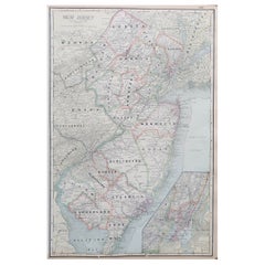
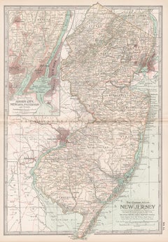
Original Antique Map of the American State of New Jersey, 1903
$49
£36.81
€42.45
CA$67.99
A$75.56
CHF 39.59
MX$926.56
NOK 504.98
SEK 475.06
DKK 316.81
Shipping
Retrieving quote...The 1stDibs Promise:
Authenticity Guarantee,
Money-Back Guarantee,
24-Hour Cancellation
About the Item
Antique map of New Jersey
Published By A & C Black. 1903
Original colour
Good condition
Unframed.
Free shipping
- Dimensions:Height: 16.25 in (41.28 cm)Width: 11.5 in (29.21 cm)Depth: 0.07 in (1.78 mm)
- Materials and Techniques:Paper,Other
- Place of Origin:
- Period:1900-1909
- Date of Manufacture:1903
- Condition:Wear consistent with age and use.
- Seller Location:St Annes, GB
- Reference Number:1stDibs: LU1836343723932
About the Seller
4.9
Platinum Seller
Premium sellers with a 4.7+ rating and 24-hour response times
1stDibs seller since 2016
3,113 sales on 1stDibs
Typical response time: 1 hour
Associations
International Confederation of Art and Antique Dealers' Associations
- ShippingRetrieving quote...Shipping from: St Annes, United Kingdom
- Return Policy
Authenticity Guarantee
In the unlikely event there’s an issue with an item’s authenticity, contact us within 1 year for a full refund. DetailsMoney-Back Guarantee
If your item is not as described, is damaged in transit, or does not arrive, contact us within 7 days for a full refund. Details24-Hour Cancellation
You have a 24-hour grace period in which to reconsider your purchase, with no questions asked.Vetted Professional Sellers
Our world-class sellers must adhere to strict standards for service and quality, maintaining the integrity of our listings.Price-Match Guarantee
If you find that a seller listed the same item for a lower price elsewhere, we’ll match it.Trusted Global Delivery
Our best-in-class carrier network provides specialized shipping options worldwide, including custom delivery.More From This Seller
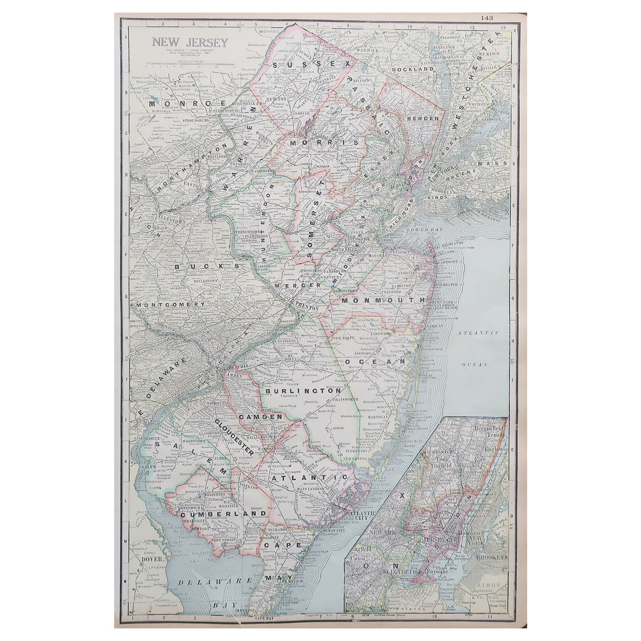
View AllLarge Original Antique Map of New Jersey, USA, circa 1900
Located in St Annes, Lancashire
Fabulous map of New Jersey
Original color
Engraved and printed by the George F. Cram Company, Indianapolis.
Published, circa 1900
Unframed
Repairs to minor edge tears
Category
Antique 1890s American Maps
Materials
Paper
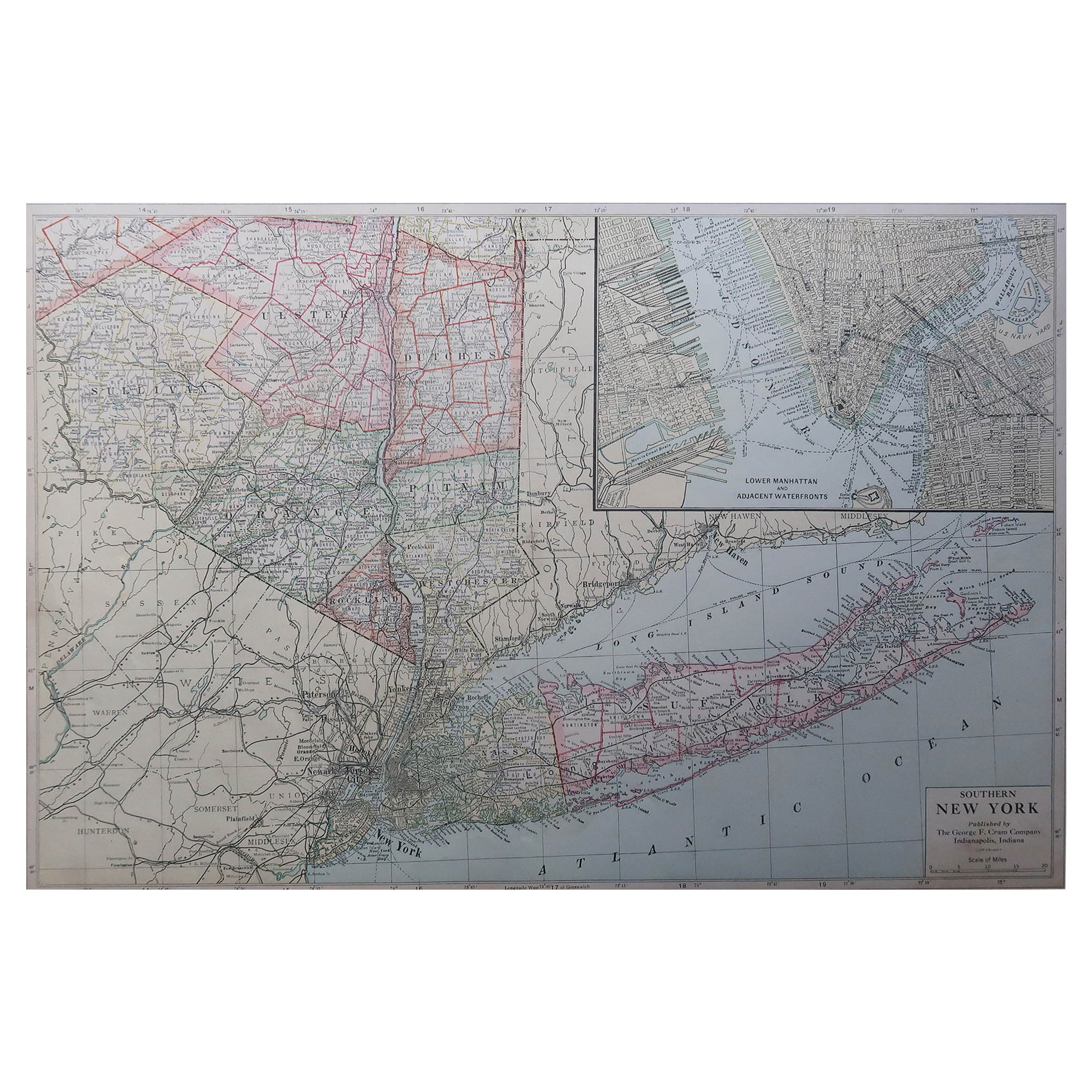
Large Original Antique Map of New York State( Southern ), USA, C.1900
Located in St Annes, Lancashire
Fabulous map of Southern New York . With a vignette of Lower Manhattan
Original color.
Engraved and printed by the George F. Cram Company, Indianapolis.
Published, C.1900.
Unfram...
Category
Antique 1890s American Maps
Materials
Paper

Original Antique Map of the American State of New York ( Western Part ) 1903
Located in St Annes, Lancashire
Antique map of New York ( Western Part )
Published By A & C Black. 1903
Original colour
Good condition
Unframed.
Free shipping
Category
Antique Early 1900s English Maps
Materials
Paper

Original Antique Map of the American State of Pennsylvania( Eastern Part ), 1903
Located in St Annes, Lancashire
Antique map of Pennsylvania ( Eastern part )
Published By A & C Black. 1903
Original colour
Good condition
Unframed.
Free shipping
Category
Antique Early 1900s English Maps
Materials
Paper

Original Antique Map of the American State of New York ( Southern Part ) 1903
Located in St Annes, Lancashire
Antique map of New York ( Southern Part )
Published By A & C Black. 1903
Original colour
Good condition
Unframed.
Free shipping
Category
Antique Early 1900s English Maps
Materials
Paper

Original Antique Map of the American State of Connecticut & Rhode Island, 1903
Located in St Annes, Lancashire
Antique map of Connecticut and Rhode Island
Published By A & C Black. 1903
Original colour
Good condition
Unframed.
Free shipping
Category
Antique Early 1900s English Maps
Materials
Paper

You May Also Like
Antique Map of New Jersey
Located in Langweer, NL
Antique map titled 'Colton's New Jersey'. This rare hand colored map of New Jersey is a copper plate engraving dating to 1855. Produced by the import...
Category
Antique Mid-19th Century Maps
Materials
Paper

$192 Sale Price
20% Off
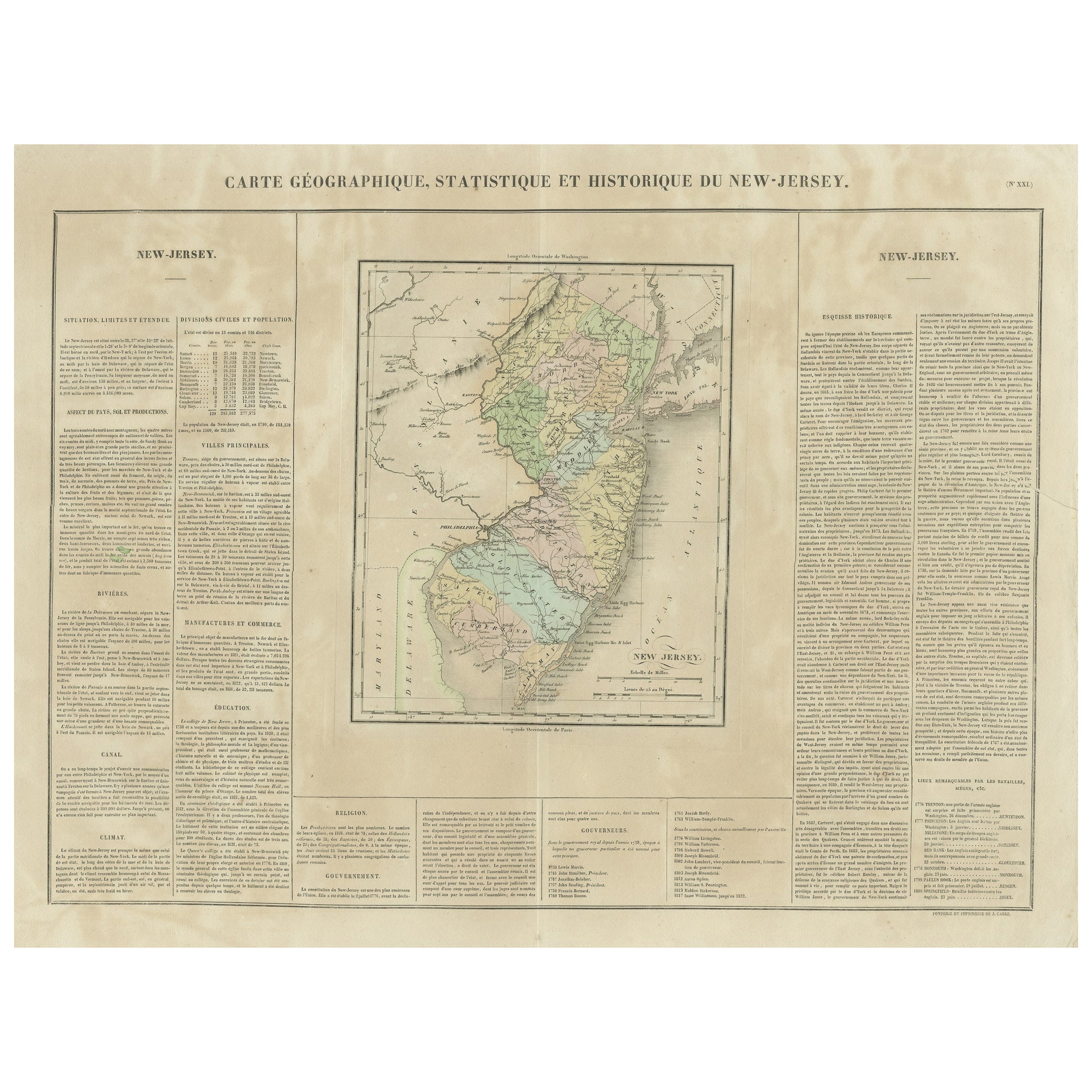
Original Antique Map of the State of New Jersey Published in France
Located in Langweer, NL
Original antique map titled 'Carte Géographique Statistique et Historique du New-Jersey'. One of the earliest obtainable maps of the State of New Jersey published outside of the Unit...
Category
Antique Early 19th Century Maps
Materials
Paper
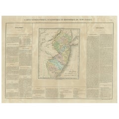
$192 Sale Price
20% Off
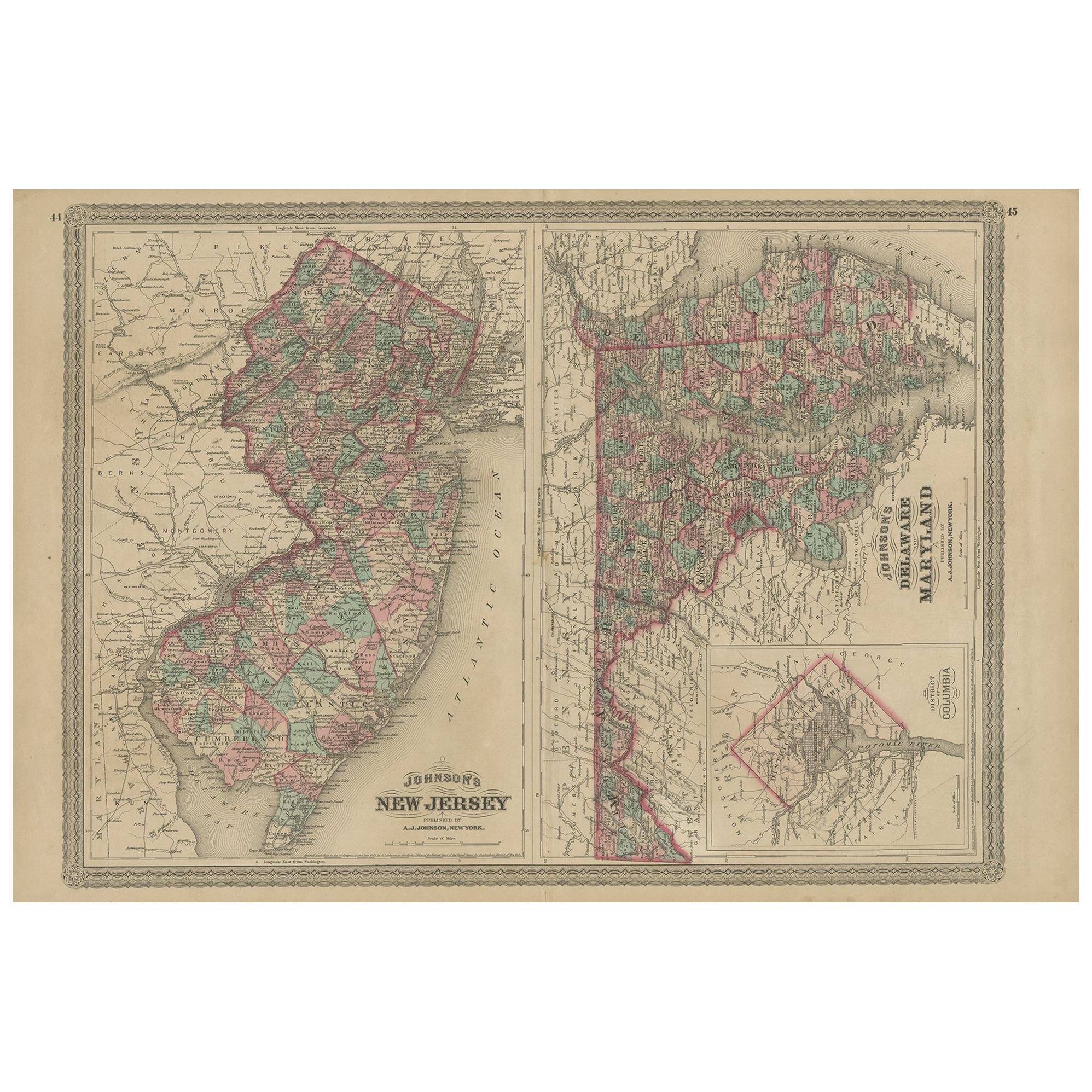
Antique Map of New Jersey, Delaware and Maryland by Johnson, 1872
Located in Langweer, NL
Antique map titled 'Johnson's New Jersey (..). Two maps on one sheet showing New Jersey, Delaware and Maryland. With inset map of the district of Columbia...
Category
Antique Late 19th Century Maps
Materials
Paper
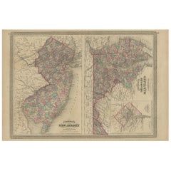
$288 Sale Price
20% Off
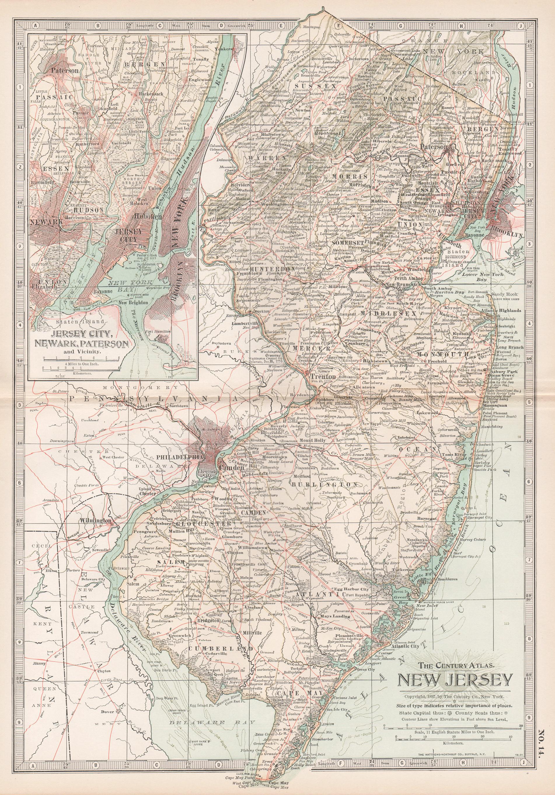
New Jersey. USA Century Atlas state antique vintage map
Located in Melbourne, Victoria
'The Century Atlas. New Jersey'
Original antique map, 1903.
Central fold as issued. Map name and number printed on the reverse corners.
Sheet 40cm by 29.5cm.
Category
Early 20th Century Victorian More Prints
Materials
Lithograph
Antique Map of Pennsylvania and New Jersey by Johnson, 1872
Located in Langweer, NL
Antique map titled 'Johnson's Pennsylvania and New Jersey'. Original map showing Pennsylvania and New Jersey. This map originates from 'Johnson's New Illustrated Family Atlas of the ...
Category
Antique Late 19th Century Maps
Materials
Paper

$240 Sale Price
20% Off
1872 Map of Hudson, Union and Essex Counties, New Jersey
Located in Savannah, GA
A hand-colored topographical map of New Jersey’s Hudson, Union and Essex Counties from the Atlas of New Jersey by F.W. Beers, published in 1872.
sight 15 by 22½ inches
frame 20 by...
Category
Antique 1870s American Prints
Materials
Glass, Wood, Paper

More Ways To Browse
Post Modern High Chairs
Vintage Vine Rug
Silver Metal Chair
Swedish Kilim
Vintage Scandanavian Chairs
Vintage Tropical Furniture
19th Century Red Glass
Antique French Console Table Tables
French 50s
Rusted Metal Art
Silver Bowl Large
Antique French Silk
Down Couch
Cobalt Blue Glass
Used Lighter Art
Blue Edge Glass
Mahogany 1950s Furniture
Solid Mahogany Table