Items Similar to Plan of Poulo Condore (Côn Sơn Island) – Antique French Engraving, ca.1790

Want more images or videos?
Request additional images or videos from the seller
1 of 10
Plan of Poulo Condore (Côn Sơn Island) – Antique French Engraving, ca.1790
$402.98
£300.02
€340
CA$555.25
A$618.27
CHF 326.95
MX$7,523.91
NOK 4,121.32
SEK 3,882.89
DKK 2,588.26
About the Item
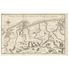
Plan of Poulo Condore (Côn Sơn Island) – Antique French Engraving by Portier, c.1790
This antique French engraving, created by Portier around 1790, presents a detailed plan of Poulo Condore, now known as Côn Sơn Island in Vietnam’s Côn Đảo archipelago. The title reads “Plan de l’Isle d’Orléans ou Poulo Condore,” and the map specifies the port’s coordinates at 8°43′ N latitude and 13° E longitude (Paris meridian).
The plan includes both natural and man-made features, labeled with letters corresponding to the key at the bottom:
A – The Port
B – The French Camp
C – Ruins of a fort built by the English
D – Village of the Islanders
E – Port entrance during the northeast monsoon
F – Port entrance during the southwest monsoon
The engraving’s coastal outline is finely rendered, with soundings indicated by numbers in the harbor and approaches. The depiction of seasonal port entrances reflects the island’s strategic maritime role and the navigational challenges presented by monsoonal winds in the South China Sea.
Poulo Condore has a long and complex history as a trading outpost, penal colony, and strategic anchorage. In the 18th century, it attracted European powers, including the French and English, for its position along major sea routes between India, China, and Southeast Asia. The ruined English fort noted here is a reminder of the island’s contested colonial past.
This engraving was likely published in a French geographical or missionary work documenting Asian maritime territories, contributing to Enlightenment-era European knowledge of the region.
Condition report: Very good condition with a clear plate mark and strong impression. Minor toning and faint foxing in the margins. Central fold as issued. Paper is stable and well-preserved.
Framing tips: Best presented in a slim black or dark brown frame with a cream archival mat. A double mat with a fine blue-grey inner line could complement the maritime theme.
Technique: Engraving
Maker: Portier, France, c.1790
- Dimensions:Height: 5.83 in (14.8 cm)Width: 7.88 in (20 cm)Depth: 0.01 in (0.2 mm)
- Materials and Techniques:Paper,Engraved
- Place of Origin:
- Period:
- Date of Manufacture:circa 1790
- Condition:Condition report: Very good condition with a clear plate mark and strong impression. Minor toning and faint foxing in the margins. Central fold as issued. Paper is stable and well-preserved.
- Seller Location:Langweer, NL
- Reference Number:Seller: BG-14078-201stDibs: LU3054346211442
About the Seller
5.0
Recognized Seller
These prestigious sellers are industry leaders and represent the highest echelon for item quality and design.
Platinum Seller
Premium sellers with a 4.7+ rating and 24-hour response times
Established in 2009
1stDibs seller since 2017
2,567 sales on 1stDibs
Typical response time: <1 hour
- ShippingRetrieving quote...Shipping from: Langweer, Netherlands
- Return Policy
Authenticity Guarantee
In the unlikely event there’s an issue with an item’s authenticity, contact us within 1 year for a full refund. DetailsMoney-Back Guarantee
If your item is not as described, is damaged in transit, or does not arrive, contact us within 7 days for a full refund. Details24-Hour Cancellation
You have a 24-hour grace period in which to reconsider your purchase, with no questions asked.Vetted Professional Sellers
Our world-class sellers must adhere to strict standards for service and quality, maintaining the integrity of our listings.Price-Match Guarantee
If you find that a seller listed the same item for a lower price elsewhere, we’ll match it.Trusted Global Delivery
Our best-in-class carrier network provides specialized shipping options worldwide, including custom delivery.More From This Seller
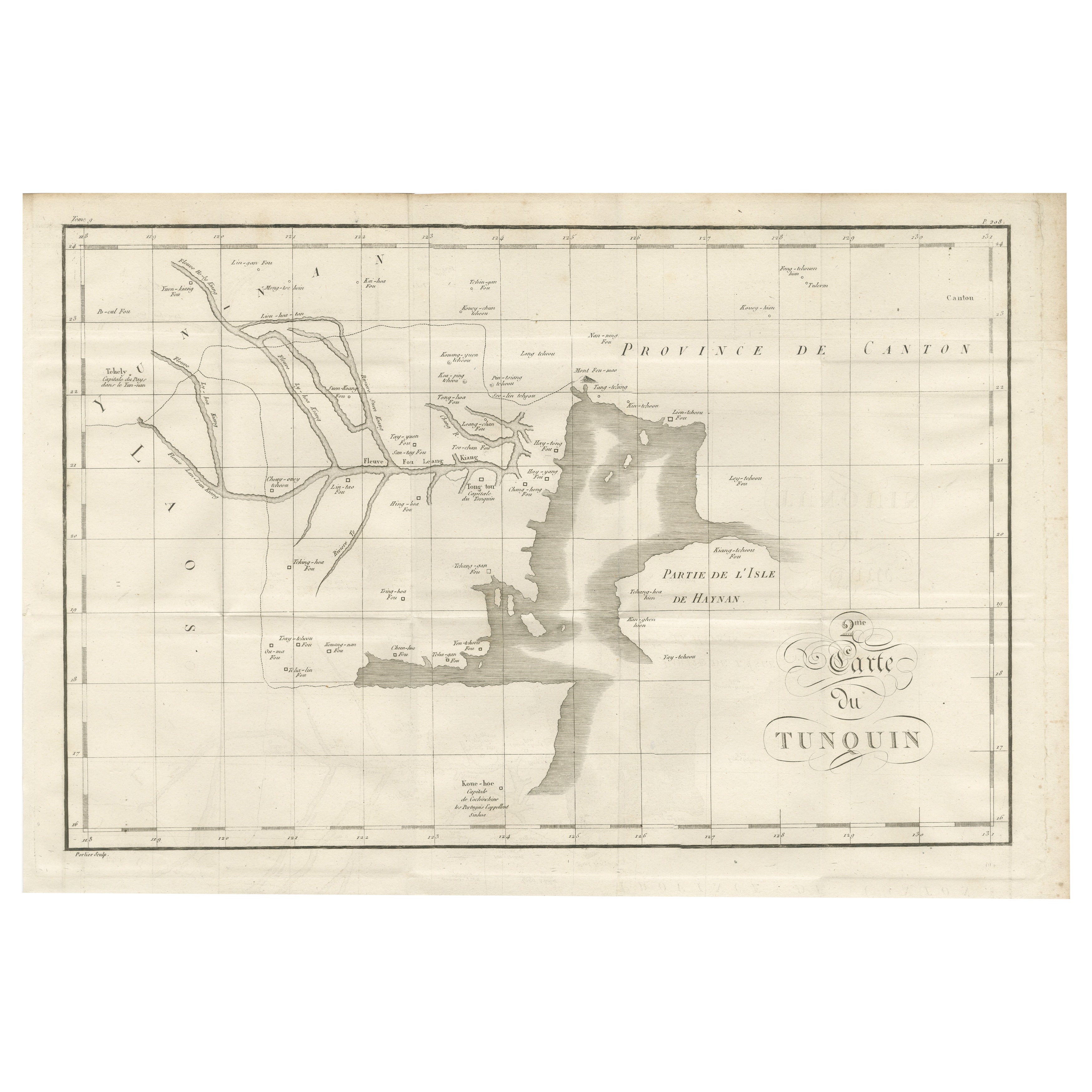
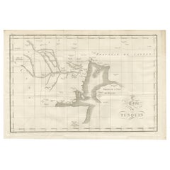
View AllAntique Map of Tonkin and Hainan Island – 18th Century French Engraving
Located in Langweer, NL
Antique Map of Tonkin and Hainan Island – 18th Century French Engraving
This is the “5me Carte du Tunquin,” an antique engraved map depicting the northern coastal region of modern-d...
Category
Antique Late 18th Century French Maps
Materials
Paper
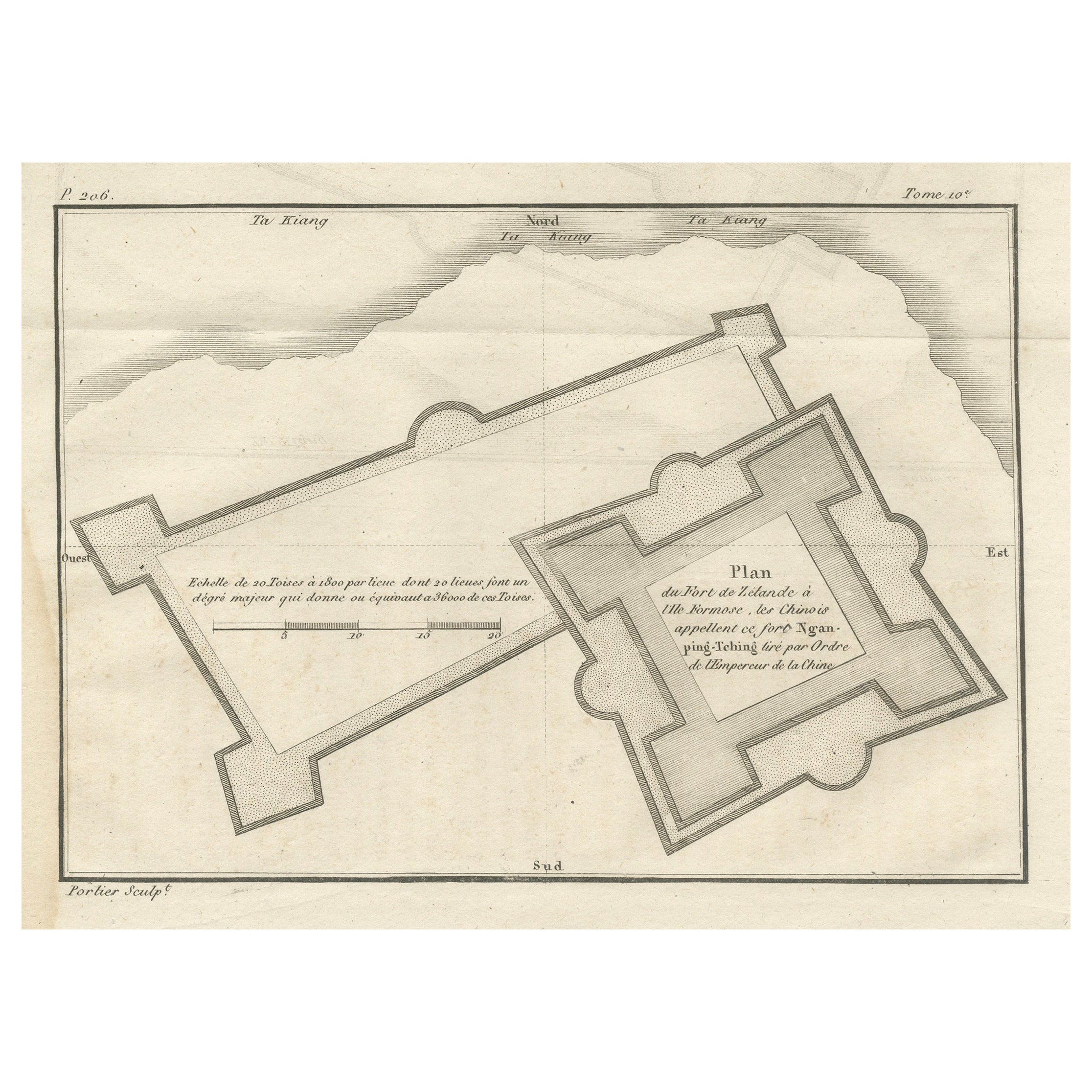
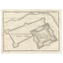
Plan of the Dutch Fort in Formosa – Antique French Jesuit Engraving, ca.1790
Located in Langweer, NL
Plan of the Dutch Fort in Formosa – Antique French Jesuit Engraving by Portier, c.1790
This antique French engraving by Portier, produced around 1790, shows a detailed plan of the D...
Category
Antique Late 18th Century French Maps
Materials
Paper
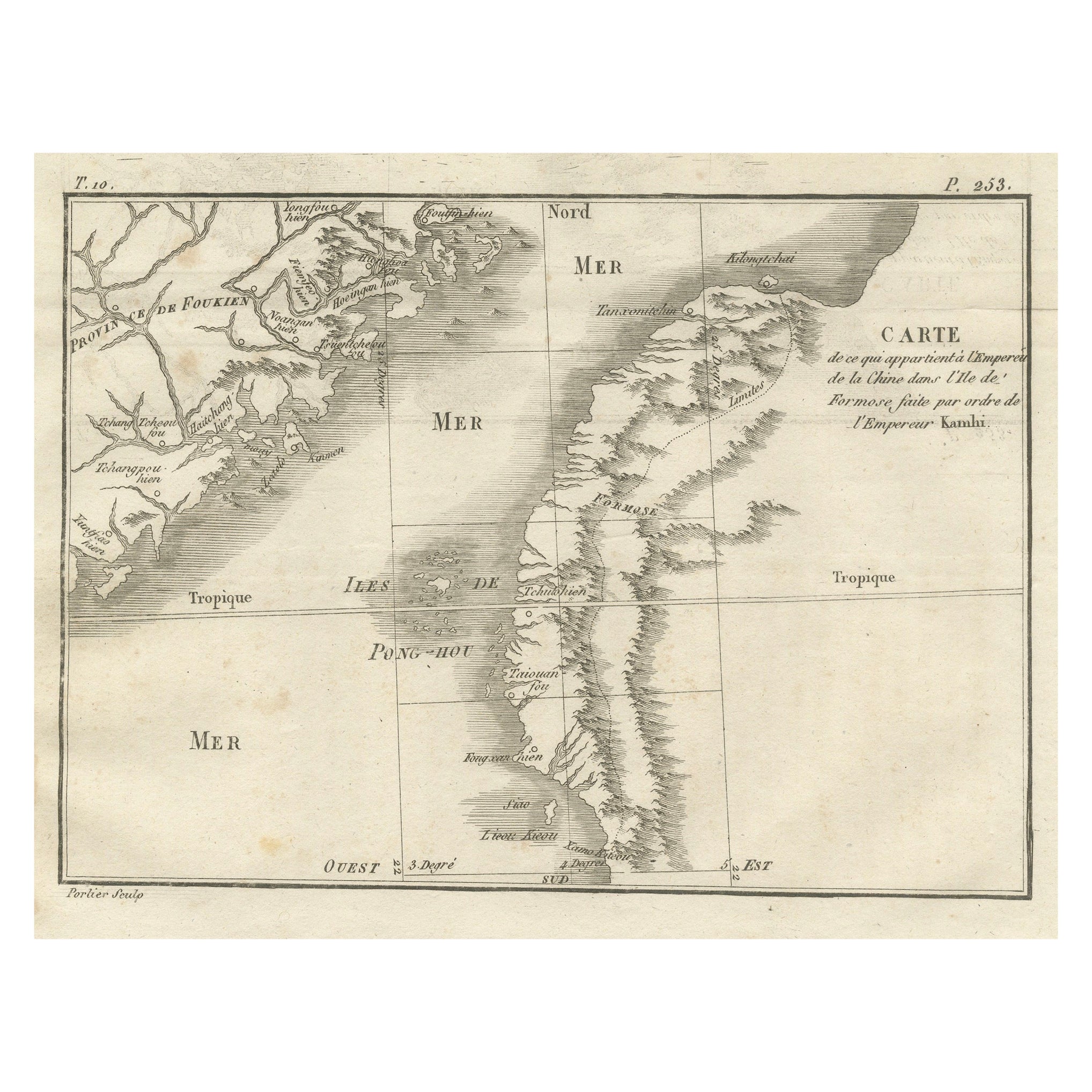
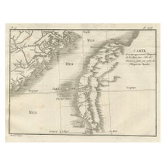
Map of Formosa and Pescadores – French Jesuit Engraving by Portier, c.1790
Located in Langweer, NL
Map of Formosa and Pescadores – French Jesuit Engraving by Portier, c.1790
This antique French map, engraved by Portier around 1790, depicts the island of Formosa (modern Taiwan), t...
Category
Antique Late 18th Century French Maps
Materials
Paper
Antique Map of the Environs of Cap-Français, Saint-Domingue, c.1760
Located in Langweer, NL
Antique Map of the Environs of Cap-Français, Saint-Domingue, c.1760
This detailed 18th-century copperplate engraving, titled Carte des Environs du Cap Français et des Paroisses qui ...
Category
Antique Early 18th Century French Maps
Materials
Paper
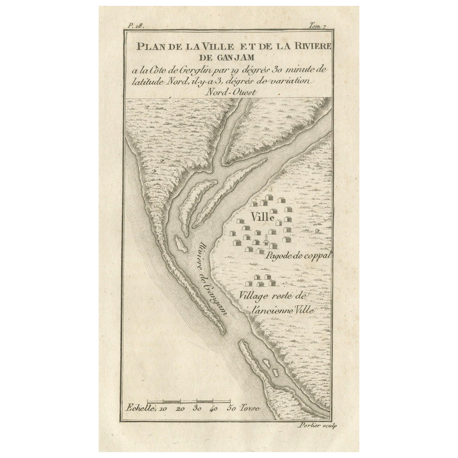
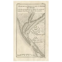
Plan of the Town and River of Ganjam, India – Antique French Map by Portier 1790
Located in Langweer, NL
Plan of the Town and River of Ganjam, India – Antique French Map by Portier, c.1790
This antique French engraving shows a detailed plan of the town and river of Ganjam, located on t...
Category
Antique Late 18th Century French Maps
Materials
Paper
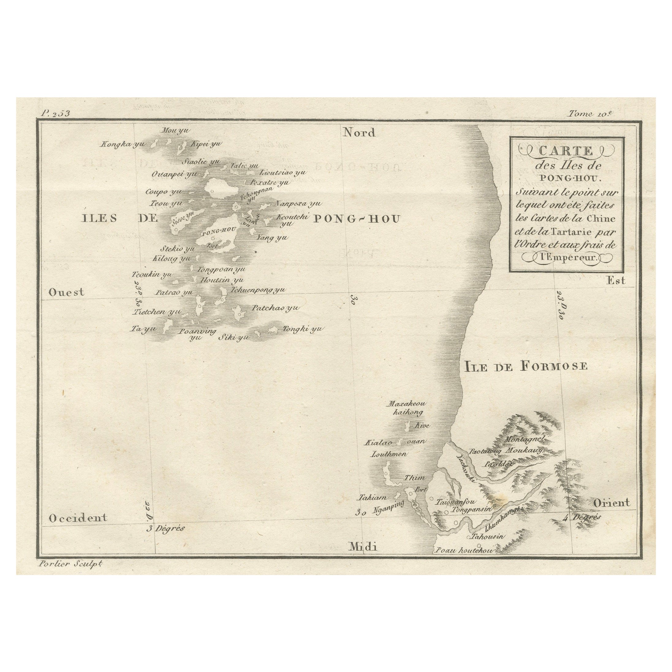
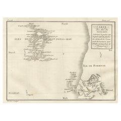
Map of Pescadores Islands (Pong-Hou) & Formosa – French Jesuit Engraving, 1790
Located in Langweer, NL
Map of the Pescadores Islands (Pong-Hou) and Formosa – French Jesuit Engraving by Portier, c.1790
This finely engraved French map, produced by Portier around 1790, depicts the Pesca...
Category
Antique Late 18th Century French Maps
Materials
Paper
You May Also Like
Plan of Port Siagi - Etching by Joseph Roux - 1795
Located in Roma, IT
Plan of Port Siagi is al colored etching realized by Joseph Roux in 1795.
The title at the top " Plan du Port Siagi"
Passepartout included: 34 x 49
The artwork is hand water-color...
Category
1790s Modern Figurative Prints
Materials
Etching

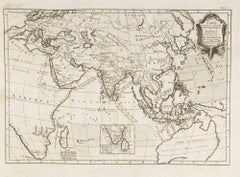
Antique French Map of Asia Including China Indoneseia India, 1783
Located in Amsterdam, Noord Holland
Very nice map of Asia. 1783 Dedie au Roy.
Additional information:
Country of Manufacturing: Europe
Period: 18th century Qing (1661 - 1912)
Condition: Overall Condition B (Good Used)...
Category
Antique 18th Century European Maps
Materials
Paper

$648 Sale Price
20% Off
Southerlandia Map - Etching by Johannes Janssonius - 1650
By Johannes Janssonius
Located in Roma, IT
Southerlandia Map is an ancient map realized in 1650 by Johannes Janssonius (1588-1664).
The Map is Hand-colored etching, with coeval watercoloring.
Good conditions.
From Atlantis...
Category
1650s Modern Figurative Prints
Materials
Etching

Carte Pour Servir a l'Histoire Philosophique.. - Etching by Rigobert Bonne- 1780
Located in Roma, IT
Etching on paper.
From Guillaume-Thomas Raynal, Histoire philosophique et politique des établissemens et du commerce des Européens dans les deux Indes, Geneva 1780.
This interestin...
Category
1780s Modern Figurative Prints
Materials
Etching
18th Century Map Engraving - Plan of the Works of the City of Messina, Sicily
Located in Corsham, GB
A map of Messina, a harbour city in northeast Sicily. Inscribed with the title in plate to the lower edge, 'Plan of the Works of the City of Messina, one of the strongest and most co...
Category
18th Century More Prints
Materials
Engraving

$285 Sale Price
20% Off
Ancient Map of Senegal - Original Etching - 19th Century
Located in Roma, IT
Map of Senegal is an original etching realized by an anonymous engraver of the 19th Century.
Printed in series of "France Pittoresque" at the top center.
The state of preservation ...
Category
19th Century Figurative Prints
Materials
Etching
