Items Similar to Rare 16th Century Woodcut Map of Brabant and the Rhine Valley, circa 1549
Want more images or videos?
Request additional images or videos from the seller
1 of 10
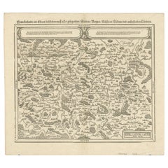
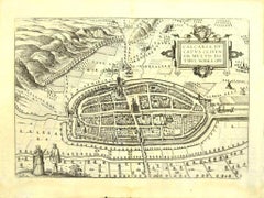
Rare 16th Century Woodcut Map of Brabant and the Rhine Valley, circa 1549
$391.13
£291.19
€330
CA$538.91
A$600.08
CHF 317.34
MX$7,302.62
NOK 4,000.10
SEK 3,768.68
DKK 2,512.13
About the Item
Title: Rare 16th Century Woodcut Map of Brabant and the Rhine Valley, circa 1550
Description:
This rare and highly decorative early woodcut map depicts the region of Brabant and the Rhine Valley, including parts of present-day Netherlands, Belgium, and Germany. Dating from around 1550, the map shows major cities such as Köln (Cologne), Cleve (Kleve), Nimwegen (Nijmegen), Maastricht, Brussel (Brussels), Mechel (Mechelen), Antorff (Antwerp), and Liütich (Liège), alongside rivers like the Maas (Meuse), Scheldt, and Sambre. The title Braband is centrally placed, and the surrounding towns and landscape are presented in a schematic yet charmingly naïve medieval cartographic style.
This map was printed in black ink from a woodblock on laid paper and retains its strong impression and typical 16th-century Gothic script. Such maps were often included in early cosmographies, chronicles, or biblical histories published in Germany or the Low Countries, reflecting the transition from medieval mappa mundi traditions to Renaissance cartography. The depiction combines geographic information with artistic interpretation, featuring stylised buildings, mountains labeled Eifel, and forests, giving a vivid glimpse into early modern European worldviews.
Its historical significance lies in its documentary value of place names, settlement hierarchies, and territorial understanding in the mid-16th century. Collectors prize these woodcut maps for their rarity, graphic strength, and their bridging role between medieval and Ortelian cartography.
Historical note:
This woodcut map originates from the mid-16th century, a transformative era in European cartography. Before the widespread influence of Gerard Mercator and Abraham Ortelius in the later 1500s, maps like this one were produced using woodblock printing and displayed a schematic view of regions rather than precise scaled cartography. They often appeared in cosmographies or chronicles, such as the 'Schedel’s Nuremberg Chronicle' (1493) or Sebastian Münster’s 'Cosmographia' (first published in 1544), intended to educate readers about the known world by combining geography, history, and theology.
Maps of this style were not made for navigation but for illustrating the relative positions of cities, rivers, and regions important for political, ecclesiastical, and trade reasons. The prominent placement of cities like Köln (Cologne), Brussels, and Antwerp reflects their significance as major centres of commerce and governance in the Holy Roman Empire and the Low Countries.
The title Brabant (Braband) refers to the Duchy of Brabant, a key region of the Habsburg Netherlands and later the Spanish Netherlands, covering parts of modern-day Belgium and the southern Netherlands. The map’s inclusion of surrounding areas such as Cleve, Liège, Aachen, and the Eifel mountains situates Brabant within its broader Rhineland and Meuse basin context.
Because many such woodcut maps were discarded or damaged over centuries of use, surviving examples are rare and valued for their graphic simplicity, documentary insights, and connection to pre-Renaissance and early Renaissance worldviews. They are prized by collectors of early European cartography, emblem books, and historical woodcuts for their unique aesthetic and cultural significance.
Condition report:
The map is in good condition for its age, with even age toning and strong ink contrast. There are light handling creases and minor margin wear, with no tears affecting the image area. Some text from verso is faintly visible due to thin paper, typical for woodcut prints of this period.
Framing tips:
This map would display beautifully in a black or dark walnut frame with a warm cream or antique white mat to enhance its historic and graphic qualities. A simple and shallow box frame will protect the delicate paper while presenting it elegantly in a library, study, or as part of a cartographic collection display.
- Dimensions:Height: 4.69 in (11.9 cm)Width: 6.38 in (16.2 cm)Depth: 0.01 in (0.2 mm)
- Materials and Techniques:Paper,Engraved
- Place of Origin:
- Period:
- Date of Manufacture:circa 1549
- Condition:Good condition for its age, with even age toning and strong ink contrast. There are light handling creases and minor margin wear, with no tears affecting the image area. Some text from verso is faintly visible due to thin paper, typical for woodcuts.
- Seller Location:Langweer, NL
- Reference Number:Seller: BG-14072-21stDibs: LU3054345633702
About the Seller
5.0
Recognized Seller
These prestigious sellers are industry leaders and represent the highest echelon for item quality and design.
Platinum Seller
Premium sellers with a 4.7+ rating and 24-hour response times
Established in 2009
1stDibs seller since 2017
2,567 sales on 1stDibs
Typical response time: <1 hour
- ShippingRetrieving quote...Shipping from: Langweer, Netherlands
- Return Policy
Authenticity Guarantee
In the unlikely event there’s an issue with an item’s authenticity, contact us within 1 year for a full refund. DetailsMoney-Back Guarantee
If your item is not as described, is damaged in transit, or does not arrive, contact us within 7 days for a full refund. Details24-Hour Cancellation
You have a 24-hour grace period in which to reconsider your purchase, with no questions asked.Vetted Professional Sellers
Our world-class sellers must adhere to strict standards for service and quality, maintaining the integrity of our listings.Price-Match Guarantee
If you find that a seller listed the same item for a lower price elsewhere, we’ll match it.Trusted Global Delivery
Our best-in-class carrier network provides specialized shipping options worldwide, including custom delivery.More From This Seller
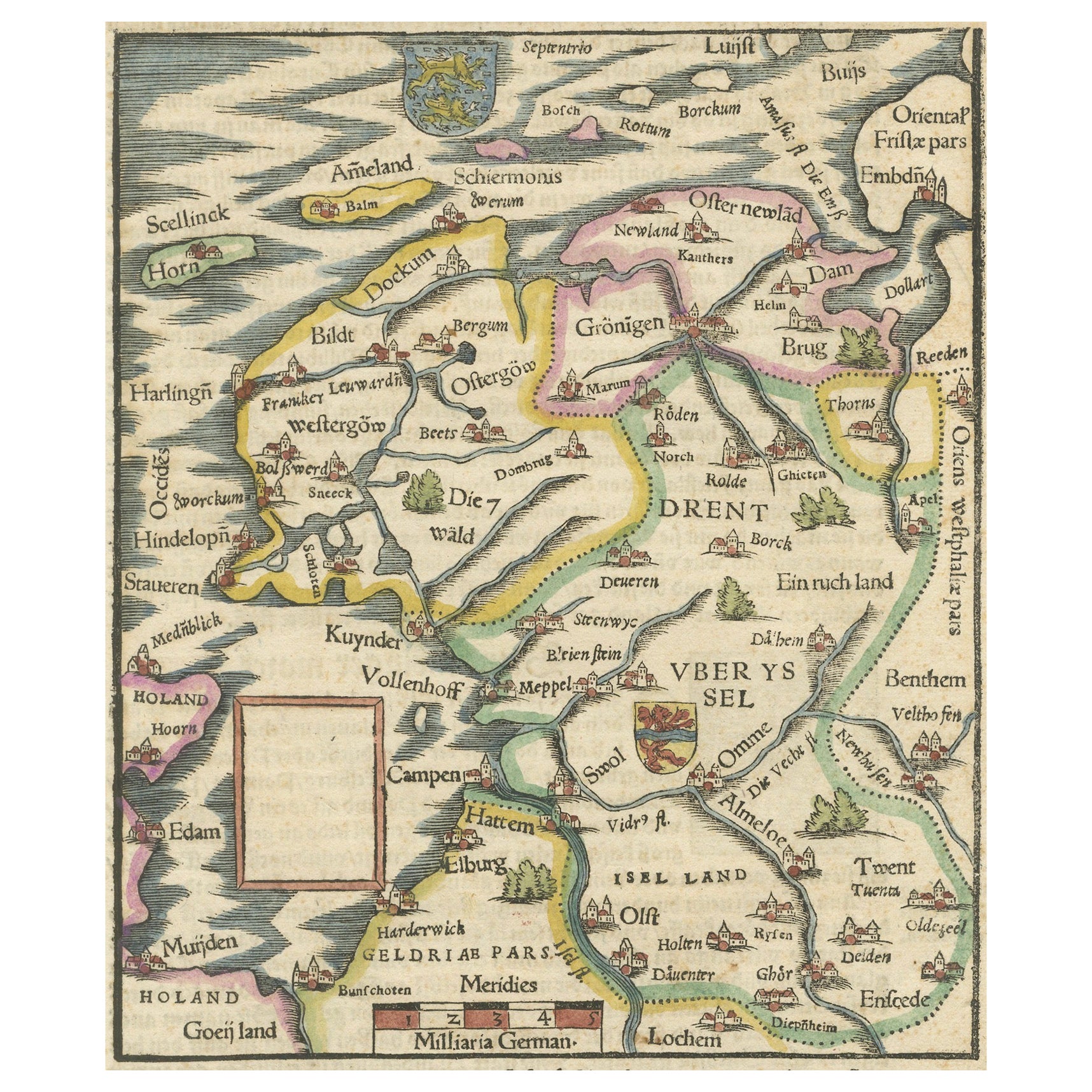
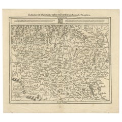
View AllFriesland, Groningen and Overijssel – Rare Woodcut Map by Münster, c. 1550
Located in Langweer, NL
Frisia, Groningen and Overijssel – Rare Woodcut Map by Münster, c. 1550, Germany
This highly decorative 16th-century woodcut map titled “Von dem Teutschen Land: Seelentfrie” was pub...
Category
Antique 16th Century Maps
Materials
Paper
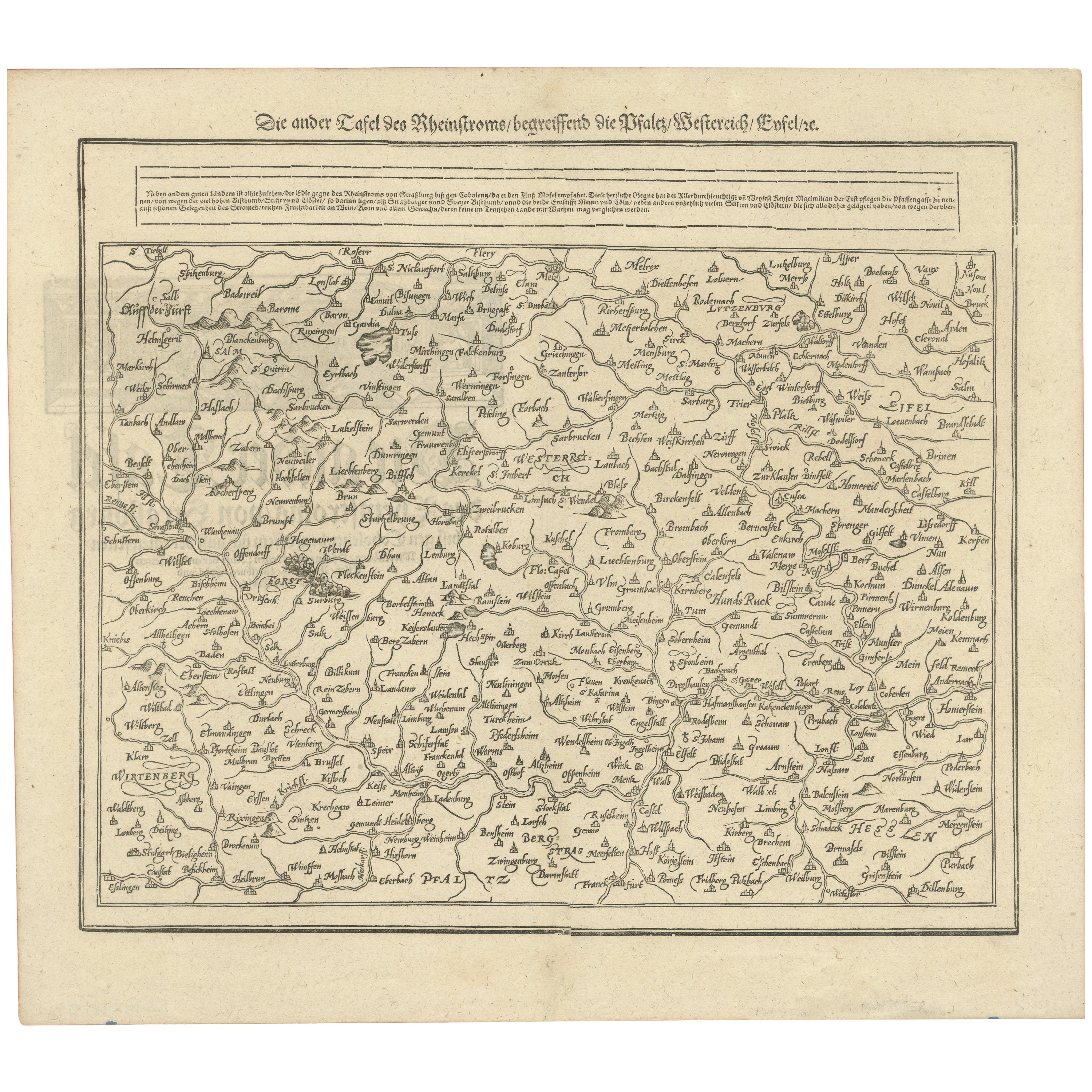
Woodcut Map of the Rhine River Region Covering the Palatinate, Austria and Elsa
Located in Langweer, NL
Early Woodcut Map of the Rhine River Region Covering the Palatinate, Austria, and Elsass, ca. 1628
This early woodcut map, titled "Die ander Tafel des Rheinstromes/begriffen die Pfa...
Category
Antique 1620s Maps
Materials
Paper
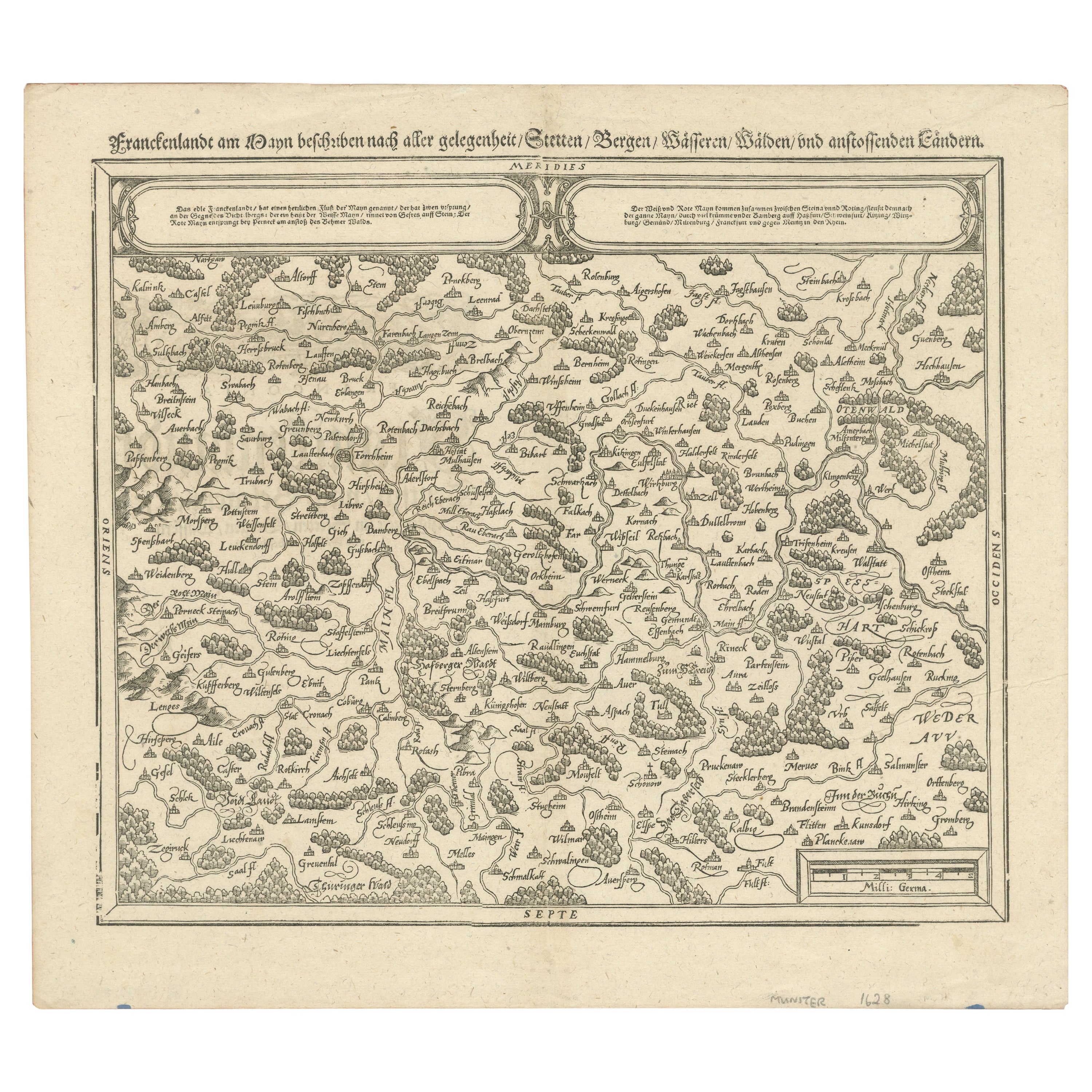
Early Woodcut Map of Franconia and Surrounding Regions, 1628
Located in Langweer, NL
Title: Early Woodcut Map of Franconia and Surrounding Regions, 1628
Franconia (Franckenlande) is a region in Germany. Historically, Franconia was a significant part of the Holy Roma...
Category
Antique 1620s Maps
Materials
Paper
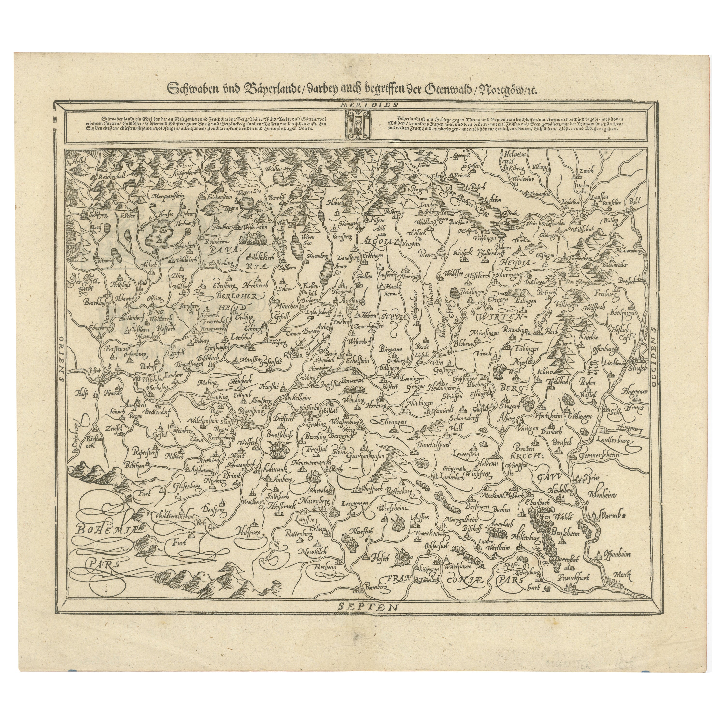
Early Woodcut Map of Swabia and Bavaria in Germany, 1628
Located in Langweer, NL
Title: Early Woodcut Map of Swabia and Bavaria, 16th Century
This early woodcut map titled "Schwaben und Bayernlande / Darbey auch begreiffen der Oenwaldt / Nordgaw / etc." provides...
Category
Antique 1620s Maps
Materials
Paper
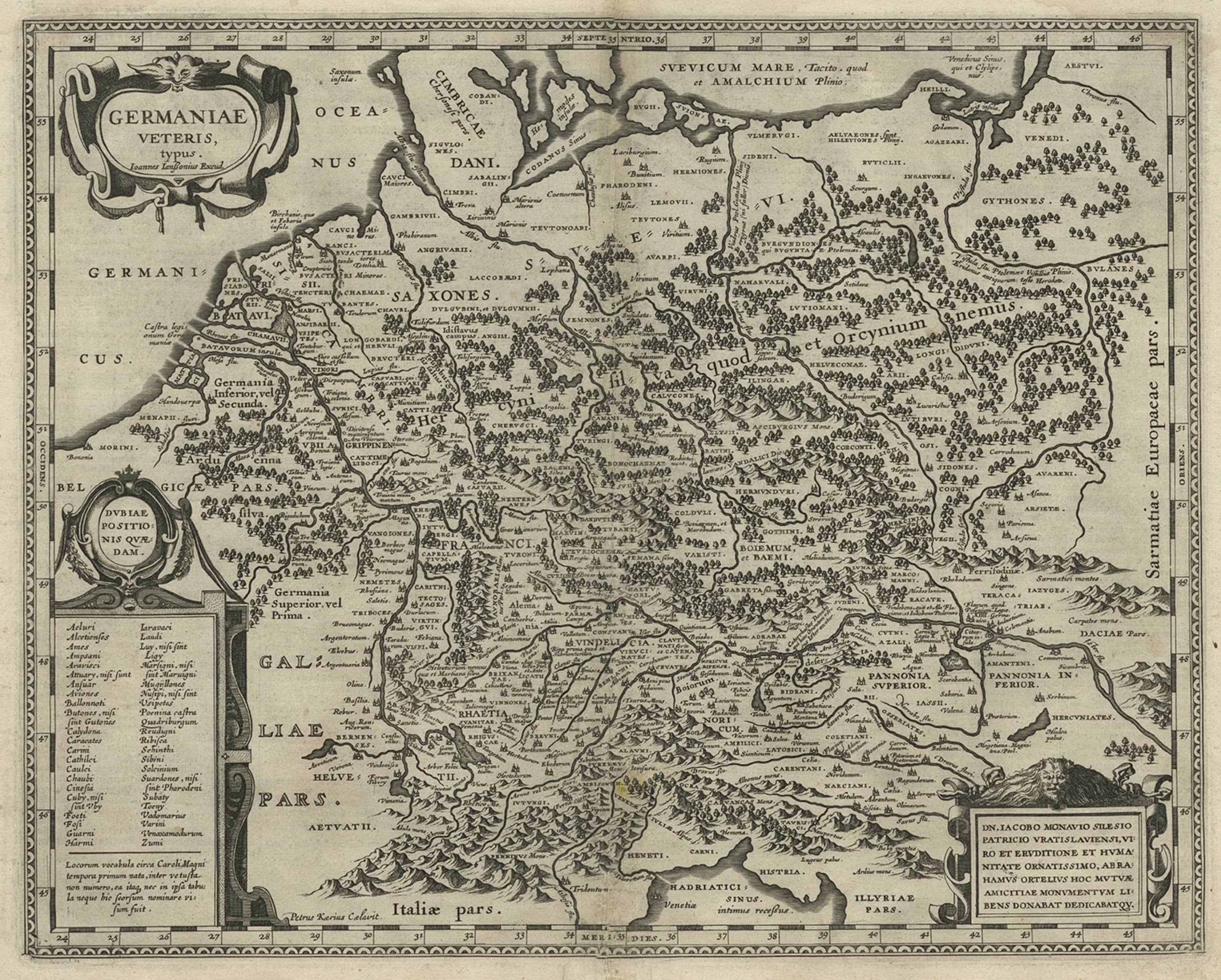
Original Rare Antique Map of the Ancient German Empire in Northern Europe, c1650
Located in Langweer, NL
Antique map titled 'Germaniae Veteris typus.'
Map of the ancient German Empire in Northern Europe, based upon an earlier map by Ortelius. Extends fr...
Category
Antique 1650s Maps
Materials
Paper
$625 Sale Price
20% Off
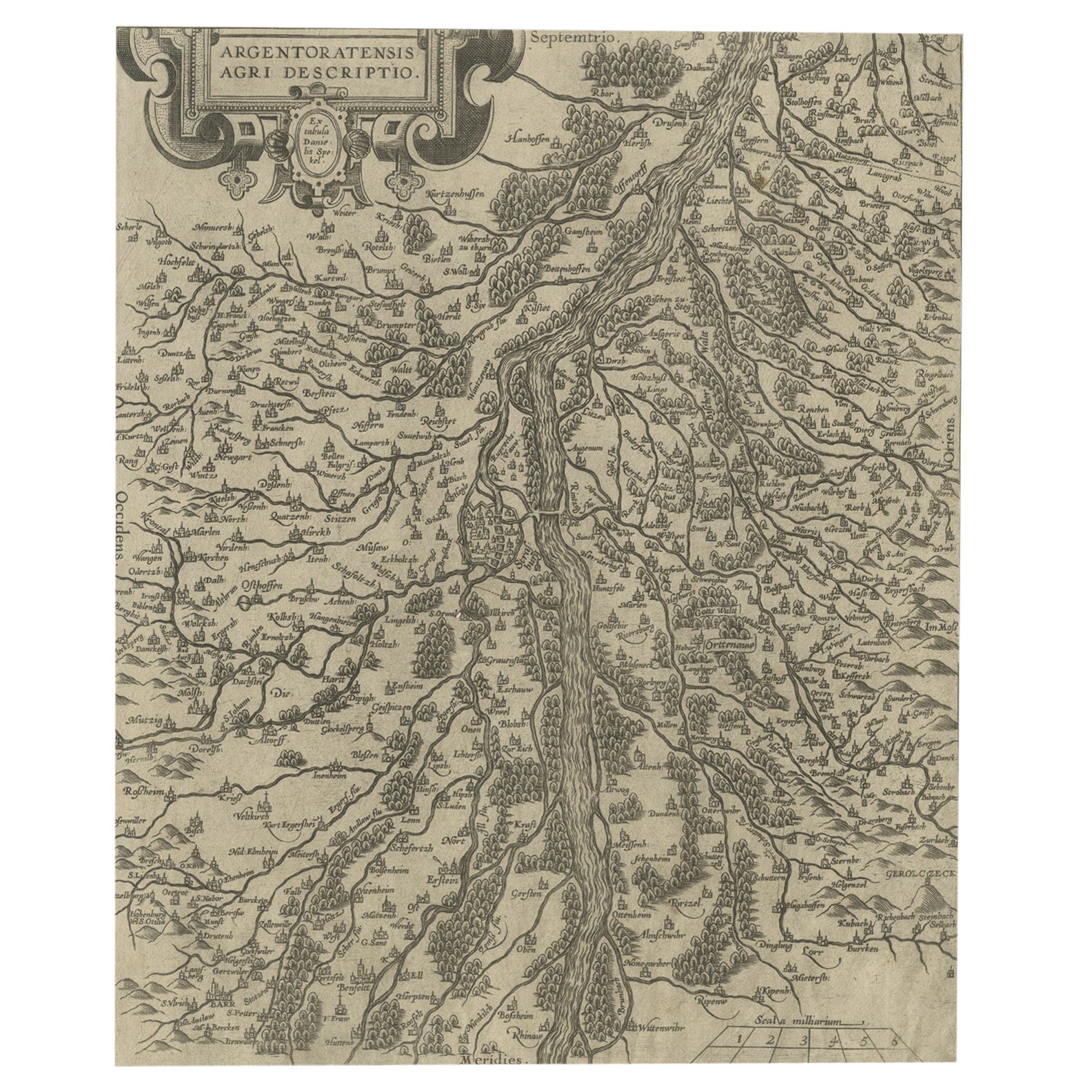
Original Antique Map of the Rhine, South and North of Strasbourg, Germany, 1608
Located in Langweer, NL
Antique map titled 'Argentoratensis agri descriptio'.
Original antique map of the Rhine, both south and north of Strasbourg, based on Daniel Specklin's three-sheet map of the Elz...
Category
Antique Early 1600s Maps
Materials
Paper
$303 Sale Price
20% Off
You May Also Like
Map of the Netherlands - Etching by G. Braun and F. Hogenberg -Late 16th Century
By Franz Hogenberg
Located in Roma, IT
Map of the Netherlands is an original etching realized by George Braun and Franz Hogenberg, as part of the "Civitates Orbis Terrarum".
The “Civitates Orbis Terrarum” (Atlas of Citi...
Category
16th Century Figurative Prints
Materials
Etching

Map of Kalkar - Etching by G. Braun and F. Hogenberg - Late 16th Century
By Franz Hogenberg
Located in Roma, IT
This map of Calcaria is an original etching realized by George Braun and Franz Hogenberg, as part of the famous Series "Civitates Orbis Terrarum" (Atlas of the Cities of the World)....
Category
16th Century Figurative Prints
Materials
Etching
Map of San Georgi - Etching by G. Braun/F. Hogenberg - 1575
Located in Roma, IT
Etching by Georg Braun and Frans Hogenberg, realized in 1575 and belonging to the Suite "Civitates Orbis Terrarum".
The first volume of the Civitates Orbis Terrarum was published in ...
Category
16th Century Modern Figurative Prints
Materials
Etching
Luneburg, Map from "Civitates Orbis Terrarum" - by F.Hogenberg - 1575
By Franz Hogenberg
Located in Roma, IT
"Luneburg", from the collection "Civitates Orbis Terrarum", Cologne, T. Graminaeus, 1575.
The “Civitates Orbis Terrarum” (Atlas of Cities of the World) was the second oldest print...
Category
16th Century Figurative Prints
Materials
Etching, Aquatint
Buda, Antique Map from "Civitates Orbis Terrarum" - 1572-1617
By Franz Hogenberg
Located in Roma, IT
Braun G., Hogenberg F., Buda, from the collection Civitates Orbis Terrarum, Cologne, T. Graminaeus, 1572-1617.
Very fine B/W aquatint showing a view of Buda, an actual part of Budap...
Category
16th Century Landscape Prints
Materials
Etching
16th c. woodcut map - Tabula Asiae Vlll
By Sebastian Münster
Located in Santa Monica, CA
SEBASTIAN MUNSTER (1488-1652)
ASIAE TABVLA Vlll 1540 (45)
Woodcut from Munster's edition of Geographia Universalis, Basel, Henri Petri. 1545 edit...
Category
16th Century Old Masters Landscape Prints
Materials
Woodcut

$950 Sale Price
29% Off
More Ways To Browse
Antique Script
Gothic German
Gothic Library
Antique Walnut Gothic Furniture
Southern Gothic
Nuremberg Box
Styles Of Antique Desks
Black And White Coffee Table
Curved Velvet Couch
Velvet Curved Sofa
Wood Round Coffee Tables
Antique Paper Flowers
Oak Brutalist
Used College Furniture
Wood Minimalist Chair
2002 Lamp
Antique Imperial Furniture
Gold Modern Coffee Table