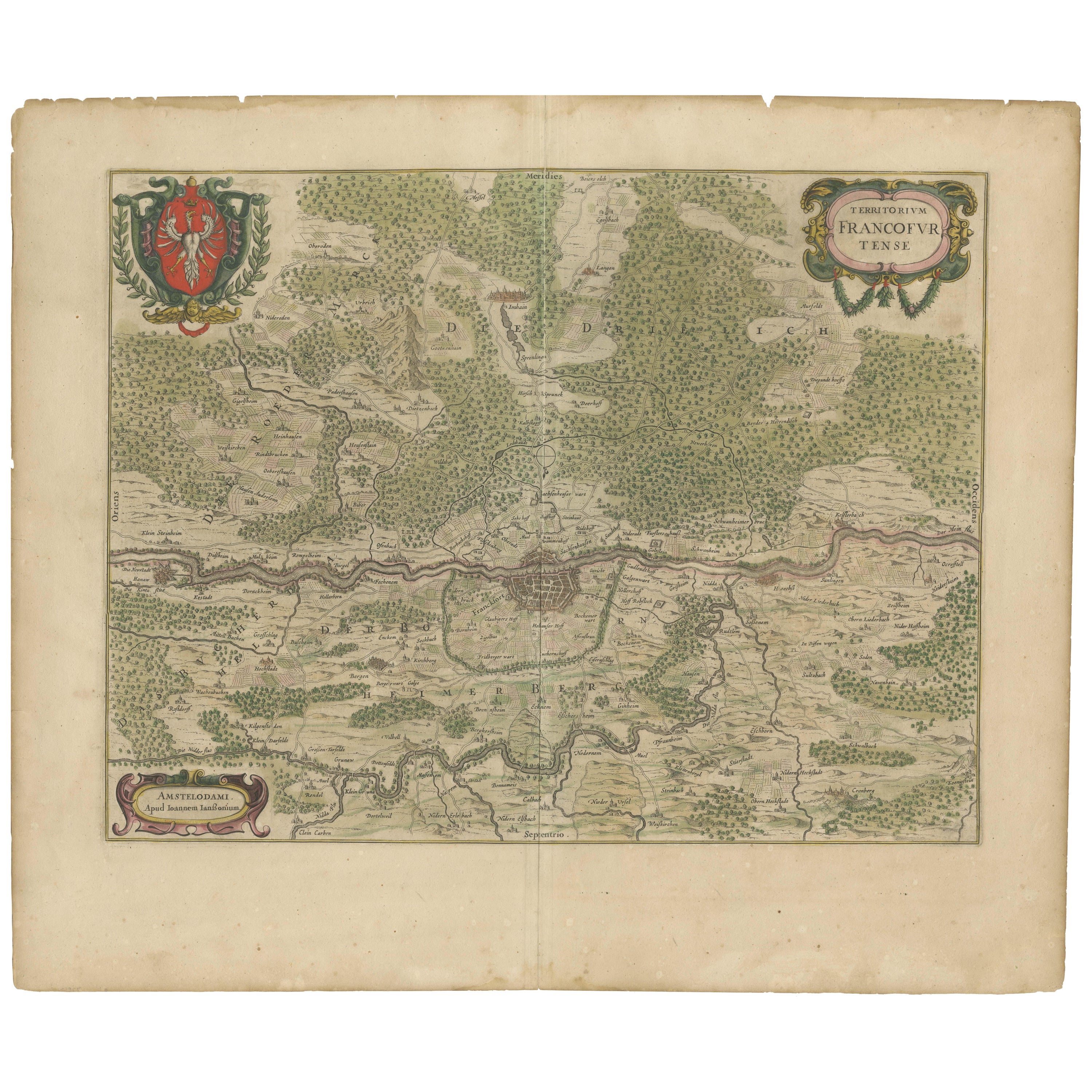
Items Similar to Territorium Francofurtens – Moses Pitt’s 17th-Century Map of Frankfurt


Want more images or videos?
Request additional images or videos from the seller
1 of 7
Territorium Francofurtens – Moses Pitt’s 17th-Century Map of Frankfurt
$2,275.05
£1,681.77
€1,900
CA$3,094.23
A$3,467.07
CHF 1,804.74
MX$42,414.25
NOK 22,907.85
SEK 21,636.19
DKK 14,467.57
Shipping
Retrieving quote...The 1stDibs Promise:
Authenticity Guarantee,
Money-Back Guarantee,
24-Hour Cancellation
About the Item
Title: Territorium Francofurtens – Moses Pitt’s 17th-Century Map of Frankfurt
Description:
This rare 17th-century map, titled Territorium Francofurtens, was published by Moses Pitt, a notable English mapmaker and publisher active in the late 1600s. Dedicated to John Hillersdon of the Inner Temple Esq., the map presents a finely detailed representation of Frankfurt and its surrounding region along the Main Rive*, including Offenbach, Hanau, and numerous villages, forests, and topographical features.
John Hillersdon of the Inner Temple, Esq., was an English legal professional associated with the Inner Temple, one of the four Inns of Court in London responsible for training barristers. While specific details about his life and career are limited, the Hillersdon family had notable connections to the legal profession during the 17th century. For instance, Thomas Hillersdon V, born in 1653, matriculated at Christ Church, Oxford, and entered the Inner Temple as a student in 1670. It's possible that John Hillersdon was a relative, perhaps a brother or cousin, who also pursued a legal career. Further research into historical records or genealogical sources may provide more detailed information about his background and contributions.
The map exhibits intricate engraving work, showcasing the dense urban fabric of Frankfurt at its center, along with roads, rivers, fields, and wooded areas. The elaborate title cartouche and ornamental coat of arms add to its decorative appeal, making it not only a geographical document but also an artistic piece.
Moses Pitt is best known for his ambitious, though financially troubled, *Atlas Major*, intended to rival Blaeu and Janssonius' works. This map, created in that period, reflects his high standards in cartographic craftsmanship.
More about Moses Pitt:
Moses Pitt (c. 1639–1697) was an English bookseller and printer renowned for his ambitious project, The English Atlas. Born in St Teath, Cornwall, Pitt began his publishing career in London in 1667, focusing on scholarly works and collaborating with prominent figures like Robert Boyle and Gilbert Burnet. In 1678, he embarked on creating a comprehensive twelve-volume world atlas, aiming to rival the works of Dutch cartographers Blaeu and Janssonius. Despite support from the Royal Society and individuals such as Christopher Wren, only four volumes were completed between 1680 and 1683 due to escalating costs, estimated by Pitt at £1,000 per volume. This financial strain led to his bankruptcy and imprisonment for seven years in debtor's prison. During his incarceration, Pitt authored 'The Cry of the Oppressed' (1691), highlighting the harsh conditions faced by imprisoned debtors in England.
Moses Pitt collaborated with Stephan Swart (also spelled Swaert) and Jan Jansson van Waesbergen in the late 17th century. Together, they aimed to produce a comprehensive twelve-volume work titled The English Atlas, intended to rival the atlases of Blaeu and Janssonius. Between 1680 and 1683, they successfully published four volumes, but escalating costs led to the project's premature cessation. This ambitious endeavor ultimately contributed to Pitt's financial downfall and subsequent imprisonment for debt.
An example of their collaboration is the English edition of Jansson's map of southern Moscovia, titled "Moscoviæ Pars Australis," published around 1680. This map credits Jan Jansson van Waesbergen, Moses Pitt, and Stephan Swart as publishers.
Therefore, Moses Pitt did work closely with Stephan Swart and Jan Jansson van Waesbergen on significant cartographic projects during that period.
Condition Report:
Paper Quality: 17th-century laid paper with even age toning.
Engraving: Sharp and well-preserved with excellent detail.
Margins: Wide margins with only minor signs of aging.
Overall Condition: Excellent for its age, with no significant damage.
Framing Tips:
Matting: Use an acid-free cream or light tan mat to complement the aged paper.
Glass: UV-resistant museum glass will protect against light exposure.
Frame Style: A classic dark wood or gilt frame enhances the historic aesthetic.
Mounting: Archival mounting to preserve the integrity of the engraving.
A rare and historically significant map, this piece is a fine addition to any collection of 17th-century European cartography.
- Dimensions:Height: 20.67 in (52.5 cm)Width: 26.66 in (67.7 cm)Depth: 0.01 in (0.2 mm)
- Materials and Techniques:Paper,Engraved
- Period:1690-1699
- Date of Manufacture:circa 1690
- Condition:Overall Condition: Very good for its age, with no significant damage, except for one small hole touching the lower platemark. No text on reverse. Folding line as issued.
- Seller Location:Langweer, NL
- Reference Number:Seller: BG-13671-21stDibs: LU3054343838942
About the Seller
5.0
Recognized Seller
These prestigious sellers are industry leaders and represent the highest echelon for item quality and design.
Platinum Seller
Premium sellers with a 4.7+ rating and 24-hour response times
Established in 2009
1stDibs seller since 2017
2,493 sales on 1stDibs
Typical response time: <1 hour
- ShippingRetrieving quote...Shipping from: Langweer, Netherlands
- Return Policy
Authenticity Guarantee
In the unlikely event there’s an issue with an item’s authenticity, contact us within 1 year for a full refund. DetailsMoney-Back Guarantee
If your item is not as described, is damaged in transit, or does not arrive, contact us within 7 days for a full refund. Details24-Hour Cancellation
You have a 24-hour grace period in which to reconsider your purchase, with no questions asked.Vetted Professional Sellers
Our world-class sellers must adhere to strict standards for service and quality, maintaining the integrity of our listings.Price-Match Guarantee
If you find that a seller listed the same item for a lower price elsewhere, we’ll match it.Trusted Global Delivery
Our best-in-class carrier network provides specialized shipping options worldwide, including custom delivery.More From This Seller
View AllAntique Map of Germany of German in Roman Times, c.1660
Located in Langweer, NL
Antique map Germany titled 'Germaniae Veteris Typus'. Antique map probably by Blaeu or based on an earlier state by W. Blaeu.
Minor differences shown in the cartouches. Top left ha...
Category
Antique 17th Century Maps
Materials
Paper

$814 Sale Price
20% Off
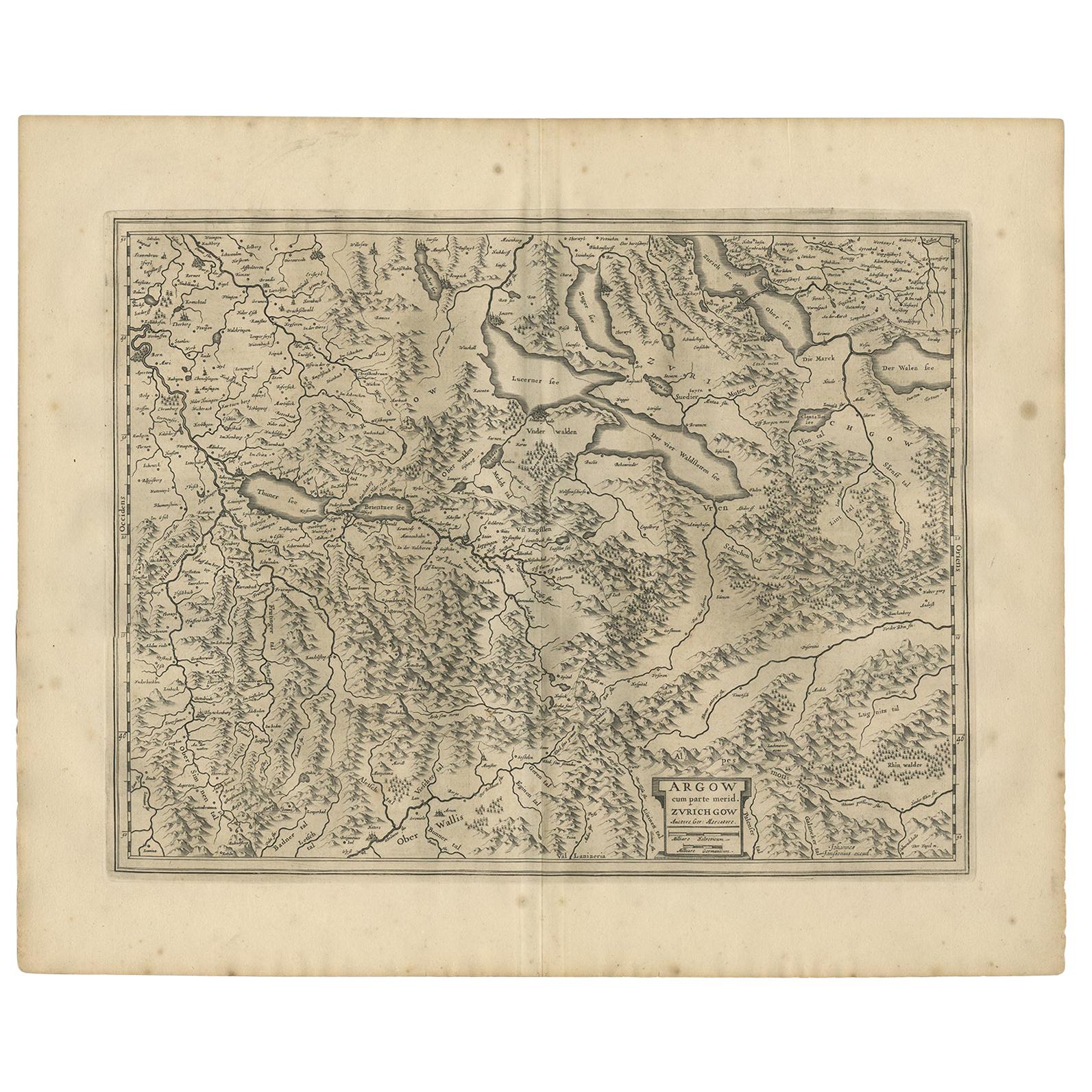
Antique Map of the Region of Aargau by Janssonius, '1657'
By Johannes Janssonius
Located in Langweer, NL
Antique map 'Argow cum parte merid. Zurichgow'. Detailed map of Switzerland showing Aargau with the southern part of Zürich. This map originates from 'Atlas Novus, Sive Theatrum Orbi...
Category
Antique Mid-17th Century Maps
Materials
Paper
$574 Sale Price
20% Off
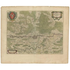
Antique Map of the Frankfurt Region by Johannes Janssonius, Hand-Colored, C.1650
Located in Langweer, NL
Antique Map of the Frankfurt Region by Johannes Janssonius circa 1650 Hand-Colored
This rare and beautifully detailed antique map titled Territorium Francofurtense depicts the reg...
Category
Antique 1650s Maps
Materials
Paper
Antique Map of Southern Germany by F. de Wit, circa 1680
Located in Langweer, NL
This antique map depicts a portion of southern Germany that included the historic regions of Bavaria, the Palatinate, Prussia-Brandenburg, the Rhineland and Saxony. Regensberg, Freis...
Category
Antique Late 17th Century Maps
Materials
Paper

$665 Sale Price
20% Off
Old Map of the Western Part of Central Europe, c.1680
Located in Langweer, NL
Antique map titled 'Carta nova accurate del Passagio et strada dalli Paesi Bassi'. Old map of the western portion of Central Europe. Oriented to the Northeast.
Artists and Engrav...
Category
Antique 17th Century Maps
Materials
Paper

$359 Sale Price
20% Off
Antique Map of Austria by N. Visscher, circa 1690
Located in Langweer, NL
Antique map titled 'Austriae Archiducatus pars superior in omnes ejusdem'. Spectacular large map of Upper and Lower Austria between Passau and Wien with figurative cartouche and armo...
Category
Antique Late 17th Century Maps
Materials
Paper

$890 Sale Price
20% Off
You May Also Like
1657 Janssonius Map of Vermandois and Cappelle, Ric. A-004
Located in Norton, MA
1657 Janssonius map of
Vermandois and Cappelle
Ric.a004
Description: Antique map of France titled 'Descriptio Veromanduorum - Gouvernement de la Cappelle'. Two detailed maps o...
Category
Antique 17th Century Unknown Maps
Materials
Paper

18th Century Hand-Colored Homann Map of Germany, Including Frankfurt and Berlin
By Johann Baptist Homann
Located in Alamo, CA
An 18th century hand-colored map entitled "Tabula Marchionatus Brandenburgici et Ducatus Pomeraniae quae sunt Pars Septentrionalis Circuli Saxoniae Superioris" by Johann Baptist Homa...
Category
Antique Early 18th Century German Maps
Materials
Paper

17th Century Hand-Colored Map of a Region in West Germany by Janssonius
By Johannes Janssonius
Located in Alamo, CA
This attractive highly detailed 17th century original hand-colored map is entitled "Archiepiscopatus Maghdeburgensis et Anhaltinus Ducatus cum terris adjacentibus". It was published ...
Category
Antique Mid-17th Century Dutch Maps
Materials
Paper

Prussia, Poland, N. Germany, Etc: A Hand-colored 17th Century Map by Janssonius
By Johannes Janssonius
Located in Alamo, CA
This is an attractive hand-colored copperplate engraved 17th century map of Prussia entitled "Prussia Accurate Descripta a Gasparo Henneberg Erlichensi", published in Amsterdam by Joannes Janssonius in 1664. This very detailed map from the golden age of Dutch cartography includes present-day Poland, Latvia, Lithuania, Estonia and portions of Germany. This highly detailed map is embellished by three ornate pink, red, mint green and gold...
Category
Antique Mid-17th Century Dutch Maps
Materials
Paper

1656 Jansson Map Metz Region of France Entitled "Territorium Metense" Ric0014
Located in Norton, MA
1656 Jansson map Metz Region of France entitled "Territorium Metense."
Ric0014
" Authentic" - Map of the historical region surrounding Metz, in Lorraine, France.
Oriented with ...
Category
Antique 17th Century Dutch Maps
Materials
Paper

Vienna, Austria: A Large 17th Century Hand-Colored Map by Sanson and Jaillot
By Nicolas Sanson
Located in Alamo, CA
This large 17th century hand-colored map of Vienna, Austria and the surrounding countryside and villages entitled "Plan de la Ville de Vienne en Austrich...
Category
Antique 1690s French Maps
Materials
Paper

More Ways To Browse
Thomas Toner
Gilt Coat Of Arms
17th Century Dutch Wood Frames
Jans Of London
Antique Furniture Cornwall
Imprisoned Glass
Used Office Furniture Cornwall
Prison Sign
Silver Metal Chair
Swedish Kilim
Vintage Scandanavian Chairs
Vintage Tropical Furniture
19th Century Red Glass
Antique French Console Table Tables
French 50s
Silver Bowl Large
Antique French Silk
Down Couch