Items Similar to Tony Sarg Map of Nantucket Town, 1937
Want more images or videos?
Request additional images or videos from the seller
1 of 7
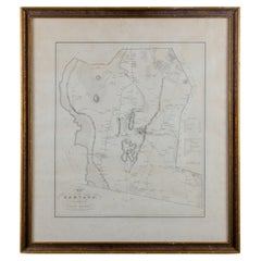
Tony Sarg Map of Nantucket Town, 1937
$1,200
£907.05
€1,042.36
CA$1,670.99
A$1,858.91
CHF 974.46
MX$22,715.44
NOK 12,408.59
SEK 11,680.97
DKK 7,780.85
Shipping
Retrieving quote...The 1stDibs Promise:
Authenticity Guarantee,
Money-Back Guarantee,
24-Hour Cancellation
About the Item
Tony Sarg Map of Residential Main Street, Nantucket, 1937, a black and white printed map of our historic downtown area, with images of each building, street names and whimsical figures, and an insert in the upper left giving details of many of the historic houses; flanked by two columns of iconic island figures and landmarks; signed and dated in the print lower right.
The map remains in excellent condition, and has been recently mounted in conservation matting and an ebonized frame.
Measures: 18-3/4 in H x 16-5/8
Framed: 24-1/4 in H x 22-1/8 in W
- Creator:Tony Sarg (Designer)
- Dimensions:Height: 24.25 in (61.6 cm)Width: 22.13 in (56.22 cm)Depth: 0.75 in (1.91 cm)
- Style:Other (Of the Period)
- Materials and Techniques:Paper,Other
- Place of Origin:
- Period:
- Date of Manufacture:1937
- Condition:Wear consistent with age and use.
- Seller Location:Nantucket, MA
- Reference Number:Seller: AD - BO-171stDibs: LU903942119612
About the Seller
5.0
Gold Seller
Premium sellers maintaining a 4.3+ rating and 24-hour response times
1stDibs seller since 2010
271 sales on 1stDibs
Typical response time: 1 hour
- ShippingRetrieving quote...Shipping from: Nantucket, MA
- Return Policy
Authenticity Guarantee
In the unlikely event there’s an issue with an item’s authenticity, contact us within 1 year for a full refund. DetailsMoney-Back Guarantee
If your item is not as described, is damaged in transit, or does not arrive, contact us within 7 days for a full refund. Details24-Hour Cancellation
You have a 24-hour grace period in which to reconsider your purchase, with no questions asked.Vetted Professional Sellers
Our world-class sellers must adhere to strict standards for service and quality, maintaining the integrity of our listings.Price-Match Guarantee
If you find that a seller listed the same item for a lower price elsewhere, we’ll match it.Trusted Global Delivery
Our best-in-class carrier network provides specialized shipping options worldwide, including custom delivery.More From This Seller
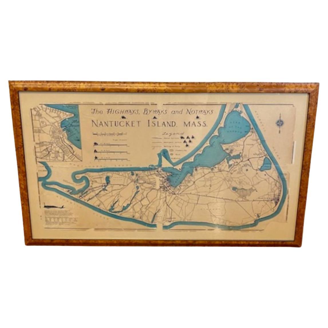
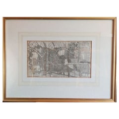
View AllNantucket High-Ways, By-Ways and Not-Ways Decorative Map by Tony Sarg, ca 1930
By Tony Sarg
Located in Nantucket, MA
Vintage Nantucket High-Ways, By-Ways and Not-Ways Decorative Map by Tony Sarg, (Nantucket: 1880 - 1942) circa 1930, a decorative tourist map of Nantucket Island with details of roadw...
Category
Vintage 1930s American Other Maps
Materials
Paper

19th Century Chart of New England Coast, 1847
By U.S. Government
Located in Nantucket, MA
19th Century Chart of New England Coast: the U.S. Coast Survey Sketch A - Section 1, a triangulation chart showing the progress of the survey and details along the New England coas...
Category
Antique 1840s American Other Maps
Materials
Paper

Nantucket Watercolor of Old North Wharf, by Doris and Richard Beer, circa 1940
Located in Nantucket, MA
Vintage Nantucket Watercolor of Old North Wharf, by Doris and Richard Beer, circa 1940, a watercolor on paper view of shell lane down center of ol...
Category
Vintage 1940s American Folk Art Paintings
Materials
Paper

Print of Nantucket Daydreams, by Henry S. Wyer, Nantucket, circa 1900
Located in Nantucket, MA
Antique Print of Nantucket Daydreams, by Henry S. Wyer, Nantucket, circa 1900, a period print depicting a gentleman in overstuffed wing chair by the hearth, a copy of Nantucket's "Inquirer and Mirror" open on lap, smoking a cigar and leaning back lost in thought: in the curls of smoke are simple sketches of many iconic Nantucket landmarks and views. Flanking the fireplace in place of tiles are a series of miniature copies of eight of H.S. Wyer's photographs. This is one of the rarest of antique Nantucket prints...
Category
Antique Early 1900s American Late Victorian Prints
Materials
Paper
Large U.S. Coast and Geodetic Survey Chart A of the Atlantic Coast, 1877
Located in Nantucket, MA
Large U.S. Coast and Geodetic Survey Chart A of the Atlantic Coast, 1877, re-issued in February 1881, a printed paper laid down on linen navigational chart of the U.S. Atlantic coast...
Category
Antique 1880s American Other Maps
Materials
Linen

Nantucket Old North Wharf Watercolor by Doris & Richard Beer, circa 1940
By Richard Beer (American), Doris Beer
Located in Nantucket, MA
Vintage Nantucket Old North Wharf Watercolor by Doris & Richard Beer, circa 1940, a watercolor on paper view of Old North Wharf, signed in pencil power right. Doris and Richard Beer (1898-1967 and 1893-1959 respectively) produced a well-known series of watercolor miniatures featuring popular Nantucket scenes. Working at their Wharf Head Studio on Old North Wharf for 18 years, the couple worked together on these copyrighted creations, photo-duplicating Doris's line sketch and Doris and Richard completing the watercolor.
One of a large collection of Beer watercolors...
Category
Mid-20th Century American Other Paintings
Materials
Paper
You May Also Like
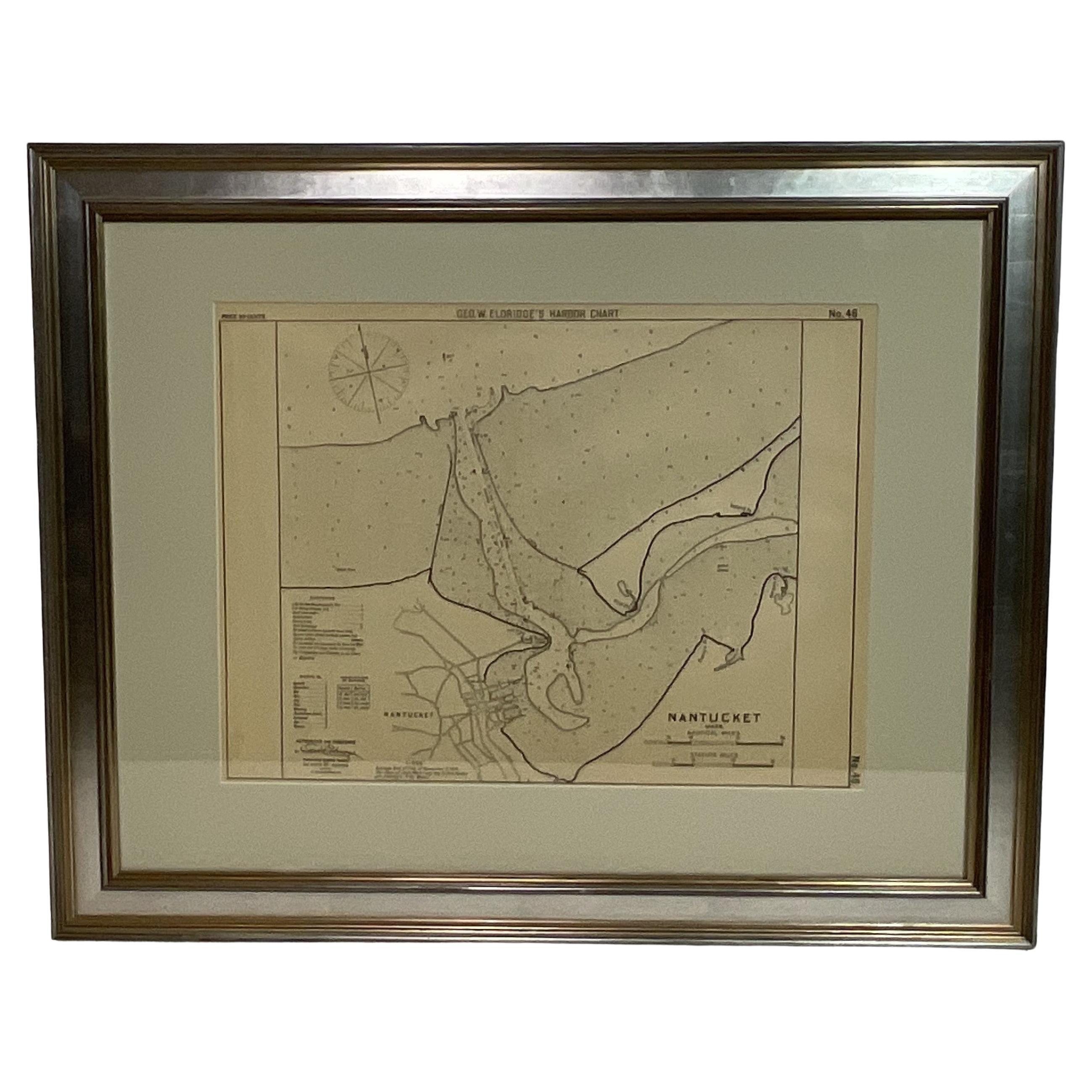
1907 Chart of Nantucket Harbor by George Eldridge
Located in Norwell, MA
Chart of Nantucket Harbor from 1907 by cartographer George W. Eldridge. The chart shows the channel passing by the jetty into the harbor, by Brant Point to Steamboat Wharf. Also show...
Category
Antique Early 1900s North American Maps
Materials
Paper

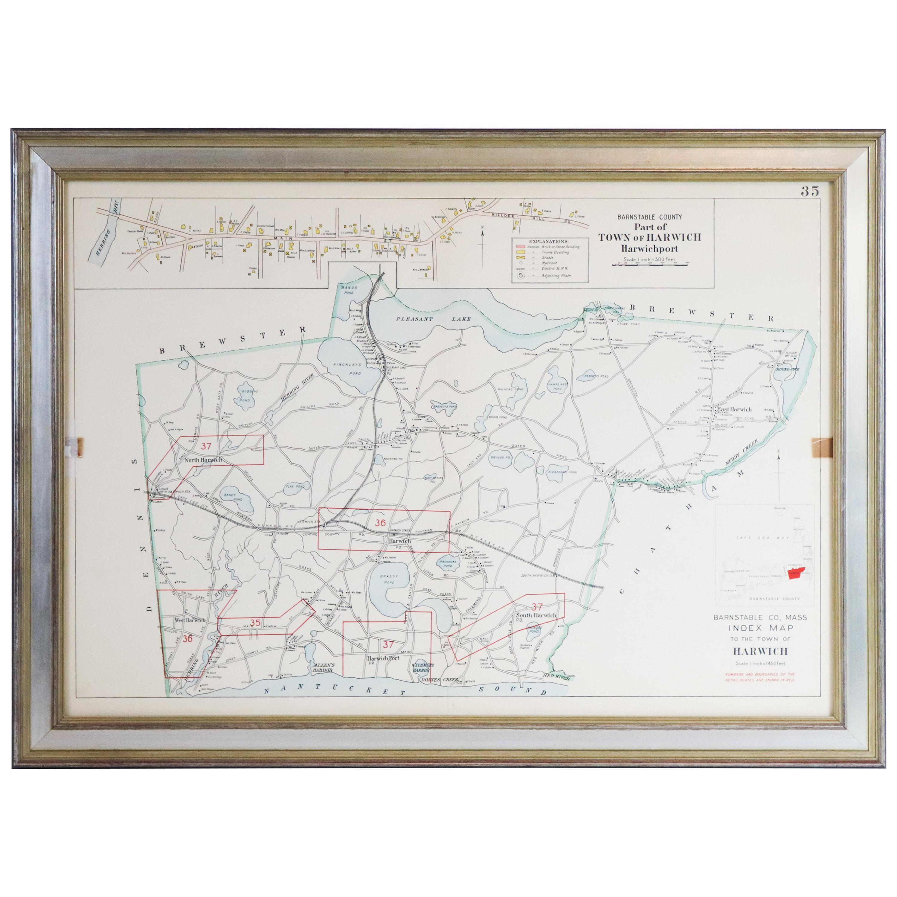
Map of Harwich, Massachusetts
Located in Norwell, MA
Turn of the century map of Harwich, Massachusetts. Plate from a Cape Cod County Map book showing the Barnstable county town of Harwich including Allens Harbor, Pleasant Lake, Harwich...
Category
20th Century Maps

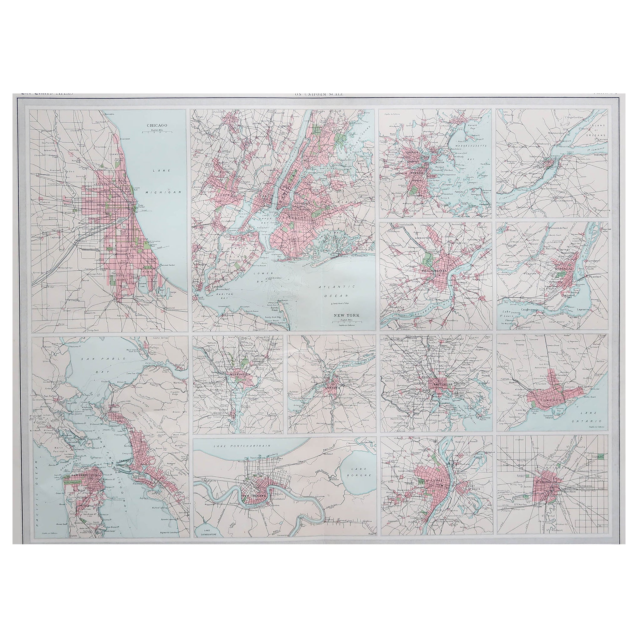
Antique Map of American Cities, Vignette of New York City, circa 1920
Located in St Annes, Lancashire
Great maps of American Cities
Unframed
Original color
By John Bartholomew and Co. Edinburgh Geographical Institute
Published, circa 1920
Category
Vintage 1920s British Maps
Materials
Paper

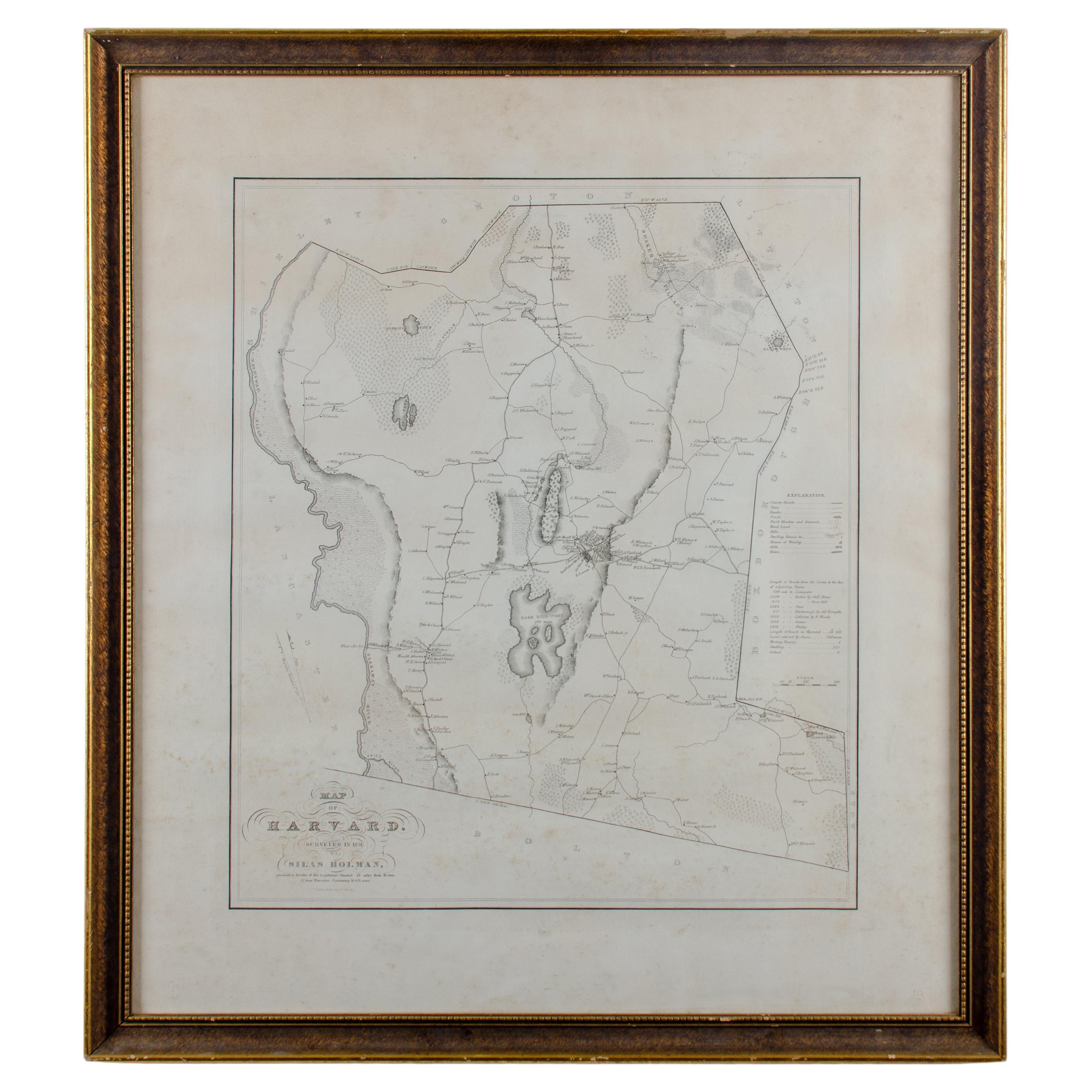
Silas Holman Map of Harvard
Located in Savannah, GA
A framed historic map of Harvard, as surveyed in 1831 by Silas Holman, reproduced circa 1920s.
frame: 29 by 32 inches
Category
Vintage 1920s Other Prints
Materials
Glass, Wood, Paper
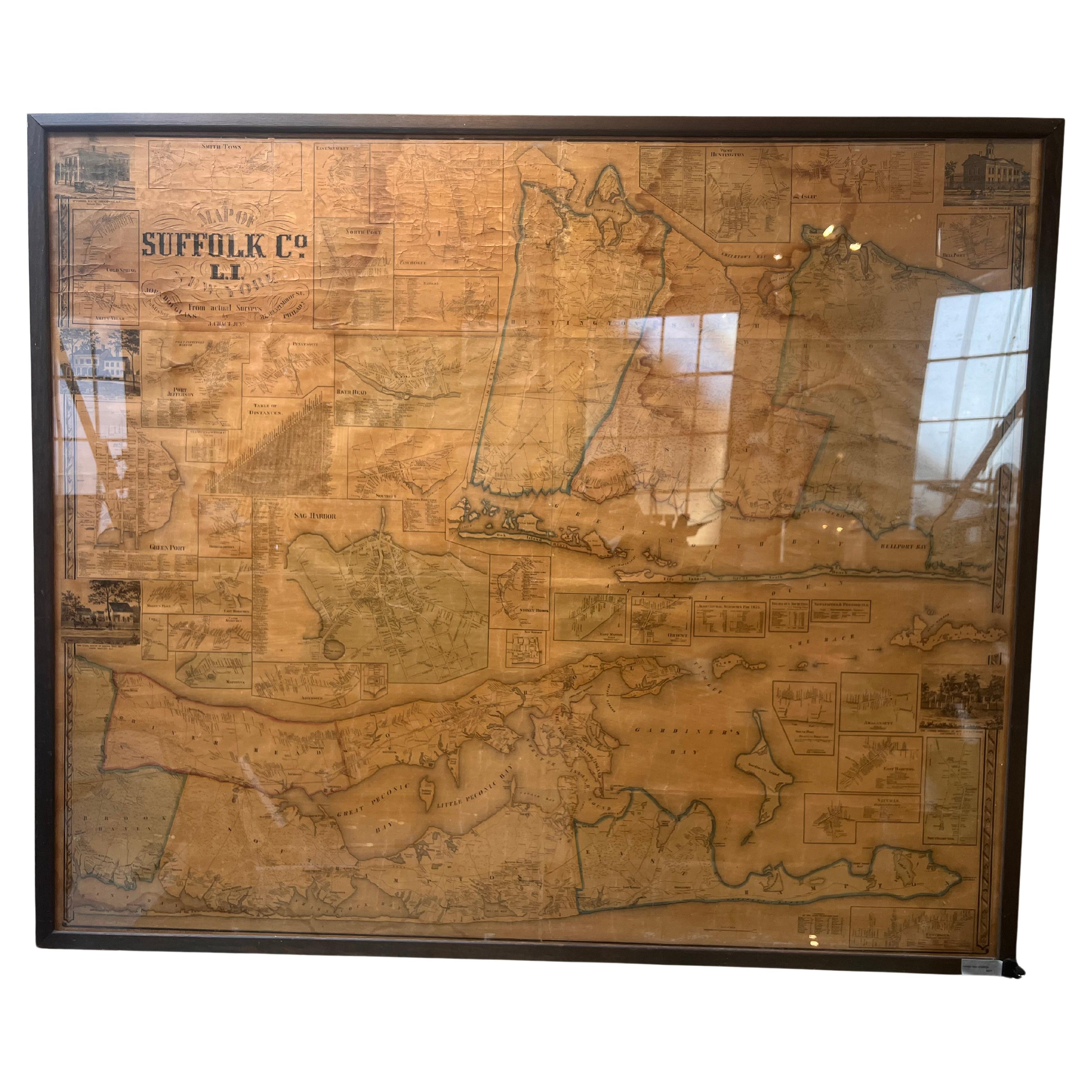
Framed Mid-19th Century Wall Map of Long Island, the Hamptons
Located in Sag Harbor, NY
A Framed museum quality find. This large wall map dates to the mid-1800s. Detailed inset maps of, Sag Harbor, East Hampton, Amagansett, Shelter Island and most villages in Long Island. It also has agriculture stats for 1855. Detailed prints of homes on Scuttle Hole in Bridgehampton as well as several other detailed prints. Lists of businesses, distance tables and railroad schedules and stops. The total amount of detailed information about Suffolk County Long Island is staggering. A unique rare New York map...
Category
Antique Mid-19th Century American Maps
Materials
Linen, Paper

$7,100 Sale Price
20% Off
Antique Map of the City of Haarlem by Tirion, 1742
By Isaak Tirion
Located in Langweer, NL
Antique map titled 'Grondtekening van Haarlem (..)'. Original antique map of the city of Haarlem, the Netherlands. Published by I. Tirion, 1742.
Artists and Engravers: Isaak Tirio...
Category
Antique 18th Century Maps
Materials
Paper
$210 Sale Price
20% Off
More Ways To Browse
The Vintage Map
Nantucket Signs
Coffee Tables Europe
Marble Top Dining Tables
Nordiska Argentina
Pink And Black Rug
Black Wooden Chair
Orrefors Embassy
Black Ebonized
Elios Chair
Panache Designs
Plata Lappas
Red Retro Dining Set
Antique Bouquet
Antique Silver Glasses Case
Carlo Scarpa 1934 Chairs
Christofle Marly
1900 Antique Chairs