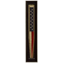
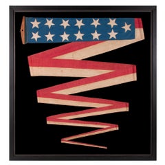
Antique 13-Star United States Naval Commissioning Pennant
View Similar Items


Want more images or videos?
Request additional images or videos from the seller
1 of 5
Antique 13-Star United States Naval Commissioning Pennant
$4,200List Price
About the Item
- Dimensions:Height: 59 in (149.86 cm)Width: 11 in (27.94 cm)Depth: 2.5 in (6.35 cm)
- Materials and Techniques:
- Place of Origin:
- Period:
- Date of Manufacture:circa 1880-1890s
- Condition:Wear consistent with age and use. Minor structural damages. Minor fading.
- Seller Location:Colorado Springs, CO
- Reference Number:Seller: F2171stDibs: LU909710617381
About the Seller
4.9
Platinum Seller
Premium sellers with a 4.7+ rating and 24-hour response times
Established in 2010
1stDibs seller since 2011
463 sales on 1stDibs
Authenticity Guarantee
In the unlikely event there’s an issue with an item’s authenticity, contact us within 1 year for a full refund. DetailsMoney-Back Guarantee
If your item is not as described, is damaged in transit, or does not arrive, contact us within 7 days for a full refund. Details24-Hour Cancellation
You have a 24-hour grace period in which to reconsider your purchase, with no questions asked.Vetted Professional Sellers
Our world-class sellers must adhere to strict standards for service and quality, maintaining the integrity of our listings.Price-Match Guarantee
If you find that a seller listed the same item for a lower price elsewhere, we’ll match it.Trusted Global Delivery
Our best-in-class carrier network provides specialized shipping options worldwide, including custom delivery.More From This Seller
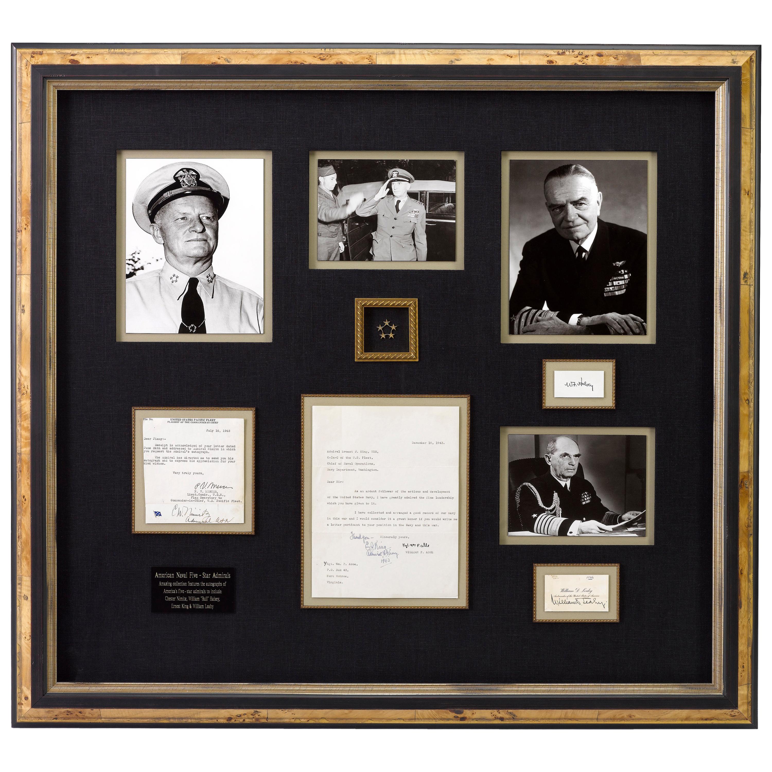
View AllNavy Five-Star Admirals Signatures, United States World War II
Located in Colorado Springs, CO
This amazing piece of U.S. Naval history features signed items from all four World War II Navy Admirals to ever wear the five-star rank. All are cons...
Category
Mid-20th Century American Historical Memorabilia
Materials
Paper
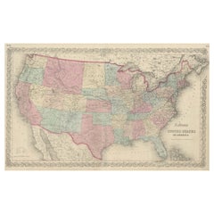
"The United States from the Latest Authorities" Antique Wall Map, 1835
Located in Colorado Springs, CO
This is a 1835 map of “The United States from the Latest Authorities” by Ezra Strong. A hand-colored engraved wall map of the eastern half of the United States, this map has a large inset of the "Oregon District" and several engraved city views and two portraits.
The primary map extends to Mexico Texas and the Missouri Territory, showing the course of the Missouri River to Ft. Mandan and Old Ft. Mandan, and noting many forts along the river. The territories to the east of Missouri Territory are separately delineated as Sioux District and Huron District. The western details of the map are very good for a map of this time period, with many Native American settlements, villages, forts and other details noted.
The map is bordered with vignettes of Boston, New York, Philadelphia, Hartford, Cincinnati, and Baltimore. Each vignette notes the date settled, primary settler, and the population as of 1830. Two portraits of LaFayette and George Washington are presented in full length with related biographical information.
A large inset map at lower right shows the Oregon District, centered on the Columbia River and extending to the Rocky Mountains. This is one of the earliest commercial appearances of a separate map of Oregon...
Category
Antique 1830s American Maps
Materials
Paper

1812 United States Map, by Pierre Tardieu, Antique French Map Depicting the U.S.
By Pierre François Tardieu
Located in Colorado Springs, CO
1812 "United States of Nth America -- Carte des Etats-Unis De L'Amerique Septentrionale" Two-Sheet Map by Tardieu
This attractive map, published in Paris in 1812, is one of the most rare large format maps from the period. It features a view of the East Coast of the U.S. from Maryland to just below South Carolina. Additionally, Ellicott’s plan for the City of Washington D.C. is included at the top right and an illustration of Niagara Falls is shown at the bottom right with a description in both French and English. This extremely detailed map not only depicts the mountainous regions of the southeastern U.S., but also includes names of regions, rivers, and towns.
Based on the first state of Arrowsmith’s 4-sheet map of the United States, this map is completely engraved by Tardieu in Paris and showcases high quality engravings. This detailed map of the recently independent United States includes one of the largest and earliest examples of the Ellicott plan of Washington DC.
The artist, Pierre François Tardieu (PF Tardieu) was a very well-known map engraver, geographer, and illustrator. Awarded a bronze medal by King Louis-Phillipe for the accuracy and beauty of his map-making, Tardieu produced many fine works including maps of Louisiana...
Category
Antique 1810s French Maps
Materials
Paper

N.E. View of the United States Capitol, Washington, DC Antique Proof Print 1858
Located in Colorado Springs, CO
This engraved print shows a view of the United States Capitol Building, in Washington, D.C. The print depicts the neoclassical building from the northeast orientation, with a bustling street scene in front. The steel engraving is a proof printing, drawn and engraved by Henry Sartain and published in 1858.
Plans began in May 1854 to build a new cast-iron dome for the United States Capitol. The then-architect of the Capitol Thomas Walter and his team were sold on the aesthetics of a new dome, as well as the utility of a fire-proof one. A year later, on March 3, 1855, President Franklin Pierce...
Category
Antique 1850s American Prints
Materials
Paper

1866 Ensign & Bridgman's Rail Road Map of the United States
Located in Colorado Springs, CO
Presented is an 1866 issue of “Ensign & Bridgeman’s Rail Road Map of the United States, showing Depots & Stations.” First published in 1856, this is the third edition, following anot...
Category
Antique 1860s American Late Victorian Maps
Materials
Paper

1847 Ornamental Map of the United States & Mexico by H. Phelps
Located in Colorado Springs, CO
Offered is an original 1847 ornamental map of the U.S. entitled "Ornamental Map of the United States & Mexico" by Humphrey Phelps. The map was issued as an act of Congress by Phelps on Fulton Street, New York. The broadside is elaborately hand-colored.
This is a very detailed and graphic propaganda map of the United States expressing U.S. dominance of the North American continent. The hand-colored map proclaims the Manifest Destiny, with the recent acquisition of Upper California and Texas at the conclusion of the Mexican-American War. The newly acquired land is boldly colored, standing in stark contrast to the rest of the U.S. The map details a potential route for a railroad running from New York City, to Buffalo, to Chicago, then west along the Oregon Trail to Oregon City. This route anticipates the construction of the transcontinental railroad by nearly 20 years.
The map includes elaborately detailed renderings of George Washington, Hernan Cortez, and Montezuma at top to represent European expansion to the Americas. At bottom are four inset designs with text showing the following: a chronological history of the U.S. beginning from settlement to the U.S. victory in the Mexican-American war; an illustration of General Zachary Taylor with details on the Oregon Territory; an illustration of the Aztec Temple of the Sun in Tenochtitlan and a chronology of the Conquest of the Aztec Empire under Cortez; a portrait of General Antonio Lopez de Santa Anna...
Category
Antique 1840s American Maps
Materials
Paper

You May Also Like
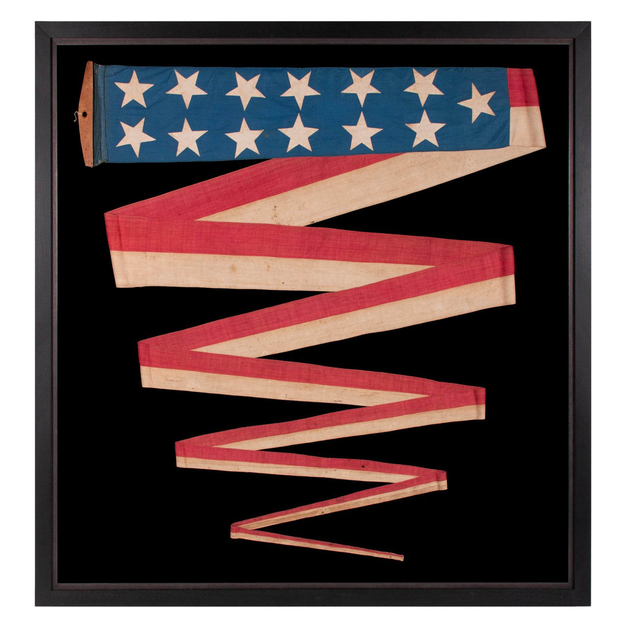
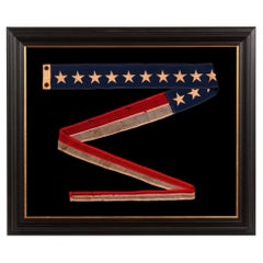
Hand-Sewn 13 Star Cornflower Blue 32 Foot Commission Pennant circa 1845-1865
Located in York County, PA
ENTIRELY HAND-SEWN, 32-FOOT, SHIP’S COMMISSION PENNANT OF THE 1845-1865 ERA, A HOMEMADE, COTTON EXAMPLE, WITH 13 STARS ON A CORNFLOWER BLUE CANTON, IN A BEAUTIFUL STATE OF PRESERVATION
Commission pennants are the distinguishing mark of a commissioned U.S. Navy ship. A ship becomes commissioned when the pennant is hoisted. Flown during both times of peace and war, the only time it is not flown is if a flag officer or civilian official is aboard and replaces it with their own flag. Flown at the topmast, this would be the first thing one would see coming over the horizon and identified the vessel as a warship.
Sometimes the owners of private ships mimicked the use of Navy signals. Some seafaring men would have served in the Navy and become privy to various practices in that capacity. Others flew them purely for stylistic reasons, either on a regular basis or while the boat was dressed for special occasion. Hudson River steamers regularly flew pennants of this nature, as evidenced by period photography as well as the paintings of artists such as John and James Bard...
Category
Antique Mid-19th Century American Political and Patriotic Memorabilia
Materials
Cotton
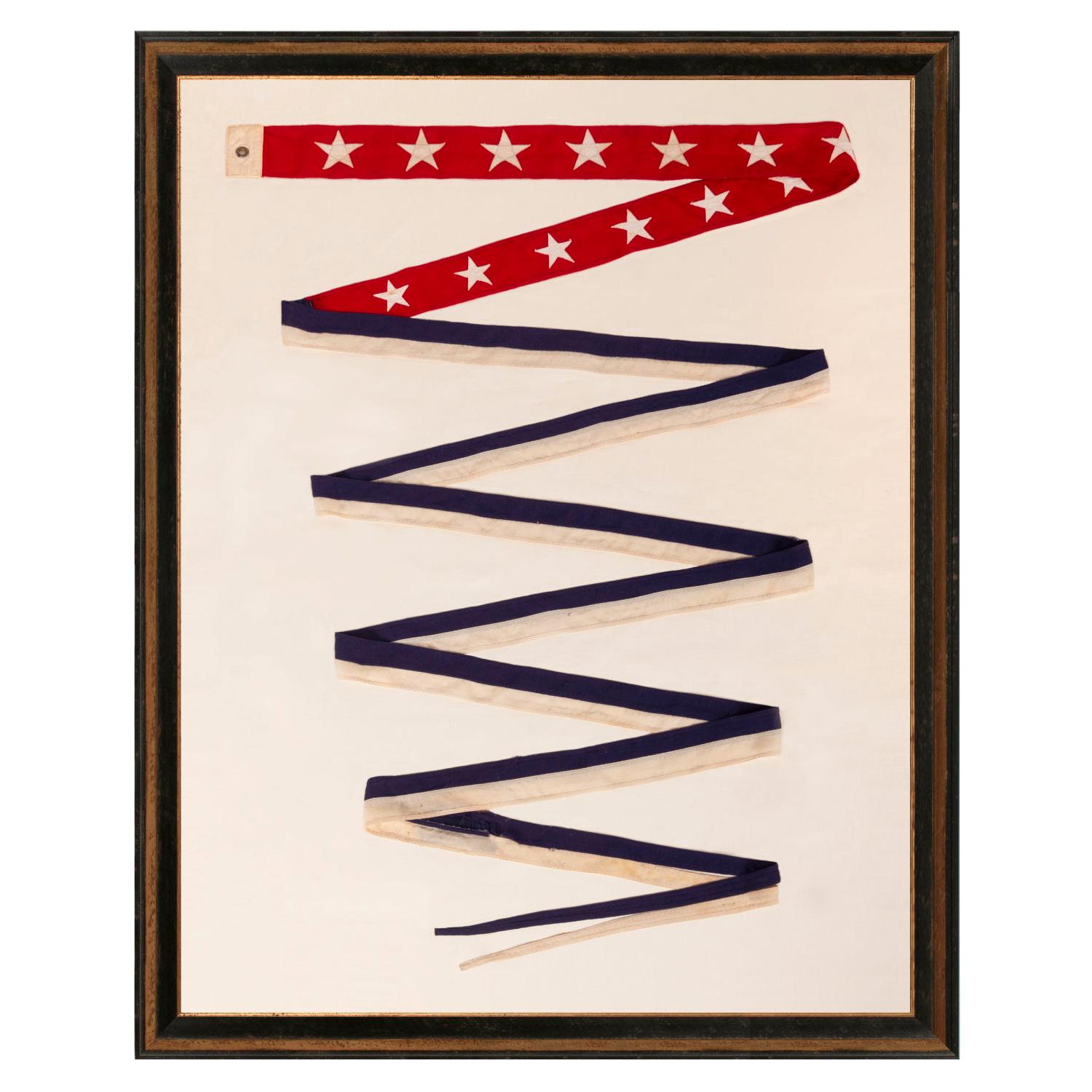
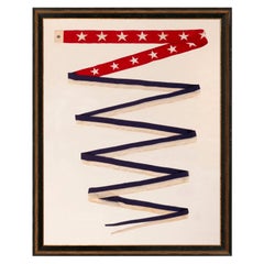
U.S War Department Commissioning Pennant with 13 Stars
Located in York County, PA
EXTREMELY RARE U.S. WAR DEPARTMENT COMMISSIONING PENNANT WITH 13 STARS, A REVERSAL OF THE U.S. NAVY COLOR SCHEME, TWENTY-FOUR FEET ON THE FLY, SP...
Category
20th Century American Political and Patriotic Memorabilia
Materials
Wool
Price Upon Request
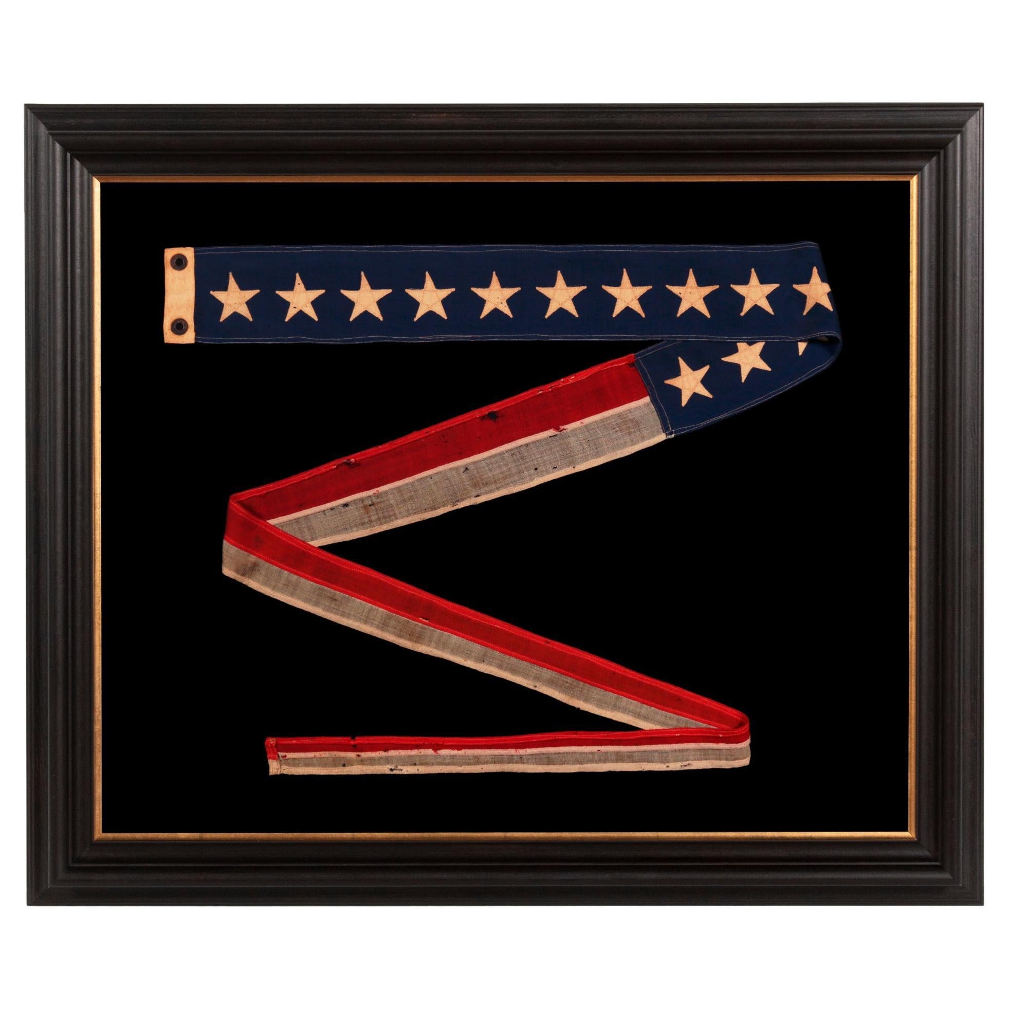
Commission Pennant with 13 Stars, like for Private Vessel, Ca 1892-1910
Located in York County, PA
Commission pennants are the distinguishing mark of a commissioned U.S. Navy ship. Flown at the topmast, the typical American format is a long blue field, usually with a single row of white stars, although sometimes with their total divided into two rows, followed by two long stripes, red-over-white. A ship became commissioned when this pennant was hoisted. Flown during both times of peace and war, the only time the pennant is not flown is if a flag officer or civilian official was aboard and replaced it with their own flag.
Sometimes the owners of private ships mimicked the use of Navy signals. Some seafaring men would have served in the Navy and become privy to various practices in that capacity. Others flew them purely for stylistic reasons, either on a regular basis or while the boat was dressed for special occasion. Hudson River steamers regularly flew pennants of this nature, as evidenced by period photography as well as the paintings of artists such as John and James Bard...
Category
Antique Late 19th Century American Political and Patriotic Memorabilia
Materials
Wool
Price Upon Request
Antique Map Colton's United States of America
Located in Langweer, NL
Antique map titled 'Colton's United States of America'. Show railroads, canals, state capitals, major cities and towns, military posts, historic trails, Pony Express and U.S. mail routes; Dakota [Territory] extending deep into Nebraska, and Idaho [Territory] encompassing [modern day] Montana and Wyoming; Indian Territory...
Category
Antique Mid-19th Century Maps
Materials
Paper
$845 Sale Price
20% Off
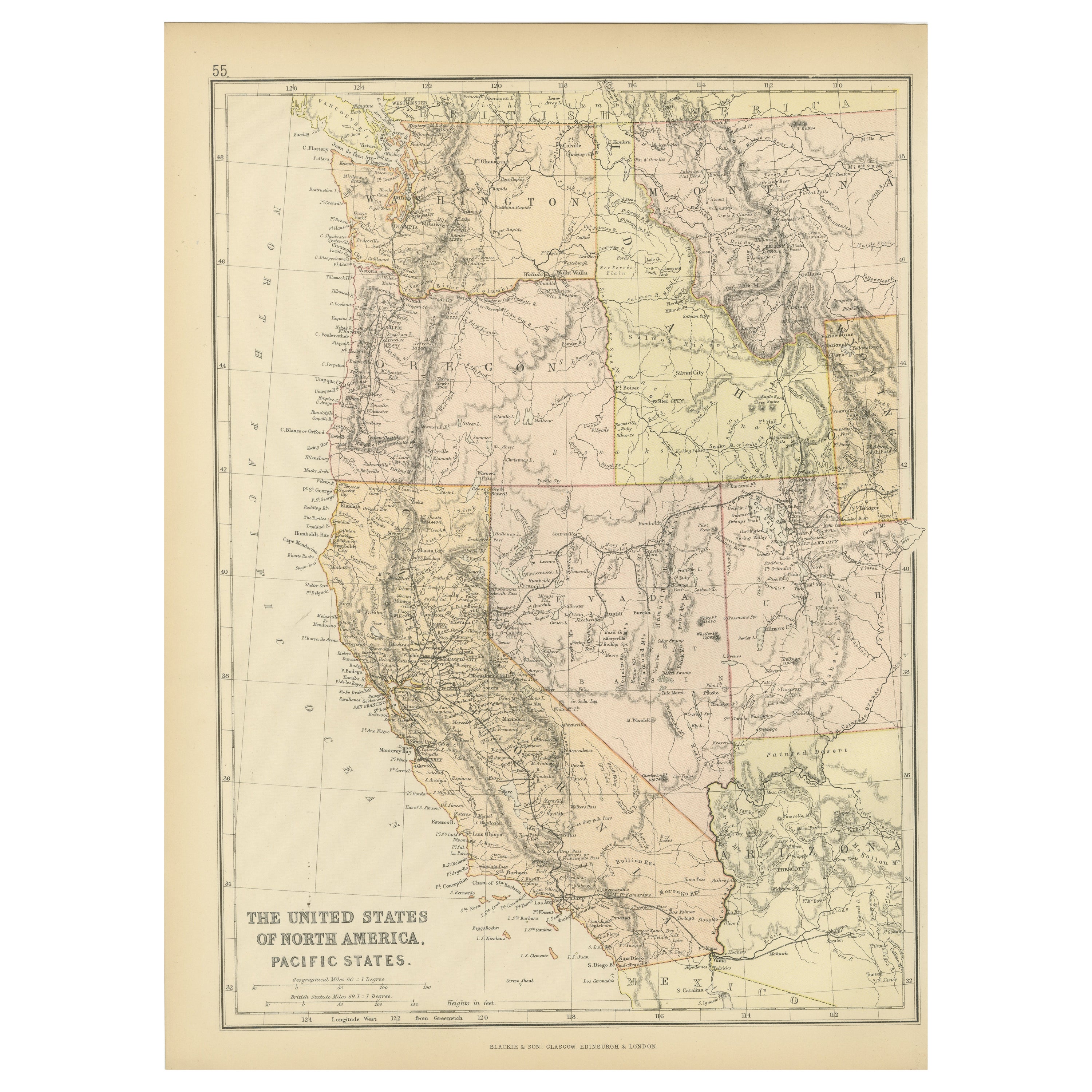
Antique Map of The United States of North America, Pacific States, 1882
Located in Langweer, NL
The map is from the same 1882 Blackie Atlas and focuses on the Pacific States of the United States of America during that period. Here are some details and historical context about t...
Category
Antique 1880s Maps
Materials
Paper

$237 Sale Price
20% Off
Free Shipping
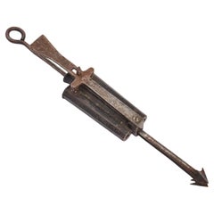
A poacher trap, United States 1860.
Located in Milan, IT
A percussion poacher trap F. Reuthes Patent: 30 Caliber; 100mm (4") octagonal iron barrels with “ F. Reuthe's patent may 12 1857”. Spring arrow. USA circa 1860.
Category
Antique Mid-19th Century American Arms, Armor and Weapons
Materials
Iron
Recently Viewed
View AllMore Ways To Browse
Antique White Sewing Machine
Commissioning Pennant
Naval Furniture
Used Yacht Furniture
Boat Collectables
Ship Captain
Collectable Brass Ship
Nautical Antiques
Vintage Nautical
Nautical Antiques Furniture
Yacht America
Marine Collectibles
Ships Wheel
Antique Nautical Brass
Used Ship Rope
Nautical Anchor
Ship Window
Antique Wood Wheel