Items Similar to 1855 Astronomical Plate of Distance of the Planets by FJ Huntington New York

Want more images or videos?
Request additional images or videos from the seller
1 of 20
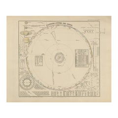
1855 Astronomical Plate of Distance of the Planets by FJ Huntington New York
$1,437.29
£1,065.11
€1,200
CA$1,962.17
A$2,182.83
CHF 1,144.27
MX$26,673.71
NOK 14,570.84
SEK 13,716.43
DKK 9,136.69
Shipping
Retrieving quote...The 1stDibs Promise:
Authenticity Guarantee,
Money-Back Guarantee,
24-Hour Cancellation
About the Item
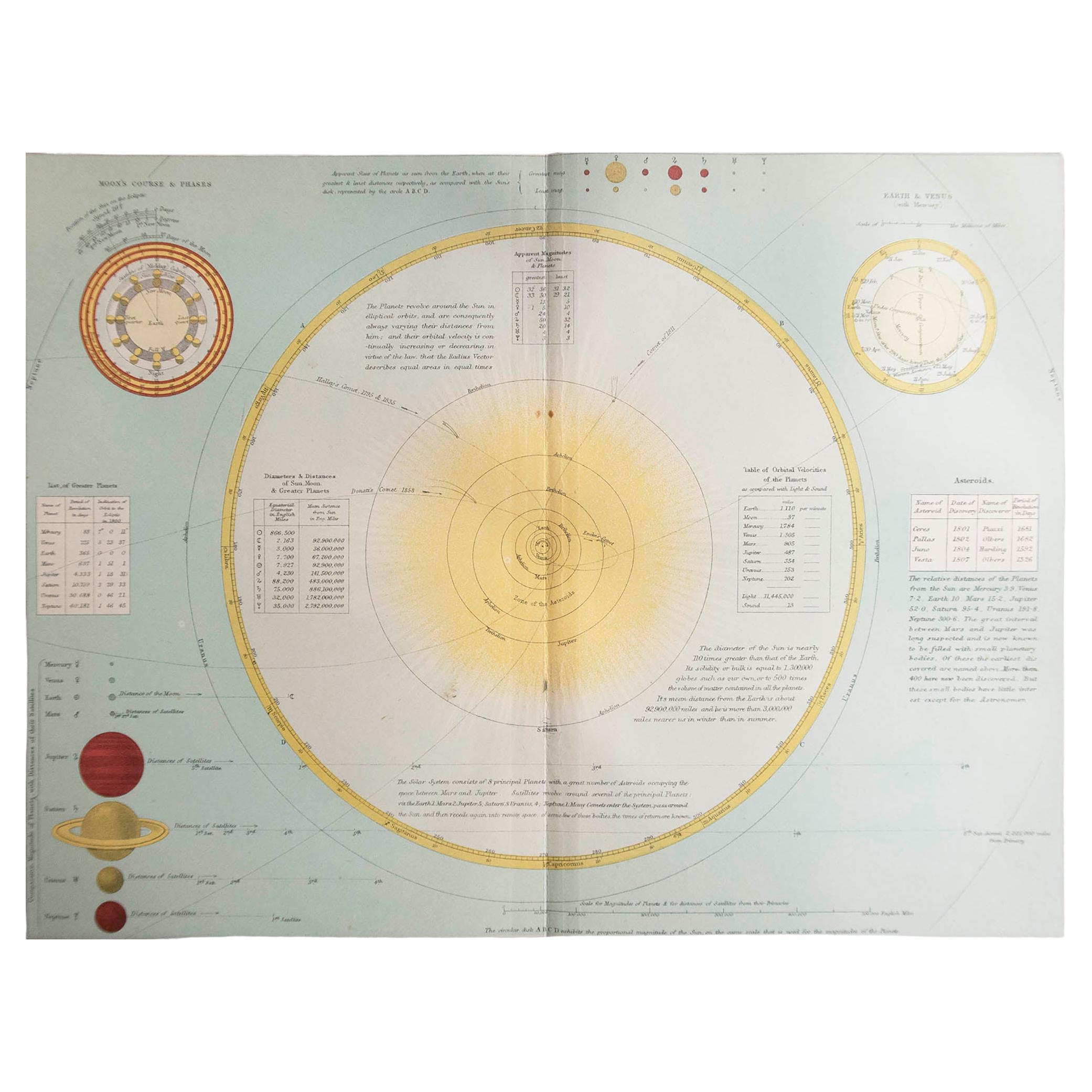
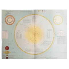
Plate of the distance of the planets “Entered according to Act of Congress in the year 1855 by F.J. Huntington in the Clerk's Office of the District Court of the United States for the Southern District of New York". The plate shows the orbit of the Moon and the various distances of the planets from the Sun, as well as a small table of the orbits and ellipticals of the primary planets. Good condition, non-coeval frame, some stains and some small cracks. With frame 81.8 x 49.8 cm - 32.2 x 16.4 inches, thickness 1.5 cm - 0.59 inches.
Francis Junius Huntington (December 3, 1802-February 5, 1878) was a publisher in Hartford, Connecticut, and New York City. Son of Hezekiah Huntington and Susan Kent, he grew up in the Hartford area and was early entered the publishing business within the city. He later moved to New York City and enlarged his business in publishing musical books in 1862.
- Dimensions:Height: 19.61 in (49.8 cm)Width: 32.21 in (81.8 cm)Depth: 0.6 in (1.5 cm)
- Materials and Techniques:
- Place of Origin:
- Period:
- Date of Manufacture:1855
- Condition:
- Seller Location:Milan, IT
- Reference Number:1stDibs: LU1020222483332
About the Seller
5.0
Vetted Professional Seller
Every seller passes strict standards for authenticity and reliability
Established in 1999
1stDibs seller since 2014
398 sales on 1stDibs
Typical response time: 1 hour
- ShippingRetrieving quote...Shipping from: Milan, Italy
- Return Policy
Authenticity Guarantee
In the unlikely event there’s an issue with an item’s authenticity, contact us within 1 year for a full refund. DetailsMoney-Back Guarantee
If your item is not as described, is damaged in transit, or does not arrive, contact us within 7 days for a full refund. Details24-Hour Cancellation
You have a 24-hour grace period in which to reconsider your purchase, with no questions asked.Vetted Professional Sellers
Our world-class sellers must adhere to strict standards for service and quality, maintaining the integrity of our listings.Price-Match Guarantee
If you find that a seller listed the same item for a lower price elsewhere, we’ll match it.Trusted Global Delivery
Our best-in-class carrier network provides specialized shipping options worldwide, including custom delivery.More From This Seller
View All1850 Old French Map Depicting the Entire Earth's Surface Divided into Two Parts
Located in Milan, IT
Geographical map depicting the entire earth’s surface divided into two parts that correspond to the two hemispheres or globes, the map deals with the latitudes and longitudes, the me...
Category
Antique Mid-19th Century French Maps
Materials
Glass, Wood, Paper

1850 Old French Map Depicting the Entire Earth's Surface Divided into Two Parts
Located in Milan, IT
Geographical map depicting the entire earth's surface divided into two parts that correspond to the two hemispheres divided into small climatic zones that depict the climatic trend f...
Category
Antique Mid-19th Century French Scientific Instruments
Materials
Glass, Wood, Paper
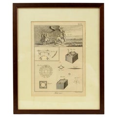
Engraving on Copper Print from the Volume Navigazione Nautical Subject 1790
Located in Milan, IT
Print by engraving on copper plate Tav III TIX fig. 17-22 from the volume Navigazione; with frame 28 x 33. Some calculations are depicted. Very good condition.
Shipping is insured by...
Category
Antique 1790s Italian Nautical Objects
Materials
Paper
1850 Old French Map Depicting the Entire Earth's Surface Divided into Two Parts
Located in Milan, IT
Map depicting the entire earth's surface divided into two parts corresponding to the two hemispheres and showing the Arctic to Antarctic polar circle, the tropics of Cancer and Capri...
Category
Antique Mid-19th Century French Maps
Materials
Glass, Wood, Paper
Old Map Depicting the Entire Earth's Surface Divided into Six Parts France 1850
Located in Milan, IT
Map depicting the entire earth's surface divided into six parts which depicts the position of peoples on Earth based on the assumption that it is impossible for each people to have t...
Category
Antique Mid-19th Century French Maps
Materials
Glass, Wood, Paper

Engraving Print from the Panckoucke Encyclopédie Nautical Subject 1782-1832
Located in Milan, IT
Print by engraving on copper plate from the Panckoucke Encyclopédie méthodique, end of the 18th century, volume Marine Planches (more than 1,500 figures dealing with all subjects on ...
Category
Antique 1790s French Nautical Objects
Materials
Paper
You May Also Like
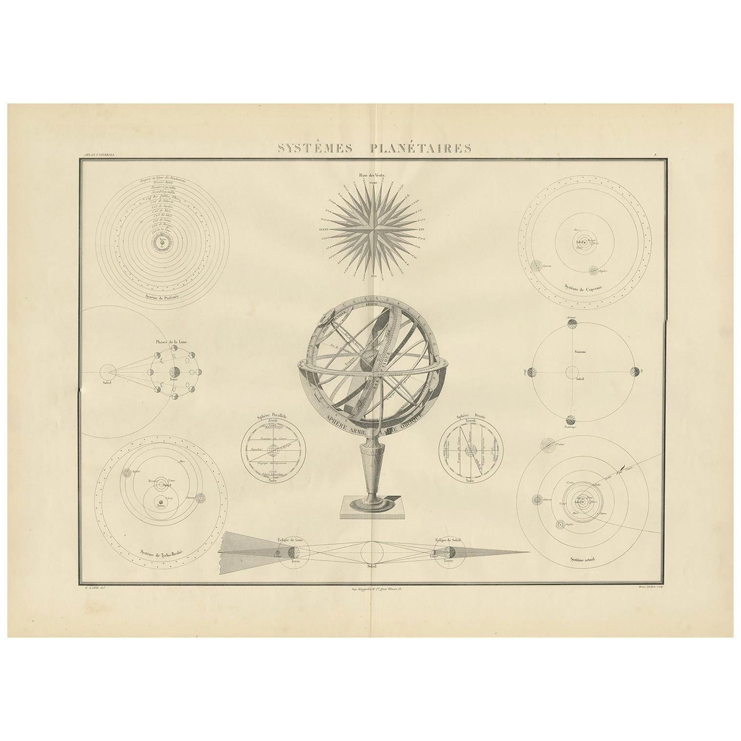
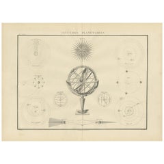
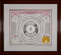
Antique Chart of Celestial and Scientific Models by Lapie, 1842
Located in Langweer, NL
Antique print titled 'Systèmes Planétaires'. Chart of various celestial and scientific models. Includes an armillary sphere and various models of the universe, the season, eclipses, a Copernican, Tycho...
Category
Antique Mid-19th Century French Prints
Materials
Paper
$718 Sale Price
25% Off
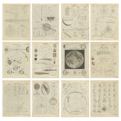
Set of 12 Antique Astronomy Prints by Bell 'c.1797'
Located in Langweer, NL
Set of twelve antique astronomy prints. Published 1787-1797 for 'Encyclopaedia Britannica'. Engraved by A. Bell.
Category
Antique Late 18th Century Prints
Materials
Paper
$958 Sale Price / set
20% Off
Original Antique Astronomy Print. C.1900
Located in St Annes, Lancashire
Great image of the solar system
Unframed.
Chromo-lithograph
Published, C.1900
The measurement is the paper size of the print
Free shipping.
Category
Antique Early 1900s English Folk Art Prints
Materials
Paper
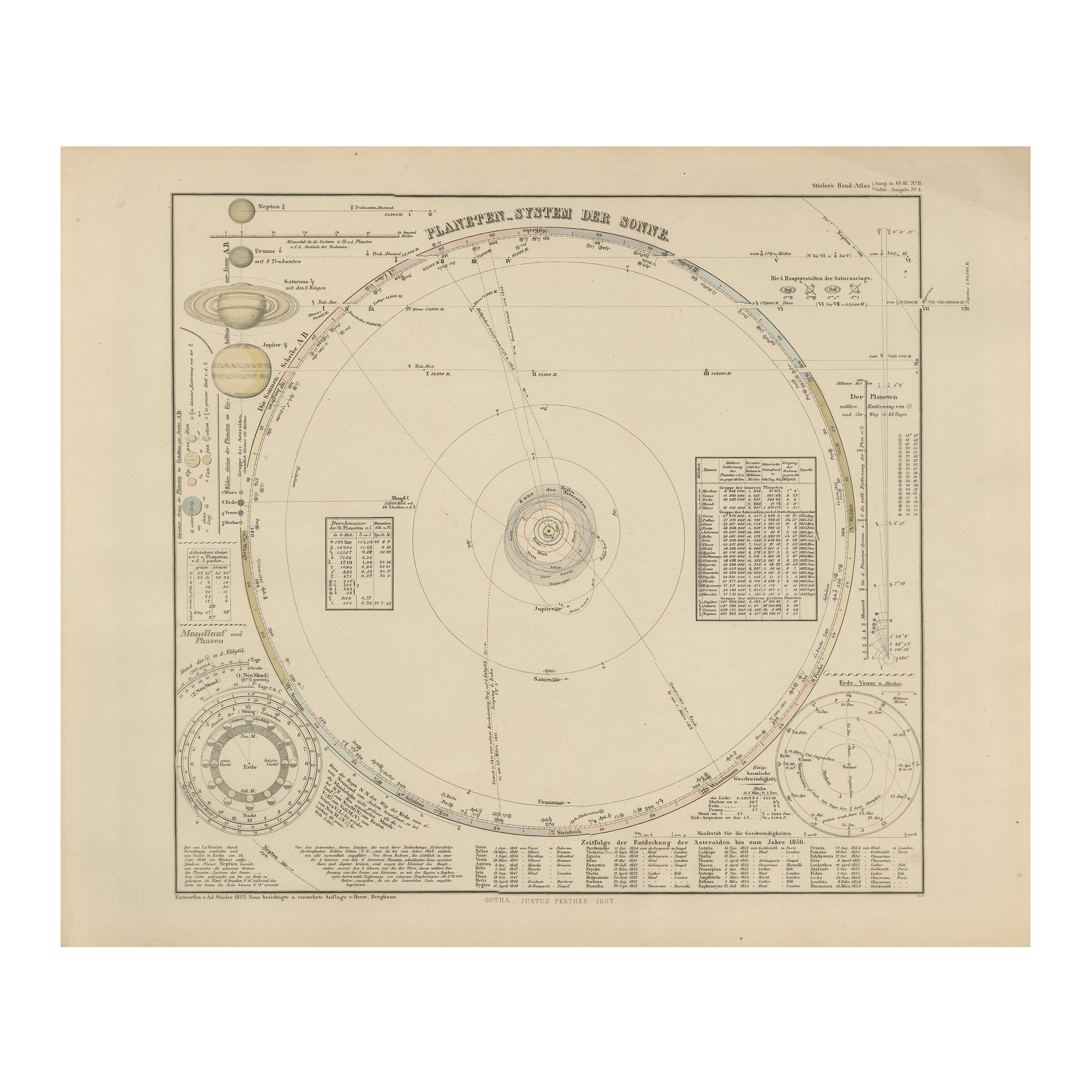
Solar System Map – Planetary Orbits and Data Chart, Published in 1857
Located in Langweer, NL
Solar System Map – Planetary Orbits and Data Chart 1857
This antique print shows a detailed diagram of the solar system titled “Planeten-System der Sonne” meaning “Planetary System ...
Category
Antique Mid-19th Century German Maps
Materials
Paper
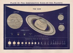
The Comparative Sizes of the Planets. Antique Astronomy diagram
Located in Melbourne, Victoria
Colour lithograph, 1890. 210mm by 285mm (sheet). From W Peck's 'A Handbook and Atlas of Astronomy', 1890. Sir William Peck FRSE FRAS (1862 – 1925) was a Scottish astronomer and scien...
Category
Late 19th Century Victorian More Prints
Materials
Lithograph
Theories of Planetary Orbits: A Framed 18th C. Celestial Map by Doppelmayr
By Johann Gabriel Doppelmayr 1
Located in Alamo, CA
This 18th century hand-colored copperplate celestial map by Johann Doppelmayr entitled "Astronomia Comparativa in qua Planetarum Primaria Phaenomena" (Co...
Category
Early 18th Century Landscape Prints
Materials
Engraving
More Ways To Browse
Wood And Sons Plate
Antique Astronomical Instruments
Optical Display
Weather Instruments
Antique Measuring Devices
Thermometer Brass
Antique Iron Machine
Brass Compass Antique
Boston Furniture Makers
Medical Instruments
Antique Wooden Barrels
Brass Telescopes
Antique Brass Scale Weights Scales
Antique French Opera Glasses
Antique Pump
Antique Pumps
Antique Wood Plane
Ww1 Furniture