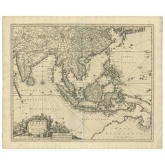
Items Similar to Antique Voc Print Holland Malaysia Old Map Melaka History, 1663

Want more images or videos?
Request additional images or videos from the seller
1 of 5
Antique Voc Print Holland Malaysia Old Map Melaka History, 1663
$293.60
$36720% Off
£222.78
£278.4720% Off
€254.73
€318.4120% Off
CA$410.08
CA$512.6020% Off
A$455.95
A$569.9420% Off
CHF 238.07
CHF 297.5920% Off
MX$5,550.05
MX$6,937.5720% Off
NOK 3,037.71
NOK 3,797.1420% Off
SEK 2,846.19
SEK 3,557.7420% Off
DKK 1,901.06
DKK 2,376.3320% Off
Shipping
Retrieving quote...The 1stDibs Promise:
Authenticity Guarantee,
Money-Back Guarantee,
24-Hour Cancellation
About the Item
From my own collection I offer this impressive Antique print of the city of Malakka
A very interesting piece for collectors . It is an museum piece from the Dutch Institute of Oriental studies. This historically very valuable Print is in amazing condition, fully original, entirely complete. This is an excellent opportunity for a serious collector or an earnest dealer to get this impressive Print for an honest price.
Additional information:
Type: Map
Country of Manufacturing: Europe
Period: 17th century Qing (1661 - 1912)
Condition: Overall Condition A (Good ): Some trace of use.
Dimension: 31.5 W x 23 H cm
- Dimensions:Height: 9.06 in (23 cm)Width: 12.41 in (31.5 cm)Depth: 0.04 in (1 mm)
- Materials and Techniques:
- Place of Origin:
- Period:
- Date of Manufacture:1663
- Condition:Overall Condition A (Good ): Some trace of use.
- Seller Location:Amsterdam, NL
- Reference Number:Seller: 1344408030001stDibs: LU4863236034512
About the Seller
5.0
Platinum Seller
Premium sellers with a 4.7+ rating and 24-hour response times
Established in 2015
1stDibs seller since 2019
264 sales on 1stDibs
Typical response time: 2 hours
- ShippingRetrieving quote...Shipping from: Amsterdam, Netherlands
- Return Policy
Authenticity Guarantee
In the unlikely event there’s an issue with an item’s authenticity, contact us within 1 year for a full refund. DetailsMoney-Back Guarantee
If your item is not as described, is damaged in transit, or does not arrive, contact us within 7 days for a full refund. Details24-Hour Cancellation
You have a 24-hour grace period in which to reconsider your purchase, with no questions asked.Vetted Professional Sellers
Our world-class sellers must adhere to strict standards for service and quality, maintaining the integrity of our listings.Price-Match Guarantee
If you find that a seller listed the same item for a lower price elsewhere, we’ll match it.Trusted Global Delivery
Our best-in-class carrier network provides specialized shipping options worldwide, including custom delivery.More From This Seller
View AllAntique French Map of Asia Including China Indoneseia India, 1783
Located in Amsterdam, Noord Holland
Very nice map of Asia. 1783 Dedie au Roy.
Additional information:
Country of Manufacturing: Europe
Period: 18th century Qing (1661 - 1912)
Condition: Overall Condition B (Good Used)...
Category
Antique 18th Century European Maps
Materials
Paper

$648 Sale Price
20% Off
Antique 1803 Italian Map of Asia Including China Indoneseia India
Located in Amsterdam, Noord Holland
Antique 1803 Italian Map of Asia Including China Indoneseia India
Very nice map of Asia. 1803.
Additional information:
Type: Map
Country of Manufacturing: Europe
Period: 19th centu...
Category
Antique 19th Century European Maps
Materials
Paper

$584 Sale Price
20% Off
Super Rare Antique French Map of Chine and the Chinese Empire, 1780
Located in Amsterdam, Noord Holland
Super Rare Antique French Map of Chine and the Chinese Empire, 1780
Very nice map of Asia. 1780 Made by Bonne.
Additional information:
Type: Map
...
Category
Antique 18th Century European Maps
Materials
Paper

$584 Sale Price
33% Off
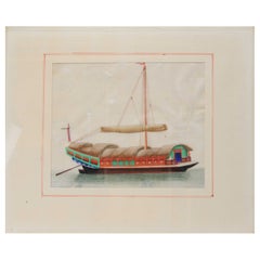
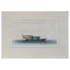
Antique Chinese Rice Pit painting of a Boat Top Quality Canton, 19th Century
Located in Amsterdam, Noord Holland
Antique Chinese Rice Pit painting of a Boat Top Quality Canton, 19th Century.
Fabulous painting.
Additional information:
Material: Porcelain & Pottery
Type:...
Category
Antique 19th Century Chinese Paintings
Materials
Porcelain
$669 Sale Price
20% Off
Antique Painting Indonesia 1931 Sumatra Telok betong Sea Landscape Van Zengen
Located in Amsterdam, Noord Holland
Beautifully painted
Condition
Good condition. Size. 88x 69 cm
Category
20th Century Edo Paintings
Materials
Silk

$2,302 Sale Price
20% Off
You May Also Like
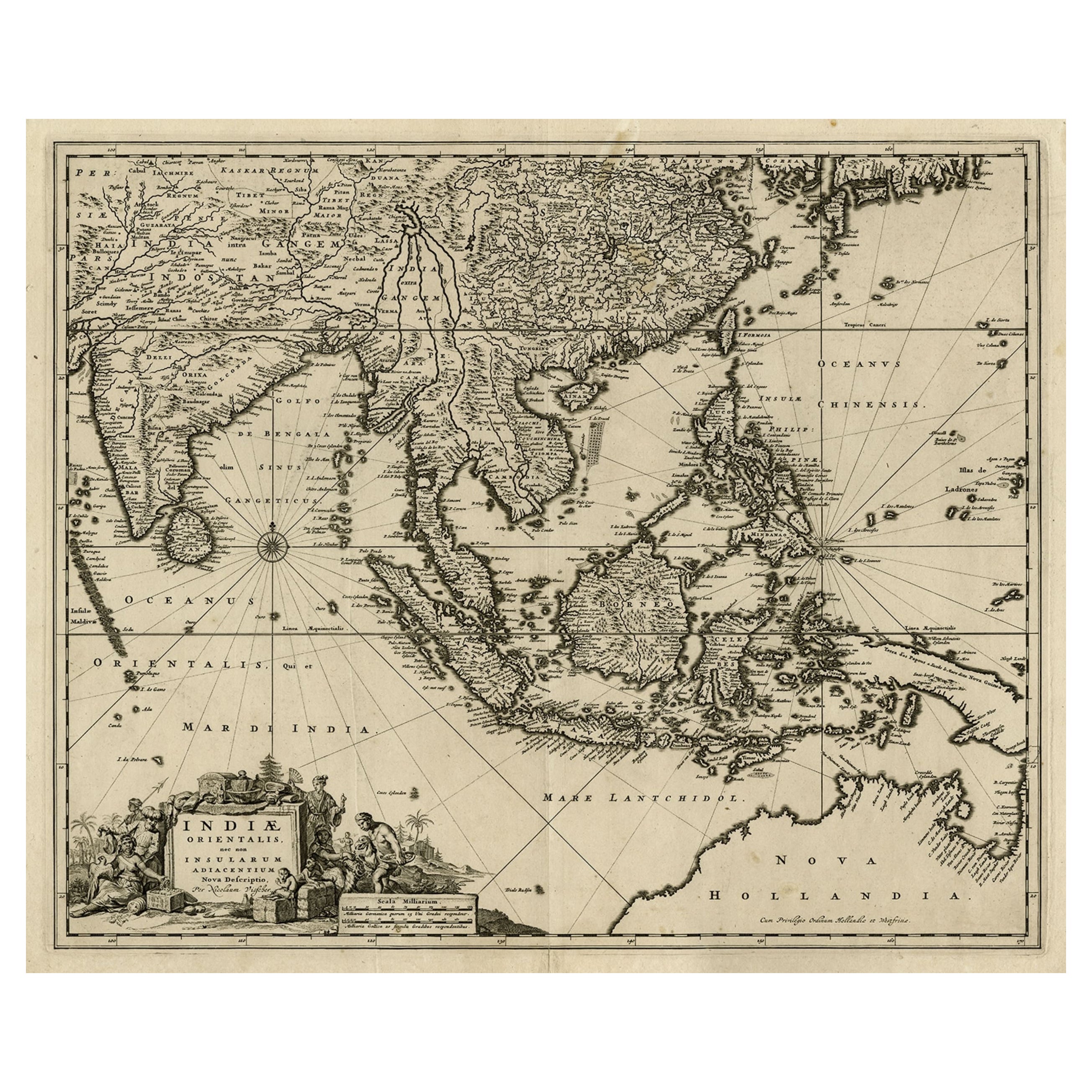
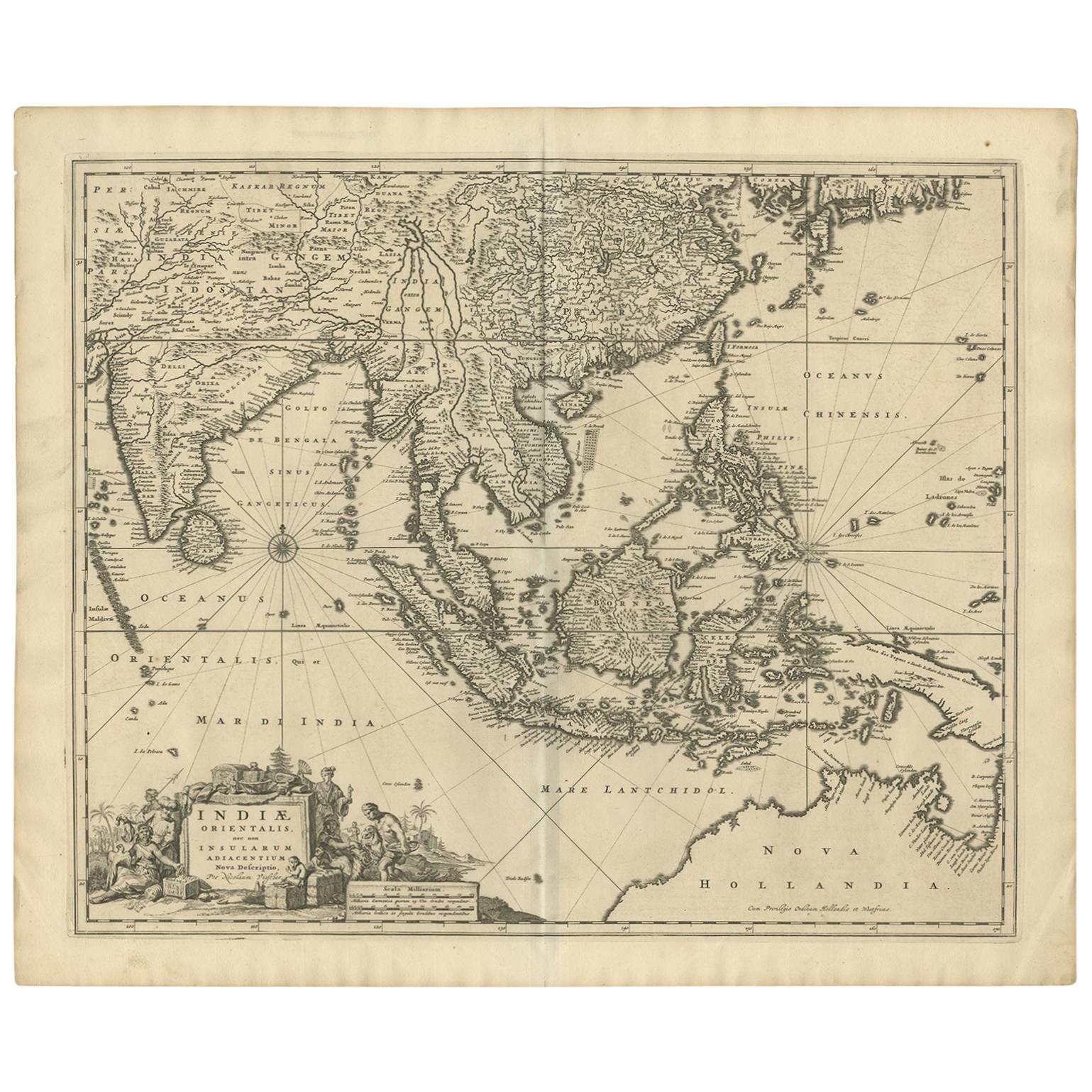
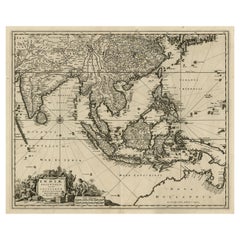
Antique Map of the Strait of Malacca, Malay Peninsula & Dutch Indies, c.1670
Located in Langweer, NL
Antique map titled 'Indiae Orientalis, nec non Insularum Adiacentium Nova Descriptio.'
Map of Southeast Asia. The map centers on the Strait of Malacca and Malay Peninsula. It ext...
Category
Antique 1670s Maps
Materials
Paper
$2,254 Sale Price
20% Off
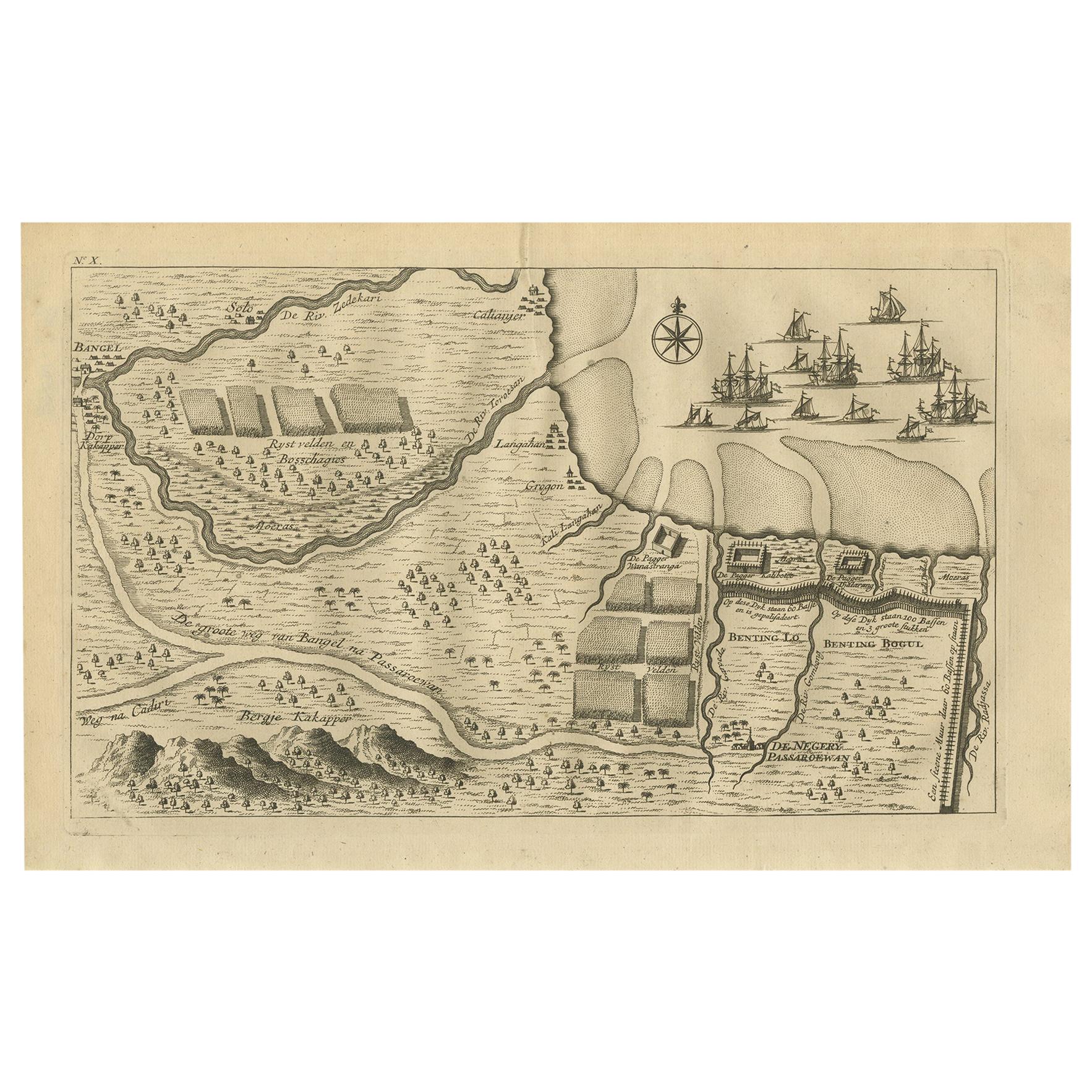
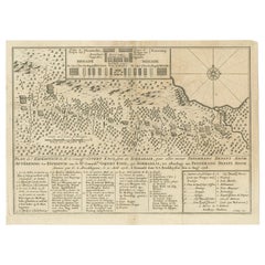
Antique Print of the Region around Pasuruan Indonesia by Valentijn '1726'
Located in Langweer, NL
Antique print of the region around Pasuruan near Surabaya, Indonesia. It shows the location of rice fields, the village Bangil, as well as three places named Pagger (also Pagar), a cluster of buildings surrounded by a bamboo fence. The location of a earthen wall with pallisade and small cannons...
Category
Antique Mid-18th Century Prints
Materials
Paper
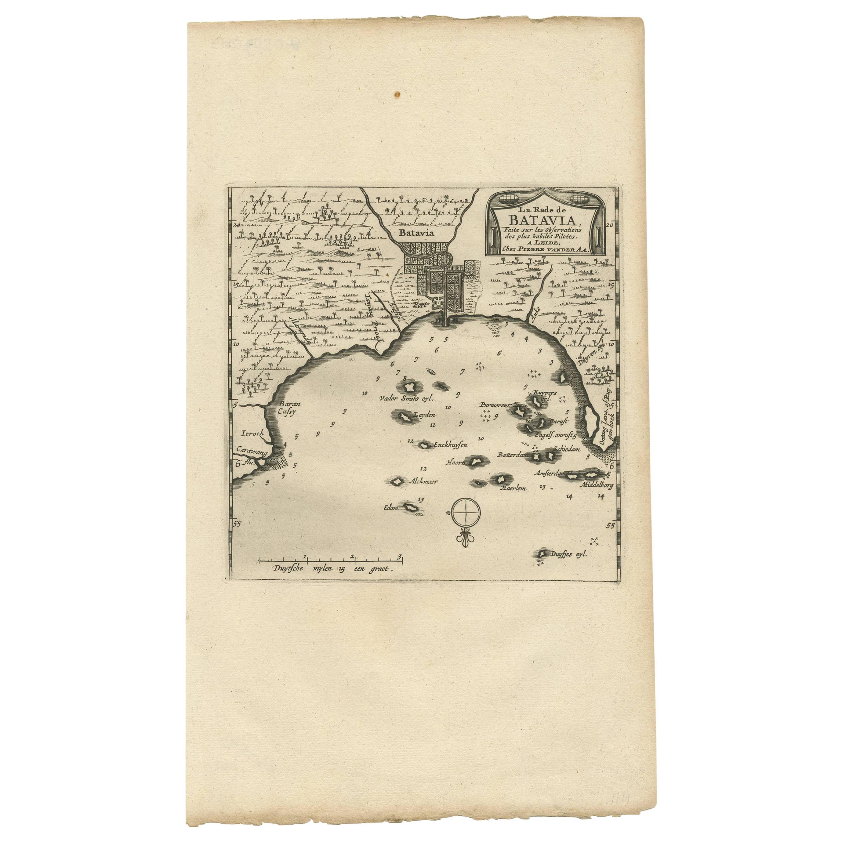
Antique Map of Batavia, Jakarta, Indonesia by P. Van Der Aa, 1719
Located in Langweer, NL
A small early 18th century black and white map of Batavia by the Dutch cartographer Pieter Van Der Aa. This map was first published in his 'Nouvel ...
Category
Antique Early 18th Century Prints
Materials
Paper

$350 Sale Price
20% Off
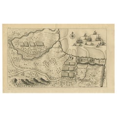
Antique Print of the Expedition of Govert Knol from Surabaya to Pangerang, 1750
Located in Langweer, NL
Antique print titled 'Aftekening der Expeditie van de Hr. Commissaris Govert Cnoll uyt Soerabaja, tot afhalinge van Pangerang Adepati Anom'. Map showing the expedition of Commissione...
Category
Antique Mid-18th Century Prints
Materials
Paper
$115 Sale Price
20% Off
Antique Map of Southeast Asia 'India, Indonesia' by N. Visscher, circa 1670
Located in Langweer, NL
Antique map titled 'Indiae Orientalis, nec non Insularum Adiacentium Nova Descriptio.' The map centers on the Strait of Malacca and Malay Peninsula. It extends from India and the Mal...
Category
Antique Mid-17th Century Maps
Materials
Paper
$1,870 Sale Price
20% Off
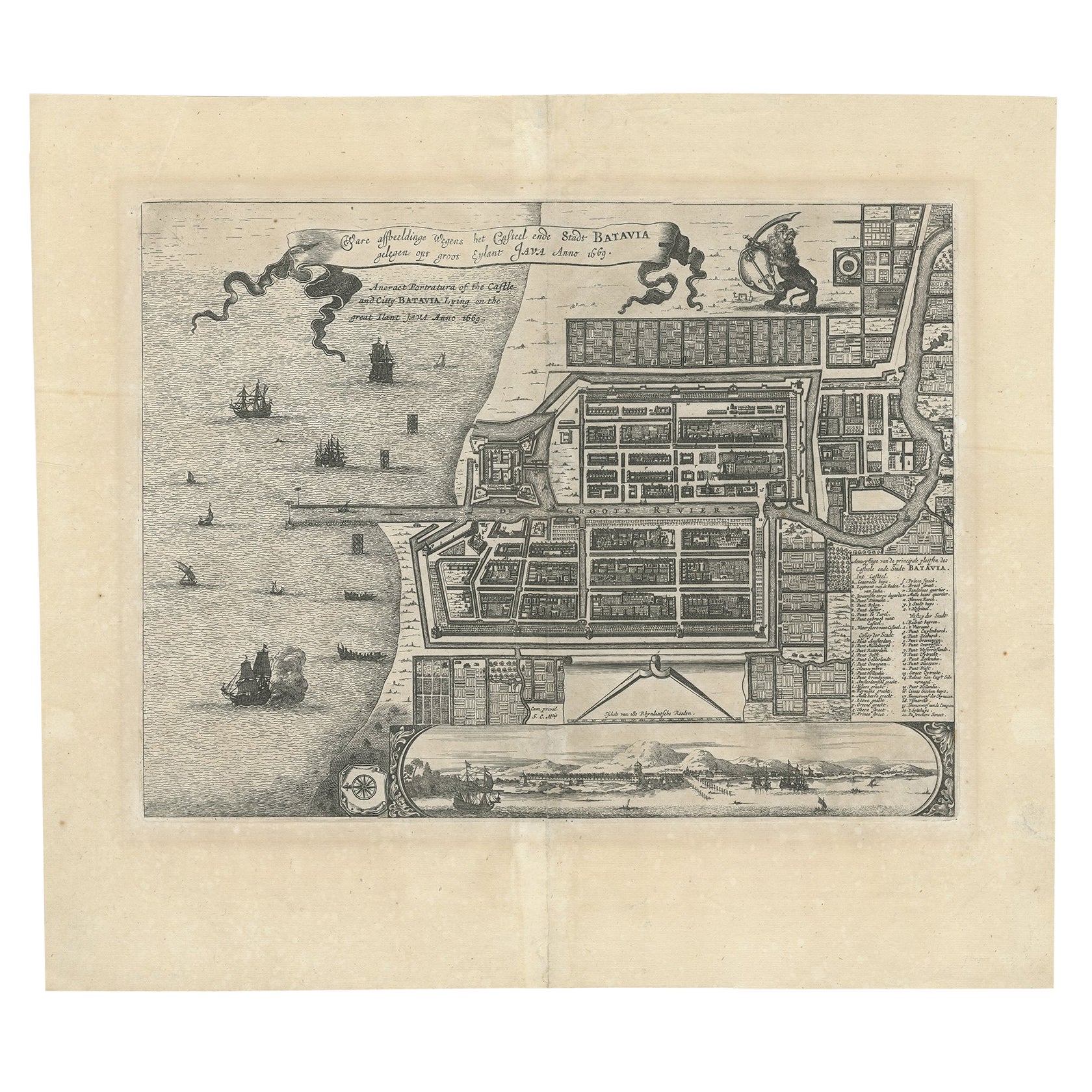
Antique Map of Batavia 'Jakarta', Indonesia by Montanus, circa 1669
Located in Langweer, NL
Antique map Batavia titled 'Ware Affbeeldinge wegens het Casteel ende Stadt Batavia'. Antique print of the castle and city of Batavia on the Island of Java'. Rare edition with Englis...
Category
Antique 17th Century Maps
Materials
Paper

$1,199 Sale Price
20% Off