Items Similar to Original Antique Poster Northumberland Holidays Rail Travel Map Golf Roman Wall

Want more images or videos?
Request additional images or videos from the seller
1 of 5
Original Antique Poster Northumberland Holidays Rail Travel Map Golf Roman Wall
$1,905.11
£1,400
€1,644.77
CA$2,617.30
A$2,921.97
CHF 1,531.07
MX$35,767.78
NOK 19,444.58
SEK 18,333.77
DKK 12,275.07
About the Item
Original antique train travel poster issued by NER North Eastern Railway - Northumberland for the Holidays Coast Dale & Borderland Ancient Castles & The Roman Wall - featuring a pictorial map illustration by the English artist Frank Henry Mason (1875-1965) depicting an aerial view over North East England with buildings, roads, rivers and hills and various places of interest including The Cheviots (the Cheviot Hills range of uplands on the Anglo-Scottish border), the Roman Wall (the historic Hadrian's Wall a former defensive fortification built by the Roman province of Britannia), the Tynedale and Allendale village and civil parish with sandy beaches along the coast of the North Sea and ships and sailing boats by the mouth of the River Tyne with a smaller map on the side and note that the red flags indicate golf courses. Horizontal. Large size. Good condition, folds, creasing, minor tears, minor discolouration.
- Creator:Frank Henry Mason (Artist)
- Dimensions:Height: 39.97 in (101.5 cm)Width: 49.81 in (126.5 cm)Depth: 0.04 in (1 mm)
- Materials and Techniques:
- Place of Origin:
- Period:
- Date of Manufacture:1920
- Condition:Good condition, folds, creasing, minor tears, minor discolouration.
- Seller Location:London, GB
- Reference Number:1stDibs: LU1012624579392
About the Seller
5.0
Platinum Seller
Premium sellers with a 4.7+ rating and 24-hour response times
Established in 2010
1stDibs seller since 2013
572 sales on 1stDibs
Typical response time: <1 hour
Associations
LAPADA - The Association of Arts & Antiques Dealers
- ShippingRetrieving quote...Shipping from: London, United Kingdom
- Return Policy
Authenticity Guarantee
In the unlikely event there’s an issue with an item’s authenticity, contact us within 1 year for a full refund. DetailsMoney-Back Guarantee
If your item is not as described, is damaged in transit, or does not arrive, contact us within 7 days for a full refund. Details24-Hour Cancellation
You have a 24-hour grace period in which to reconsider your purchase, with no questions asked.Vetted Professional Sellers
Our world-class sellers must adhere to strict standards for service and quality, maintaining the integrity of our listings.Price-Match Guarantee
If you find that a seller listed the same item for a lower price elsewhere, we’ll match it.Trusted Global Delivery
Our best-in-class carrier network provides specialized shipping options worldwide, including custom delivery.More From This Seller
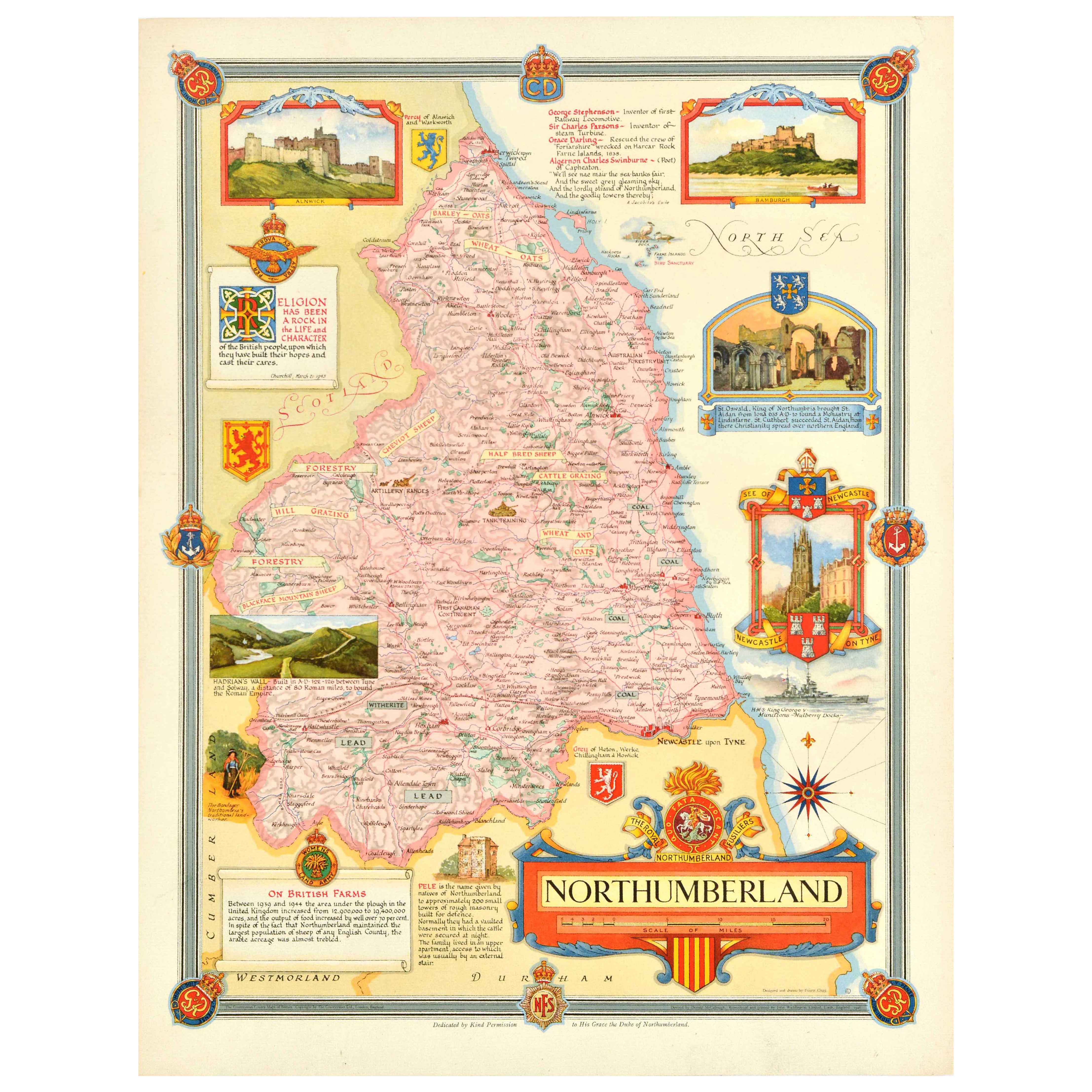
View AllOriginal Vintage Post-World War Two Map Poster Northumberland UK WWII Clegg
Located in London, GB
Original vintage post-World War Two map poster for Northumberland in north east England featuring a colourful design by Ernest Costain Clegg (1876-1954) of the ceremonial county with...
Category
Vintage 1940s British Posters
Materials
Paper
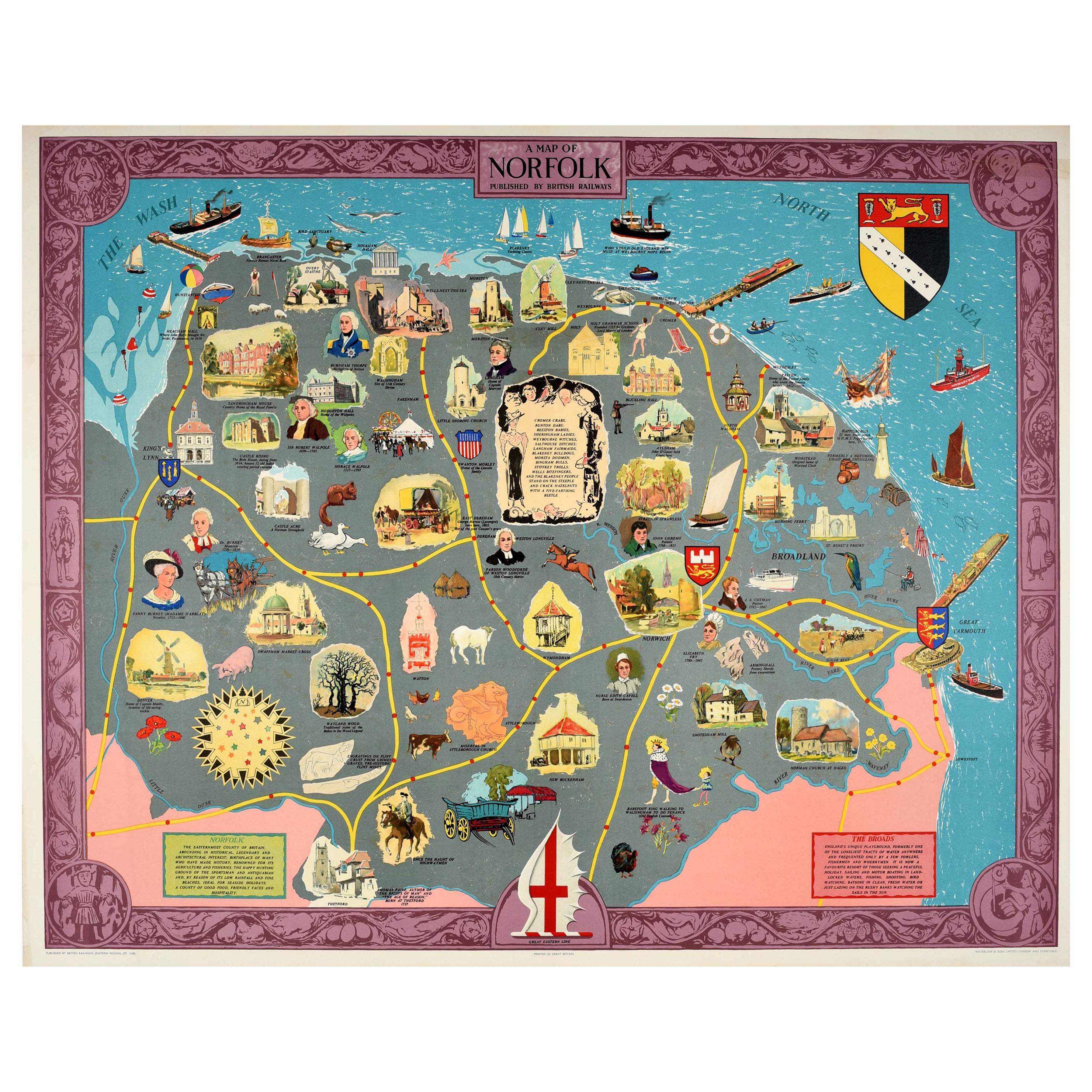
Original Vintage Travel Advertising Poster Map Of Norfolk British Railways UK
Located in London, GB
Original vintage travel advertising poster - A Map of Norfolk published by British Railways - featuring various colourful historical, sporting and cultural images with description text, including sailing boats, farm animals, ruins and notable people with a route line, coat of arms and decorative border. Norfolk is located in East Anglia bordered by Lincolnshire, Cambridgeshire, Suffolk, the North Sea and The Wash. There is further information on the county of Norfolk and the Norfolk Broads...
Category
Vintage 1960s British Posters
Materials
Paper
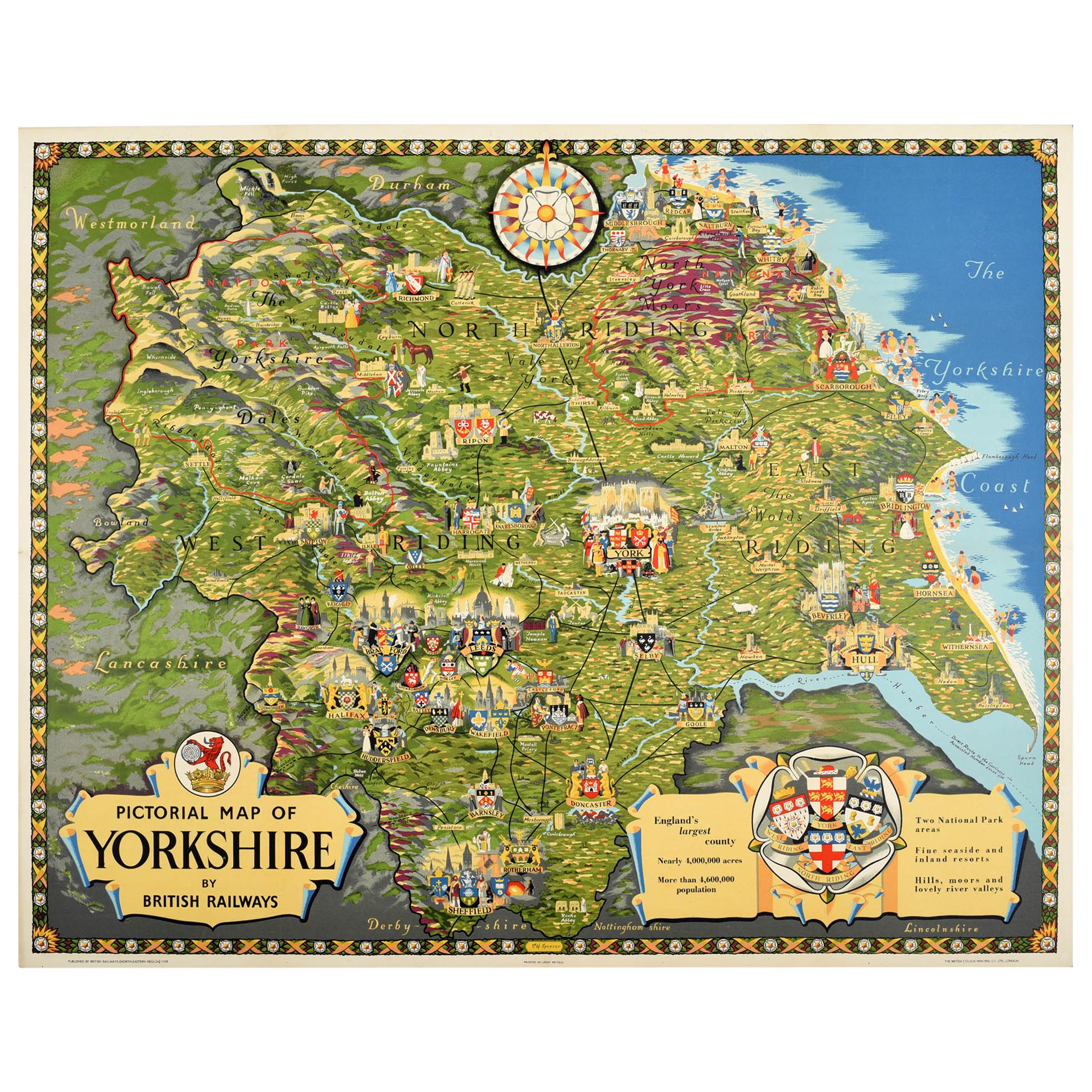
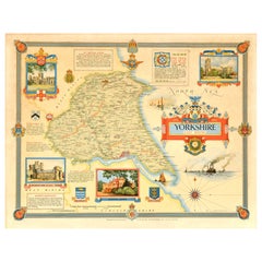
Original Vintage Poster Pictorial Map Of Yorkshire British Railways Train Travel
Located in London, GB
Original vintage train travel poster - Pictorial Map of Yorkshire by British Railways - featuring a colourful and detailed illustrated map of the historic county of Yorkshire in northern England with the coat of arms of the various towns and cities including York, Saltburn, Whitby, Scarborough, Harrogate, Doncaster, Sheffield, Ripon, Selby and Hull, various ancient and historical landmarks and points of interest, sports and other activities including people playing on the beach and swimming in the sea on the Yorkshire Coast, farming, hikers, caricatures and legends, castles and ruins, hills, national parks including the North York...
Category
Vintage 1950s British Posters
Materials
Paper
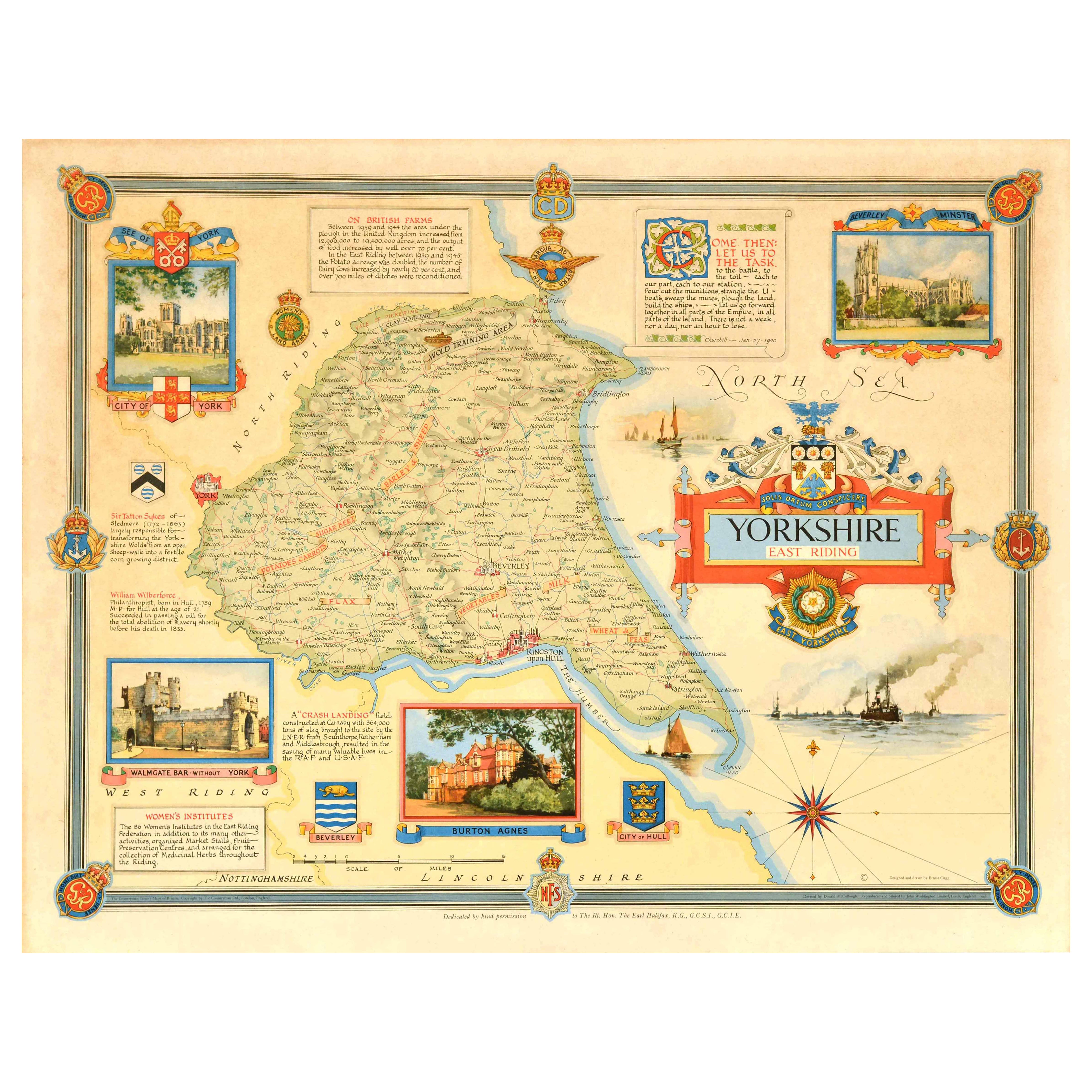
Original Vintage Post-World War Two Map Poster Yorkshire East Riding WWII Clegg
Located in London, GB
Original vintage post-World War Two map poster for Yorkshire East Riding featuring a colourful design by Ernest Costain Clegg (1876-1954) of the county in north east England with ill...
Category
Vintage 1940s British Posters
Materials
Paper
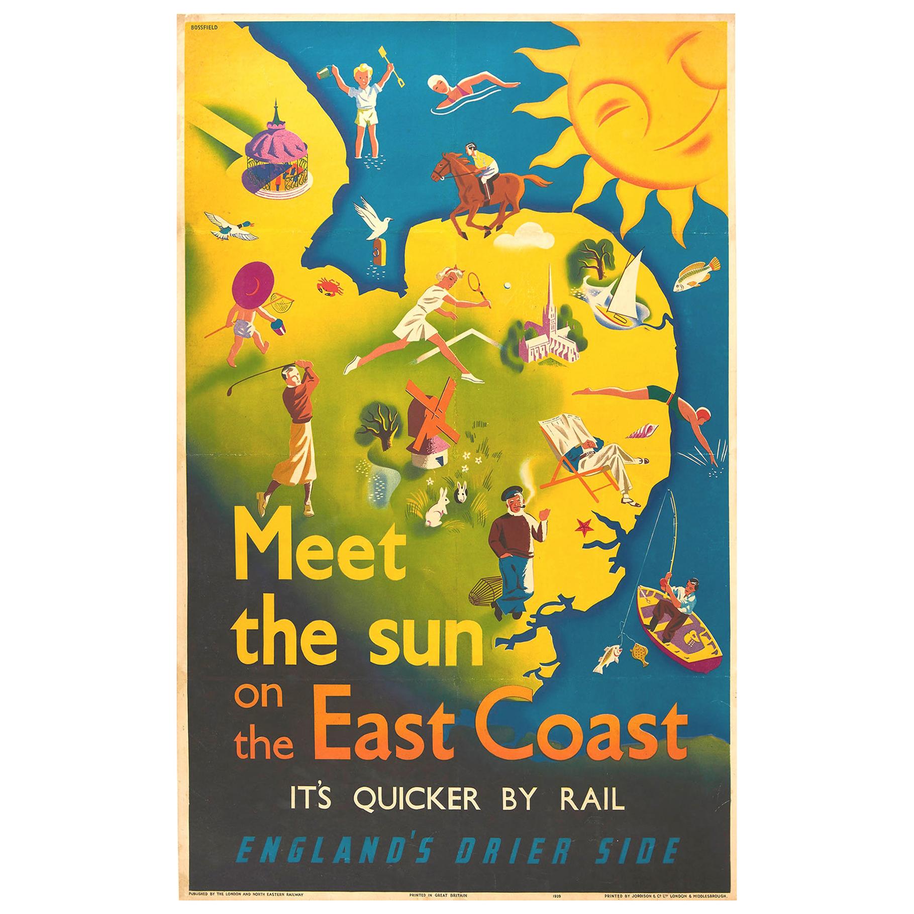
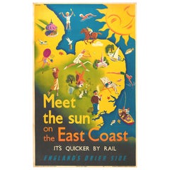
Original Vintage Poster East Coast England LNER Railway Travel Map Sun Sport Art
Located in London, GB
Original vintage LNER travel poster issued by the London and North Eastern Railway, meet the sun on the east coast it's quicker by Rail England's Drier Side, featuring a colorful summer holiday design showing a smiling sun shining down over a map of the East Coast with people enjoying various sports and activities including horse riding, swimming, sailing, tennis, golf and fishing with birds flying overhead, a rabbit poking its head from a hole to another rabbit, a child approaching a crab and a lobster fisherman...
Category
Vintage 1930s British Posters
Materials
Paper
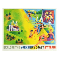
Original Vintage Railway Poster Explore The Yorkshire Coast Countryside By Train
By Reginald Lander
Located in London, GB
Original vintage travel poster promoting the Yorkshire Coast published by British Railways featuring a fun and colourful illustration of Yorkshire's tourist attractions including castle visits, golf and yachting, theatre performances, dancing, tennis and sunbathing showing various images including a smiling lady relaxing on a beach and children...
Category
Vintage 1950s British Posters
Materials
Paper
You May Also Like
Large Antique County Map of Northumberland, England
Located in Langweer, NL
Antique map titled 'A Map of Northumberland from the best Authorities'. Original old county map of Northumberland, England. Engraved by John Cary. Originates from 'New British Atlas'...
Category
Antique Early 19th Century Maps
Materials
Paper

$226 Sale Price
20% Off
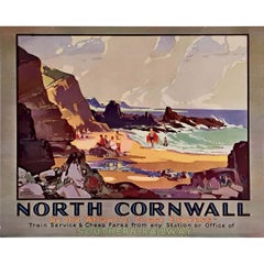
Circa 1930 original travel poster by Leonard Richmond North Cornwall’s coastline
By Leonard Richmond
Located in PARIS, FR
This delightful circa 1930 original travel poster by British painter and illustrator Leonard Richmond captures the untamed beauty and sunlit charm of North Cornwall’s coastline, as p...
Category
1930s Prints and Multiples
Materials
Lithograph, Paper, Linen
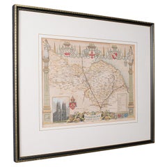
Antique North Yorkshire Map, English, Framed Lithography, Cartography, Victorian
Located in Hele, Devon, GB
This is an antique lithography map of North Yorkshire. An English, framed atlas engraving of cartographic interest, dating to the mid 19th century and later.
Superb lithography of ...
Category
Antique Mid-19th Century British Victorian Maps
Materials
Paper
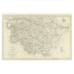
Large Antique County Map of the West Riding of Yorkshire 'South Part', England
Located in Langweer, NL
Antique map titled 'A Map of the South Part of the West Riding of Yorkshire from the best Authorities'. Original old county map of the south part of the West Riding of Yorkshire, Eng...
Category
Antique Early 19th Century Maps
Materials
Paper
$264 Sale Price
20% Off
1962 Newquay - Travel by Train - British Railways Original Vintage Poster
Located in Winchester, GB
Wonderful rare poster from 1962, produced by British Railway to promote Western Region routes to Newquay in Cornwall, England. With a wonderful image families enjoying the beautiful ...
Category
Vintage 1960s British Posters
Materials
Linen, Paper

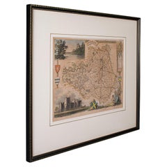
Antique Lithography Map, County Durham, English, Framed Cartography, Victorian
Located in Hele, Devon, GB
This is an antique lithography map of County Durham. An English, framed atlas engraving of cartographic interest, dating to the mid 19th century and later.
Superb lithography of Cou...
Category
Antique Mid-19th Century British Mid-Century Modern Maps
Materials
Wood
More Ways To Browse
Large Wall Maps
Scottish 1920 Furniture
Antique Furniture Northumberland
Roman Holiday Poster
Alien Posters
Austrian Chalet
Horse Racing Posters
Imperial Airways
Monaco Grand Prix Poster
Perfect Blue Poster
Rac Used Furniture
Red Shoes Poster
Rms Ship
Torino Poster
Vintage Batman Poster
Gpo Posters
Junk Boat
Kiel Furniture